

Ucayali
Encyclopedia
Lake Titicaca
Lake Titicaca is a lake located on the border of Peru and Bolivia. It sits 3,811 m above sea level, making it the highest commercially navigable lake in the world...
, in the Arequipa region
Arequipa Region
Arequipa is a region in southwestern Peru. It is bordered by the Ica, Ayacucho, Apurímac and Cusco regions on the north; the Puno Region on the east; the Moquegua Region on the south; and the Pacific Ocean on the west...
of South America
South America
South America is a continent situated in the Western Hemisphere, mostly in the Southern Hemisphere, with a relatively small portion in the Northern Hemisphere. The continent is also considered a subcontinent of the Americas. It is bordered on the west by the Pacific Ocean and on the north and east...
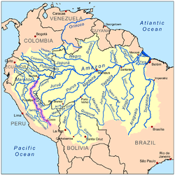
. The Amazon River
Amazon River
The Amazon of South America is the second longest river in the world and by far the largest by waterflow with an average discharge greater than the next seven largest rivers combined...
takes its name close to Nauta
Nauta
Nauta is a bustling small town situated in the northeastern area of the Peruvian Amazon roughly 100 km south of the Province's capital, Iquitos...
city (100 km away from Iquitos
Iquitos
Iquitos is the largest city in the Peruvian rainforest, with a population of 370,962. It is the capital of Loreto Region and Maynas Province.Located on the Amazon River, it is only above sea level, although it is more than from the mouth of the Amazon at Belém on the Atlantic Ocean...
), in the confluence among Ucayali and Marañón
Marañón River
The Marañón River rises about 160 km to the northeast of Lima, Peru, flows through a deeply-eroded Andean valley in a northwesterly direction, along the eastern base of the Cordillera of the Andes, as far as 5 degrees 36' southern latitude; then it makes a great bend to the northeast, and...
rivers.
The Ucayali, together with Apurímac River
Apurímac River
The Apurímac River rises from glacial meltwater of the ridge of Nevado Mismi, a mountain in the Arequipa Province in southern Peru.The Apurímac is the source of the world's largest river system, the Amazon River...
, Ene River
Ene River
The Ene River is a Peruvian river on the eastern slopes of the South American Andes.The Río Ene is part of the headwaters of the Amazon River whose origin is at the Nevado Mismi south of Cuzco where it first becomes Apurímac River, then the Ene River and Tambo River before its waters meet the...
, and Tambo River, is today considered the main headwater of the Amazon River, totaling a length of 2669.9 kilometres (1,659 mi) from the source of the Apurímac at Nevado Mismi
Nevado Mismi
Nevado Mismi is a mountain peak of volcanic origin located in the Andes mountain range of Peru. A glacial stream on the Mismi was firmly identified as the most distant source of the Amazon River in 1996; this finding was confirmed in 2001 and again in 2007....
to the confluence of the Ucayali and Marañón River
Marañón River
The Marañón River rises about 160 km to the northeast of Lima, Peru, flows through a deeply-eroded Andean valley in a northwesterly direction, along the eastern base of the Cordillera of the Andes, as far as 5 degrees 36' southern latitude; then it makes a great bend to the northeast, and...
s:
- Apurímac River (total length): 730.7 km
- Ene River (total length): 180.6 km
- Tambo River (total length): 158.5 km
- Ucayali River (confluence with Tambo River to confluence with the Marañón): 1,600.1 km
The Ucayali was first called San Miguel, then Ucayali, Ucayare, Poro, Apu-Poro, Cocama and Rio de Cuzco. Peru
Peru
Peru , officially the Republic of Peru , is a country in western South America. It is bordered on the north by Ecuador and Colombia, on the east by Brazil, on the southeast by Bolivia, on the south by Chile, and on the west by the Pacific Ocean....
has fitted out many costly and ably-conducted expeditions to explore it. One of them (1867) claimed to have reached within 380 km (236.1 mi) of Lima
Lima
Lima is the capital and the largest city of Peru. It is located in the valleys of the Chillón, Rímac and Lurín rivers, in the central part of the country, on a desert coast overlooking the Pacific Ocean. Together with the seaport of Callao, it forms a contiguous urban area known as the Lima...
, and the little steamer "Napo" forced its way up the violent currents for 124 km (77.1 mi) above the junction with the Pachitea River as far as the Tambo River, 1240 km (770.5 mi) from the confluence of the Ucayali with the Amazon. The "Napo" then succeeded in ascending the Urubamba
Urubamba River
The Urubamba River is a river in Peru. A partially navigable headwater of the Amazon River, it rises in the Andes to the south-east of Cuzco near the Puno Region border, where it is called the Vilcanota River . In the Sacred Valley, between Písac and Ollantaytambo, it is also called the Wilcamayu...
branch of the Ucayali 56 km (34.8 mi) above its union with the Tambo, to a point 320 km (198.8 mi) north of Cuzco
Cusco
Cusco , often spelled Cuzco , is a city in southeastern Peru, near the Urubamba Valley of the Andes mountain range. It is the capital of the Cusco Region as well as the Cuzco Province. In 2007, the city had a population of 358,935 which was triple the figure of 20 years ago...
.
The remainder of the Urubamba, as shown by Bosquet
Bosquet
In the French formal garden, a bosquet is a formal plantation of trees, at least five of identical species planted as a quincunx, or set in strict regularity as to rank and file, so that the trunks line up as one passes along either face...
in 1806 and Castelnau
François Louis de la Porte, comte de Castelnau
François Louis Nompar de Caumont LaPorte, comte de Castelnau was a French naturalist, known also as François Laporte or Francis de Castelnau.-Life:Born in London, he studied natural history in Paris...
in 1846, is interrupted by cascades, reefs and numberless other obstacles to navigation. Torres, who explored the Alto Ucayali for the Peruvian government, gives it a length of 186 miles (299.3 km), counting from the mouth of the Pachitea to the junction of the Tambo and Urubamba. Its width varies from 400–1200 m (1300 to 4000 feet), due to the great number of islands. The current runs from 5–6 km/h (3 to 4 miles (6.4 km) an hour), and a channel from 20–50 m (60 to 150 feet) wide can always be found with a minimum depth of 1.5 m (5 ft). There are five bad passes, due to the accumulation of trees and rafts of timber. Sometimes enormous rocks have fallen from the mountains and spread over the river-bed causing huge whirlpools.
Ucayali is home to the Amazon River Dolphin, giant otter
Giant Otter
The giant otter is a South American carnivorous mammal. It is the longest member of the Mustelidae, or weasel family, a globally successful group of predators. Unusually for a mustelid, the giant otter is a social species, with family groups typically supporting three to eight members...
, and the Amazonian Manatee
Amazonian Manatee
The Amazonian Manatee is a species of manatee that lives in the freshwater habitats of the Amazon basin. They are found in Brazil, Peru, Colombia, Ecuador, Guyana and Venezuela. Amazonian manatees are aquatic animals of the Sirenia order and are also known as "seacows". Their colour is grey but...
, which are abundant in Pacaya Samiria National Reserve, close to Nauta.
The river gives its name to the Ucayali Region
Ucayali Region
Ucayali is an inland region in Peru. Located in the Amazon rainforest, its name is derived from the Ucayali River. The regional capital is the city of Pucallpa.-Boundaries:...
of Peru
Peru
Peru , officially the Republic of Peru , is a country in western South America. It is bordered on the north by Ecuador and Colombia, on the east by Brazil, on the southeast by Bolivia, on the south by Chile, and on the west by the Pacific Ocean....
.
External links
- Amazonia biogeography - French, Spanish, English