
Washington State Route 124
Encyclopedia
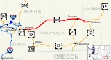
State Route 124 is a state highway
in the U.S. state
of Washington. It extends 44.68 miles (71.91 km) from US 12
in Burbank
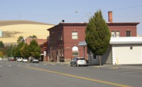
, east to US 12 in Waitsburg
. The route serves as a bypass of Walla Walla
and as a connector from US 12 to Prescott
. SR 124 was established in 1964 after the 1964 highway renumbering, along its current route. Before SR 124 was established, the route from Burbank to SR 125 was Secondary State Highway 3D and the route from SR 125 to Waitsburg was Secondary State Highway 3E.
Even though SR 124 was established in 1964, no signs went up until the law that made SR 124 was approved by the Washington State Legislature
in 1970. The section of SR 124 from Bubrank to Ice Harbor Road is officially designated the Ice Harbor Drive, named after the Ice Harbor Lock and Dam
. The portion of SR 124 from Piper Canyon Road to Waitsburg is designated as part of the Lewis and Clark National Historic Trail
, which runs from Hartford, Illinois
to Astoria, Oregon
.
in Burbank
, east to US 12 in Waitsburg
. The route links the communities of Burbank, Prescott
, and Waitsburg. The road intersects two major arterials: US 12
before ending at State Route 124.
SR 124 (Ice Harbor
Drive) starts at an intersection with US 12 in northern Burbank and then goes northeast next to Hood Park and the Snake River
before turning east past Burbank Heights to intersect Ice Harbor Road. At this point, the Ice Harbor Drive designation is given to Ice Harbor Road, which continues to the actual dam and lock
, about 2.7 miles (4.3 km) from the intersection. From the intersection the highway turns northeast past Slater, Ash, and Welland before continuing east past Eureka, Lamar, and Harsha before intersecting SR 125
.
 From the intersection with SR 125, the highway goes east into Prescott
, where SR 124 starts to parallel the route of the Palouse River and Coulee City Railroad, a railroad that runs from Wallula
to Walla Walla
, Oregon, Waitsburg
, and Dayton
. After passing Robinson, the highway goes southeast and then south to Bolles, where SR 124 stops paralleling Palouse River and Coulee City Railroad, which then continues east to Waitsburg. After leaving Bolles, SR 124 goes east into Waitsburg and ends at US 12.
. The highway from Piper Canyon Road to Waitsburg follows a small section of the 1806 route that Lewis and Clark
took from Fort Clatsop
before splitting in Montana. SR 124 became a state highway during the 1964 highway renumbering, in which the Washington State Department of Transportation
(WSDOT) replaced the old system (Primary and Secondary Highways) with a new system (State Routes
), which is still in use today. In the Primary and Secondary system, SR 124 from US 12
to SR 125 (then US 410
) was Secondary State Highway 3D and SR 124 from SR 125 to SR 126 was Secondary State Highway 3E.
Secondary State Highway 3D (SSH 3D) was added in 1937, during the creation of the Primary State Highway system. The original route started at US 410 in Touchet and went north to Eureka and east to SSH 3E west of Prescott. Later in 1951, SSH 3D was moved to a route from US 410 in Burbank to SSH 3E, the current route of SR 124 and in 1965, the route from Burbank to Ice Harbor Road was designated the Ice Harbor Drive. SSH 3E was also added in 1937 and went from US 410 in Walla Walla
north to SSH 3D and east past Prescott to Waitsburg. SSH 3E became SR 125 from Walla Walla to SSH 3D and SR 124 from SSH 3D to Waitsburg.
Before and after the establishment, the route of SR 124 has gone through several documented WSDOT construction projects from 1941 to 2004. Many were small, minor projects including repavings and intersection improvements. The first was a construction project that constructed SSH 3E from SSH 3D to Waitsburg, which took place in 1941. The latest project was a realignment project along SR 124 east of Burbank
. The project straightened a curve along the highway. It cost $145,589 USD
and took place in 2004.
State highway
State highway, state road or state route can refer to one of three related concepts, two of them related to a state or provincial government in a country that is divided into states or provinces :#A...
in the U.S. state
U.S. state
A U.S. state is any one of the 50 federated states of the United States of America that share sovereignty with the federal government. Because of this shared sovereignty, an American is a citizen both of the federal entity and of his or her state of domicile. Four states use the official title of...
of Washington. It extends 44.68 miles (71.91 km) from US 12
U.S. Route 12 in Washington
U.S. Route 12 is a major east-west U.S. Highway, running from Aberdeen, Washington, to Detroit, Michigan. It spans across the state of Washington, and is the only numbered highway to span the entire state from west to east, starting near the Pacific Ocean, and crossing the Idaho state line near...
in Burbank
Burbank, Washington
Burbank is a census-designated place in Walla Walla County, Washington, United States, where the Snake River meets the Columbia. The population was 3,291 at the 2010 census. Named for Luther Burbank, the city is located just east of Pasco and Kennewick, across the Snake and Columbia Rivers,...
, east to US 12 in Waitsburg
Waitsburg, Washington
Waitsburg is a city in Walla Walla County, Washington, United States. The population was 1,217 at the 2010 census. Waitsburg has a unique city classification in the State of Washington. It is the only city which still operates under its territorial charter....
. The route serves as a bypass of Walla Walla
Walla Walla, Washington
Walla Walla is the largest city in and the county seat of Walla Walla County, Washington, United States. The population was 31,731 at the 2010 census...
and as a connector from US 12 to Prescott
Prescott, Washington
Prescott is a town in central Walla Walla County, Washington. The population was 318 at the 2010 census.-History:Prescott was named in 1881 after C.H...
. SR 124 was established in 1964 after the 1964 highway renumbering, along its current route. Before SR 124 was established, the route from Burbank to SR 125 was Secondary State Highway 3D and the route from SR 125 to Waitsburg was Secondary State Highway 3E.
Even though SR 124 was established in 1964, no signs went up until the law that made SR 124 was approved by the Washington State Legislature
Washington State Legislature
The Washington State Legislature is the state legislature of the U.S. state of Washington. It is a bipartisan, bicameral body, composed of the lower Washington House of Representatives, composed of 98 Representatives, and the upper Washington State Senate, with 49 Senators.The State Legislature...
in 1970. The section of SR 124 from Bubrank to Ice Harbor Road is officially designated the Ice Harbor Drive, named after the Ice Harbor Lock and Dam
Ice Harbor Lock and Dam
Ice Harbor Lock and Dam is a hydroelectric, concrete gravity run-of-the-river dam on the Snake River in Walla Walla and Franklin counties in the U.S. state of Washington. The dam is located 8 miles northeast of the town of Burbank and 12 miles east of Pasco, river mile 9.2...
. The portion of SR 124 from Piper Canyon Road to Waitsburg is designated as part of the Lewis and Clark National Historic Trail
Lewis and Clark National Historic Trail
The Lewis and Clark National Historic Trail is a route across the United States commemorating the Lewis and Clark Expedition of 1804 to 1806. It is part of the National Trails System of the United States...
, which runs from Hartford, Illinois
Hartford, Illinois
Hartford is a village in Madison County, Illinois, near the mouth of the Missouri River. The population was 1,545 at the 2000 census. Lewis and Clark spent the winter of 1803-1804 here, near what has been designated the Lewis and Clark State Historic Site....
to Astoria, Oregon
Astoria, Oregon
Astoria is the county seat of Clatsop County, Oregon, United States. Situated near the mouth of the Columbia River, the city was named after the American investor John Jacob Astor. His American Fur Company founded Fort Astoria at the site in 1811...
.
Route description
State Route 124 runs approximately 44.68 miles (71.91 km) from US 12U.S. Route 12 in Washington
U.S. Route 12 is a major east-west U.S. Highway, running from Aberdeen, Washington, to Detroit, Michigan. It spans across the state of Washington, and is the only numbered highway to span the entire state from west to east, starting near the Pacific Ocean, and crossing the Idaho state line near...
in Burbank
Burbank, Washington
Burbank is a census-designated place in Walla Walla County, Washington, United States, where the Snake River meets the Columbia. The population was 3,291 at the 2010 census. Named for Luther Burbank, the city is located just east of Pasco and Kennewick, across the Snake and Columbia Rivers,...
, east to US 12 in Waitsburg
Waitsburg, Washington
Waitsburg is a city in Walla Walla County, Washington, United States. The population was 1,217 at the 2010 census. Waitsburg has a unique city classification in the State of Washington. It is the only city which still operates under its territorial charter....
. The route links the communities of Burbank, Prescott
Prescott, Washington
Prescott is a town in central Walla Walla County, Washington. The population was 318 at the 2010 census.-History:Prescott was named in 1881 after C.H...
, and Waitsburg. The road intersects two major arterials: US 12
U.S. Route 12 in Washington
U.S. Route 12 is a major east-west U.S. Highway, running from Aberdeen, Washington, to Detroit, Michigan. It spans across the state of Washington, and is the only numbered highway to span the entire state from west to east, starting near the Pacific Ocean, and crossing the Idaho state line near...
before ending at State Route 124.
SR 124 (Ice Harbor
Ice Harbor Lock and Dam
Ice Harbor Lock and Dam is a hydroelectric, concrete gravity run-of-the-river dam on the Snake River in Walla Walla and Franklin counties in the U.S. state of Washington. The dam is located 8 miles northeast of the town of Burbank and 12 miles east of Pasco, river mile 9.2...
Drive) starts at an intersection with US 12 in northern Burbank and then goes northeast next to Hood Park and the Snake River
Snake River
The Snake is a major river of the greater Pacific Northwest in the United States. At long, it is the largest tributary of the Columbia River, the largest North American river that empties into the Pacific Ocean...
before turning east past Burbank Heights to intersect Ice Harbor Road. At this point, the Ice Harbor Drive designation is given to Ice Harbor Road, which continues to the actual dam and lock
Ice Harbor Lock and Dam
Ice Harbor Lock and Dam is a hydroelectric, concrete gravity run-of-the-river dam on the Snake River in Walla Walla and Franklin counties in the U.S. state of Washington. The dam is located 8 miles northeast of the town of Burbank and 12 miles east of Pasco, river mile 9.2...
, about 2.7 miles (4.3 km) from the intersection. From the intersection the highway turns northeast past Slater, Ash, and Welland before continuing east past Eureka, Lamar, and Harsha before intersecting SR 125
Washington State Route 125
State Route 125 is a state highway in the U.S. state of Washington. It extends from OR 11 south of Walla Walla, north to State Route 124 west of Prescott. SR 125 passes U.S. Route 12 and Walla Walla...
.
Prescott, Washington
Prescott is a town in central Walla Walla County, Washington. The population was 318 at the 2010 census.-History:Prescott was named in 1881 after C.H...
, where SR 124 starts to parallel the route of the Palouse River and Coulee City Railroad, a railroad that runs from Wallula
Wallula, Washington
Wallula is a census-designated place in Walla Walla County, Washington, United States. The population was 179 at the 2010 census.-History:Lewis and Clark reached the area April 27, 1806, on their return journey from the Pacific...
to Walla Walla
Walla Walla, Washington
Walla Walla is the largest city in and the county seat of Walla Walla County, Washington, United States. The population was 31,731 at the 2010 census...
, Oregon, Waitsburg
Waitsburg, Washington
Waitsburg is a city in Walla Walla County, Washington, United States. The population was 1,217 at the 2010 census. Waitsburg has a unique city classification in the State of Washington. It is the only city which still operates under its territorial charter....
, and Dayton
Dayton, Washington
Dayton is a city in and the county seat of Columbia County, Washington, United States. The population was 2,526 at the 2010 census.-History:...
. After passing Robinson, the highway goes southeast and then south to Bolles, where SR 124 stops paralleling Palouse River and Coulee City Railroad, which then continues east to Waitsburg. After leaving Bolles, SR 124 goes east into Waitsburg and ends at US 12.
History
Most of the current route of SR 124 follows a portion of the Lewis and Clark National Historic TrailLewis and Clark National Historic Trail
The Lewis and Clark National Historic Trail is a route across the United States commemorating the Lewis and Clark Expedition of 1804 to 1806. It is part of the National Trails System of the United States...
. The highway from Piper Canyon Road to Waitsburg follows a small section of the 1806 route that Lewis and Clark
Lewis and Clark Expedition
The Lewis and Clark Expedition, or ″Corps of Discovery Expedition" was the first transcontinental expedition to the Pacific Coast by the United States. Commissioned by President Thomas Jefferson and led by two Virginia-born veterans of Indian wars in the Ohio Valley, Meriwether Lewis and William...
took from Fort Clatsop
Fort Clatsop
Fort Clatsop was the encampment of the Lewis and Clark Expedition in the Oregon Country near the mouth of the Columbia River during the winter of 1805-1806...
before splitting in Montana. SR 124 became a state highway during the 1964 highway renumbering, in which the Washington State Department of Transportation
Washington State Department of Transportation
The Washington State Department of Transportation , was established in 1905. The agency, led by a Secretary and overseen by the Governor, is a Washington governmental agency that constructs, maintains, and regulates the use of the state's transportation infrastructure...
(WSDOT) replaced the old system (Primary and Secondary Highways) with a new system (State Routes
State highways in Washington
In the U.S. state of Washington, the Washington State Department of Transportation maintains a network of over 7000 miles of state highways, including all Interstate and U.S. Highways that pass through the state. The system comprises 8.5% of the state's public road mileage, but carries over half...
), which is still in use today. In the Primary and Secondary system, SR 124 from US 12
U.S. Route 12 in Washington
U.S. Route 12 is a major east-west U.S. Highway, running from Aberdeen, Washington, to Detroit, Michigan. It spans across the state of Washington, and is the only numbered highway to span the entire state from west to east, starting near the Pacific Ocean, and crossing the Idaho state line near...
to SR 125 (then US 410
U.S. Route 410
U.S. Route 410 was one of the west–east state highways. It ran from an intersection with US 101 in Aberdeen, Washington to US 95 in Lewiston, Idaho. The route had concurrencies with SR 8, US 99, and US 395. Even though the number indicates that US 410 was a spur of U.S. Route 10, US 410 never...
) was Secondary State Highway 3D and SR 124 from SR 125 to SR 126 was Secondary State Highway 3E.
Secondary State Highway 3D (SSH 3D) was added in 1937, during the creation of the Primary State Highway system. The original route started at US 410 in Touchet and went north to Eureka and east to SSH 3E west of Prescott. Later in 1951, SSH 3D was moved to a route from US 410 in Burbank to SSH 3E, the current route of SR 124 and in 1965, the route from Burbank to Ice Harbor Road was designated the Ice Harbor Drive. SSH 3E was also added in 1937 and went from US 410 in Walla Walla
Walla Walla, Washington
Walla Walla is the largest city in and the county seat of Walla Walla County, Washington, United States. The population was 31,731 at the 2010 census...
north to SSH 3D and east past Prescott to Waitsburg. SSH 3E became SR 125 from Walla Walla to SSH 3D and SR 124 from SSH 3D to Waitsburg.
Before and after the establishment, the route of SR 124 has gone through several documented WSDOT construction projects from 1941 to 2004. Many were small, minor projects including repavings and intersection improvements. The first was a construction project that constructed SSH 3E from SSH 3D to Waitsburg, which took place in 1941. The latest project was a realignment project along SR 124 east of Burbank
Burbank, Washington
Burbank is a census-designated place in Walla Walla County, Washington, United States, where the Snake River meets the Columbia. The population was 3,291 at the 2010 census. Named for Luther Burbank, the city is located just east of Pasco and Kennewick, across the Snake and Columbia Rivers,...
. The project straightened a curve along the highway. It cost $145,589 USD
United States dollar
The United States dollar , also referred to as the American dollar, is the official currency of the United States of America. It is divided into 100 smaller units called cents or pennies....
and took place in 2004.
Major intersections
| County | Location | Mile | Destinations | Notes |
|---|---|---|---|---|
| Walla Walla | Burbank Burbank, Washington Burbank is a census-designated place in Walla Walla County, Washington, United States, where the Snake River meets the Columbia. The population was 3,291 at the 2010 census. Named for Luther Burbank, the city is located just east of Pasco and Kennewick, across the Snake and Columbia Rivers,... |
0.00 | Western terminus, begin Ice Harbor Drive, continuation as US 12 | |
| 5.23 | Ice Harbor Road / Mounument Drive | End Ice Harbor Drive | ||
| 34.61 | , Milton-Freewater, OR Milton-Freewater, Oregon Milton-Freewater is a city in Umatilla County, Oregon, United States. The city received its current name in 1951 when the neighboring rival cities of Milton and Freewater voted to merge. The population was 6,470 at the 2000 census... , Pendleton, OR Pendleton, Oregon Pendleton is a city in Umatilla County, Oregon, United States. Pendleton was named in 1868 by the county commissioners for George H. Pendleton, Democratic candidate for Vice-President in the 1864 presidential campaign. The population was 16,612 at the 2010 census... |
|||
| Waitsburg Waitsburg, Washington Waitsburg is a city in Walla Walla County, Washington, United States. The population was 1,217 at the 2010 census. Waitsburg has a unique city classification in the State of Washington. It is the only city which still operates under its territorial charter.... |
44.68 | , Lewiston, ID Lewiston, Idaho Lewiston is a city in and also the county seat of Nez Perce County in the Pacific Northwest state of Idaho. It is the second-largest city in the northern Idaho region, behind Coeur d'Alene and ninth-largest in the state. Lewiston is the principal city of the Lewiston, ID - Clarkston, WA... |
Eastern terminus, continuation as US 12 |