
Washington State Route 125
Encyclopedia
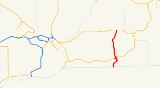
State Route 125 is a state highway
in the U.S. state
of Washington. It extends 23.65 miles (38.06 km) from OR 11 south of Walla Walla
, north to State Route 124
west of Prescott
. SR 125 passes U.S. Route 12
and Walla Walla
. The route serves as a connector from US 12 to SR 124, Prescott
, and Pendleton, Oregon
(via OR 11).
SR 125 was established in 1964 after the 1964 highway renumbering, along its current route. Before SR 125 was established, the route from Oregon to Walla Walla was the Walla Walla branch of Primary State Highway 3 and the route from Walla Walla to Prescott was Secondary State Highway 3E. Even though SR 125 was established in 1964, no signs went up until the law that made SR 125 was approved by the Washington State Legislature
in 1970. SR 125 also has a spur route that connects the highway with U.S. Route 12
eastbound towards Clarkston
. The spur route is located entirely in Walla Walla.
, north to State Route 124
west of Prescott
. The route links the communities of Pendleton, Oregon
(via OR 11), Milton-Freewater, Oregon
(via OR 11), College Place
, Walla Walla
, and Prescott
, and passes Walla Walla College
and Fort Walla Walla
. The road intersects two major arterials: Oregon Route 11 and US 12
before ending at State Route 124.
Starting at the Oregon-Washington border, the route runs north as a four-lane divided highway
into College Place
, where the road becomes undivided and goes northeast into Walla Walla. Within Walla Walla, the route passes the Walla Walla Park and Jefferson Park before turning north to Downtown. In Downtown, SR 125 Spur branches off and SR 125 passes under US 12's divided highway and goes north towards Prescott. The section of SR 125 from Oregon to Walla Walla is the only portion of SR 125 to be part of the National Highway System
.
After leaving Walla Walla, SR 125 goes north to Valley Grove, where the highway starts to parallel the route of the Palouse River and Coulee City Railroad, a railroad that runs from Wallula
to Walla Walla
, Oregon, Waitsburg
, and Dayton
. The highway continues northeast from Valley Grove and passes Hadley, Berryman, and Ennis, before ending at SR 524 approximately 1.3 miles (2.09 km) west of Prescott
.
of SR 125 in Walla Walla
. The route runs from US 12
east to SR 125. The road serves traffic from US 12 eastbound into Walla Walla and connects SR 125 with US 12 eastbound. SR 125 Spur is part of the National Highway System
.
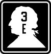 SR 125 became a state highway during the 1964 highway renumbering, in which the Washington State Department of Transportation
(WSDOT) replaced the old system (Primary and Secondary Highways) with a new system (State Routes
), which is still in use today. In the Primary and Secondary system, SR 125 from Oregon to US 12
(then US 410
) was the Walla Walla branch of Primary State Highway 3 and SR 125 from US 12 to SR 124
was Secondary State Highway 3E.
Before and after the establishment, the route of SR 125 has gone through 19 documented WSDOT construction projects from 1921 to 2003. Many were small, minor projects including repavings and intersection improvements. The latest project was a repaving project along SR 125 from Military Road south of Walla Walla to SR 125 Spur. The project cost $1,962,783 USD
and happened in 2003.
State highway
State highway, state road or state route can refer to one of three related concepts, two of them related to a state or provincial government in a country that is divided into states or provinces :#A...
in the U.S. state
U.S. state
A U.S. state is any one of the 50 federated states of the United States of America that share sovereignty with the federal government. Because of this shared sovereignty, an American is a citizen both of the federal entity and of his or her state of domicile. Four states use the official title of...
of Washington. It extends 23.65 miles (38.06 km) from OR 11 south of Walla Walla
Walla Walla, Washington
Walla Walla is the largest city in and the county seat of Walla Walla County, Washington, United States. The population was 31,731 at the 2010 census...
, north to State Route 124
Washington State Route 124
State Route 124 is a state highway in the U.S. state of Washington. It extends from US 12 in Burbank, east to US 12 in Waitsburg. The route serves as a bypass of Walla Walla and as a connector from US 12 to Prescott. SR 124 was established in 1964 after the 1964 highway renumbering, along its...
west of Prescott
Prescott, Washington
Prescott is a town in central Walla Walla County, Washington. The population was 318 at the 2010 census.-History:Prescott was named in 1881 after C.H...
. SR 125 passes U.S. Route 12
U.S. Route 12 in Washington
U.S. Route 12 is a major east-west U.S. Highway, running from Aberdeen, Washington, to Detroit, Michigan. It spans across the state of Washington, and is the only numbered highway to span the entire state from west to east, starting near the Pacific Ocean, and crossing the Idaho state line near...
and Walla Walla
Walla Walla, Washington
Walla Walla is the largest city in and the county seat of Walla Walla County, Washington, United States. The population was 31,731 at the 2010 census...
. The route serves as a connector from US 12 to SR 124, Prescott
Prescott, Washington
Prescott is a town in central Walla Walla County, Washington. The population was 318 at the 2010 census.-History:Prescott was named in 1881 after C.H...
, and Pendleton, Oregon
Pendleton, Oregon
Pendleton is a city in Umatilla County, Oregon, United States. Pendleton was named in 1868 by the county commissioners for George H. Pendleton, Democratic candidate for Vice-President in the 1864 presidential campaign. The population was 16,612 at the 2010 census...
(via OR 11).
SR 125 was established in 1964 after the 1964 highway renumbering, along its current route. Before SR 125 was established, the route from Oregon to Walla Walla was the Walla Walla branch of Primary State Highway 3 and the route from Walla Walla to Prescott was Secondary State Highway 3E. Even though SR 125 was established in 1964, no signs went up until the law that made SR 125 was approved by the Washington State Legislature
Washington State Legislature
The Washington State Legislature is the state legislature of the U.S. state of Washington. It is a bipartisan, bicameral body, composed of the lower Washington House of Representatives, composed of 98 Representatives, and the upper Washington State Senate, with 49 Senators.The State Legislature...
in 1970. SR 125 also has a spur route that connects the highway with U.S. Route 12
U.S. Route 12 in Washington
U.S. Route 12 is a major east-west U.S. Highway, running from Aberdeen, Washington, to Detroit, Michigan. It spans across the state of Washington, and is the only numbered highway to span the entire state from west to east, starting near the Pacific Ocean, and crossing the Idaho state line near...
eastbound towards Clarkston
Clarkston, Washington
Clarkston is a city in Asotin County in the southeastern part of the U.S. state of Washington. It is part of the Lewiston ID-WA Metropolitan Statistical Area. The population was 7,229 in 2010....
. The spur route is located entirely in Walla Walla.
Route description
State Route 125 runs approximately 23.65 miles (38.06 km) from OR 11 south of Walla WallaWalla Walla, Washington
Walla Walla is the largest city in and the county seat of Walla Walla County, Washington, United States. The population was 31,731 at the 2010 census...
, north to State Route 124
Washington State Route 124
State Route 124 is a state highway in the U.S. state of Washington. It extends from US 12 in Burbank, east to US 12 in Waitsburg. The route serves as a bypass of Walla Walla and as a connector from US 12 to Prescott. SR 124 was established in 1964 after the 1964 highway renumbering, along its...
west of Prescott
Prescott, Washington
Prescott is a town in central Walla Walla County, Washington. The population was 318 at the 2010 census.-History:Prescott was named in 1881 after C.H...
. The route links the communities of Pendleton, Oregon
Pendleton, Oregon
Pendleton is a city in Umatilla County, Oregon, United States. Pendleton was named in 1868 by the county commissioners for George H. Pendleton, Democratic candidate for Vice-President in the 1864 presidential campaign. The population was 16,612 at the 2010 census...
(via OR 11), Milton-Freewater, Oregon
Milton-Freewater, Oregon
Milton-Freewater is a city in Umatilla County, Oregon, United States. The city received its current name in 1951 when the neighboring rival cities of Milton and Freewater voted to merge. The population was 6,470 at the 2000 census...
(via OR 11), College Place
College Place, Washington
College Place is a city in Walla Walla County, Washington, United States next to Walla Walla, Washington. The population was 8,765 at the time of the 2010 census.College Place is the home of Walla Walla University, a Seventh-day Adventist college....
, Walla Walla
Walla Walla, Washington
Walla Walla is the largest city in and the county seat of Walla Walla County, Washington, United States. The population was 31,731 at the 2010 census...
, and Prescott
Prescott, Washington
Prescott is a town in central Walla Walla County, Washington. The population was 318 at the 2010 census.-History:Prescott was named in 1881 after C.H...
, and passes Walla Walla College
Walla Walla College
Walla Walla University is a University offering liberal arts, professional, and technical programs located in College Place, Washington, just a few miles from Walla Walla. The current President is John McVay. It was founded in 1892 and is affiliated with the Seventh-day Adventist Church.The...
and Fort Walla Walla
Fort Walla Walla
Fort Walla Walla is a fort located in Walla Walla, Washington. It was established in 1858. Today, the complex contains a park, a museum, and a hospital.Fort Walla Walla should be distinguished from Fort Nez Percés or Old Fort Walla Walla ....
. The road intersects two major arterials: Oregon Route 11 and US 12
U.S. Route 12 in Washington
U.S. Route 12 is a major east-west U.S. Highway, running from Aberdeen, Washington, to Detroit, Michigan. It spans across the state of Washington, and is the only numbered highway to span the entire state from west to east, starting near the Pacific Ocean, and crossing the Idaho state line near...
before ending at State Route 124.
Starting at the Oregon-Washington border, the route runs north as a four-lane divided highway
Divided Highway
Divided Highway is a compilation album by American rock band The Doobie Brothers, released in 2003. . All tracks are taken from the albums Cycles and Brotherhood .-Track listing:...
into College Place
College Place, Washington
College Place is a city in Walla Walla County, Washington, United States next to Walla Walla, Washington. The population was 8,765 at the time of the 2010 census.College Place is the home of Walla Walla University, a Seventh-day Adventist college....
, where the road becomes undivided and goes northeast into Walla Walla. Within Walla Walla, the route passes the Walla Walla Park and Jefferson Park before turning north to Downtown. In Downtown, SR 125 Spur branches off and SR 125 passes under US 12's divided highway and goes north towards Prescott. The section of SR 125 from Oregon to Walla Walla is the only portion of SR 125 to be part of the National Highway System
National Highway System (United States)
The National Highway System is a network of strategic highways within the United States, including the Interstate Highway System and other roads serving major airports, ports, rail or truck terminals, railway stations, pipeline terminals and other strategic transport facilities.Individual states...
.
After leaving Walla Walla, SR 125 goes north to Valley Grove, where the highway starts to parallel the route of the Palouse River and Coulee City Railroad, a railroad that runs from Wallula
Wallula, Washington
Wallula is a census-designated place in Walla Walla County, Washington, United States. The population was 179 at the 2010 census.-History:Lewis and Clark reached the area April 27, 1806, on their return journey from the Pacific...
to Walla Walla
Walla Walla, Washington
Walla Walla is the largest city in and the county seat of Walla Walla County, Washington, United States. The population was 31,731 at the 2010 census...
, Oregon, Waitsburg
Waitsburg, Washington
Waitsburg is a city in Walla Walla County, Washington, United States. The population was 1,217 at the 2010 census. Waitsburg has a unique city classification in the State of Washington. It is the only city which still operates under its territorial charter....
, and Dayton
Dayton, Washington
Dayton is a city in and the county seat of Columbia County, Washington, United States. The population was 2,526 at the 2010 census.-History:...
. The highway continues northeast from Valley Grove and passes Hadley, Berryman, and Ennis, before ending at SR 524 approximately 1.3 miles (2.09 km) west of Prescott
Prescott, Washington
Prescott is a town in central Walla Walla County, Washington. The population was 318 at the 2010 census.-History:Prescott was named in 1881 after C.H...
.
State Route 125 Spur
State Route 125 Spur (SR 125 Spur) is a 0.67 long spur routeSpur route
A spur route is a short road forming a branch from a longer, more important route . A bypass or beltway is never considered a true spur route as it typically reconnects with the major road...
of SR 125 in Walla Walla
Walla Walla, Washington
Walla Walla is the largest city in and the county seat of Walla Walla County, Washington, United States. The population was 31,731 at the 2010 census...
. The route runs from US 12
U.S. Route 12 in Washington
U.S. Route 12 is a major east-west U.S. Highway, running from Aberdeen, Washington, to Detroit, Michigan. It spans across the state of Washington, and is the only numbered highway to span the entire state from west to east, starting near the Pacific Ocean, and crossing the Idaho state line near...
east to SR 125. The road serves traffic from US 12 eastbound into Walla Walla and connects SR 125 with US 12 eastbound. SR 125 Spur is part of the National Highway System
National Highway System (United States)
The National Highway System is a network of strategic highways within the United States, including the Interstate Highway System and other roads serving major airports, ports, rail or truck terminals, railway stations, pipeline terminals and other strategic transport facilities.Individual states...
.
History
Washington State Department of Transportation
The Washington State Department of Transportation , was established in 1905. The agency, led by a Secretary and overseen by the Governor, is a Washington governmental agency that constructs, maintains, and regulates the use of the state's transportation infrastructure...
(WSDOT) replaced the old system (Primary and Secondary Highways) with a new system (State Routes
State highways in Washington
In the U.S. state of Washington, the Washington State Department of Transportation maintains a network of over 7000 miles of state highways, including all Interstate and U.S. Highways that pass through the state. The system comprises 8.5% of the state's public road mileage, but carries over half...
), which is still in use today. In the Primary and Secondary system, SR 125 from Oregon to US 12
U.S. Route 12 in Washington
U.S. Route 12 is a major east-west U.S. Highway, running from Aberdeen, Washington, to Detroit, Michigan. It spans across the state of Washington, and is the only numbered highway to span the entire state from west to east, starting near the Pacific Ocean, and crossing the Idaho state line near...
(then US 410
U.S. Route 410
U.S. Route 410 was one of the west–east state highways. It ran from an intersection with US 101 in Aberdeen, Washington to US 95 in Lewiston, Idaho. The route had concurrencies with SR 8, US 99, and US 395. Even though the number indicates that US 410 was a spur of U.S. Route 10, US 410 never...
) was the Walla Walla branch of Primary State Highway 3 and SR 125 from US 12 to SR 124
Washington State Route 124
State Route 124 is a state highway in the U.S. state of Washington. It extends from US 12 in Burbank, east to US 12 in Waitsburg. The route serves as a bypass of Walla Walla and as a connector from US 12 to Prescott. SR 124 was established in 1964 after the 1964 highway renumbering, along its...
was Secondary State Highway 3E.
Before and after the establishment, the route of SR 125 has gone through 19 documented WSDOT construction projects from 1921 to 2003. Many were small, minor projects including repavings and intersection improvements. The latest project was a repaving project along SR 125 from Military Road south of Walla Walla to SR 125 Spur. The project cost $1,962,783 USD
United States dollar
The United States dollar , also referred to as the American dollar, is the official currency of the United States of America. It is divided into 100 smaller units called cents or pennies....
and happened in 2003.
Major intersections
| County | Location | Mile | Destinations | Notes |
|---|---|---|---|---|
| Walla Walla | 0.00 | Oregon Oregon Oregon is a state in the Pacific Northwest region of the United States. It is located on the Pacific coast, with Washington to the north, California to the south, Nevada on the southeast and Idaho to the east. The Columbia and Snake rivers delineate much of Oregon's northern and eastern... state line |
||
| 0.00 | Southern terminus, continuation as OR 11 | |||
| Walla Walla | 6.08 | |||
| 6.24 | ||||
| 23.65 | Northern terminus | |||