Ynys Gored Goch
Encyclopedia
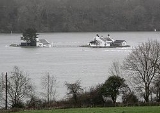
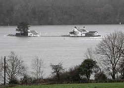
Ynys Gored Goch is a small island in the Menai Strait
between Gwynedd
and Anglesey
in North Wales
. It is situated in the stretch of the strait called the Swellies
between Thomas Telford
's Menai Suspension Bridge
and Robert Stephenson
's Britannia Bridge
.
Most of the island is occupied by a single house and several outbuildings. Access is only by boat.
a year as the island was used as a fishing trap. During high tides fish would swim into the traps set near the island. The catch would then be collected at the subsequent low tide. After 1888 when the house was sold into private hands the whitebait
(herring
), people would often travel to the island to taste the fish.
 The tidal flow
in the Menai Strait around the island is so severe at times that large overfalls and whirlpools develop. This prevents crossings to and from the island for several hours during each tidal cycle. Due to the large tidal range of the Menai Straits the size of the island varies between 0.25 acre
s and 3.7 acre
s.
The height of the sea is known to exceed 10 metres (32.8 ft) during high with spring tides which makes it appears that the building are on two separate islands. When this occurs, the flooding happens. Occasional storm surge
s have even increased water levels up to 11.2 metres (36.7 ft).
Ynys Gored Goch once had a Common Tern
colony although breeding pairs have not been seen on the island recently.
The island's location makes it a popular theme in photographs
of the Menai Straits and its bridges.
Menai Strait
The Menai Strait is a narrow stretch of shallow tidal water about long, which separates the island of Anglesey from the mainland of Wales.The strait is bridged in two places - the main A5 road is carried over the strait by Thomas Telford's elegant iron suspension bridge, the first of its kind,...
between Gwynedd
Gwynedd
Gwynedd is a county in north-west Wales, named after the old Kingdom of Gwynedd. Although the second biggest in terms of geographical area, it is also one of the most sparsely populated...
and Anglesey
Anglesey
Anglesey , also known by its Welsh name Ynys Môn , is an island and, as Isle of Anglesey, a county off the north west coast of Wales...
in North Wales
North Wales
North Wales is the northernmost unofficial region of Wales. It is bordered to the south by the counties of Ceredigion and Powys in Mid Wales and to the east by the counties of Shropshire in the West Midlands and Cheshire in North West England...
. It is situated in the stretch of the strait called the Swellies
Swellies
The Swellies is a stretch of the Menai Strait in North Wales. The most popular use of the name is for the stretch between the Britannia Bridge and the Menai Bridge....
between Thomas Telford
Thomas Telford
Thomas Telford FRS, FRSE was a Scottish civil engineer, architect and stonemason, and a noted road, bridge and canal builder.-Early career:...
's Menai Suspension Bridge
Menai Suspension Bridge
The Menai Suspension Bridge is a suspension bridge between the island of Anglesey and the mainland of Wales. Designed by Thomas Telford and completed in 1826, it was the first modern suspension bridge in the world.-Construction:...
and Robert Stephenson
Robert Stephenson
Robert Stephenson FRS was an English civil engineer. He was the only son of George Stephenson, the famed locomotive builder and railway engineer; many of the achievements popularly credited to his father were actually the joint efforts of father and son.-Early life :He was born on the 16th of...
's Britannia Bridge
Britannia Bridge
Britannia Bridge is a bridge across the Menai Strait between the island of Anglesey and the mainland of Wales. It was originally designed and built by Robert Stephenson as a tubular bridge of wrought iron rectangular box-section spans for carrying rail traffic...
.
Most of the island is occupied by a single house and several outbuildings. Access is only by boat.
History
The earliest known document relating to the island dates from 1590 when it is listed as belonging to the Diocese of Bangor which leased it for £3 and a barrel of herringsHerrings
Herrings may refer to:*Herrings, New York, a village*Herring, a sort of fish...
a year as the island was used as a fishing trap. During high tides fish would swim into the traps set near the island. The catch would then be collected at the subsequent low tide. After 1888 when the house was sold into private hands the whitebait
Whitebait
Whitebait is a collective term for the immature fry of fish, typically between 25 and 50 millimetres long. Such young fish often travel together in schools along the coast, and move into estuaries and sometimes up rivers where they can be easily caught with fine meshed fishing nets...
(herring
Herring
Herring is an oily fish of the genus Clupea, found in the shallow, temperate waters of the North Pacific and the North Atlantic oceans, including the Baltic Sea. Three species of Clupea are recognized. The main taxa, the Atlantic herring and the Pacific herring may each be divided into subspecies...
), people would often travel to the island to taste the fish.
Location

Tidal race
Tidal race is a natural occurrence whereby a fast moving tide passes through a constriction resulting in the formation of waves, eddies and hazardous currents...
in the Menai Strait around the island is so severe at times that large overfalls and whirlpools develop. This prevents crossings to and from the island for several hours during each tidal cycle. Due to the large tidal range of the Menai Straits the size of the island varies between 0.25 acre
Acre
The acre is a unit of area in a number of different systems, including the imperial and U.S. customary systems. The most commonly used acres today are the international acre and, in the United States, the survey acre. The most common use of the acre is to measure tracts of land.The acre is related...
s and 3.7 acre
Acre
The acre is a unit of area in a number of different systems, including the imperial and U.S. customary systems. The most commonly used acres today are the international acre and, in the United States, the survey acre. The most common use of the acre is to measure tracts of land.The acre is related...
s.
The height of the sea is known to exceed 10 metres (32.8 ft) during high with spring tides which makes it appears that the building are on two separate islands. When this occurs, the flooding happens. Occasional storm surge
Storm surge
A storm surge is an offshore rise of water associated with a low pressure weather system, typically tropical cyclones and strong extratropical cyclones. Storm surges are caused primarily by high winds pushing on the ocean's surface. The wind causes the water to pile up higher than the ordinary sea...
s have even increased water levels up to 11.2 metres (36.7 ft).
Ynys Gored Goch once had a Common Tern
Common Tern
The Common Tern is a seabird of the tern family Sternidae. This bird has a circumpolar distribution, breeding in temperate and sub-Arctic regions of Europe, Asia and east and central North America. It is strongly migratory, wintering in coastal tropical and subtropical regions. It is sometimes...
colony although breeding pairs have not been seen on the island recently.
The island's location makes it a popular theme in photographs
Photography
Photography is the art, science and practice of creating durable images by recording light or other electromagnetic radiation, either electronically by means of an image sensor or chemically by means of a light-sensitive material such as photographic film...
of the Menai Straits and its bridges.

