Šolta
Encyclopedia
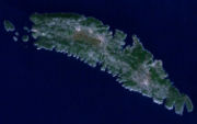
Šolta is an island
in Croatia
. It is situated in the Adriatic Sea
in the central Dalmatia
n archipelago
, west of the island of Brač
, south of Split
(separated by Split Channel
) and east of the Drvenik
islands (separated by the Šolta Channel). Its area is 58.98 km2 and it has a population of 1,675 .
The highest peak of Šolta is the summit Vela Straža which is 238 metres high. On the north-eastern coast of the island there are the large bay
s of Rogač and Nečujam. In the western part of the interior of Šolta there is a field
approximately 6 km long and 2 km wide.
The economy of the island is based on vineyard
s, olive
s, fruit
, fishing
and tourism
. While the main settlements (Grohote, Gornje Selo, Srednje Selo, Donje Selo) are inland, the main fishing centres are Maslinica, which is exposed to only north-westerly winds, making it a good shelter for smaller boats. Rogač is the main port and Nečujam the centre of the island’s tourism.

Island
An island or isle is any piece of sub-continental land that is surrounded by water. Very small islands such as emergent land features on atolls can be called islets, cays or keys. An island in a river or lake may be called an eyot , or holm...
in Croatia
Croatia
Croatia , officially the Republic of Croatia , is a unitary democratic parliamentary republic in Europe at the crossroads of the Mitteleuropa, the Balkans, and the Mediterranean. Its capital and largest city is Zagreb. The country is divided into 20 counties and the city of Zagreb. Croatia covers ...
. It is situated in the Adriatic Sea
Adriatic Sea
The Adriatic Sea is a body of water separating the Italian Peninsula from the Balkan peninsula, and the system of the Apennine Mountains from that of the Dinaric Alps and adjacent ranges...
in the central Dalmatia
Dalmatia
Dalmatia is a historical region on the eastern coast of the Adriatic Sea. It stretches from the island of Rab in the northwest to the Bay of Kotor in the southeast. The hinterland, the Dalmatian Zagora, ranges from fifty kilometers in width in the north to just a few kilometers in the south....
n archipelago
Archipelago
An archipelago , sometimes called an island group, is a chain or cluster of islands. The word archipelago is derived from the Greek ἄρχι- – arkhi- and πέλαγος – pélagos through the Italian arcipelago...
, west of the island of Brač
Brac
Brač is an island in the Adriatic Sea within Croatia, with an area of 396 km², making it the largest island in Dalmatia, and the third largest in the Adriatic. Its tallest peak, Vidova Gora, or Mount St. Vid, stands at 778 m, making it the highest island point in the Adriatic...
, south of Split
Split (city)
Split is a Mediterranean city on the eastern shores of the Adriatic Sea, centered around the ancient Roman Palace of the Emperor Diocletian and its wide port bay. With a population of 178,192 citizens, and a metropolitan area numbering up to 467,899, Split is by far the largest Dalmatian city and...
(separated by Split Channel
Split Channel
The Split Channel |Split]] Gates" or the "Gates of Split"), named after the nearby city of Split, is a narrow passage between the islands of Brač and Šolta in Croatia's Dalmatia region. Situated on the eastern coast of the Adriatic Sea, it is the quickest seaway to the regional capital, Split...
) and east of the Drvenik
Drvenik
Drvenik may mean:* Drvenik - a village in southern Dalmatia, Croatia* Drvenik - a village on island Drvenik veli* Drvenik Veliki and Drvenik Mali - two islands in central Dalmatia, Croatia...
islands (separated by the Šolta Channel). Its area is 58.98 km2 and it has a population of 1,675 .
The highest peak of Šolta is the summit Vela Straža which is 238 metres high. On the north-eastern coast of the island there are the large bay
Bay
A bay is an area of water mostly surrounded by land. Bays generally have calmer waters than the surrounding sea, due to the surrounding land blocking some waves and often reducing winds. Bays also exist as an inlet in a lake or pond. A large bay may be called a gulf, a sea, a sound, or a bight...
s of Rogač and Nečujam. In the western part of the interior of Šolta there is a field
Field (agriculture)
In agriculture, the word field refers generally to an area of land enclosed or otherwise and used for agricultural purposes such as:* Cultivating crops* Usage as a paddock or, generally, an enclosure of livestock...
approximately 6 km long and 2 km wide.
The economy of the island is based on vineyard
Vineyard
A vineyard is a plantation of grape-bearing vines, grown mainly for winemaking, but also raisins, table grapes and non-alcoholic grape juice...
s, olive
Olive
The olive , Olea europaea), is a species of a small tree in the family Oleaceae, native to the coastal areas of the eastern Mediterranean Basin as well as northern Iran at the south end of the Caspian Sea.Its fruit, also called the olive, is of major agricultural importance in the...
s, fruit
Fruit
In broad terms, a fruit is a structure of a plant that contains its seeds.The term has different meanings dependent on context. In non-technical usage, such as food preparation, fruit normally means the fleshy seed-associated structures of certain plants that are sweet and edible in the raw state,...
, fishing
Fishing
Fishing is the activity of trying to catch wild fish. Fish are normally caught in the wild. Techniques for catching fish include hand gathering, spearing, netting, angling and trapping....
and tourism
Tourism
Tourism is travel for recreational, leisure or business purposes. The World Tourism Organization defines tourists as people "traveling to and staying in places outside their usual environment for not more than one consecutive year for leisure, business and other purposes".Tourism has become a...
. While the main settlements (Grohote, Gornje Selo, Srednje Selo, Donje Selo) are inland, the main fishing centres are Maslinica, which is exposed to only north-westerly winds, making it a good shelter for smaller boats. Rogač is the main port and Nečujam the centre of the island’s tourism.
External links


