
2005 Pacific hurricane season
Encyclopedia
The 2005 Pacific hurricane season officially began on May 15, 2005 in the eastern Pacific and on June 1, 2005 in the central Pacific, and lasted until November 30, 2005. These dates conventionally delimit the period of each year when most tropical cyclones form in the northeastern Pacific Ocean. The season got off to a quick start, with the tropical depression that would become Hurricane Adrian
forming just two days into the season on May 17. It took a very rare track skirting El Salvador
as a Category 1 hurricane then striking Honduras
as a tropical depression. Between June and September, Dora was the only storm that posed a significant threat to land as it skirted the Mexican coast
, and Kenneth
came close to Hawaii
as a dissipating tropical depression. Hurricane Otis appeared to be heading for an encounter with the Baja California peninsula
, but turned north-northwest, paralleling the coast, before dissipating.

The U.S.
National Oceanic and Atmospheric Administration
predicted a slow year, with only a 10% chance of above-average storm activity in the eastern North Pacific and a 70% chance of below-normal activity. The pre-season forecast predicted 11 to 15 tropical storms, 6 to 8 hurricanes, and 2 to 4 major hurricanes (Category 3 or higher on the Saffir-Simpson Hurricane Scale).
The forecast for the central North Pacific was for a below-average season, with only two or three storms impacting the region, below the normal four to five.
than any other hurricane
in the 57 years of known storms in the eastern Pacific basin
. Adrian developed out of an area of disturbed weather on May 10 over Central America
. A broad area of low pressure
developed out of the disturbance while located 520 mi (835 km) south-southeast of Acapulco, Mexico on May 14. The low was nearly stationary as convection
around it developed. A weak tropical wave
crossed over Central America the next day and was absorbed into the broad low pressure system. This led to further development of convection around the storm. The low gradually became better organized and was determined to have become a tropical depression on the afternoon of May 17. An unusually strong mid to upper-level trough
was situated over southwestern Mexico, leading to the depression traveling towards the northeast, rather than the usual northwest movement. The depression quickly intensified into the first tropical storm of the season that night and was named Adrian. Adrian gradually intensified over the next two days as it continued towards the northeast. Moderate southwesterly wind shear
prevented the storms' convective bands to remain with the system. This led to the convection associated with the storm to contract as the storm intensified. On the afternoon of May 19, Adrian briefly intensified into a hurricane, with peak winds reaching 80 mph (130 km/h) while located 85 mi (135 km) southwest of the coast of El Salvador. Operationally, Adrian was assessed to have made landfall late that night as a minimal hurricane, but post season analysis showed that the persistent southwesterly wind shear and the proximity to the mountains of Central America caused Adrian to rapidly deteriorate as it approached land, and the storm never actually made landfall in El Salvador. The mid and low-level circulations of Adrian split, the mid-level circulation moved into El Salvador, but the low-level circulation continued moving towards the east-northeast. Adrian eventually made landfall as a tropical depression, near the Gulf of Fonseca
in Honduras
on the morning of May 20. The storm dissipated shortly after moving inland.
Since Adrian rapidly weakened before making landfall, there was minimal wind damage but heavy rainfall fell across much of El Salvador, Honduras, Nicaragua
, and Guatemala
leading to flooding. One fatality was attributed to Adrian; a person drowned in floodwaters in Nicaragua.
in 2003, Beatriz formed 280 miles (445 km) south of the Mexican
port of Zihuatanejo
, Guerrero
, on June 21, reaching tropical storm strength the next day, with winds peaking around 50 mph (80 km/h) on June 23. It slowly moved west and dissipated into a remnant low on the morning of June 24 about 290 miles (470 km) from Cabo San Lucas
on the southern tip of the Baja California Peninsula
, having never threatened land.
early on June 26, and reached tropical storm strength and was named Calvin late that day. Tropical storm watches
were issued for the southern coast of Mexico around Acapulco
as Calvin slowly moved westward, with windspeeds peaking at 50 mph (80 km/h) on June 27, but all watches were cancelled on the morning of June 28 as it moved away from the coast. Calvin weakened to a tropical depression later that day, and lost tropical characteristics that night.
port of Acapulco
, Guerrero
. Watches and warnings were issued as it neared the Mexican coast. On the afternoon of July 4, the depression strengthened into a tropical storm while located about 45 miles (75 km) west-southwest of Acapulco. It came within miles of the coast, moving somewhat parallel to it on July 4, dropping heavy rainfall on the region. As it moved away from the coast, all watches were cancelled as it dropped to a tropical depression midday on July 5, finally dissipating early on July 6.
. Tropical storm watches
were issued for the area around Cabo San Lucas
for most of the day, but the storm moved away without affecting land.
on August 3, a month later than the first (and only) central system to develop in 2004. It began a track due west, which could have put it within range of the island of Oahu, Hawaii, a few days later. It was initially forecast to strengthen into a tropical storm (one had not formed in the central Pacific since Huko in the 2002 season
). However, the next day's models changed to indicate no further increase in strength. Shortly after that, convection bursts ceased and the system lost its closed circulation while still 725 miles (1200 km) from Hilo.
in the Mexican state of Baja California Sur
on August 9. It was upgraded to Tropical Storm Fernanda late that day, and to Hurricane Fernanda on August 11, as it headed generally west-northwest into the open Pacific. On August 14 it dropped to tropical storm strength over cooler waters and on August 15 weakened to a tropical depression. It degenerated into a remnant low later in the day about 1650 miles (2,655.4 km) southwest of the southern tip of the Baja California Peninsula
.
on August 11, and was upgraded to Tropical Storm Greg a few hours later. Although only 750 miles (1200 km) from Hurricane Fernanda it showed no signs of being pushed northwards by interaction, but set off westwards to follow Fernanda into the Pacific. Greg was downgraded to tropical depression status on August 14 and remained stationary throughout the day. It began drifting slowly westward early on August 15 and was destroyed by shear later in the day.
on August 4. The wave initially had a large area of deep convention, but the convention quickly diminished as the system moved across the eastern portion of the tropical Atlantic Ocean. The wave continued westward without much development or organization, and crossed northern South America
and then entered the northern Pacific Ocean
on August 17. Mid-level circulation and convention organized with the wave, as it was south of Guatemala
on August 18. The system's organization persisted, but without defining a well-established center of circulation, at the surface.
Tropical Depression Eight-E finally formed from the area of disturbed weather south of the Gulf of Tehuantepec
, 140 miles (225.3 km) south of Puerto Angel, Mexico
, on August 19. It strengthened to a tropical storm late that evening, and reached hurricane strength 24 hours later. Moving parallel to the Mexican
coast and about 300 miles (482.8 km) off-shore, it reached Category 2 on the Saffir-Simpson Hurricane Scale
late on August 21. Tropical storm winds affected the coast and a tropical storm warning
was issued for a while. Hilary dissipated not long after weakening to a tropical storm on August 25.
port of Manzanillo
, Colima
on August 25, out of a remnant wave that split from Atlantic Tropical Depression Ten (the other part of the wave would eventually develop into Hurricane Katrina
) that crossed Central America
. The depression strengthened to Tropical Storm Irwin early the next day, reaching wind speeds of 50 mph (85 km/h). Although Irwin headed almost due west over warm water, it encountered shear, soon weakened and dissipated on August 28.
and headed almost due west. Late on September 14, the depression strengthened and was upgraded to tropical storm status. It strengthened further to hurricane status early on September 16. On September 18 it crossed meridian
140°W
, becoming the first hurricane in about three years to be in the forecast area of the Central Pacific Hurricane Center
. Jova soon strengthened to a major hurricane, the first one to exist in the Central Pacific since Ele in 2002
. It weakened as it steered to the northeast of Hawai'i
, weakening to a tropical storm on September 22 and to a tropical depression on September 23 before finally dissipating on September 24.
when it formed just 600 miles (965.6 km) east of Depression Ten-E. It found more favorable conditions than its western neighbor, and was upgraded to Tropical Storm Kenneth just 12 hours after forming. Kenneth strengthened into a hurricane later that day and continued to strengthen very rapidly, becoming the first major hurricane of the season by reaching Category 3 on September 17. The storm became the strongest storm to form this season in the Eastern Pacific when Kenneth peaked with sustained winds of 135 mi/h, Category 4 on the Saffir Simpson Hurricane Scale. Kenneth began gradually weakening on September 19, and weakened to a tropical storm on September 20. However, Kenneth gained enough strength to be reclassified as a Category 1
hurricane on September 24, and very late on September 25 it crossed 140°W
, making it the second hurricane of the season to enter the Central Pacific. It then dropped back again to a tropical storm, and weakened to a tropical depression on September 29 less than 400 miles (643.7 km) east of Hawai‘i
. It came within 50 miles (80.5 km) of the Big Island
of Hawaii before degenerating into an open wave. No tropical cyclone has made landfall on Hawai‘i since Tropical Depression Eugene in the 1993 season
. 6-12 inches of rain was reported on portions of Hawaii.
n coast at the end of August showed some hints of development while crossing the Atlantic but never developed a tropical circulation there. After crossing the Isthmus of Tehuantepec
into the Pacific it acquired better organisation, and became Tropical Depression Twelve-E on September 17. It was the third depression in quick succession to form well south-southwest of the Baja California Peninsula
, and did so less than 800 miles (1,287.5 km) east of Hurricane Kenneth. It strengthened to Tropical Storm Lidia later the same day, but the next day was pushed off its course and weakened by the new and larger Tropical Depression Thirteen-E, which became Tropical Storm Max. On September 18, Lidia was completely absorbed by the circulation of Max.
on September 18. It was sufficiently close to Lidia that it blew the earlier, weaker storm rapidly to the north. It strengthened to Tropical Storm Max within a few hours, and absorbed the remnants of Tropical Depression Lidia. On late September 19 the tropical storm was upgraded to Hurricane Max. The system began to weaken almost immediately thereafter, however, and Max dissipated in the early morning hours of September 22.
The merging of two tropical cyclones or the absorption of one tropical cyclone by another are uncommon events in the National Hurricane Center's area of responsibility. The last documented case of such an occurrence in the eastern North Pacific was when Hurricane Gil absorbed Tropical Storm Henriette in September 2001.
. Tropical Depression Fourteen-E formed on 10:00 p.m September 21, while located about 402 miles (650 km) southwest of Manzanillo. Four hours later, it intensified into Tropical storm Norma. During that time, the storm's convection increased near its center.
On September 24, Norma continued to slowly move in a northwestward direction from 8:00 a.m. to 2:00 p.m. PDT. Around mid-day some banding features also developed and the storm's center became more embedded within the convection; it reached a peak intensity of 55 mph (90 km/h). Easterly wind shear
caused a decrease in the storm's organization later on September 24, generally weakening the convection. The center was then exposed from the convective activity by northwest winds early on September 25, and the storm's intensity was reduced. The sheared system began to gradually weaken as the center was located near the northeastern edge of poorly-organized deep convection. Norma was downgraded to a tropical depression on September 26 at 1800 UTC.
port of Manzanillo
, Colima
, on September 28 out of an Atlantic wave that crossed into the Pacific (split off from what would become Hurricane Philippe
in the Atlantic). Twenty four hours later it was upgraded to Tropical Storm Otis. Early on September 30 it was upgraded to a hurricane, and it reached Category 2 on October 1 with 105 mph (170 km/h) winds before weakening again as it drifted very slowly northwards. On October 2 it took a north-northwesterly turn, moving away from the Baja California peninsula, and instead paralleling the coast, before being downgraded to a depression. The NHC ceased advisories on Otis at 21:00 UTC the next day.
Although the center of Otis remained offshore, tropical storm-force winds were reported at higher elevations over portions of southern Baja California. At Cabo San Lucas, an automated weather station recorded a wind gust to 63 mph (101.4 km/h) on September 30, with sustained winds of 49 mph (78.9 km/h). There, periods of heavy rainfall mixed with fair skies as the storm passed. No damages or fatalities were reported, although some media reports indicated that the storm caused flooding in parts of the southern Baja California peninsula. Offshore, two ships reported tropical-storm-force winds in association with the storm: the Volendam on October 3, and the Star Harmonia on October 1. As the damage was not severe, the name "Otis" was not retired, and remains on the list of names to be used during the 2011 season. The name was previously used in 1981
and 1987
.
, Guerrero
, late on October 14. Although initial forecasts expected it to strengthen, the depression never gained enough organisation to become a tropical storm and instead appeared to dissipate. Advisories were discontinued on October 18, but resumed on October 19 when the remnant low pressure area regenerated deep convection. The system still struggled to develop, apparently due to the entrainment of relatively dry air inhibiting sustained convection. The second final advisory was issued at 2 p.m. PDT (2100 UTC) October 20. The remnant was absorbed into the Intertropical Convergence Zone
(ITCZ) the next day.
. Names that were not assigned are marked in gray. There were no names retired by the WMO
in the spring of 2006; therefore, the same list was reused in the 2011 season
.
No central Pacific names were used; the first name used would have been Ioke.
Hurricane Adrian (2005)
Hurricane Adrian was an early season hurricane which took an unusual southwest to northeast track, bringing it closer to El Salvador than any other hurricane since reliable records began in 1949. The first storm of the 2005 Pacific hurricane season, Adrian developed on May 17, just two days...
forming just two days into the season on May 17. It took a very rare track skirting El Salvador
El Salvador
El Salvador or simply Salvador is the smallest and the most densely populated country in Central America. The country's capital city and largest city is San Salvador; Santa Ana and San Miguel are also important cultural and commercial centers in the country and in all of Central America...
as a Category 1 hurricane then striking Honduras
Honduras
Honduras is a republic in Central America. It was previously known as Spanish Honduras to differentiate it from British Honduras, which became the modern-day state of Belize...
as a tropical depression. Between June and September, Dora was the only storm that posed a significant threat to land as it skirted the Mexican coast
Mexico
The United Mexican States , commonly known as Mexico , is a federal constitutional republic in North America. It is bordered on the north by the United States; on the south and west by the Pacific Ocean; on the southeast by Guatemala, Belize, and the Caribbean Sea; and on the east by the Gulf of...
, and Kenneth
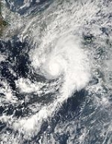
Hurricane Kenneth (2005)
Hurricane Kenneth was the strongest and longest-tracked hurricane of the 2005 Pacific hurricane season. The eleventh named storm and fifth hurricane of the season, Kenneth developed from a disturbance in the Intertropical Convergence Zone to the southwest of Mexico on September 14...
came close to Hawaii
Hawaii
Hawaii is the newest of the 50 U.S. states , and is the only U.S. state made up entirely of islands. It is the northernmost island group in Polynesia, occupying most of an archipelago in the central Pacific Ocean, southwest of the continental United States, southeast of Japan, and northeast of...
as a dissipating tropical depression. Hurricane Otis appeared to be heading for an encounter with the Baja California peninsula
Baja California Peninsula
The Baja California peninsula , is a peninsula in northwestern Mexico. Its land mass separates the Pacific Ocean from the Gulf of California. The Peninsula extends from Mexicali, Baja California in the north to Cabo San Lucas, Baja California Sur in the south.The total area of the Baja California...
, but turned north-northwest, paralleling the coast, before dissipating.
Pre-season forecasts
| Source | Date | b>Named storms |
b>Hurricanes | b>Major hurricanes |
| Eastern | Average | 15.3 | 8.8 | 4.2 |
| Eastern | 16 May 2005 | 11 – 15 | 6 – 8 | 2 – 4 |
| Eastern | Actual activity | 15 | 7 | 2 |
| Central | Average | 4 – 5 | 1 | - |
| Central | May 16, 2005 | 2 – 3 | - | - |
| Central | Actual activity | 2 | 2 | 1 |
The U.S.
United States
The United States of America is a federal constitutional republic comprising fifty states and a federal district...
National Oceanic and Atmospheric Administration
National Oceanic and Atmospheric Administration
The National Oceanic and Atmospheric Administration , pronounced , like "noah", is a scientific agency within the United States Department of Commerce focused on the conditions of the oceans and the atmosphere...
predicted a slow year, with only a 10% chance of above-average storm activity in the eastern North Pacific and a 70% chance of below-normal activity. The pre-season forecast predicted 11 to 15 tropical storms, 6 to 8 hurricanes, and 2 to 4 major hurricanes (Category 3 or higher on the Saffir-Simpson Hurricane Scale).
The forecast for the central North Pacific was for a below-average season, with only two or three storms impacting the region, below the normal four to five.
Hurricane Adrian
Hurricane Adrian was an early season hurricane which took an unusual southwest to northeast track, bringing it closer to El SalvadorEl Salvador
El Salvador or simply Salvador is the smallest and the most densely populated country in Central America. The country's capital city and largest city is San Salvador; Santa Ana and San Miguel are also important cultural and commercial centers in the country and in all of Central America...
than any other hurricane
Tropical cyclone
A tropical cyclone is a storm system characterized by a large low-pressure center and numerous thunderstorms that produce strong winds and heavy rain. Tropical cyclones strengthen when water evaporated from the ocean is released as the saturated air rises, resulting in condensation of water vapor...
in the 57 years of known storms in the eastern Pacific basin
Pacific hurricane
A Pacific hurricane or tropical storm is a tropical cyclone that develops in the northeastern part of the Pacific Ocean. For organizational purposes, the northern Pacific Ocean is divided into three regions: the eastern, , central , and western...
. Adrian developed out of an area of disturbed weather on May 10 over Central America
Central America
Central America is the central geographic region of the Americas. It is the southernmost, isthmian portion of the North American continent, which connects with South America on the southeast. When considered part of the unified continental model, it is considered a subcontinent...
. A broad area of low pressure
Low pressure area
A low-pressure area, or "low", is a region where the atmospheric pressure at sea level is below that of surrounding locations. Low-pressure systems form under areas of wind divergence which occur in upper levels of the troposphere. The formation process of a low-pressure area is known as...
developed out of the disturbance while located 520 mi (835 km) south-southeast of Acapulco, Mexico on May 14. The low was nearly stationary as convection
Atmospheric convection
Atmospheric convection is the result of a parcel-environment instability, or temperature difference, layer in the atmosphere. Different lapse rates within dry and moist air lead to instability. Mixing of air during the day which expands the height of the planetary boundary layer leads to...
around it developed. A weak tropical wave
Tropical wave
Tropical waves, easterly waves, or tropical easterly waves, also known as African easterly waves in the Atlantic region, are a type of atmospheric trough, an elongated area of relatively low air pressure, oriented north to south, which move from east to west across the tropics causing areas of...
crossed over Central America the next day and was absorbed into the broad low pressure system. This led to further development of convection around the storm. The low gradually became better organized and was determined to have become a tropical depression on the afternoon of May 17. An unusually strong mid to upper-level trough
Trough (meteorology)
A trough is an elongated region of relatively low atmospheric pressure, often associated with fronts.Unlike fronts, there is not a universal symbol for a trough on a weather chart. The weather charts in some countries or regions mark troughs by a line. In the United States, a trough may be marked...
was situated over southwestern Mexico, leading to the depression traveling towards the northeast, rather than the usual northwest movement. The depression quickly intensified into the first tropical storm of the season that night and was named Adrian. Adrian gradually intensified over the next two days as it continued towards the northeast. Moderate southwesterly wind shear
Wind shear
Wind shear, sometimes referred to as windshear or wind gradient, is a difference in wind speed and direction over a relatively short distance in the atmosphere...
prevented the storms' convective bands to remain with the system. This led to the convection associated with the storm to contract as the storm intensified. On the afternoon of May 19, Adrian briefly intensified into a hurricane, with peak winds reaching 80 mph (130 km/h) while located 85 mi (135 km) southwest of the coast of El Salvador. Operationally, Adrian was assessed to have made landfall late that night as a minimal hurricane, but post season analysis showed that the persistent southwesterly wind shear and the proximity to the mountains of Central America caused Adrian to rapidly deteriorate as it approached land, and the storm never actually made landfall in El Salvador. The mid and low-level circulations of Adrian split, the mid-level circulation moved into El Salvador, but the low-level circulation continued moving towards the east-northeast. Adrian eventually made landfall as a tropical depression, near the Gulf of Fonseca
Gulf of Fonseca
The Gulf of Fonseca , part of the Pacific Ocean, is a gulf in Central America, bordering El Salvador, Honduras and Nicaragua.-History:Fonseca Bay was discovered in 1522 by Gil Gonzalez de Avila, and named by him after his patron, Archbishop Juan Fonseca, the implacable enemy of Columbus.In 1849, E. G...
in Honduras
Honduras
Honduras is a republic in Central America. It was previously known as Spanish Honduras to differentiate it from British Honduras, which became the modern-day state of Belize...
on the morning of May 20. The storm dissipated shortly after moving inland.
Since Adrian rapidly weakened before making landfall, there was minimal wind damage but heavy rainfall fell across much of El Salvador, Honduras, Nicaragua
Nicaragua
Nicaragua is the largest country in the Central American American isthmus, bordered by Honduras to the north and Costa Rica to the south. The country is situated between 11 and 14 degrees north of the Equator in the Northern Hemisphere, which places it entirely within the tropics. The Pacific Ocean...
, and Guatemala
Guatemala
Guatemala is a country in Central America bordered by Mexico to the north and west, the Pacific Ocean to the southwest, Belize to the northeast, the Caribbean to the east, and Honduras and El Salvador to the southeast...
leading to flooding. One fatality was attributed to Adrian; a person drowned in floodwaters in Nicaragua.
- The NHCNational Hurricane CenterThe National Hurricane Center , located at Florida International University in Miami, Florida, is the division of the National Weather Service responsible for tracking and predicting weather systems within the tropics between the Prime Meridian and the 140th meridian west poleward to the 30th...
's archive on Hurricane Adrian. - The NHCNational Hurricane CenterThe National Hurricane Center , located at Florida International University in Miami, Florida, is the division of the National Weather Service responsible for tracking and predicting weather systems within the tropics between the Prime Meridian and the 140th meridian west poleward to the 30th...
's Tropical Cyclone Report on Hurricane Adrian.
Tropical Storm Beatriz
The first tropical storm to form in the Eastern Pacific in June since CarlosTropical Storm Carlos (2003)
Tropical Storm Carlos was the first of five tropical cyclones to make landfall during the 2003 Pacific hurricane season. It formed on June 26 from a tropical wave to the south of Mexico. It quickly strengthened as it approached the coast, and early on June 27 Carlos moved ashore in Oaxaca...
in 2003, Beatriz formed 280 miles (445 km) south of the Mexican
Mexico
The United Mexican States , commonly known as Mexico , is a federal constitutional republic in North America. It is bordered on the north by the United States; on the south and west by the Pacific Ocean; on the southeast by Guatemala, Belize, and the Caribbean Sea; and on the east by the Gulf of...
port of Zihuatanejo
Zihuatanejo
Zihuatanejo or Ixtapa-Zihuatanejo, is the fourth-largest city in the Mexican state of Guerrero. Politically the city belongs to the municipality of Zihuatanejo de Azueta in the western part of Guerrero, but both are commonly referred to as Zihuatanejo...
, Guerrero
Guerrero
Guerrero officially Estado Libre y Soberano de Guerrero is one of the 31 states which, with the Federal District, comprise the 32 Federal Entities of Mexico. It is divided in 81 municipalities and its capital city is Chilpancingo....
, on June 21, reaching tropical storm strength the next day, with winds peaking around 50 mph (80 km/h) on June 23. It slowly moved west and dissipated into a remnant low on the morning of June 24 about 290 miles (470 km) from Cabo San Lucas
Cabo San Lucas
Cabo San Lucas , commonly called Cabo, is a city at the southern tip of the Baja California peninsula, in the municipality of Los Cabos in the Mexican state of Baja California Sur. As of the 2010 census, the population was 68,463 people...
on the southern tip of the Baja California Peninsula
Baja California Peninsula
The Baja California peninsula , is a peninsula in northwestern Mexico. Its land mass separates the Pacific Ocean from the Gulf of California. The Peninsula extends from Mexicali, Baja California in the north to Cabo San Lucas, Baja California Sur in the south.The total area of the Baja California...
, having never threatened land.
- The NHCNational Hurricane CenterThe National Hurricane Center , located at Florida International University in Miami, Florida, is the division of the National Weather Service responsible for tracking and predicting weather systems within the tropics between the Prime Meridian and the 140th meridian west poleward to the 30th...
's archive on Tropical Storm Beatriz. - The NHCNational Hurricane CenterThe National Hurricane Center , located at Florida International University in Miami, Florida, is the division of the National Weather Service responsible for tracking and predicting weather systems within the tropics between the Prime Meridian and the 140th meridian west poleward to the 30th...
's Tropical Cyclone Report on Tropical Storm Beatriz.
Tropical Storm Calvin
Tropical Depression Three-E formed just south of MexicoMexico
The United Mexican States , commonly known as Mexico , is a federal constitutional republic in North America. It is bordered on the north by the United States; on the south and west by the Pacific Ocean; on the southeast by Guatemala, Belize, and the Caribbean Sea; and on the east by the Gulf of...
early on June 26, and reached tropical storm strength and was named Calvin late that day. Tropical storm watches
Tropical cyclone warnings and watches
Warnings and watches are two levels of alert issued by national weather forecasting bodies to coastal areas threatened by the imminent approach of a tropical cyclone of tropical storm or hurricane intensity. They are notices to the local population and civil authorities to make appropriate...
were issued for the southern coast of Mexico around Acapulco
Acapulco
Acapulco is a city, municipality and major sea port in the state of Guerrero on the Pacific coast of Mexico, southwest from Mexico City. Acapulco is located on a deep, semi-circular bay and has been a port since the early colonial period of Mexico’s history...
as Calvin slowly moved westward, with windspeeds peaking at 50 mph (80 km/h) on June 27, but all watches were cancelled on the morning of June 28 as it moved away from the coast. Calvin weakened to a tropical depression later that day, and lost tropical characteristics that night.
- The NHCNational Hurricane CenterThe National Hurricane Center , located at Florida International University in Miami, Florida, is the division of the National Weather Service responsible for tracking and predicting weather systems within the tropics between the Prime Meridian and the 140th meridian west poleward to the 30th...
's archive on Tropical Storm Calvin. - The NHCNational Hurricane CenterThe National Hurricane Center , located at Florida International University in Miami, Florida, is the division of the National Weather Service responsible for tracking and predicting weather systems within the tropics between the Prime Meridian and the 140th meridian west poleward to the 30th...
's Tropical Cyclone Report on Tropical Storm Calvin.
Tropical Storm Dora
An active early season continued with Tropical Depression Four-E forming on July 3 from a tropical wave south of the MexicanMexico
The United Mexican States , commonly known as Mexico , is a federal constitutional republic in North America. It is bordered on the north by the United States; on the south and west by the Pacific Ocean; on the southeast by Guatemala, Belize, and the Caribbean Sea; and on the east by the Gulf of...
port of Acapulco
Acapulco
Acapulco is a city, municipality and major sea port in the state of Guerrero on the Pacific coast of Mexico, southwest from Mexico City. Acapulco is located on a deep, semi-circular bay and has been a port since the early colonial period of Mexico’s history...
, Guerrero
Guerrero
Guerrero officially Estado Libre y Soberano de Guerrero is one of the 31 states which, with the Federal District, comprise the 32 Federal Entities of Mexico. It is divided in 81 municipalities and its capital city is Chilpancingo....
. Watches and warnings were issued as it neared the Mexican coast. On the afternoon of July 4, the depression strengthened into a tropical storm while located about 45 miles (75 km) west-southwest of Acapulco. It came within miles of the coast, moving somewhat parallel to it on July 4, dropping heavy rainfall on the region. As it moved away from the coast, all watches were cancelled as it dropped to a tropical depression midday on July 5, finally dissipating early on July 6.
- The NHCNational Hurricane CenterThe National Hurricane Center , located at Florida International University in Miami, Florida, is the division of the National Weather Service responsible for tracking and predicting weather systems within the tropics between the Prime Meridian and the 140th meridian west poleward to the 30th...
's archive on Tropical Storm Dora. - The NHCNational Hurricane CenterThe National Hurricane Center , located at Florida International University in Miami, Florida, is the division of the National Weather Service responsible for tracking and predicting weather systems within the tropics between the Prime Meridian and the 140th meridian west poleward to the 30th...
's Tropical Cyclone Report on Tropical Storm Dora.
Tropical Storm Eugene
Eugene formed from a tropical disturbance off the central Mexican coast on July 18 and headed northwest, one of the few cyclones to reach tropical storm-strength without being designated as a tropical depression. Initially, as with most Eastern Pacific storms, no public advisories or warnings were issued, since it was heading out to sea. However, on July 19 it came within range of the southern tip of the Baja California peninsulaBaja California Peninsula
The Baja California peninsula , is a peninsula in northwestern Mexico. Its land mass separates the Pacific Ocean from the Gulf of California. The Peninsula extends from Mexicali, Baja California in the north to Cabo San Lucas, Baja California Sur in the south.The total area of the Baja California...
. Tropical storm watches
Tropical cyclone warnings and watches
Warnings and watches are two levels of alert issued by national weather forecasting bodies to coastal areas threatened by the imminent approach of a tropical cyclone of tropical storm or hurricane intensity. They are notices to the local population and civil authorities to make appropriate...
were issued for the area around Cabo San Lucas
Cabo San Lucas
Cabo San Lucas , commonly called Cabo, is a city at the southern tip of the Baja California peninsula, in the municipality of Los Cabos in the Mexican state of Baja California Sur. As of the 2010 census, the population was 68,463 people...
for most of the day, but the storm moved away without affecting land.
- The NHCNational Hurricane CenterThe National Hurricane Center , located at Florida International University in Miami, Florida, is the division of the National Weather Service responsible for tracking and predicting weather systems within the tropics between the Prime Meridian and the 140th meridian west poleward to the 30th...
's archive on Tropical Storm Eugene. - The NHCNational Hurricane CenterThe National Hurricane Center , located at Florida International University in Miami, Florida, is the division of the National Weather Service responsible for tracking and predicting weather systems within the tropics between the Prime Meridian and the 140th meridian west poleward to the 30th...
's Tropical Cyclone Report on Tropical Storm Eugene.
Tropical Depression One-C
The first tropical system in the central Pacific formed east-southeast of HawaiiHawaii
Hawaii is the newest of the 50 U.S. states , and is the only U.S. state made up entirely of islands. It is the northernmost island group in Polynesia, occupying most of an archipelago in the central Pacific Ocean, southwest of the continental United States, southeast of Japan, and northeast of...
on August 3, a month later than the first (and only) central system to develop in 2004. It began a track due west, which could have put it within range of the island of Oahu, Hawaii, a few days later. It was initially forecast to strengthen into a tropical storm (one had not formed in the central Pacific since Huko in the 2002 season
2002 Pacific hurricane season
The 2002 Pacific hurricane season was an event in tropical cyclone meteorology. The most notable storm that year was Hurricane Kenna, which reached Category 5 on the Saffir-Simpson Hurricane Scale. It made landfall near Puerto Vallarta, in the Mexican state of Jalisco, on October 25...
). However, the next day's models changed to indicate no further increase in strength. Shortly after that, convection bursts ceased and the system lost its closed circulation while still 725 miles (1200 km) from Hilo.
- The CPHCCentral Pacific Hurricane CenterThe Central Pacific Hurricane Center of the United States National Weather Service is the official body responsible for tracking and issuing tropical cyclone warnings, watches, advisories, discussions, and statements for the Central North Pacific Basin...
's summary of Tropical Depression One-C.
Hurricane Fernanda
Tropical Depression Six-E formed from an area of disturbed weather some 690 miles (1100 km) south-southwest of Cabo San LucasCabo San Lucas
Cabo San Lucas , commonly called Cabo, is a city at the southern tip of the Baja California peninsula, in the municipality of Los Cabos in the Mexican state of Baja California Sur. As of the 2010 census, the population was 68,463 people...
in the Mexican state of Baja California Sur
Baja California Sur
Baja California Sur , is one of the 31 states which, with the Federal District, comprise the 32 Federal Entities of Mexico. Before becoming a state on October 8, 1974, the area was known as the South Territory of Baja California. It has an area of , or 3.57% of the land mass of Mexico and comprises...
on August 9. It was upgraded to Tropical Storm Fernanda late that day, and to Hurricane Fernanda on August 11, as it headed generally west-northwest into the open Pacific. On August 14 it dropped to tropical storm strength over cooler waters and on August 15 weakened to a tropical depression. It degenerated into a remnant low later in the day about 1650 miles (2,655.4 km) southwest of the southern tip of the Baja California Peninsula
Baja California Peninsula
The Baja California peninsula , is a peninsula in northwestern Mexico. Its land mass separates the Pacific Ocean from the Gulf of California. The Peninsula extends from Mexicali, Baja California in the north to Cabo San Lucas, Baja California Sur in the south.The total area of the Baja California...
.
- The NHCNational Hurricane CenterThe National Hurricane Center , located at Florida International University in Miami, Florida, is the division of the National Weather Service responsible for tracking and predicting weather systems within the tropics between the Prime Meridian and the 140th meridian west poleward to the 30th...
's archive on Hurricane Fernanda. - The NHCNational Hurricane CenterThe National Hurricane Center , located at Florida International University in Miami, Florida, is the division of the National Weather Service responsible for tracking and predicting weather systems within the tropics between the Prime Meridian and the 140th meridian west poleward to the 30th...
's Tropical Cyclone Report on Hurricane Fernanda.
Tropical Storm Greg
Tropical Depression Seven-E formed 670 miles (1100 km) south of Cabo San LucasCabo San Lucas
Cabo San Lucas , commonly called Cabo, is a city at the southern tip of the Baja California peninsula, in the municipality of Los Cabos in the Mexican state of Baja California Sur. As of the 2010 census, the population was 68,463 people...
on August 11, and was upgraded to Tropical Storm Greg a few hours later. Although only 750 miles (1200 km) from Hurricane Fernanda it showed no signs of being pushed northwards by interaction, but set off westwards to follow Fernanda into the Pacific. Greg was downgraded to tropical depression status on August 14 and remained stationary throughout the day. It began drifting slowly westward early on August 15 and was destroyed by shear later in the day.
- The NHCNational Hurricane CenterThe National Hurricane Center , located at Florida International University in Miami, Florida, is the division of the National Weather Service responsible for tracking and predicting weather systems within the tropics between the Prime Meridian and the 140th meridian west poleward to the 30th...
's archive on Tropical Storm Greg. - The NHCNational Hurricane CenterThe National Hurricane Center , located at Florida International University in Miami, Florida, is the division of the National Weather Service responsible for tracking and predicting weather systems within the tropics between the Prime Meridian and the 140th meridian west poleward to the 30th...
's Tropical Cyclone Report on Tropical Storm Greg.
Hurricane Hilary
A tropical wave that is asscociated with the formation of Hillary, moved off Western AfricaAfrica
Africa is the world's second largest and second most populous continent, after Asia. At about 30.2 million km² including adjacent islands, it covers 6% of the Earth's total surface area and 20.4% of the total land area...
on August 4. The wave initially had a large area of deep convention, but the convention quickly diminished as the system moved across the eastern portion of the tropical Atlantic Ocean. The wave continued westward without much development or organization, and crossed northern South America
South America
South America is a continent situated in the Western Hemisphere, mostly in the Southern Hemisphere, with a relatively small portion in the Northern Hemisphere. The continent is also considered a subcontinent of the Americas. It is bordered on the west by the Pacific Ocean and on the north and east...
and then entered the northern Pacific Ocean
Pacific Ocean
The Pacific Ocean is the largest of the Earth's oceanic divisions. It extends from the Arctic in the north to the Southern Ocean in the south, bounded by Asia and Australia in the west, and the Americas in the east.At 165.2 million square kilometres in area, this largest division of the World...
on August 17. Mid-level circulation and convention organized with the wave, as it was south of Guatemala
Guatemala
Guatemala is a country in Central America bordered by Mexico to the north and west, the Pacific Ocean to the southwest, Belize to the northeast, the Caribbean to the east, and Honduras and El Salvador to the southeast...
on August 18. The system's organization persisted, but without defining a well-established center of circulation, at the surface.
Tropical Depression Eight-E finally formed from the area of disturbed weather south of the Gulf of Tehuantepec
Isthmus of Tehuantepec
The Isthmus of Tehuantepec is an isthmus in Mexico. It represents the shortest distance between the Gulf of Mexico and the Pacific Ocean, and prior to the opening of the Panama Canal was a major shipping route known simply as the Tehuantepec Route...
, 140 miles (225.3 km) south of Puerto Angel, Mexico
Mexico
The United Mexican States , commonly known as Mexico , is a federal constitutional republic in North America. It is bordered on the north by the United States; on the south and west by the Pacific Ocean; on the southeast by Guatemala, Belize, and the Caribbean Sea; and on the east by the Gulf of...
, on August 19. It strengthened to a tropical storm late that evening, and reached hurricane strength 24 hours later. Moving parallel to the Mexican
Mexico
The United Mexican States , commonly known as Mexico , is a federal constitutional republic in North America. It is bordered on the north by the United States; on the south and west by the Pacific Ocean; on the southeast by Guatemala, Belize, and the Caribbean Sea; and on the east by the Gulf of...
coast and about 300 miles (482.8 km) off-shore, it reached Category 2 on the Saffir-Simpson Hurricane Scale
Saffir-Simpson Hurricane Scale
The Saffir–Simpson Hurricane Scale , or the Saffir–Simpson Hurricane Wind Scale , classifies hurricanes — Western Hemisphere tropical cyclones that exceed the intensities of tropical depressions and tropical storms — into five categories distinguished by the intensities of their sustained winds...
late on August 21. Tropical storm winds affected the coast and a tropical storm warning
Tropical cyclone warnings and watches
Warnings and watches are two levels of alert issued by national weather forecasting bodies to coastal areas threatened by the imminent approach of a tropical cyclone of tropical storm or hurricane intensity. They are notices to the local population and civil authorities to make appropriate...
was issued for a while. Hilary dissipated not long after weakening to a tropical storm on August 25.
- The NHCNational Hurricane CenterThe National Hurricane Center , located at Florida International University in Miami, Florida, is the division of the National Weather Service responsible for tracking and predicting weather systems within the tropics between the Prime Meridian and the 140th meridian west poleward to the 30th...
's archive on Hurricane Hilary. - The NHCNational Hurricane CenterThe National Hurricane Center , located at Florida International University in Miami, Florida, is the division of the National Weather Service responsible for tracking and predicting weather systems within the tropics between the Prime Meridian and the 140th meridian west poleward to the 30th...
's Tropical Cyclone Report on Hurricane Hilary.
Tropical Storm Irwin
Tropical Depression Nine-E formed in the Eastern Pacific southwest of the MexicanMexico
The United Mexican States , commonly known as Mexico , is a federal constitutional republic in North America. It is bordered on the north by the United States; on the south and west by the Pacific Ocean; on the southeast by Guatemala, Belize, and the Caribbean Sea; and on the east by the Gulf of...
port of Manzanillo
Manzanillo, Colima
The name Manzanillo refers to the city as well as its surrounding municipality in the Mexican state of Colima. The city, located on the Pacific Ocean, contains Mexico's busiest port. Manzanillo was the third port created by the Spanish in the Pacific during the New Spain period...
, Colima
Colima
Colima is one of the 31 states which, with the Federal District, make up the 32 Federal Entities of Mexico. It shares its name with its capital and main city, Colima....
on August 25, out of a remnant wave that split from Atlantic Tropical Depression Ten (the other part of the wave would eventually develop into Hurricane Katrina
Hurricane Katrina
Hurricane Katrina of the 2005 Atlantic hurricane season was a powerful Atlantic hurricane. It is the costliest natural disaster, as well as one of the five deadliest hurricanes, in the history of the United States. Among recorded Atlantic hurricanes, it was the sixth strongest overall...
) that crossed Central America
Central America
Central America is the central geographic region of the Americas. It is the southernmost, isthmian portion of the North American continent, which connects with South America on the southeast. When considered part of the unified continental model, it is considered a subcontinent...
. The depression strengthened to Tropical Storm Irwin early the next day, reaching wind speeds of 50 mph (85 km/h). Although Irwin headed almost due west over warm water, it encountered shear, soon weakened and dissipated on August 28.
- The NHCNational Hurricane CenterThe National Hurricane Center , located at Florida International University in Miami, Florida, is the division of the National Weather Service responsible for tracking and predicting weather systems within the tropics between the Prime Meridian and the 140th meridian west poleward to the 30th...
's archive on Tropical Storm Irwin. - The NHCNational Hurricane CenterThe National Hurricane Center , located at Florida International University in Miami, Florida, is the division of the National Weather Service responsible for tracking and predicting weather systems within the tropics between the Prime Meridian and the 140th meridian west poleward to the 30th...
's Tropical Cyclone Report on Tropical Storm Irwin.
Hurricane Jova
After two weeks of calm, Tropical Depression Ten-E formed late on September 11 well south-southwest of the Baja California PeninsulaBaja California Peninsula
The Baja California peninsula , is a peninsula in northwestern Mexico. Its land mass separates the Pacific Ocean from the Gulf of California. The Peninsula extends from Mexicali, Baja California in the north to Cabo San Lucas, Baja California Sur in the south.The total area of the Baja California...
and headed almost due west. Late on September 14, the depression strengthened and was upgraded to tropical storm status. It strengthened further to hurricane status early on September 16. On September 18 it crossed meridian
Meridian (geography)
A meridian is an imaginary line on the Earth's surface from the North Pole to the South Pole that connects all locations along it with a given longitude. The position of a point along the meridian is given by its latitude. Each meridian is perpendicular to all circles of latitude...
140°W
140th meridian west
The meridian 140° west of Greenwich is a line of longitude that extends from the North Pole across the Arctic Ocean, North America, the Pacific Ocean, the Southern Ocean, and Antarctica to the South Pole....
, becoming the first hurricane in about three years to be in the forecast area of the Central Pacific Hurricane Center
Central Pacific Hurricane Center
The Central Pacific Hurricane Center of the United States National Weather Service is the official body responsible for tracking and issuing tropical cyclone warnings, watches, advisories, discussions, and statements for the Central North Pacific Basin...
. Jova soon strengthened to a major hurricane, the first one to exist in the Central Pacific since Ele in 2002
2002 Pacific hurricane season
The 2002 Pacific hurricane season was an event in tropical cyclone meteorology. The most notable storm that year was Hurricane Kenna, which reached Category 5 on the Saffir-Simpson Hurricane Scale. It made landfall near Puerto Vallarta, in the Mexican state of Jalisco, on October 25...
. It weakened as it steered to the northeast of Hawai'i
Hawaii
Hawaii is the newest of the 50 U.S. states , and is the only U.S. state made up entirely of islands. It is the northernmost island group in Polynesia, occupying most of an archipelago in the central Pacific Ocean, southwest of the continental United States, southeast of Japan, and northeast of...
, weakening to a tropical storm on September 22 and to a tropical depression on September 23 before finally dissipating on September 24.
- The NHCNational Hurricane CenterThe National Hurricane Center , located at Florida International University in Miami, Florida, is the division of the National Weather Service responsible for tracking and predicting weather systems within the tropics between the Prime Meridian and the 140th meridian west poleward to the 30th...
's archive on Hurricane Jova. - The CPHCCentral Pacific Hurricane CenterThe Central Pacific Hurricane Center of the United States National Weather Service is the official body responsible for tracking and issuing tropical cyclone warnings, watches, advisories, discussions, and statements for the Central North Pacific Basin...
's summary of Hurricane Jova. - The NHCNational Hurricane CenterThe National Hurricane Center , located at Florida International University in Miami, Florida, is the division of the National Weather Service responsible for tracking and predicting weather systems within the tropics between the Prime Meridian and the 140th meridian west poleward to the 30th...
's Tropical Cyclone Report on Hurricane Jova.
Hurricane Kenneth
An area of disturbed weather developed into Tropical Depression Eleven-E on September 14. Again, the depression was well south-southwest of the Baja California PeninsulaBaja California Peninsula
The Baja California peninsula , is a peninsula in northwestern Mexico. Its land mass separates the Pacific Ocean from the Gulf of California. The Peninsula extends from Mexicali, Baja California in the north to Cabo San Lucas, Baja California Sur in the south.The total area of the Baja California...
when it formed just 600 miles (965.6 km) east of Depression Ten-E. It found more favorable conditions than its western neighbor, and was upgraded to Tropical Storm Kenneth just 12 hours after forming. Kenneth strengthened into a hurricane later that day and continued to strengthen very rapidly, becoming the first major hurricane of the season by reaching Category 3 on September 17. The storm became the strongest storm to form this season in the Eastern Pacific when Kenneth peaked with sustained winds of 135 mi/h, Category 4 on the Saffir Simpson Hurricane Scale. Kenneth began gradually weakening on September 19, and weakened to a tropical storm on September 20. However, Kenneth gained enough strength to be reclassified as a Category 1
Saffir-Simpson Hurricane Scale
The Saffir–Simpson Hurricane Scale , or the Saffir–Simpson Hurricane Wind Scale , classifies hurricanes — Western Hemisphere tropical cyclones that exceed the intensities of tropical depressions and tropical storms — into five categories distinguished by the intensities of their sustained winds...
hurricane on September 24, and very late on September 25 it crossed 140°W
140th meridian west
The meridian 140° west of Greenwich is a line of longitude that extends from the North Pole across the Arctic Ocean, North America, the Pacific Ocean, the Southern Ocean, and Antarctica to the South Pole....
, making it the second hurricane of the season to enter the Central Pacific. It then dropped back again to a tropical storm, and weakened to a tropical depression on September 29 less than 400 miles (643.7 km) east of Hawai‘i
Hawaii
Hawaii is the newest of the 50 U.S. states , and is the only U.S. state made up entirely of islands. It is the northernmost island group in Polynesia, occupying most of an archipelago in the central Pacific Ocean, southwest of the continental United States, southeast of Japan, and northeast of...
. It came within 50 miles (80.5 km) of the Big Island
Hawaii (island)
The Island of Hawaii, also called the Big Island or Hawaii Island , is a volcanic island in the North Pacific Ocean...
of Hawaii before degenerating into an open wave. No tropical cyclone has made landfall on Hawai‘i since Tropical Depression Eugene in the 1993 season
1993 Pacific hurricane season
The 1993 Pacific hurricane season was a very active season that officially started May 15, 1993 in the eastern Pacific, and June 1, 1993 in the central Pacific, and lasted until November 30, 1993...
. 6-12 inches of rain was reported on portions of Hawaii.
- The NHCNational Hurricane CenterThe National Hurricane Center , located at Florida International University in Miami, Florida, is the division of the National Weather Service responsible for tracking and predicting weather systems within the tropics between the Prime Meridian and the 140th meridian west poleward to the 30th...
's archive on Hurricane Kenneth. - The CPHCCentral Pacific Hurricane CenterThe Central Pacific Hurricane Center of the United States National Weather Service is the official body responsible for tracking and issuing tropical cyclone warnings, watches, advisories, discussions, and statements for the Central North Pacific Basin...
's summary of Hurricane Kenneth. - The NHCNational Hurricane CenterThe National Hurricane Center , located at Florida International University in Miami, Florida, is the division of the National Weather Service responsible for tracking and predicting weather systems within the tropics between the Prime Meridian and the 140th meridian west poleward to the 30th...
's Tropical Cyclone Report on Hurricane Kenneth.
Tropical Storm Lidia
A tropical wave, which moved off the AfricaAfrica
Africa is the world's second largest and second most populous continent, after Asia. At about 30.2 million km² including adjacent islands, it covers 6% of the Earth's total surface area and 20.4% of the total land area...
n coast at the end of August showed some hints of development while crossing the Atlantic but never developed a tropical circulation there. After crossing the Isthmus of Tehuantepec
Isthmus of Tehuantepec
The Isthmus of Tehuantepec is an isthmus in Mexico. It represents the shortest distance between the Gulf of Mexico and the Pacific Ocean, and prior to the opening of the Panama Canal was a major shipping route known simply as the Tehuantepec Route...
into the Pacific it acquired better organisation, and became Tropical Depression Twelve-E on September 17. It was the third depression in quick succession to form well south-southwest of the Baja California Peninsula
Baja California Peninsula
The Baja California peninsula , is a peninsula in northwestern Mexico. Its land mass separates the Pacific Ocean from the Gulf of California. The Peninsula extends from Mexicali, Baja California in the north to Cabo San Lucas, Baja California Sur in the south.The total area of the Baja California...
, and did so less than 800 miles (1,287.5 km) east of Hurricane Kenneth. It strengthened to Tropical Storm Lidia later the same day, but the next day was pushed off its course and weakened by the new and larger Tropical Depression Thirteen-E, which became Tropical Storm Max. On September 18, Lidia was completely absorbed by the circulation of Max.
- The NHCNational Hurricane CenterThe National Hurricane Center , located at Florida International University in Miami, Florida, is the division of the National Weather Service responsible for tracking and predicting weather systems within the tropics between the Prime Meridian and the 140th meridian west poleward to the 30th...
's archive on Tropical Storm Lidia. - The NHCNational Hurricane CenterThe National Hurricane Center , located at Florida International University in Miami, Florida, is the division of the National Weather Service responsible for tracking and predicting weather systems within the tropics between the Prime Meridian and the 140th meridian west poleward to the 30th...
's Tropical Cyclone Report on Tropical Storm Lidia.
Hurricane Max
Tropical Depression Thirteen-E formed 500 miles (804.7 km) south-southeast of the tip of the Baja California PeninsulaBaja California Peninsula
The Baja California peninsula , is a peninsula in northwestern Mexico. Its land mass separates the Pacific Ocean from the Gulf of California. The Peninsula extends from Mexicali, Baja California in the north to Cabo San Lucas, Baja California Sur in the south.The total area of the Baja California...
on September 18. It was sufficiently close to Lidia that it blew the earlier, weaker storm rapidly to the north. It strengthened to Tropical Storm Max within a few hours, and absorbed the remnants of Tropical Depression Lidia. On late September 19 the tropical storm was upgraded to Hurricane Max. The system began to weaken almost immediately thereafter, however, and Max dissipated in the early morning hours of September 22.
The merging of two tropical cyclones or the absorption of one tropical cyclone by another are uncommon events in the National Hurricane Center's area of responsibility. The last documented case of such an occurrence in the eastern North Pacific was when Hurricane Gil absorbed Tropical Storm Henriette in September 2001.
- The NHCNational Hurricane CenterThe National Hurricane Center , located at Florida International University in Miami, Florida, is the division of the National Weather Service responsible for tracking and predicting weather systems within the tropics between the Prime Meridian and the 140th meridian west poleward to the 30th...
's archive on Hurricane Max. - The NHCNational Hurricane CenterThe National Hurricane Center , located at Florida International University in Miami, Florida, is the division of the National Weather Service responsible for tracking and predicting weather systems within the tropics between the Prime Meridian and the 140th meridian west poleward to the 30th...
's Tropical Cyclone Report on Hurricane Max.
Tropical Storm Norma
On September 19, 2005, a large tropical disturbance formed south of Manzanillo, ColimaManzanillo, Colima
The name Manzanillo refers to the city as well as its surrounding municipality in the Mexican state of Colima. The city, located on the Pacific Ocean, contains Mexico's busiest port. Manzanillo was the third port created by the Spanish in the Pacific during the New Spain period...
. Tropical Depression Fourteen-E formed on 10:00 p.m September 21, while located about 402 miles (650 km) southwest of Manzanillo. Four hours later, it intensified into Tropical storm Norma. During that time, the storm's convection increased near its center.
On September 24, Norma continued to slowly move in a northwestward direction from 8:00 a.m. to 2:00 p.m. PDT. Around mid-day some banding features also developed and the storm's center became more embedded within the convection; it reached a peak intensity of 55 mph (90 km/h). Easterly wind shear
Wind shear
Wind shear, sometimes referred to as windshear or wind gradient, is a difference in wind speed and direction over a relatively short distance in the atmosphere...
caused a decrease in the storm's organization later on September 24, generally weakening the convection. The center was then exposed from the convective activity by northwest winds early on September 25, and the storm's intensity was reduced. The sheared system began to gradually weaken as the center was located near the northeastern edge of poorly-organized deep convection. Norma was downgraded to a tropical depression on September 26 at 1800 UTC.
- The NHCNational Hurricane CenterThe National Hurricane Center , located at Florida International University in Miami, Florida, is the division of the National Weather Service responsible for tracking and predicting weather systems within the tropics between the Prime Meridian and the 140th meridian west poleward to the 30th...
's archive on Tropical Storm Norma. - The NHCNational Hurricane CenterThe National Hurricane Center , located at Florida International University in Miami, Florida, is the division of the National Weather Service responsible for tracking and predicting weather systems within the tropics between the Prime Meridian and the 140th meridian west poleward to the 30th...
's Tropical Cyclone Report on Tropical Storm Norma.
Hurricane Otis
Tropical Depression Fifteen-E formed 497 miles (799.8 km) south-southwest of the MexicanMexico
The United Mexican States , commonly known as Mexico , is a federal constitutional republic in North America. It is bordered on the north by the United States; on the south and west by the Pacific Ocean; on the southeast by Guatemala, Belize, and the Caribbean Sea; and on the east by the Gulf of...
port of Manzanillo
Manzanillo, Colima
The name Manzanillo refers to the city as well as its surrounding municipality in the Mexican state of Colima. The city, located on the Pacific Ocean, contains Mexico's busiest port. Manzanillo was the third port created by the Spanish in the Pacific during the New Spain period...
, Colima
Colima
Colima is one of the 31 states which, with the Federal District, make up the 32 Federal Entities of Mexico. It shares its name with its capital and main city, Colima....
, on September 28 out of an Atlantic wave that crossed into the Pacific (split off from what would become Hurricane Philippe
Hurricane Philippe (2005)
Hurricane Philippe was a short-lived hurricane that formed over the Atlantic in September during the 2005 Atlantic hurricane season. Philippe was the sixteenth named storm and ninth hurricane of the season....
in the Atlantic). Twenty four hours later it was upgraded to Tropical Storm Otis. Early on September 30 it was upgraded to a hurricane, and it reached Category 2 on October 1 with 105 mph (170 km/h) winds before weakening again as it drifted very slowly northwards. On October 2 it took a north-northwesterly turn, moving away from the Baja California peninsula, and instead paralleling the coast, before being downgraded to a depression. The NHC ceased advisories on Otis at 21:00 UTC the next day.
Although the center of Otis remained offshore, tropical storm-force winds were reported at higher elevations over portions of southern Baja California. At Cabo San Lucas, an automated weather station recorded a wind gust to 63 mph (101.4 km/h) on September 30, with sustained winds of 49 mph (78.9 km/h). There, periods of heavy rainfall mixed with fair skies as the storm passed. No damages or fatalities were reported, although some media reports indicated that the storm caused flooding in parts of the southern Baja California peninsula. Offshore, two ships reported tropical-storm-force winds in association with the storm: the Volendam on October 3, and the Star Harmonia on October 1. As the damage was not severe, the name "Otis" was not retired, and remains on the list of names to be used during the 2011 season. The name was previously used in 1981
1981 Pacific hurricane season
The 1981 Pacific hurricane season was a moderately active Pacific hurricane season with six tropical cyclones directly affecting land. The season officially started on May 15 in the eastern Pacific, and on June 1 in the central Pacific, and ended on November 30; these dates conventionally delimit...
and 1987
1987 Pacific hurricane season
The 1987 Pacific hurricane season was the last year in which the Eastern Pacific Hurricane Center was the primary warning center for tropical cyclones in the eastern Pacific Ocean. The season officially started May 15, 1987 in the eastern Pacific, and June 1, 1987 in the central Pacific, and lasted...
.
- The NHCNational Hurricane CenterThe National Hurricane Center , located at Florida International University in Miami, Florida, is the division of the National Weather Service responsible for tracking and predicting weather systems within the tropics between the Prime Meridian and the 140th meridian west poleward to the 30th...
's archive on Hurricane Otis. - The NHCNational Hurricane CenterThe National Hurricane Center , located at Florida International University in Miami, Florida, is the division of the National Weather Service responsible for tracking and predicting weather systems within the tropics between the Prime Meridian and the 140th meridian west poleward to the 30th...
's Tropical Cyclone Report on Hurricane Otis.
Tropical Depression Sixteen-E
Tropical Depression Sixteen-E formed about 460 miles (740.3 km) south of the Mexican port of AcapulcoAcapulco
Acapulco is a city, municipality and major sea port in the state of Guerrero on the Pacific coast of Mexico, southwest from Mexico City. Acapulco is located on a deep, semi-circular bay and has been a port since the early colonial period of Mexico’s history...
, Guerrero
Guerrero
Guerrero officially Estado Libre y Soberano de Guerrero is one of the 31 states which, with the Federal District, comprise the 32 Federal Entities of Mexico. It is divided in 81 municipalities and its capital city is Chilpancingo....
, late on October 14. Although initial forecasts expected it to strengthen, the depression never gained enough organisation to become a tropical storm and instead appeared to dissipate. Advisories were discontinued on October 18, but resumed on October 19 when the remnant low pressure area regenerated deep convection. The system still struggled to develop, apparently due to the entrainment of relatively dry air inhibiting sustained convection. The second final advisory was issued at 2 p.m. PDT (2100 UTC) October 20. The remnant was absorbed into the Intertropical Convergence Zone
Intertropical Convergence Zone
The Intertropical Convergence Zone , known by sailors as The Doldrums, is the area encircling the earth near the equator where winds originating in the northern and southern hemispheres come together....
(ITCZ) the next day.
- The NHCNational Hurricane CenterThe National Hurricane Center , located at Florida International University in Miami, Florida, is the division of the National Weather Service responsible for tracking and predicting weather systems within the tropics between the Prime Meridian and the 140th meridian west poleward to the 30th...
's archive on Tropical Depression Sixteen-E. - The NHCNational Hurricane CenterThe National Hurricane Center , located at Florida International University in Miami, Florida, is the division of the National Weather Service responsible for tracking and predicting weather systems within the tropics between the Prime Meridian and the 140th meridian west poleward to the 30th...
's Tropical Cyclone Report on Tropical Depression Sixteen-E.
Storm names
The following names were used for named storms that formed in the northeast Pacific in 2005. This is the same list that was used in the 1999 season1999 Pacific hurricane season
The 1999 Pacific hurricane season officially started on May 15, 1999 in the eastern Pacific, and on June 1, 1999 in the central Pacific, and lasted until November 30, 1999. These dates conventionally delimit the period of each year when most tropical cyclones form in the northeastern Pacific...
. Names that were not assigned are marked in gray. There were no names retired by the WMO
World Meteorological Organization
The World Meteorological Organization is an intergovernmental organization with a membership of 189 Member States and Territories. It originated from the International Meteorological Organization , which was founded in 1873...
in the spring of 2006; therefore, the same list was reused in the 2011 season
2011 Pacific hurricane season
The 2011 Pacific hurricane season is an ongoing, annual cycle of tropical cyclone formation. The season officially started on May 15, 2011, for the eastern Pacific, and started on June 1, 2011, for the central Pacific, both of which ended on November 30, 2011. These dates conventionally...
.
|
Hurricane Kenneth (2005) Hurricane Kenneth was the strongest and longest-tracked hurricane of the 2005 Pacific hurricane season. The eleventh named storm and fifth hurricane of the season, Kenneth developed from a disturbance in the Intertropical Convergence Zone to the southwest of Mexico on September 14... |
|
No central Pacific names were used; the first name used would have been Ioke.
See also
- List of Pacific hurricanes
- List of Pacific hurricane seasons
- 2005 Atlantic hurricane season2005 Atlantic hurricane seasonThe 2005 Atlantic hurricane season was the most active Atlantic hurricane season in recorded history, repeatedly shattering numerous records. The impact of the season was widespread and ruinous with an estimated 3,913 deaths and record damage of about $159.2 billion...
- 2005 Pacific typhoon season2005 Pacific typhoon seasonThe 2005 Pacific typhoon season had no official bounds; it ran year-round in 2005, but most tropical cyclones tend to form in the northwestern Pacific Ocean between May and November...
- 2005 North Indian Ocean cyclone season
- South-West Indian Ocean cyclone seasons: 2004–05, 2005–06
- Australian region cyclone seasons: 2004–05, 2005–06
- South Pacific cyclone seasons: 2004–05, 2005–06