.gif)
Canoe River (British Columbia)
Encyclopedia
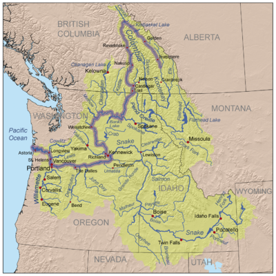
Canoe River is a tributary
of the Columbia River
in British Columbia
, Canada
. Its lower reach is flooded by Mica Dam
. The lower Canoe River is called Canoe Reach, part of the Mica Dam's reservoir, Kinbasket Lake
.
, west of Valemount, British Columbia
, and flows east to the vicinity of Valemount, then southeast to join the Columbia River at the "Big Bend" of the Columbia, just upriver from Mica Dam. The reservoir created by Mica Dam, Kinbasket Lake, extends up the Canoe River nearly to Valemount. This impounded portion of the river is called the Canoe Reach of Kinbasket Lake. Although originally the mouth of the Canoe River was at the Big Bend of the Columbia, today it is said to be at the northern end of Canoe Reach.
The main tributaries of Canoe River and Canoe Reach include Camp Creek, Packsaddle Creek, Dave Henry Creek, Yellowjacket Creek, Bulldog Creek, Ptarmigan Creek, Hugh Allan Creek, Grouse Creek, Windfall Creek, Howard Creek, Foster Creek (flows into Foster Arm), Dawson Creek, and, right at Big Bend, Wood River (flows into Wood Arm).
Most of Canoe River, in the form of Canoe Reach, occupies the Rocky Mountain Trench
, the same valley as the upper Fraser River
and its tributary the McLennan River, which reaches to Valemount. The Canoe River and Camp Creek, one of its main tributaries, drain a region just north and east of the headwaters of the North Thompson River
.
, who spent the winter at Boat Encampment
near the river's mouth in 1811.
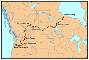
From the early 1820s until 1846 the Canoe River was a well-travelled section of the York Factory Express
HBC overland trade route between London
via Hudson Bay
and Fort Vancouver
on the lower Columbia River
.
Tributary
A tributary or affluent is a stream or river that flows into a main stem river or a lake. A tributary does not flow directly into a sea or ocean...
of the Columbia River
Columbia River
The Columbia River is the largest river in the Pacific Northwest region of North America. The river rises in the Rocky Mountains of British Columbia, Canada, flows northwest and then south into the U.S. state of Washington, then turns west to form most of the border between Washington and the state...
in British Columbia
British Columbia
British Columbia is the westernmost of Canada's provinces and is known for its natural beauty, as reflected in its Latin motto, Splendor sine occasu . Its name was chosen by Queen Victoria in 1858...
, Canada
Canada
Canada is a North American country consisting of ten provinces and three territories. Located in the northern part of the continent, it extends from the Atlantic Ocean in the east to the Pacific Ocean in the west, and northward into the Arctic Ocean...
. Its lower reach is flooded by Mica Dam
Mica Dam
The Mica Dam is a hydroelectric dam spanning the Columbia River 135 kilometres north of Revelstoke, British Columbia, Canada. Completed in 1973 under the terms of the 1964 Columbia River Treaty, the Mica powerhouse has a generating capacity of . The dam is operated by BC Hydro...
. The lower Canoe River is called Canoe Reach, part of the Mica Dam's reservoir, Kinbasket Lake
Kinbasket Lake
Kinbasket Lake is a reservoir on the Columbia River in southeast British Columbia, north of the city of Revelstoke and the town of Golden. The reservoir was created by the construction of the Mica Dam. The lake includes two reaches, Columbia Reach and Canoe Reach , referring to the river valleys...
.

Course
The Canoe River begins in the Cariboo MountainsCariboo Mountains
The Cariboo Mountains are the northernmost subrange of the Columbia Mountains, which run down into the Spokane, Washington area of the United States and include the Selkirks, Monashees and Purcells. The Cariboo Mountains are entirely within the province of British Columbia, Canada. The range is...
, west of Valemount, British Columbia
Valemount, British Columbia
Valemount is a village of 1,018 people in east central British Columbia, Canada. It is situated between the Rocky, Monashee, and Cariboo Mountains. It is the nearest community to the west of Jasper National Park, and is also the nearest community to Mount Robson Provincial Park, which features...
, and flows east to the vicinity of Valemount, then southeast to join the Columbia River at the "Big Bend" of the Columbia, just upriver from Mica Dam. The reservoir created by Mica Dam, Kinbasket Lake, extends up the Canoe River nearly to Valemount. This impounded portion of the river is called the Canoe Reach of Kinbasket Lake. Although originally the mouth of the Canoe River was at the Big Bend of the Columbia, today it is said to be at the northern end of Canoe Reach.
The main tributaries of Canoe River and Canoe Reach include Camp Creek, Packsaddle Creek, Dave Henry Creek, Yellowjacket Creek, Bulldog Creek, Ptarmigan Creek, Hugh Allan Creek, Grouse Creek, Windfall Creek, Howard Creek, Foster Creek (flows into Foster Arm), Dawson Creek, and, right at Big Bend, Wood River (flows into Wood Arm).
Most of Canoe River, in the form of Canoe Reach, occupies the Rocky Mountain Trench
Rocky Mountain Trench
The Rocky Mountain Trench, or the Trench or The Valley of a Thousand Peaks, is a large valley in the northern part of the Rocky Mountains. It is both visually and cartographically a striking physiographic feature extending approximately from Flathead Lake, Montana, to the Liard River, just south...
, the same valley as the upper Fraser River
Fraser River
The Fraser River is the longest river within British Columbia, Canada, rising at Fraser Pass near Mount Robson in the Rocky Mountains and flowing for , into the Strait of Georgia at the city of Vancouver. It is the tenth longest river in Canada...
and its tributary the McLennan River, which reaches to Valemount. The Canoe River and Camp Creek, one of its main tributaries, drain a region just north and east of the headwaters of the North Thompson River
Thompson River
The Thompson River is the largest tributary of the Fraser River, flowing through the south-central portion of British Columbia, Canada. The Thompson River has two main branches called the South Thompson and the North Thompson...
.
History
The Canoe River was named by David ThompsonDavid Thompson (explorer)
David Thompson was an English-Canadian fur trader, surveyor, and map-maker, known to some native peoples as "Koo-Koo-Sint" or "the Stargazer"...
, who spent the winter at Boat Encampment
Boat Encampment
Boat Encampment was a rendezvous and staging-point for the Hudson's Bay Company in the early 19th century and later a locality by that name in the Canadian province of British Columbia. It was located at the "top" of the Big Bend of the Columbia north of the city of Revelstoke, British Columbia...
near the river's mouth in 1811.
From the early 1820s until 1846 the Canoe River was a well-travelled section of the York Factory Express
York Factory Express
The York Factory Express, usually called "the Express" and also called the Columbia Express and the Communication, was a brigade operated by Hudson's Bay Company in the early 19th century connecting York Factory and Fort Vancouver. It was named "express" because it was not used only to transport...
HBC overland trade route between London
London
London is the capital city of :England and the :United Kingdom, the largest metropolitan area in the United Kingdom, and the largest urban zone in the European Union by most measures. Located on the River Thames, London has been a major settlement for two millennia, its history going back to its...
via Hudson Bay
Hudson Bay
Hudson Bay , sometimes called Hudson's Bay, is a large body of saltwater in northeastern Canada. It drains a very large area, about , that includes parts of Ontario, Quebec, Saskatchewan, Alberta, most of Manitoba, southeastern Nunavut, as well as parts of North Dakota, South Dakota, Minnesota,...
and Fort Vancouver
Fort Vancouver
Fort Vancouver was a 19th century fur trading outpost along the Columbia River that served as the headquarters of the Hudson's Bay Company in the company's Columbia District...
on the lower Columbia River
Columbia River
The Columbia River is the largest river in the Pacific Northwest region of North America. The river rises in the Rocky Mountains of British Columbia, Canada, flows northwest and then south into the U.S. state of Washington, then turns west to form most of the border between Washington and the state...
.


