
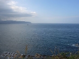
east of China. It is a part of the Pacific Ocean
and covers an area of 1,249,000 km² or 750,000 square miles.
The East China Sea is bounded on the east by the Kyūshū
and Ryukyu Islands
of Japan
, on the south by the island of Taiwan
, and on the west by mainland China
and the Asia
n continent. It is connected with the South China Sea
by the Taiwan Strait
and with the Sea of Japan
by the Korea Strait
; it opens in the north to the Yellow Sea
.
States with borders on the sea (clockwise from north) include: South Korea, Japan, Republic of China (Taiwan)
and the People's Republic of China.
Max depth: 3,000 m.
The International Hydrographic Organization
defines the limits of the "Eastern China Sea (Tung Hai)" as follows:
On the south. The northern limit of the South China SeaSouth China SeaThe South China Sea is a marginal sea that is part of the Pacific Ocean, encompassing an area from the Singapore and Malacca Straits to the Strait of Taiwan of around...
[From Fuki Kaku the north point of FormosaTaiwanTaiwan , also known, especially in the past, as Formosa , is the largest island of the same-named island group of East Asia in the western Pacific Ocean and located off the southeastern coast of mainland China. The island forms over 99% of the current territory of the Republic of China following...
to Kiushan Tao (Turnabout Island)Kiushan TaoKiushan Tao is an island east of China. It is also known as Niushan Dao , Niu Shan, and Turnabout Island. The island forms a part of the boundary between the East China Sea and the South China Sea.-External links:...
on to the south point of Haitan TaoPingtan IslandPingtan Island is located in eastern coastal area in Fujian province, China. It is the largest island in Fujian, and the fifth largest island in China...
(25°25'N) and thence westward on the parallel of 25°24' north to the coast of FukienFujian' , formerly romanised as Fukien or Huguing or Foukien, is a province on the southeast coast of mainland China. Fujian is bordered by Zhejiang to the north, Jiangxi to the west, and Guangdong to the south. Taiwan lies to the east, across the Taiwan Strait...] , thence from Santyo the northeastern point of Formosa to the west point of Yonakuni IslandYonaguniis one of the Yaeyama Islands. It is the westernmost inhabited island of Japan and lies from the east coast of Taiwan, between the East China Sea and the Pacific Ocean proper....
and thence to Haderuma SimaHaterumaHateruma is an island in the Yaeyama District of Okinawa Prefecture, Japan. Part of the town Taketomi, it is the southern-most inhabited island in Japan at 24°2’25” north latitude, 123°47’16” east longitude...
(24°03′N 123°47′E).
On the east. From Haderuma Sima a line including the Miyako Retto
Miyako IslandsThe are a group of islands in Okinawa Prefecture, Japan, east of the Yaeyama Islands.-Islands grouping:*Japanese Archipelago**Nansei Islands***Ryūkyū Shotō****Sakishima Islands*****Miyako Islands-Inhabited islands:*Miyako Islands...
to the east point of Miyako SimaMiyako-jimaMiyakojima is the largest and the most populous island among the Miyako Islands of Okinawa Prefecture, Japan. It lies approximately 400 kilometres east of Taipei, Taiwan...
and thence to Okinan Kaku, the southern extremity of Okinawa SimaOkinawa IslandOkinawa Island is the largest of the Okinawa Islands and the Ryukyu Islands of Japan, and is home to Naha, the capital of Okinawa Prefecture. The island has an area of...
through this island to Ada-Ko Sima (Sidmouth Island) on to the East point of Kikai SimaKikai, Kagoshimais a town located in Ōshima District, Kagoshima, Japan.As of 2008, the town had an estimated population of 8,207 and the density of 144 persons per km². The total area is 56.94 km².Kikai Airport is located in the town....
(28°20'N) through Tanegra SimaTanegashimais an island lying to the south of Kyushu, in southern Japan, and is part of Kagoshima Prefecture. The island is the second largest of the Ōsumi Islands....
(30°30'N) to the north point thereof and on to Hi-Saki (31'17'N) in KyūshūKyushuis the third largest island of Japan and most southwesterly of its four main islands. Its alternate ancient names include , , and . The historical regional name is referred to Kyushu and its surrounding islands....
.
On the north. From Nomo Saki (32°35'N) in Kyusyu to the south point of Hukae Sima (Goto Retto
Goto IslandsThe are Japanese islands in the East China Sea, off the western coast of Kyūshū. The islands are a part of Nagasaki Prefecture.- Geography :There are 140 islands in total, including five main islands:,,,, and....
) and on through this island to Ose Saki (Cape Goto) and to Hunan Kan, the South point of Saisyu ToJeju-doJeju-do is the only special autonomous province of South Korea, situated on and coterminous with the country's largest island. Jeju-do lies in the Korea Strait, southwest of Jeollanam-do Province, of which it was a part before it became a separate province in 1946...
(Quelpart), through this island to its western extreme and thence along the parallel of 33°17' north to the mainland.
On the west. The mainland of China.
The Yangtze River
(Chang Jiang) is the largest river flowing into the East China Sea.
- Senkaku IslandsSenkaku IslandsThe , also known as the Diaoyu Islands or Diaoyutai Islands or the Pinnacle Islands, are a group of disputed uninhabited islands in the East China Sea...
(Japanese) or Diaoyu Islands (Chinese).