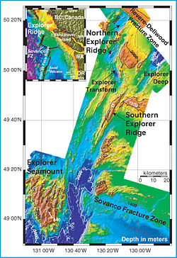
Explorer Ridge
Encyclopedia


Mid-ocean ridge
A mid-ocean ridge is a general term for an underwater mountain system that consists of various mountain ranges , typically having a valley known as a rift running along its spine, formed by plate tectonics. This type of oceanic ridge is characteristic of what is known as an oceanic spreading...
, a divergent tectonic plate
Plate tectonics
Plate tectonics is a scientific theory that describes the large scale motions of Earth's lithosphere...
boundary located about 241 km (150 mi) west of Vancouver Island
Vancouver Island
Vancouver Island is a large island in British Columbia, Canada. It is one of several North American locations named after George Vancouver, the British Royal Navy officer who explored the Pacific Northwest coast of North America between 1791 and 1794...
, British Columbia
British Columbia
British Columbia is the westernmost of Canada's provinces and is known for its natural beauty, as reflected in its Latin motto, Splendor sine occasu . Its name was chosen by Queen Victoria in 1858...
, Canada
Canada
Canada is a North American country consisting of ten provinces and three territories. Located in the northern part of the continent, it extends from the Atlantic Ocean in the east to the Pacific Ocean in the west, and northward into the Arctic Ocean...
. It lies at the northern extremity of the Pacific spreading axis. To its east is the Explorer Plate
Explorer Plate
The Explorer Plate is an oceanic tectonic plate beneath the Pacific Ocean off the west coast of Vancouver Island, Canada.The eastern boundary of the Explorer Plate is being slowly subducted under the North American Plate, to which it may eventually accrete owing to the slow rate of subduction...
, which together with the Juan de Fuca Plate
Juan de Fuca Plate
The Juan de Fuca Plate, named after the explorer of the same name, is a tectonic plate, generated from the Juan de Fuca Ridge, and subducting under the northerly portion of the western side of the North American Plate at the Cascadia subduction zone...
and the Gorda Plate
Gorda Plate
The Gorda Plate, located beneath the Pacific Ocean off the coast of northern California, is one of the northern remnants of the Farallon Plate. It is sometimes referred to as simply the southernmost portion of the neighboring Juan de Fuca Plate, another Farallon remnant.Unlike most tectonic...
to its south, is what remains of the once-vast Farallon Plate
Farallon Plate
The Farallon Plate was an ancient oceanic plate, which began subducting under the west coast of the North American Plate— then located in modern Utah— as Pangaea broke apart during the Jurassic Period...
which has been largely subducted
Subduction
In geology, subduction is the process that takes place at convergent boundaries by which one tectonic plate moves under another tectonic plate, sinking into the Earth's mantle, as the plates converge. These 3D regions of mantle downwellings are known as "Subduction Zones"...
under the North American Plate
North American Plate
The North American Plate is a tectonic plate covering most of North America, Greenland, Cuba, Bahamas, and parts of Siberia, Japan and Iceland. It extends eastward to the Mid-Atlantic Ridge and westward to the Chersky Range in eastern Siberia. The plate includes both continental and oceanic crust...
. The Explorer Ridge consists of one major segment, the Southern Explorer Ridge, and several smaller segments. It runs northward from the Queen Charlotte Triple Junction
Queen Charlotte Triple Junction
The Queen Charlotte Triple Junction is a geologic triple junction where three tectonic plates meet: the Pacific Plate, the North American Plate, and the Explorer Plate. The three plate boundaries which intersect here are: the Queen Charlotte Fault, the Cascadia subduction zone, and the Explorer...
, a point where the Nootka Fault
Nootka Fault
The Nootka Fault is an active transform fault running southwest from Nootka Island, near Vancouver Island, British Columbia, Canada.-Geology:...
, the Sovanco Fracture Zone
Sovanco Fracture Zone
The Sovanco Fracture Zone is a right lateral-moving transform fault and associated fracture zone located offshore of Vancouver Island in Canada. It runs between the northern end of the Juan de Fuca Ridge and the southern end of the Explorer Ridge, forming part of the boundary between the Pacific...
and the Juan de Fuca Ridge
Juan de Fuca Ridge
The Juan de Fuca Ridge is a tectonic spreading center located off the coasts of the state of Washington in the United States and the province of British Columbia in Canada. It runs northward from a transform boundary, the Blanco Fracture Zone, to a triple junction with the Nootka Fault and the...
meet.
Geology
This divergent boundary first formed about 5-7 million years ago when the northern end of the Juan de Fuca PlateJuan de Fuca Plate
The Juan de Fuca Plate, named after the explorer of the same name, is a tectonic plate, generated from the Juan de Fuca Ridge, and subducting under the northerly portion of the western side of the North American Plate at the Cascadia subduction zone...
broke off along the Nootka Fault
Nootka Fault
The Nootka Fault is an active transform fault running southwest from Nootka Island, near Vancouver Island, British Columbia, Canada.-Geology:...
to form the Explorer Plate
Explorer Plate
The Explorer Plate is an oceanic tectonic plate beneath the Pacific Ocean off the west coast of Vancouver Island, Canada.The eastern boundary of the Explorer Plate is being slowly subducted under the North American Plate, to which it may eventually accrete owing to the slow rate of subduction...
. This apparently had some important ramifications for regional geologic evolution. When this change was completed, Cascade Arc
Cascade Volcanoes
The Cascade Volcanoes are a number of volcanoes in a volcanic arc in western North America, extending from southwestern British Columbia through Washington and Oregon to Northern California, a distance of well over 700 mi ...
volcanism from Northern California
Northern California
Northern California is the northern portion of the U.S. state of California. The San Francisco Bay Area , and Sacramento as well as its metropolitan area are the main population centers...
to southwestern British Columbia returned and the present-day Cascade Range
Cascade Range
The Cascade Range is a major mountain range of western North America, extending from southern British Columbia through Washington and Oregon to Northern California. It includes both non-volcanic mountains, such as the North Cascades, and the notable volcanoes known as the High Cascades...
and Olympic Mountains
Olympic Mountains
The Olympic Mountains is a mountain range on the Olympic Peninsula of western Washington in the United States. The mountains, part of the Pacific Coast Ranges, are not especially high - Mount Olympus is the highest at - but the western slopes of the Olympics rise directly out of the Pacific...
started to form.
The oceanic crust
Oceanic crust
Oceanic crust is the part of Earth's lithosphere that surfaces in the ocean basins. Oceanic crust is primarily composed of mafic rocks, or sima, which is rich in iron and magnesium...
is moving away from the Explorer Ridge to either side. On the eastern side the eastward moving Explorer Plate is being subducted under the North American Plate
North American Plate
The North American Plate is a tectonic plate covering most of North America, Greenland, Cuba, Bahamas, and parts of Siberia, Japan and Iceland. It extends eastward to the Mid-Atlantic Ridge and westward to the Chersky Range in eastern Siberia. The plate includes both continental and oceanic crust...
. The belt of volcano
Volcano
2. Bedrock3. Conduit 4. Base5. Sill6. Dike7. Layers of ash emitted by the volcano8. Flank| 9. Layers of lava emitted by the volcano10. Throat11. Parasitic cone12. Lava flow13. Vent14. Crater15...
es along the Pacific Ranges
Pacific Ranges
The Pacific Ranges are the southernmost subdivision of the Coast Mountains portion of the Pacific Cordillera. Located entirely within British Columbia, Canada, they run northwest from the lower stretches of the Fraser River to Bella Coola, north of which are the Kitimat Ranges.The Pacific Ranges...
are the direct results of this collision. The western side of the Explorer Ridge is associated with the northwest trending Pacific Plate
Pacific Plate
The Pacific Plate is an oceanic tectonic plate that lies beneath the Pacific Ocean. At 103 million square kilometres, it is the largest tectonic plate....
which has formed the Queen Charlotte Fault
Queen Charlotte Fault
The Queen Charlotte Fault is an active transform fault, located between the North American Plate and the Pacific Plate, Canada's equivalent of the San Andreas Fault. The Queen Charlotte Fault forms a triple junction on its south with the Cascadia subduction zone and the Explorer Ridge...
, an active transform fault
Transform fault
A transform fault or transform boundary, also known as conservative plate boundary since these faults neither create nor destroy lithosphere, is a type of fault whose relative motion is predominantly horizontal in either sinistral or dextral direction. Furthermore, transform faults end abruptly...
along the coast of British Columbia and southeast Alaska
Alaska
Alaska is the largest state in the United States by area. It is situated in the northwest extremity of the North American continent, with Canada to the east, the Arctic Ocean to the north, and the Pacific Ocean to the west and south, with Russia further west across the Bering Strait...
.
The Explorer Ridge is also seismically
Seismology
Seismology is the scientific study of earthquakes and the propagation of elastic waves through the Earth or through other planet-like bodies. The field also includes studies of earthquake effects, such as tsunamis as well as diverse seismic sources such as volcanic, tectonic, oceanic,...
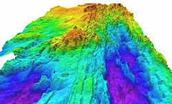
active. Most seismicity recorded in this area occurred on or near the Explorer Transform Fault Zone. The relatively shallow depth of the Southern Explorer Ridge (up to 1800 m) in comparison with most other segments of the northeast Pacific spreading centers suggests that there has been considerable volcanic activity along this segment in the past 100,000 years.
Notable features along the ridge
The Explorer Ridge includes a deep rift valleyRift valley
A rift valley is a linear-shaped lowland between highlands or mountain ranges created by the action of a geologic rift or fault. This action is manifest as crustal extension, a spreading apart of the surface which is subsequently further deepened by the forces of erosion...
which runs along the axis of the ridge along nearly its entire length. This rift marks the actual boundary adjacent tectonic plates, where magma
Magma
Magma is a mixture of molten rock, volatiles and solids that is found beneath the surface of the Earth, and is expected to exist on other terrestrial planets. Besides molten rock, magma may also contain suspended crystals and dissolved gas and sometimes also gas bubbles. Magma often collects in...
from the mantle
Mantle (geology)
The mantle is a part of a terrestrial planet or other rocky body large enough to have differentiation by density. The interior of the Earth, similar to the other terrestrial planets, is chemically divided into layers. The mantle is a highly viscous layer between the crust and the outer core....
reaches the seafloor, erupting as lava
Lava
Lava refers both to molten rock expelled by a volcano during an eruption and the resulting rock after solidification and cooling. This molten rock is formed in the interior of some planets, including Earth, and some of their satellites. When first erupted from a volcanic vent, lava is a liquid at...
and producing new crustal material for the plates.
Before 2002 Explorer Ridge was the least explored of the northeast Pacific spreading centers, even though it was known to have robust hydrothermal activity and is seismically
Seismology
Seismology is the scientific study of earthquakes and the propagation of elastic waves through the Earth or through other planet-like bodies. The field also includes studies of earthquake effects, such as tsunamis as well as diverse seismic sources such as volcanic, tectonic, oceanic,...
active. Along the Southern Explorer Ridge lies a large hydrothermal vent
Hydrothermal vent
A hydrothermal vent is a fissure in a planet's surface from which geothermally heated water issues. Hydrothermal vents are commonly found near volcanically active places, areas where tectonic plates are moving apart, ocean basins, and hotspots. Hydrothermal vents exist because the earth is both...
area called Magic Mountain. It is an unusual hydrothermal site, with its off-axis location and relatively long-lived activity. The source of the hydrothermal fluid that fuels Magic Mountain probably rises along fault systems associated with a recent episode of rifting that, in turn, followed a massive outpouring of lava. These vents are forming seafloor massive sulfide deposits
Seafloor massive sulfide deposits
Seafloor massive sulfide deposits or SMS deposits, are modern equivalents of ancient volcanogenic massive sulfide ore deposits or VMS deposits. The term has been coined by mineral explorers to differentiate the modern deposit from the ancient....
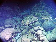
on the ocean floor. Many strange deep-water creatures have been found here.
See also
- Volcanism in CanadaVolcanism in CanadaVolcanism of Canada has produced lava flows, lava plateaus, lava domes, cinder cones, stratovolcanoes, shield volcanoes, submarine volcanoes, calderas, diatremes, and maars, along with examples of more less common volcanic forms such as tuyas and subglacial mounds...
- Geology of the Pacific NorthwestGeology of the Pacific NorthwestThe geology of the Pacific Northwest refers to the study of the composition , structure, physical properties and the processes that shape the Pacific Northwest region of the United States and Canada...
- Sovanco Fracture ZoneSovanco Fracture ZoneThe Sovanco Fracture Zone is a right lateral-moving transform fault and associated fracture zone located offshore of Vancouver Island in Canada. It runs between the northern end of the Juan de Fuca Ridge and the southern end of the Explorer Ridge, forming part of the boundary between the Pacific...
- Juan de Fuca RidgeJuan de Fuca RidgeThe Juan de Fuca Ridge is a tectonic spreading center located off the coasts of the state of Washington in the United States and the province of British Columbia in Canada. It runs northward from a transform boundary, the Blanco Fracture Zone, to a triple junction with the Nootka Fault and the...
- Gorda RidgeGorda RidgeThe Gorda Ridge is a tectonic spreading center located off the coast of Oregon and northern California north of Cape Mendocino. It runs from a triple junction with the San Andreas Fault and the Mendocino Fracture Zone northward to another transform boundary, the Blanco Fracture Zone...

