Garibaldi Provincial Park
Encyclopedia
Garibaldi Provincial Park, also called Garibaldi Park, is a wilderness park located in British Columbia
, Canada
, about 70 kilometres (43.5 mi) north of Vancouver
. The park is located to the east of the Sea to Sky Highway between Squamish
and Whistler
and covers an area of over 1,950 square kilometres (753 sq mi). Garibaldi was designated as a provincial park in 1927, and originally included what was later split off in 1967 as Golden Ears Provincial Park
, which juts southward between the basins of Pitt Lake
and the Stave River
into the Municipality of Maple Ridge
.
and other volcanoes related to subduction
volcanism in the Garibaldi Volcanic Belt
. The Park features many dense Douglas-fir
, western red cedar and western hemlock
forests, as well as alpine meadows, and many rocky alpine areas. The highest peak in the Park is Wedge Mountain
at 2891 metres (9482 ft).
opportunities. All access points are open in winter for backcountry skiing
, but only the Diamond Head access road is plowed. All camp sites are first-come, first-served.
Diamond Head
This southern most entrance provides hiking or skiing access to the area south of Mount Garibaldi
. A cooking hut and winter-only camping area are located in Red Heather Meadows, about 5 kilometres (3 mi) from the parking lot. An overnight shelter and campground are located 12 kilometres (7.5 mi) from the parking lot at Elfin Lakes
.
Black Tusk/Garibaldi Lake
The second entrance is located approximately half way between Squamish and Whistler. Hiking trails provide access to Garibaldi Lake
, the Black Tusk
, and Panorama Ridge. A trail also connects to the Cheakamus Lake
area further north. Two camping areas provide sites for 90 tents.
 Cheakamus Lake
This entrance, located just to the south of Whistler, provides access to Cheakamus Lake. Two campgrounds are located a few kilometers from the parking lot.
Singing Pass
The Singing Pass area is located to the east of Whistler Mountain
. The area can be accessed by a trail which follows the Fitzsimmons Creek, between Whistler and Blackcomb
mountains. The area can also be accessed from the top of Whistler mountain via an alpine route. Camping is permitted at Russet Lake.
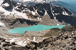
Wedgemount Lake
The most northern entrance is via a deactivated forest service road. The road is unmaintained and is recommended for 4x4 vehicles only. Wedgemount Lake is accessed via a hiking trail. Camping is permitted around the lake.
British Columbia
British Columbia is the westernmost of Canada's provinces and is known for its natural beauty, as reflected in its Latin motto, Splendor sine occasu . Its name was chosen by Queen Victoria in 1858...
, Canada
Canada
Canada is a North American country consisting of ten provinces and three territories. Located in the northern part of the continent, it extends from the Atlantic Ocean in the east to the Pacific Ocean in the west, and northward into the Arctic Ocean...
, about 70 kilometres (43.5 mi) north of Vancouver
Vancouver
Vancouver is a coastal seaport city on the mainland of British Columbia, Canada. It is the hub of Greater Vancouver, which, with over 2.3 million residents, is the third most populous metropolitan area in the country,...
. The park is located to the east of the Sea to Sky Highway between Squamish
Squamish, British Columbia
Squamish is a community and a district municipality in the Canadian province of British Columbia, located at the north end of Howe Sound on the Sea to Sky Highway...
and Whistler
Whistler, British Columbia
Whistler is a Canadian resort town in the southern Pacific Ranges of the Coast Mountains in the province of British Columbia, Canada, approximately north of Vancouver...
and covers an area of over 1,950 square kilometres (753 sq mi). Garibaldi was designated as a provincial park in 1927, and originally included what was later split off in 1967 as Golden Ears Provincial Park
Golden Ears Provincial Park
Golden Ears Provincial Park is a Provincial Park in British Columbia, Canada at 555.9 km². It is named after the prominent twin peaks which are commonly referred to as Golden Ears...
, which juts southward between the basins of Pitt Lake
Pitt Lake
Pitt Lake is the second-largest lake in the Lower Mainland of British Columbia, being about 53.5 square kilometres in area. It is about 25 km long and about 4.5 km wide at its widest, and is also one of the world's largest tidal lakes, its confluence with the Fraser being only a few miles upstream...
and the Stave River
Stave River
The Stave River is a tributary of the Fraser, joining it at the boundary between the municipalities of Maple Ridge and Mission, about 35 km east of Vancouver, British Columbia, Canada, in the Central Fraser Valley region....
into the Municipality of Maple Ridge
Maple Ridge, British Columbia
Maple Ridge is a District Municipality in British Columbia, located in the northeastern section of Metro Vancouver. Maple Ridge has a population of approximately 68,949.-History:...
.
Region
The park consists of many steep, rugged mountains, many of which are capped by glaciers. The park includes Mount GaribaldiMount Garibaldi
Mount Garibaldi is a potentially active stratovolcano in the Sea to Sky Country of British Columbia, north of Vancouver, Canada. Located in the southernmost Coast Mountains, it is one of the most recognized peaks in the South Coast region, as well as British Columbia's best known volcano...
and other volcanoes related to subduction
Subduction
In geology, subduction is the process that takes place at convergent boundaries by which one tectonic plate moves under another tectonic plate, sinking into the Earth's mantle, as the plates converge. These 3D regions of mantle downwellings are known as "Subduction Zones"...
volcanism in the Garibaldi Volcanic Belt
Garibaldi Volcanic Belt
The Garibaldi Volcanic Belt, also called the Canadian Cascade Arc, is a northwest-southeast trending volcanic chain in the Pacific Ranges of the Coast Mountains that extends from Watts Point in the south to the Ha-Iltzuk Icefield in the north. This chain of volcanoes is located in southwestern...
. The Park features many dense Douglas-fir
Douglas-fir
Douglas-fir is one of the English common names for evergreen coniferous trees of the genus Pseudotsuga in the family Pinaceae. Other common names include Douglas tree, and Oregon pine. There are five species, two in western North America, one in Mexico, and two in eastern Asia...
, western red cedar and western hemlock
Western Hemlock
Tsuga heterophylla. the Western Hemlock, is a species of hemlock native to the west coast of North America, with its northwestern limit on the Kenai Peninsula, Alaska, and its southeastern limit in northern Sonoma County, California.-Habitat:...
forests, as well as alpine meadows, and many rocky alpine areas. The highest peak in the Park is Wedge Mountain
Wedge Mountain
Wedge Mountain, 2892 m prominence: 2249 m, often locally referred to as The Wedge or simply "Wedge", is the highest summit in the Garibaldi Ranges and therefore also Garibaldi Provincial Park, and is among the nearest of the many peaks visible from the Whistler Blackcomb Ski Area, lying north...
at 2891 metres (9482 ft).
Recreational access
There are five park access and entrance points located along the Sea to Sky Highway. Each entrance provides access to hiking trails with backcountry campingBackpacking (wilderness)
Backpacking combines the activities of hiking and camping for an overnight stay in backcountry wilderness...
opportunities. All access points are open in winter for backcountry skiing
Backcountry skiing
Backcountry skiing is skiing in a sparsely inhabited rural region over ungroomed and unmarked slopes or pistes, including skiing in unmarked or unpatrolled areas either within the ski resort's boundaries or in the backcountry, frequently amongst trees , usually in pursuit of fresh fallen powder...
, but only the Diamond Head access road is plowed. All camp sites are first-come, first-served.
Diamond Head
This southern most entrance provides hiking or skiing access to the area south of Mount Garibaldi
Mount Garibaldi
Mount Garibaldi is a potentially active stratovolcano in the Sea to Sky Country of British Columbia, north of Vancouver, Canada. Located in the southernmost Coast Mountains, it is one of the most recognized peaks in the South Coast region, as well as British Columbia's best known volcano...
. A cooking hut and winter-only camping area are located in Red Heather Meadows, about 5 kilometres (3 mi) from the parking lot. An overnight shelter and campground are located 12 kilometres (7.5 mi) from the parking lot at Elfin Lakes
Elfin Lakes
Elfin Lakes are two lakes in Garibaldi Provincial Park that are popular for hiking, snowshoeing, skiing, and mountain bicycling trail located east of Squamish, British Columbia, Canada.-History:...
.
Black Tusk/Garibaldi Lake
The second entrance is located approximately half way between Squamish and Whistler. Hiking trails provide access to Garibaldi Lake
Garibaldi Lake
The Garibaldi Lake volcanic field is a volcanic field, located in British Columbia, Canada. It was formed by a group of nine small andesitic stratovolcanoes and basaltic andesite vents in the scenic Garibaldi Lake area immediately north of Mount Garibaldi was formed during the late Pleistocene and...
, the Black Tusk
Black Tusk
Black Tusk is a remarkably abrupt pinnacle of volcanic rock located in Garibaldi Provincial Park of British Columbia, Canada. At above sea level, the upper spire is visible from a great distance in all directions. It is particularly noticeable from the Sea-to-Sky Highway just south of Whistler,...
, and Panorama Ridge. A trail also connects to the Cheakamus Lake
Cheakamus Lake
Cheakamus Lake is a lake in Garibaldi Provincial Park on the southeastern outskirts of the resort municipality of Whistler, British Columbia. It has an area of 5.7 km²...
area further north. Two camping areas provide sites for 90 tents.

This entrance, located just to the south of Whistler, provides access to Cheakamus Lake. Two campgrounds are located a few kilometers from the parking lot.
Singing Pass
The Singing Pass area is located to the east of Whistler Mountain
Whistler Mountain
Whistler Mountain is a mountain in the Fitzsimmons Range of the Pacific Ranges of the Coast Mountains, located on the northwestern edge of Garibaldi Provincial Park. It is the location of the Whistler-Blackcomb ski resort and the town of Whistler, British Columbia.The original name of the mountain...
. The area can be accessed by a trail which follows the Fitzsimmons Creek, between Whistler and Blackcomb
Blackcomb Peak
Blackcomb Peak is a mountain located east of Whistler, British Columbia and forms the boundary between the Whistler Blackcomb ski resort and Garibaldi Provincial Park...
mountains. The area can also be accessed from the top of Whistler mountain via an alpine route. Camping is permitted at Russet Lake.
Wedgemount Lake
The most northern entrance is via a deactivated forest service road. The road is unmaintained and is recommended for 4x4 vehicles only. Wedgemount Lake is accessed via a hiking trail. Camping is permitted around the lake.

