
Glastonbury Canal
Encyclopedia
The Glastonbury Canal ran for just over 14 miles (22.5 km) through two locks from Glastonbury
to Highbridge
in Somerset
, England
, where it entered the River Parrett
and from there the Bristol Channel
. The canal was authorised by Parliament
in 1827 and opened in 1834. It was operated by The Glastonbury Navigation & Canal Company. Most of it was abandoned as a navigation in 1854, when a railway was built along the towpath.
is situated in an area of low-lying land, through which rivers and drainage ditches (locally called "rhynes
") run. There is evidence that the town was served by a canal connecting it to the river system in the Saxon
period, and the waterways were later used by the monks who were located at Glastonbury Abbey
, both for draining the land and for transport of produce. In the 1750s, the town became a spa town, when the waters of the Challice Well spring were thought to have medicinal properties, but this did not last for long, while the predominant wool and cloth industries declined as the mills of the north of England took the trade.
The area was hit by severe floods in 1794, as a result of which the Commissioners of Sewers obtained the Brue Drainage Act in 1801, which allowed them to improve the course of the River Brue
by the straightening of major loops at Highbridge
and East Huntspill, and to construct the North and South Drains, which collected water from the peat
moorland
s and channelled it into the lower River Brue. Under the terms of the Act, two small canals, called Galton's Canal
and Brown's Canal, were built near the North Drain to serve peat extraction workings. The drainage works were not wholly successful in preventing flooding, and the Commissioners often failed to obtain the levies they required to finance their operations.
, was commissioned to conduct a survey of the route in 1826. Hammett had experience of building a manure canal through peat
heathland. He considered two main routes; the first followed the course of the River Brue, but was rejected on the grounds of engineering costs, and the interference with its drainage function. The second route followed the newly-constructed South Drain, to connect with the River Brue near Cripps Bridge, and to re-use the old course of that River at Highbridge to create a basin.
Hammett estimated that the main work required on the section from Highbridge to the South Drain would be the provision of a towpath. After this, the South Drain would need to be made wider and deeper, but this would aid its drainage function, and would reduce the levy on the local landowners, as the canal company would then be responsible for its maintenance. Two locks would be required on this upper section, with a total rise of just 7 feet (2.1 m). He did not believe that cutting a canal through peat would present serious engineering problems as a result of his previous experience with the manure canal, but he seriously under-estimated the cost at £9,000.
A prospectus was issued which contained a detailed breakdown of the likely costs, revenue and profits of such a scheme, and the promotors prepared to obtain an Act of Parliament
. During this time, someone challenged the original survey and another local surveyor was asked to review it. John Beauchamp suggested that no locks would be required on the upper section, but that costs were likely to be £15,234. This was later raised to £18,000, and the Act of Parliament, which authorised the construction of a canal that followed Hammett's plans, was obtained on 28 May 1827. The proprietors were empowered to raise £18,000 by the issue of 360 shares of £50 each, with powers to raise another £5,000 by mortgage, or to borrow any part of the £18,000 from the Exchequer Bills Commissioners.
that worked the Bristol Channel
to use the canal. This option required locks of 64 feet (19.5 m) by 18 feet (5.5 m), and was costed at £28,720. The route would be as authorised, but a single lock was required on the upper section to simplify the water supply. Work resumed in July 1828.
At the Glastonbury end, the canal was required to cross the South Drain and the River Brue. Rennie suggested inverted syphons, rather than locking down into the river and up again, and a cast iron aqueduct for the River Brue crossing was obtained for nearly £3,000 from a Glastonbury blacksmith called John Wright. At the Highbridge end, the plans for a floating harbour to accommodate vessels of up to 250 tons were dropped, and the entrance lock was moved further along the original course of the River Brue. This saved money, but meant that ships did not have to pay lockage changes to reach Highbridge.
The proprietors failed to raise all of the capital promised, and there were financial difficulties. The Commissioners of Sewers were unhappy with some of the work at Highbridge in 1830, and reported that the contractor "had run away", and work had stopped in 1831. The company had also failed to lodge £1,000 with the Commissioners which was required to cover any costs they might have as a result of the construction of the canal, and they sued for the money in 1831. Even Rennie threatened to sue, as much of his fee remained unpaid. The cost of construction was about £30,000, but it appears that some debts were never paid. On 16 December 1831 the proprietors borrowed £5,000 from the Exchequer at a 5 per cent rate of interest.
On the upper section, the final pound prevented the proper drainage of the surrounding land, which being peat started to swell. This caused the canal to rise and the clay puddling to fracture, resulting in further loss of water, and a reduced depth for navigation. Traffic had to be transhipped to smaller boats at Highbridge, which added to the costs of delivery. Receipts for 1848 were £300, which would indicate that the canal was probably only carrying about 4,000 tons per annum.
on 14 June, which eventually reached Exeter in 1844. In late 1846, the railway company attempted to buy the canal to prevent its use by rival railway companies. The sale was agreed in principle in June 1847, and was authorised by an act of Parliament passed on 30 June 1848. The shareholders received £7,372 in 1850, and the canal company was dissolved in 1851.
There was friction between the new owners and the Commissioners of Sewers. The railway company proposed the creation of a railway between Highbridge and Glastonbury in 1850, and the Somerset Central Railway was authorised by Parliament on 17 June 1852. The canal was transferred to the new company, and was used to speed the construction of the railway, earning £312 in the year ending September 1853. The line followed the route of the canal closely, with much of it built on the towpath. The canal was closed on 1 July 1854, and the lock and aqueducts on the upper section were dismantled. The railway opened on 17 August 1854.
The lower sections of the canal were given to the Commissioners for Sewers, for use as a drainage ditch. The final section was retained to provide a wharf for the railway company, which was used until 1936, when it passed to the Commissioners of Sewers and was filled in. The Central Somerset Railway merged with the Dorset Central Railway to become the Somerset and Dorset Railway. The main line to Glastonbury closed in 1966, while the branches to the dairy
at Bason Bridge
and the Highbridge Wharf lasted until 1972.
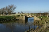
Following the course of the enlarged South Drain, a lock raised the level of the canal at Shapwick
, while the Drain turned off to run parallel to the canal but to its north. The railway ran between the two waterways, crossing to the south side of the canal immediately after the single arched aqueduct and syphon over the South Drain. The remains of the three-arched aqueduct and syphon over the River Brue
are still visible, near the old railway bridge, and from there the canal headed towards Glastonbury
, making a sharp right-hand turn just before its terminal basin, which was located near the old Glastonbury and Street railway station
.
Glastonbury
Glastonbury is a small town in Somerset, England, situated at a dry point on the low lying Somerset Levels, south of Bristol. The town, which is in the Mendip district, had a population of 8,784 in the 2001 census...
to Highbridge
Highbridge, Somerset
Highbridge is a small market town situated on the edge of the Somerset Levels near the mouth of the River Brue. It is in the County of Somerset, and is approximately north west of Taunton, the county town of Somerset. Highbridge is in the District of Sedgemoor, being situated approximately north...
in Somerset
Somerset
The ceremonial and non-metropolitan county of Somerset in South West England borders Bristol and Gloucestershire to the north, Wiltshire to the east, Dorset to the south-east, and Devon to the south-west. It is partly bounded to the north and west by the Bristol Channel and the estuary of the...
, England
England
England is a country that is part of the United Kingdom. It shares land borders with Scotland to the north and Wales to the west; the Irish Sea is to the north west, the Celtic Sea to the south west, with the North Sea to the east and the English Channel to the south separating it from continental...
, where it entered the River Parrett
River Parrett
The River Parrett flows through the counties of Dorset and Somerset in South West England, from its source in the Thorney Mills springs in the hills around Chedington in Dorset...
and from there the Bristol Channel
Bristol Channel
The Bristol Channel is a major inlet in the island of Great Britain, separating South Wales from Devon and Somerset in South West England. It extends from the lower estuary of the River Severn to the North Atlantic Ocean...
. The canal was authorised by Parliament
Parliament of the United Kingdom
The Parliament of the United Kingdom of Great Britain and Northern Ireland is the supreme legislative body in the United Kingdom, British Crown dependencies and British overseas territories, located in London...
in 1827 and opened in 1834. It was operated by The Glastonbury Navigation & Canal Company. Most of it was abandoned as a navigation in 1854, when a railway was built along the towpath.
Background
GlastonburyGlastonbury
Glastonbury is a small town in Somerset, England, situated at a dry point on the low lying Somerset Levels, south of Bristol. The town, which is in the Mendip district, had a population of 8,784 in the 2001 census...
is situated in an area of low-lying land, through which rivers and drainage ditches (locally called "rhynes
Rhyne
A rhyne , rhine/rhyne , or reen is a drainage ditch, or canal, used to turn areas of wetland at around sea level into useful pasture....
") run. There is evidence that the town was served by a canal connecting it to the river system in the Saxon
Saxons
The Saxons were a confederation of Germanic tribes originating on the North German plain. The Saxons earliest known area of settlement is Northern Albingia, an area approximately that of modern Holstein...
period, and the waterways were later used by the monks who were located at Glastonbury Abbey
Glastonbury Abbey
Glastonbury Abbey was a monastery in Glastonbury, Somerset, England. The ruins are now a grade I listed building, and a Scheduled Ancient Monument and are open as a visitor attraction....
, both for draining the land and for transport of produce. In the 1750s, the town became a spa town, when the waters of the Challice Well spring were thought to have medicinal properties, but this did not last for long, while the predominant wool and cloth industries declined as the mills of the north of England took the trade.
The area was hit by severe floods in 1794, as a result of which the Commissioners of Sewers obtained the Brue Drainage Act in 1801, which allowed them to improve the course of the River Brue
River Brue
The River Brue originates in the parish of Brewham in Somerset, England, and reaches the sea some 50 km west at Burnham-on-Sea. It originally took a different route from Glastonbury to the sea, but this was changed by the monastery in the twelfth century....
by the straightening of major loops at Highbridge
Highbridge, Somerset
Highbridge is a small market town situated on the edge of the Somerset Levels near the mouth of the River Brue. It is in the County of Somerset, and is approximately north west of Taunton, the county town of Somerset. Highbridge is in the District of Sedgemoor, being situated approximately north...
and East Huntspill, and to construct the North and South Drains, which collected water from the peat
Peat
Peat is an accumulation of partially decayed vegetation matter or histosol. Peat forms in wetland bogs, moors, muskegs, pocosins, mires, and peat swamp forests. Peat is harvested as an important source of fuel in certain parts of the world...
moorland
Moorland
Moorland or moor is a type of habitat, in the temperate grasslands, savannas, and shrublands biome, found in upland areas, characterised by low-growing vegetation on acidic soils and heavy fog...
s and channelled it into the lower River Brue. Under the terms of the Act, two small canals, called Galton's Canal
Galton's Canal
Galton's Canal was a 1 mile 3 furlong canal with one lock, crossing Westhay Moor in Somerset, England, and connecting the River Brue to the North Drain...
and Brown's Canal, were built near the North Drain to serve peat extraction workings. The drainage works were not wholly successful in preventing flooding, and the Commissioners often failed to obtain the levies they required to finance their operations.
Promotion and planning
One of the key promoters for a canal was Richard Prat, who was a lawyer in Glastonbury, had been the town clerk since 1813, and held several important offices in the town. He saw the canal as a way to halt the economic downturn in the town and its drainage problems, and called a meeting in August 1825, at which a firm plan was formulated. Richard Hammett, a local man from StreetStreet, Somerset
Street is a small village and civil parish in the county of Somerset, England. It is situated on a dry spot in the Somerset Levels, at the end of the Polden Hills, south-west of Glastonbury. The 2001 census records the village as having a population of 11,066...
, was commissioned to conduct a survey of the route in 1826. Hammett had experience of building a manure canal through peat
Peat
Peat is an accumulation of partially decayed vegetation matter or histosol. Peat forms in wetland bogs, moors, muskegs, pocosins, mires, and peat swamp forests. Peat is harvested as an important source of fuel in certain parts of the world...
heathland. He considered two main routes; the first followed the course of the River Brue, but was rejected on the grounds of engineering costs, and the interference with its drainage function. The second route followed the newly-constructed South Drain, to connect with the River Brue near Cripps Bridge, and to re-use the old course of that River at Highbridge to create a basin.
Hammett estimated that the main work required on the section from Highbridge to the South Drain would be the provision of a towpath. After this, the South Drain would need to be made wider and deeper, but this would aid its drainage function, and would reduce the levy on the local landowners, as the canal company would then be responsible for its maintenance. Two locks would be required on this upper section, with a total rise of just 7 feet (2.1 m). He did not believe that cutting a canal through peat would present serious engineering problems as a result of his previous experience with the manure canal, but he seriously under-estimated the cost at £9,000.
A prospectus was issued which contained a detailed breakdown of the likely costs, revenue and profits of such a scheme, and the promotors prepared to obtain an Act of Parliament
Act of Parliament
An Act of Parliament is a statute enacted as primary legislation by a national or sub-national parliament. In the Republic of Ireland the term Act of the Oireachtas is used, and in the United States the term Act of Congress is used.In Commonwealth countries, the term is used both in a narrow...
. During this time, someone challenged the original survey and another local surveyor was asked to review it. John Beauchamp suggested that no locks would be required on the upper section, but that costs were likely to be £15,234. This was later raised to £18,000, and the Act of Parliament, which authorised the construction of a canal that followed Hammett's plans, was obtained on 28 May 1827. The proprietors were empowered to raise £18,000 by the issue of 360 shares of £50 each, with powers to raise another £5,000 by mortgage, or to borrow any part of the £18,000 from the Exchequer Bills Commissioners.
Construction
Construction began once the necessary land had been purchased, but it soon became apparent that the original surveys were inadequate. The canal engineer John Rennie was asked to advise the proprietors, and proposed three options, for boats of 120-140 tons, for boats of 40-60 tons, and for barges which were 5 feet (1.5 m) wide. The first was ruled out on cost, the third because of the need to transship all goods at Highbridge, and the second was adopted because it allowed the coastersCoastal trading vessel
Coastal trading vessels, also known as coasters, are shallow-hulled ships used for trade between locations on the same island or continent. Their shallow hulls mean that they can get through reefs where deeper-hulled sea-going ships usually cannot....
that worked the Bristol Channel
Bristol Channel
The Bristol Channel is a major inlet in the island of Great Britain, separating South Wales from Devon and Somerset in South West England. It extends from the lower estuary of the River Severn to the North Atlantic Ocean...
to use the canal. This option required locks of 64 feet (19.5 m) by 18 feet (5.5 m), and was costed at £28,720. The route would be as authorised, but a single lock was required on the upper section to simplify the water supply. Work resumed in July 1828.
At the Glastonbury end, the canal was required to cross the South Drain and the River Brue. Rennie suggested inverted syphons, rather than locking down into the river and up again, and a cast iron aqueduct for the River Brue crossing was obtained for nearly £3,000 from a Glastonbury blacksmith called John Wright. At the Highbridge end, the plans for a floating harbour to accommodate vessels of up to 250 tons were dropped, and the entrance lock was moved further along the original course of the River Brue. This saved money, but meant that ships did not have to pay lockage changes to reach Highbridge.
The proprietors failed to raise all of the capital promised, and there were financial difficulties. The Commissioners of Sewers were unhappy with some of the work at Highbridge in 1830, and reported that the contractor "had run away", and work had stopped in 1831. The company had also failed to lodge £1,000 with the Commissioners which was required to cover any costs they might have as a result of the construction of the canal, and they sued for the money in 1831. Even Rennie threatened to sue, as much of his fee remained unpaid. The cost of construction was about £30,000, but it appears that some debts were never paid. On 16 December 1831 the proprietors borrowed £5,000 from the Exchequer at a 5 per cent rate of interest.
Opening
The canal finally opened on 15 August 1833, amid celebrations at both ends of the canal and a cavalcade from Highbridge to Glastonbury and back. A second celebration for the "respectable trading classes" was held nine days later. The canal appears to have been successful initially, but the revenues generated were inadequate, and there were problems with water levels on the upper section. In 1840, the Prat brothers, whose legal firm had played a major part in the creation of the canal, disappeared, leaving a financial shortfall of over £40,000. It appears that they had put up most of the extra costs of construction, and may have borrowed some money from client's funds. They were declared bankrupt and Richard was removed from office as town clerk and a Commissioner of Sewers, but the firm's collapse had a serious affect on the prosperity of Glastonbury.On the upper section, the final pound prevented the proper drainage of the surrounding land, which being peat started to swell. This caused the canal to rise and the clay puddling to fracture, resulting in further loss of water, and a reduced depth for navigation. Traffic had to be transhipped to smaller boats at Highbridge, which added to the costs of delivery. Receipts for 1848 were £300, which would indicate that the canal was probably only carrying about 4,000 tons per annum.
Closure
Railways arrived in the area in 1841, with the opening of part of the Bristol and Exeter RailwayBristol and Exeter Railway
The Bristol & Exeter Railway was a railway company formed to connect Bristol and Exeter.The company's head office was situated outside their Bristol station...
on 14 June, which eventually reached Exeter in 1844. In late 1846, the railway company attempted to buy the canal to prevent its use by rival railway companies. The sale was agreed in principle in June 1847, and was authorised by an act of Parliament passed on 30 June 1848. The shareholders received £7,372 in 1850, and the canal company was dissolved in 1851.
There was friction between the new owners and the Commissioners of Sewers. The railway company proposed the creation of a railway between Highbridge and Glastonbury in 1850, and the Somerset Central Railway was authorised by Parliament on 17 June 1852. The canal was transferred to the new company, and was used to speed the construction of the railway, earning £312 in the year ending September 1853. The line followed the route of the canal closely, with much of it built on the towpath. The canal was closed on 1 July 1854, and the lock and aqueducts on the upper section were dismantled. The railway opened on 17 August 1854.
The lower sections of the canal were given to the Commissioners for Sewers, for use as a drainage ditch. The final section was retained to provide a wharf for the railway company, which was used until 1936, when it passed to the Commissioners of Sewers and was filled in. The Central Somerset Railway merged with the Dorset Central Railway to become the Somerset and Dorset Railway. The main line to Glastonbury closed in 1966, while the branches to the dairy
Dairy
A dairy is a business enterprise established for the harvesting of animal milk—mostly from cows or goats, but also from buffalo, sheep, horses or camels —for human consumption. A dairy is typically located on a dedicated dairy farm or section of a multi-purpose farm that is concerned...
at Bason Bridge
Bason Bridge railway station
Bason Bridge railway station was a station on the Highbridge branch of the Somerset and Dorset Joint Railway. Opened by the Somerset Central Railway in 1856, the station consisted of a wooden platform and buildings...
and the Highbridge Wharf lasted until 1972.
Route
The canal started at a lock constructed on the old course of the River Brue, which had been bypassed by a new cut in 1801 and filled in. It then followed the course of the Brue to Cripps Bridge, after which it followed the Cripps River to Gold Corner. The first part of the Cripps River was originally part of a loop on the River Brue, which was bypassed by a new cut made under the 1801 act. Gold Corner is at the point where the Huntspill River, the Cripps River and the South Drain meet.Following the course of the enlarged South Drain, a lock raised the level of the canal at Shapwick
Shapwick, Somerset
Shapwick is a village on the Somerset Levels, in the Sedgemoor district of Somerset, England. It is situated to the west of Glastonbury.-History:Shapwick is the site of one end of the Sweet Track, an ancient causeway dating from the 39th century BC....
, while the Drain turned off to run parallel to the canal but to its north. The railway ran between the two waterways, crossing to the south side of the canal immediately after the single arched aqueduct and syphon over the South Drain. The remains of the three-arched aqueduct and syphon over the River Brue
River Brue
The River Brue originates in the parish of Brewham in Somerset, England, and reaches the sea some 50 km west at Burnham-on-Sea. It originally took a different route from Glastonbury to the sea, but this was changed by the monastery in the twelfth century....
are still visible, near the old railway bridge, and from there the canal headed towards Glastonbury
Glastonbury
Glastonbury is a small town in Somerset, England, situated at a dry point on the low lying Somerset Levels, south of Bristol. The town, which is in the Mendip district, had a population of 8,784 in the 2001 census...
, making a sharp right-hand turn just before its terminal basin, which was located near the old Glastonbury and Street railway station
Glastonbury and Street railway station
Glastonbury and Street railway station was the biggest station on the original Somerset and Dorset Joint Railway main line from Highbridge to Evercreech Junction until closed in 1966 under the Beeching axe...
.