

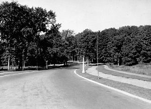
Island Park Drive
Encyclopedia
Ottawa
Ottawa is the capital of Canada, the second largest city in the Province of Ontario, and the fourth largest city in the country. The city is located on the south bank of the Ottawa River in the eastern portion of Southern Ontario...
, Ontario
Ontario
Ontario is a province of Canada, located in east-central Canada. It is Canada's most populous province and second largest in total area. It is home to the nation's most populous city, Toronto, and the nation's capital, Ottawa....
, Canada
Canada
Canada is a North American country consisting of ten provinces and three territories. Located in the northern part of the continent, it extends from the Atlantic Ocean in the east to the Pacific Ocean in the west, and northward into the Arctic Ocean...
. It is one of several parkway
Parkway
The term parkway has several distinct principal meanings and numerous synonyms around the world, for either a type of landscaped area or a type of road.Type of landscaped area:...
s in Ottawa administered by the National Capital Commission
National Capital Commission
The National Capital Commission , is a Canadian Crown corporation that administers the federally owned lands and buildings in Canada's National Capital Region, including Ottawa, Ontario and Gatineau, Quebec.The NCC was created in 1959, replacing the Federal District Commission , which had been...
providing scenic routes throughout Canada's capital region.
This street is lined with luxury homes and several embassies. The north end links up with the Ottawa River Parkway
Ottawa River Parkway
The Ottawa River Parkway is a four-lane scenic parkway along the Ottawa River in Ottawa, Ontario, Canada. It runs from Carling Avenue near Connaught Avenue, to Booth Street at the Canadian War Museum. It is maintained by the National Capital Commission. The speed limit is , enforced by the Royal...
and the Champlain Bridge
Champlain Bridge (Ottawa)
The Champlain Bridge crosses the Ottawa River about west of Parliament Hill, joining the communities of Ottawa, Ontario and Gatineau, Quebec. It is the westernmost link between the two cities....
, which crosses the Ottawa River
Ottawa River
The Ottawa River is a river in the Canadian provinces of Ontario and Quebec. For most of its length, it now defines the border between these two provinces.-Geography:...
into Gatineau
Gatineau
Gatineau is a city in western Quebec, Canada. It is the fourth largest city in the province. It is located on the northern banks of the Ottawa River, immediately across from Ottawa, Ontario, and together they form Canada's National Capital Region. Ottawa and Gatineau comprise a single Census...
, Quebec
Quebec
Quebec or is a province in east-central Canada. It is the only Canadian province with a predominantly French-speaking population and the only one whose sole official language is French at the provincial level....
. The road is named for Bate Island, the largest island crossed by the Champlain Bridge, which has a small park with road access. The south end leads to the Central Experimental Farm
Central Experimental Farm
The Central Experimental Farm is an agricultural facility, working farm, and research centre of the Research Branch of Agriculture and Agri-Food Canada. As the name indicates, this farm is centrally located in and completely surrounded by the City of Ottawa, Ontario, Canada...
, where it turns into the NCC Driveway.
Island Park Drive has a northbound offramp from the westbound Queensway
Queensway (Ottawa)
The Queensway is a major controlled-access freeway running through Ottawa, Ontario, Canada, from Kanata in the west to Orleans in the east. It is the primary east-west transportation artery in the Ottawa-Gatineau area....
and no other ramps. Hampton Park is north of the Queensway and borders Island Park Drive. Diplomats and other Island Park residents can frequently be seen in the park walking their dogs.
During the summer of 2007, the Highway 417 overpass was replaced using a rapid replacement technology technique which uses heavy lift and rolling equipment. This involved lifting out the old bridges and replacing them with new bridges that were built nearby. The full operation, which took about 15 hours, took place during the night of August 11 to August 12, 2007, and it is the first time in Canada that this method was used although it was previously used in other countries in the past including in the United States
United States
The United States of America is a federal constitutional republic comprising fifty states and a federal district...
. It was the first of two similar operations in the 417 corridors, the other being at a future date near the Carling Avenue
Carling Avenue
Carling Avenue is a major east-west arterial road in the west end of Ottawa, Ontario, Canada. It runs from March Road in Kanata to Bronson Avenue in the Glebe...
area. http://www.thepixelwarehouse.com/417/pdf/pic1notice_english.pdf http://www.canada.com/ottawacitizen/news/story.html?id=5441a660-43cb-4b5e-bf01-9eaf2418d3b4&k=25592
Commercial vehicles
Truck
A truck or lorry is a motor vehicle designed to transport cargo. Trucks vary greatly in size, power, and configuration, with the smallest being mechanically similar to an automobile...
are prohibited from Island Park Drive, which is a two-lane minor arterial road with a 40 km/h (25 mph) speed limit due to the residential nature and frequent sharp corners.