

James Bay Project
Encyclopedia
Hydro-Québec
Hydro-Québec is a government-owned public utility established in 1944 by the Government of Quebec. Based in Montreal, the company is in charge of the generation, transmission and distribution of electricity across Quebec....
by the on the La Grande
La Grande River
La Grande River is a river in northwestern Quebec, Canada, which rises in the highlands of north central Quebec and flows roughly west to drain into James Bay. It is the second largest river in Quebec, surpassed only by the Saint Lawrence River....
and other rivers of Northern Quebec
Nord-du-Québec
Nord-du-Québec is the largest of the seventeen administrative regions of Quebec, Canada. With , of which are lakes and rivers, it covers much of the Labrador Peninsula and about 55% of the total land surface area of Quebec....
.
Located in a largely unpopulated area 1000 kilometres (621.4 mi) north of Montreal
Montreal
Montreal is a city in Canada. It is the largest city in the province of Quebec, the second-largest city in Canada and the seventh largest in North America...
, the La Grande River watershed
Drainage basin
A drainage basin is an extent or an area of land where surface water from rain and melting snow or ice converges to a single point, usually the exit of the basin, where the waters join another waterbody, such as a river, lake, reservoir, estuary, wetland, sea, or ocean...
stretches over 177000 km² (68,340.1 sq mi) or approximately 11% of the total area of Quebec
Quebec
Quebec or is a province in east-central Canada. It is the only Canadian province with a predominantly French-speaking population and the only one whose sole official language is French at the provincial level....
, an area larger than the state of Florida
Florida
Florida is a state in the southeastern United States, located on the nation's Atlantic and Gulf coasts. It is bordered to the west by the Gulf of Mexico, to the north by Alabama and Georgia and to the east by the Atlantic Ocean. With a population of 18,801,310 as measured by the 2010 census, it...
or twice the size of Scotland
Scotland
Scotland is a country that is part of the United Kingdom. Occupying the northern third of the island of Great Britain, it shares a border with England to the south and is bounded by the North Sea to the east, the Atlantic Ocean to the north and west, and the North Channel and Irish Sea to the...
.
Construction costs of the of the project's first phase in the 1970s and 80s amounted to $13.7 billion (1987 Canadian dollar
Canadian dollar
The Canadian dollar is the currency of Canada. As of 2007, the Canadian dollar is the 7th most traded currency in the world. It is abbreviated with the dollar sign $, or C$ to distinguish it from other dollar-denominated currencies...
s). The 8 power stations of the La Grande Complex generate an average of 83 terawatt-hours (TWh) a year, enough to meet the total demand of a small industrialized economy such as Belgium
Belgium
Belgium , officially the Kingdom of Belgium, is a federal state in Western Europe. It is a founding member of the European Union and hosts the EU's headquarters, and those of several other major international organisations such as NATO.Belgium is also a member of, or affiliated to, many...
.
The James Bay power stations represent almost half of Hydro-Québec's total output and capacity.
The development of the James Bay Project led to an acrimonious conflict with the 5,000 Cree
Cree
The Cree are one of the largest groups of First Nations / Native Americans in North America, with 200,000 members living in Canada. In Canada, the major proportion of Cree live north and west of Lake Superior, in Ontario, Manitoba, Saskatchewan, Alberta and the Northwest Territories, although...
s of Northern Quebec over land rights, lifestyle and environmental issues. A ruling against the Quebec government in 1973 forced the Robert Bourassa government to negotiate a far-reaching agreement, the James Bay and Northern Quebec Agreement
James Bay and Northern Quebec Agreement
The James Bay And Northern Quebec Agreement was an Aboriginal land claim settlement, approved in 1975 by the Cree and Inuit of northern Quebec, and later slightly modified in 1978 by the Northeastern Quebec Agreement, through which Quebec's Naskapi First Nations joined the treaty...
, involving the Cree, the Naskapi
Naskapi
The Naskapi are the indigenous Innu inhabitants of an area they refer to as Nitassinan, which comprises most of what other Canadians refer to as eastern Quebec and Labrador, Canada....
First Nations, the Quebec and Canadian governments, Hydro-Québec and the SEBJ. In the 1990s, forceful opposition by the Crees and their environmental allies caused the cancellation of the Great Whale Project, a proposed 3,000 MW complex north of La Grande River.
In February 2002, the Bernard Landry
Bernard Landry
Bernard Landry, is a Quebec lawyer, teacher, politician, who served as the 28th Premier of Quebec , leader of the Opposition and leader of the Parti Québécois .-Personal:...
government and the Grand Council of the Crees
Grand Council of the Crees
The Grand Council of the Crees , or the GCC, is the political body that represents the approximately 16,357 Crees or “Iyyu” / “Iynu” of the Eeyou Istchee territory in the James Bay and Nunavik regions of Northern Quebec, Canada...
signed the Peace of the Braves
Agreement Respecting a New Relationship Between the Cree Nation and the Government of Quebec
The Agreement Respecting a New Relationship Between the Cree Nation and the Government of Quebec is an agreement between the Government of Quebec, Canada, and the Grand Council of the Crees...
and the Boumhounan Agreement, establishing a new relationship between Quebec and the Crees and agreeing on environmental rules for the construction of three new power stations built between 2003 and 2011 — the Eastmain-1, Eastmain-1-A and Sarcelle generating stations — and the diversion of the Rupert River
Rupert River
The Rupert River is one of the largest rivers in Quebec, Canada. From its headwaters in Lake Mistassini, the largest natural lake in Québec, it flows west into Rupert Bay on James Bay. The Rupert drains an area of . There is some extremely large whitewater on the river, but paddlers can avoid...
.
Geography
The James Bay region, also known as Jamésie, is a 350000 km² (135,136 sq mi) territory, bordered by the 49th and 55th parallels, James Bay on the western side and by the drainage divide with the Saint Lawrence River basin on the eastern side. The topography of the area consist of generally low relief areas and includes three parts: a 150 km (93.2 mi) coastal plainCoastal plain
A coastal plain is an area of flat, low-lying land adjacent to a seacoast and separated from the interior by other features. One of the world's longest coastal plains is located in eastern South America. The southwestern coastal plain of North America is notable for its species diversity...
, a rolling plateau
Plateau
In geology and earth science, a plateau , also called a high plain or tableland, is an area of highland, usually consisting of relatively flat terrain. A highly eroded plateau is called a dissected plateau...
with a maximum elevation of 400 m (1,312.3 ft) and the Otish Mountains to the east of the territory, with peaks reaching .
The area is part of the Canadian Shield
Canadian Shield
The Canadian Shield, also called the Laurentian Plateau, or Bouclier Canadien , is a vast geological shield covered by a thin layer of soil that forms the nucleus of the North American or Laurentia craton. It is an area mostly composed of igneous rock which relates to its long volcanic history...
and is largely made up of Precambrian
Precambrian
The Precambrian is the name which describes the large span of time in Earth's history before the current Phanerozoic Eon, and is a Supereon divided into several eons of the geologic time scale...
igneous
Igneous rock
Igneous rock is one of the three main rock types, the others being sedimentary and metamorphic rock. Igneous rock is formed through the cooling and solidification of magma or lava...
and metamorphic rock
Metamorphic rock
Metamorphic rock is the transformation of an existing rock type, the protolith, in a process called metamorphism, which means "change in form". The protolith is subjected to heat and pressure causing profound physical and/or chemical change...
s. Relief has been eroded
Erosion
Erosion is when materials are removed from the surface and changed into something else. It only works by hydraulic actions and transport of solids in the natural environment, and leads to the deposition of these materials elsewhere...
by successive glaciations
Quaternary glaciation
Quaternary glaciation, also known as the Pleistocene glaciation, the current ice age or simply the ice age, refers to the period of the last few million years in which permanent ice sheets were established in Antarctica and perhaps Greenland, and fluctuating ice sheets have occurred elsewhere...
in the Pleistocene
Pleistocene
The Pleistocene is the epoch from 2,588,000 to 11,700 years BP that spans the world's recent period of repeated glaciations. The name pleistocene is derived from the Greek and ....
era, as recently as 6,000 years ago, leaving depositions
Deposition (geology)
Deposition is the geological process by which material is added to a landform or land mass. Fluids such as wind and water, as well as sediment flowing via gravity, transport previously eroded sediment, which, at the loss of enough kinetic energy in the fluid, is deposited, building up layers of...
of loose materials: moraines, clay
Clay
Clay is a general term including many combinations of one or more clay minerals with traces of metal oxides and organic matter. Geologic clay deposits are mostly composed of phyllosilicate minerals containing variable amounts of water trapped in the mineral structure.- Formation :Clay minerals...
, silt
Silt
Silt is granular material of a size somewhere between sand and clay whose mineral origin is quartz and feldspar. Silt may occur as a soil or as suspended sediment in a surface water body...
and sand
Sand
Sand is a naturally occurring granular material composed of finely divided rock and mineral particles.The composition of sand is highly variable, depending on the local rock sources and conditions, but the most common constituent of sand in inland continental settings and non-tropical coastal...
and reshaped the hydrography
Drainage system (Geomorphology)
In geomorphology, a drainage system is the pattern formed by the streams, rivers, and lakes in a particular drainage basin. They are governed by the topography of the land, whether a particular region is dominated by hard or soft rocks, and the gradient of the land. Geomorphologists and...
of the territory.
The natural seismicity of the area is low. An earthquake
Earthquake
An earthquake is the result of a sudden release of energy in the Earth's crust that creates seismic waves. The seismicity, seismism or seismic activity of an area refers to the frequency, type and size of earthquakes experienced over a period of time...
of magnitude 5 on the Richter scale occurred in 1941, its epicenter located approximately 150 km from the La Grande-3 generating station. However, episodes of induced seismicity
Induced seismicity
Induced seismicity refers to typically minor earthquakes and tremors that are caused by human activity that alters the stresses and strains on the Earth's crust. Most induced seismicity is of an extremely low magnitude...
occurred during the initial fill of reservoir
Reservoir
A reservoir , artificial lake or dam is used to store water.Reservoirs may be created in river valleys by the construction of a dam or may be built by excavation in the ground or by conventional construction techniques such as brickwork or cast concrete.The term reservoir may also be used to...
s. In 1983, a 4 magnitude tremor was recorded 50 km (31.1 mi) upstream of LG-3's main dam.
The region's climate is subarctic
Subarctic climate
The subarctic climate is a climate characterized by long, usually very cold winters, and short, cool to mild summers. It is found on large landmasses, away from the moderating effects of an ocean, generally at latitudes from 50° to 70°N poleward of the humid continental climates...
. Winters are long and last, on average, from October 22 to May 4. Summers are short and mild, with temperatures averaging 13.6 °C (56.5 °F) in July, while dropping to -22.9 C in January. Annual precipitation average 765 mm (30.1 in), a third in snow. Highest monthly rainfalls are registered in the summer and snow depth varies from in the winter. Precipitations are significantly lower than the annual average of 1050 mm (41.3 in) recorded in Montreal.
Exploration
Between 1950 and 1959, a team led by H. M. Finlayson conducted water surveys of the NottawayNottaway River
The Nottaway River is a river in Quebec, Canada. The river drains Lake Matagami and travels north-west before emptying into Rupert Bay at the south end of James Bay. Its drainage basin is and has a mean discharge of 1190 m³/s...
, Broadback
Broadback River
The Broadback River is a river in northern Quebec, Canada. It drains into Rupert Bay , just south of the Rupert River and Cree community Waskaganish...
and Rupert River
Rupert River
The Rupert River is one of the largest rivers in Quebec, Canada. From its headwaters in Lake Mistassini, the largest natural lake in Québec, it flows west into Rupert Bay on James Bay. The Rupert drains an area of . There is some extremely large whitewater on the river, but paddlers can avoid...
s—collectively known by the abbreviation NBR—on behalf of the Shawinigan Water & Power Company, a large investor-owned utility based in Shawinigan, Quebec
Shawinigan, Quebec
Shawinigan is a city located on the Saint-Maurice River in the Mauricie area in Quebec, Canada. It has a population of approximately 51,904 people ....
. Among options studied by Shawinigan's engineers was the possible diversion of these rivers to the Saint-Maurice River
Saint-Maurice River
The Saint-Maurice River is a river in central Quebec which flows south from Gouin Reservoir to empty into the Saint Lawrence River at Trois-Rivières, Quebec. The river is 563 km in length and has a drainage basin of 43,300 km² ....
watershed in order to increase output at the company's 8 power stations.
With the nationalization of privately owned utilies in 1963
History of Hydro-Québec
Hydro-Québec is a government-owned public utility established in 1944 by the Government of Quebec. The company is in charge of the generation, transmission and distribution of electricity across Quebec. Its head office is located in Montreal.-Origins:...
, Hydro-Québec inherited the preliminary studies conducted by Finlayson and his team on the hydroelectric potential of James Bay rivers. However, other projects, such as the Manicouagan-Outardes project on the North Shore
Côte-Nord
Côte-Nord is the second largest administrative region by land area in Quebec, Canada, after Nord-du-Québec...
and the possibility of building a large power station at Churchill Falls
Churchill Falls Generating Station
The Churchill Falls Generating Station is a hydroelectric power station located on the Churchill River in Newfoundland and Labrador. The underground power station can generate 5,428 MW, which makes it the second-largest in Canada, after the Robert-Bourassa generating station. The generating station...
in Labrador
Labrador
Labrador is the distinct, northerly region of the Canadian province of Newfoundland and Labrador. It comprises the mainland portion of the province, separated from the island of Newfoundland by the Strait of Belle Isle...
proved easier and less expensive and the Crown corporation devoted only mimimal resources to the vast potential of northern rivers. In 1965, Hydro-Québec survey program included exploration of the territory and hydrographic surveys of areas between the 52nd and 55th parallel.
In 1967, the company stepped up the work on the La Grande
La Grande River
La Grande River is a river in northwestern Quebec, Canada, which rises in the highlands of north central Quebec and flows roughly west to drain into James Bay. It is the second largest river in Quebec, surpassed only by the Saint Lawrence River....
and Eastmain rivers
Eastmain River
The Eastmain River is a river in northwestern Quebec which rises in north central Quebec and flows 800 km west to drain into James Bay. 'East Main' is an old name for the east side of James Bay. This river drains an area of 46,400 km²...
. Dozens, then hundred of people were sent by helicopter and seaplanes in inaccessible areas of the taiga
Taiga
Taiga , also known as the boreal forest, is a biome characterized by coniferous forests.Taiga is the world's largest terrestrial biome. In North America it covers most of inland Canada and Alaska as well as parts of the extreme northern continental United States and is known as the Northwoods...
to perform surveys and geological studies to identify potential sites for hydropower development. Faced with budget concerns, Hydro-Québec did cut back exploration budgets between 1968 and 1970, but the company maintained planning and analysis work, since early data showed a large potential for development.
Early steps
On December 16, 1969, Liberal backbencherBackbencher
In Westminster parliamentary systems, a backbencher is a Member of Parliament or a legislator who does not hold governmental office and is not a Front Bench spokesperson in the Opposition...
Member of the National Assembly Robert Bourassa
Robert Bourassa
Jean-Robert Bourassa, was a politician in Quebec, Canada. He served as the 22nd Premier of Quebec in two different mandates, first from May 12, 1970, to November 25, 1976, and then from December 12, 1985, to January 11, 1994, serving a total of just under 15 years as Provincial Premier.-Early...
met with the president of Hydro-Québec, Roland Giroux
Roland Giroux
Roland Giroux, was from 1969 to 1977 the Chairman of the Quebec Hydro-Electric Commission ....
over lunch at the parliamentary dining room in Quebec City
Quebec City
Quebec , also Québec, Quebec City or Québec City is the capital of the Canadian province of Quebec and is located within the Capitale-Nationale region. It is the second most populous city in Quebec after Montreal, which is about to the southwest...
. After the meeting, Bourassa who is about to launch a leadership bid for the position left vacant by the resignation of former Premier Jean Lesage
Jean Lesage
Jean Lesage, PC, CC, CD was a lawyer and politician in Quebec, Canada. He served as the 19th Premier of Quebec from 22 June 1960, to 16 August 1966...
, became convinced of the probability and suitability of the project and made the development of James Bay hydroelectricity a major plank of its leadership campaign. Elected as the party leader in January, Bourassa went on to win the April 29, 1970 general election
Quebec general election, 1970
The Quebec general election of 1970 was held on April 29, 1970 to elect members of the National Assembly of Quebec, Canada. The former Legislative Assembly had been renamed the "National Assembly" in 1968...
, and his tenure as Premier of Quebec became closely linked to hydroelectric development in general and with the James Bay project in particular.
For Bourassa, the development of James Bay project addressed two of his priorities. In Energy in the North, an essay published in 1985, Bourassa, an economist
Economist
An economist is a professional in the social science discipline of economics. The individual may also study, develop, and apply theories and concepts from economics and write about economic policy...
by trade, argued that "Quebec's economic development relies on the development of its natural resources". Moreover, argued Bourassa, his 1969 estimates showed demand for electricity would outstrip supply by 11,000 MW by 1983, concurring with forecasts made at the time by Hydro-Quebec.
Six months after his election, Bourassa began working on the details of the scheme with his adviser, financier Paul Desrochers. The two men met secretly with Roland Giroux and Robert A. Boyd
Robert A. Boyd
Robert A. Boyd, CM, OQ was a Canadian electric engineer and utility executive. He successfully led the construction of first phase of the James Bay hydroelectric project, a large dam complex built in northern Quebec by Hydro-Québec during the 1970s and early 1980s.Born in Sherbrooke in the Eastern...
for an update in September 1970 and the next month he travelled to New York City
New York City
New York is the most populous city in the United States and the center of the New York Metropolitan Area, one of the most populous metropolitan areas in the world. New York exerts a significant impact upon global commerce, finance, media, art, fashion, research, technology, education, and...
in the midst of the October Crisis
October Crisis
The October Crisis was a series of events triggered by two kidnappings of government officials by members of the Front de libération du Québec during October 1970 in the province of Quebec, mainly in the Montreal metropolitan area.The circumstances ultimately culminated in the only peacetime use...
to negotiate financing for the project, estimated at the time to cost between $5 to $6 billion.
Bourassa introduced his plan to the provincial cabinet in March 1971 and recommended hiring the U.S.
United States
The United States of America is a federal constitutional republic comprising fifty states and a federal district...
engineering
Engineering
Engineering is the discipline, art, skill and profession of acquiring and applying scientific, mathematical, economic, social, and practical knowledge, in order to design and build structures, machines, devices, systems, materials and processes that safely realize improvements to the lives of...
firm Bechtel
Bechtel
Bechtel Corporation is the largest engineering company in the United States, ranking as the 5th-largest privately owned company in the U.S...
to oversee the construction. Liberal strategists then chose to make the announcement before a partisan crowd assembled at Quebec's Little Coliseum as part of the Liberal party gathering celebrating the first year of Bourassa's term, on April 30, 1971. According to journalists witnessing the scene, Bourassa's speech concluded on a scene of indescribable enthusiasm.
Nuclear lobby
The announcement quickly generated a public debate on the wisdom to engage the province on such a large-scale project. For several years, a lobby spearheaded by the Canadian governmentGovernment of Canada
The Government of Canada, formally Her Majesty's Government, is the system whereby the federation of Canada is administered by a common authority; in Canadian English, the term can mean either the collective set of institutions or specifically the Queen-in-Council...
and its nuclear venture, Atomic Energy of Canada Limited
Atomic Energy of Canada Limited
Atomic Energy of Canada Limited or AECL is a Canadian federal Crown corporation and Canada's largest nuclear science and technology laboratory...
, promoted the adoption of nuclear energy in Quebec, as a way to "share the benefits of Canada with our fellow francophone citizens", as Canadian Prime Minister
Prime Minister of Canada
The Prime Minister of Canada is the primary minister of the Crown, chairman of the Cabinet, and thus head of government for Canada, charged with advising the Canadian monarch or viceroy on the exercise of the executive powers vested in them by the constitution...
Lester B. Pearson
Lester B. Pearson
Lester Bowles "Mike" Pearson, PC, OM, CC, OBE was a Canadian professor, historian, civil servant, statesman, diplomat, and politician, who won the Nobel Peace Prize in 1957 for organizing the United Nations Emergency Force to resolve the Suez Canal Crisis...
said. The lobby had its supporters within the ranks at Hydro-Québec, and has been vocal when the provincial government made the decision to invest in the Churchill Falls venture with Brinco
British Newfoundland Development Corporation
The British Newfoundland Development Corporation, or BRINCO was incorporated by a consortium of British companies in 1953 which undertook industrial development opportunities in the Canadian province of Newfoundland and Labrador...
. Several Parti Québécois
Parti Québécois
The Parti Québécois is a centre-left political party that advocates national sovereignty for the province of Quebec and secession from Canada. The Party traditionally has support from the labour movement. Unlike many other social-democratic parties, its ties with the labour movement are informal...
spokesmen, including energy critic Guy Joron
Guy Joron
-Background:He was born on June 2, 1940 in Montreal. He has a B.A. in political science from Université de Montréal.-Member of the legislature:Joron successfully ran as a Parti Québécois candidate to the National Assembly of Quebec in the district of Gouin in 1970, defeating Liberal incumbent Yves...
and economic adviser Jacques Parizeau
Jacques Parizeau
Jacques Parizeau, is an economist and noted Quebec sovereignist who was the 26th Premier of the Canadian province of Quebec from September 26, 1994 to January 29, 1996.-Early life and career:...
voiced their opposition to the Bourassa scheme. In an interview to Montreal
Montreal
Montreal is a city in Canada. It is the largest city in the province of Quebec, the second-largest city in Canada and the seventh largest in North America...
's Le Devoir
Le Devoir
Le Devoir is a French-language newspaper published in Montreal and distributed in Quebec and the rest of Canada. It was founded by journalist, politician, and nationalist Henri Bourassa in 1910....
, the former economist and public servant who later became premier of Quebec, gets sarcastic: "We don't have to dam every single river just because they're French Canadian and catholic", he quipped.
However, Bourassa himself and Hydro-Québec senior management — including President Roland Giroux and commissioners Yvon DeGuise and Robert Boyd — are firmly behind the large hydroelectric development to be built in northern Quebec. At the time Giroux, a financier, argued that large international investors "are still wary about nuclear energy. If we bring them a good hydroelectric project, and James Bay is a good one, they'll soon show where their preferences lie". As an engineer, Boyd expressed concerns at this early date about the uncertainty of nuclear energy. He recommended maintaining a certain expertise in the field but advocated delaying nuclear expansion as late as possible.
the Quebec premier received an unexpected backing when the Chairman of the Council of Ministers of the USSR, Alexei Kosygin visited Montreal in October 1971. Kosygin supported Bourassa's project and expressed concerns regarding his country's own nuclear power, explaining his country had to develop the technology because the USSR lacked suitable rivers to expand its own hydroelectric network of dams and power stations.
Options
Two options were considered when Bourassa unveiled his plan for the construction of several large hydroelectric power stations on the rivers flowing into James Bay, either on the NottawayNottaway River
The Nottaway River is a river in Quebec, Canada. The river drains Lake Matagami and travels north-west before emptying into Rupert Bay at the south end of James Bay. Its drainage basin is and has a mean discharge of 1190 m³/s...
, Broadback
Broadback River
The Broadback River is a river in northern Quebec, Canada. It drains into Rupert Bay , just south of the Rupert River and Cree community Waskaganish...
, Rupert
Rupert River
The Rupert River is one of the largest rivers in Quebec, Canada. From its headwaters in Lake Mistassini, the largest natural lake in Québec, it flows west into Rupert Bay on James Bay. The Rupert drains an area of . There is some extremely large whitewater on the river, but paddlers can avoid...
and Harricana River
Harricana River
The Harricana River is a river in western Quebec and northeastern Ontario, Canada. It is long, has a drainage area of , and has a mean discharge of 570 m³/s...
s in the south (NBR Project), or on the La Grande and Eastmain River
Eastmain River
The Eastmain River is a river in northwestern Quebec which rises in north central Quebec and flows 800 km west to drain into James Bay. 'East Main' is an old name for the east side of James Bay. This river drains an area of 46,400 km²...
s to the north. The northerly rivers were selected in May 1972, various studies conducted by engineering firms having concluded the La Grande option would be more cost effective, while having a lesser impact on forestry and would require less flooding, thus minimizing impacts on First Nations fishing and hunting. Another area of concern was the silt
Silt
Silt is granular material of a size somewhere between sand and clay whose mineral origin is quartz and feldspar. Silt may occur as a soil or as suspended sediment in a surface water body...
y nature of the terrain in the NBR area, which would have complicated the damming.
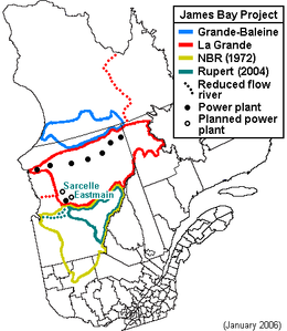
The project, as described at the time, would involve the construction of four generating stations on the La Grande River and the diversion of the Eastmain and Caniapiscau
Caniapiscau River
The Caniapiscau River is a tributary of the Koksoak River in Nunavik, Quebec, Canada. In Cree the name of the river means rocky point.Starting from Lac Sevestre on the Canadian Shield, the Caniapiscau River flows northward through a wide, timbered glacial valley until it makes a sharp turn at its...
rivers into the La Grande watershed. Responsibility for the project would be overseen by the Société d'énergie de la Baie-James, a newly created mixed corporation (public/private) controlled by Hydro-Québec
Hydro-Québec
Hydro-Québec is a government-owned public utility established in 1944 by the Government of Quebec. Based in Montreal, the company is in charge of the generation, transmission and distribution of electricity across Quebec....
, headed by Robert A. Boyd
Robert A. Boyd
Robert A. Boyd, CM, OQ was a Canadian electric engineer and utility executive. He successfully led the construction of first phase of the James Bay hydroelectric project, a large dam complex built in northern Quebec by Hydro-Québec during the 1970s and early 1980s.Born in Sherbrooke in the Eastern...
.
Although the Aboriginal
Indigenous peoples of the Americas
The indigenous peoples of the Americas are the pre-Columbian inhabitants of North and South America, their descendants and other ethnic groups who are identified with those peoples. Indigenous peoples are known in Canada as Aboriginal peoples, and in the United States as Native Americans...
Cree
Cree
The Cree are one of the largest groups of First Nations / Native Americans in North America, with 200,000 members living in Canada. In Canada, the major proportion of Cree live north and west of Lake Superior, in Ontario, Manitoba, Saskatchewan, Alberta and the Northwest Territories, although...
s had traditional hunting and trapping areas in the region, no seasonal or permanent roads existed at the time. Opposition to the project, however, was strong among the 5,000 Crees of James Bay, the 3,500 Inuit
Inuit
The Inuit are a group of culturally similar indigenous peoples inhabiting the Arctic regions of Canada , Denmark , Russia and the United States . Inuit means “the people” in the Inuktitut language...
to the north and several environmental groups. They believed the government of Quebec was acting in violation of treaties and committing unlawful expropriation and destruction of traditional hunting and trapping lands. Furthermore, the Cree and Inuit had not been informed of the hydroelectric project until after construction of the access road had begun. In later years, the Cree and Inuit were given a settlement of $150 million, negotiated by Cree chief Billy Diamond.
In November 1975, the governments of Canada and Quebec signed the James Bay and Northern Quebec Agreement
James Bay and Northern Quebec Agreement
The James Bay And Northern Quebec Agreement was an Aboriginal land claim settlement, approved in 1975 by the Cree and Inuit of northern Quebec, and later slightly modified in 1978 by the Northeastern Quebec Agreement, through which Quebec's Naskapi First Nations joined the treaty...
with the Cree of the James Bay region and the Inuit of northern Quebec, granting exclusive hunting and fishing rights to about 170,000 km² of territory and about $250 million in financial compensation in return for the right to develop the hydroelectric resources of Northern Quebec. The planned La Grande-1 power station would be built about 50 km further away from the Cree village of Chisasibi than originally planned. The Agreement also provided for an extensive environmental follow-up of all aspects of the hydroelectric development on the La Grande and Eastmain rivers and the establishment of a joint environmental assessment process for any future hydroelectric project involving other rivers of Northern Quebec.
Phase I
The period of construction of the first phase of the project covered about 14 years. By 1986, the largest power stations and reservoirs on the La Grande River were mostly completed, including the Robert-BourassaRobert-Bourassa generating station
The Robert-Bourassa generating station is a hydroelectric power station on the La Grande River that is part of Hydro-Québec's James Bay Project in Canada...
(originally named La Grande-2), La Grande-3 and La Grande-4 generating stations, with an installed capacity of 10,800 MW, and five reservoirs covering an area of 11,300 km². The Eastmain and Caniapiscau river diversions each added about 800 m³/s of water to the La Grande River. The power plants of the first phase of the James Bay Project produce about 65 TWh of power each year, operating at about 60% of their maximum rated generating capacity.
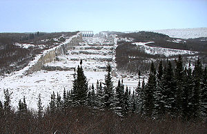
During this first phase of construction, over 155,000,000 m³ (203 million cubic yards) of fill, 138,000 tons of steel, 550,000 tons of cement, and nearly 70,000 tons of explosives were used. Concurrent employment by the project reached 18,000. Of the 215 dikes and dams, many surpassed the height of skyscrapers, with one reaching 56 stories. The terraced diversion channel at Robert-Bourassa generating station
Robert-Bourassa generating station
The Robert-Bourassa generating station is a hydroelectric power station on the La Grande River that is part of Hydro-Québec's James Bay Project in Canada...
was carved 30 m (one hundred feet) deep into the side of a mountain. Water tumbles from the reservoir to the river below at a height greater than that of Niagara Falls. A 4800 km (2,982.6 mi) network of transmission lines was necessary to bring generated power to consumers in southern Quebec. The network contains several 735-kilovolt lines and one 450-kilovolt DC line directly linked to the U.S. power grid.
Phase II
During the late 1980s and early 1990s, construction of the second phase of the James Bay project centred on the construction of five secondary power plants on the La Grande River and its tributaries (La Grande-1, La Grande-2A, Laforge-1, Laforge-2 and Brisay), adding a further 5,200 MW of generating capacity by the end of 1996. Three new reservoirs covering an area of 1,600 km² were created, including the Laforge-1 Reservoir covering 1,288 km². The generating plants of this second phase of the project produce about 18.9 TWh of power per year, operating at between 60% and 70% of their maximum rated generating capacity.On March 13, 1989, a massive solar storm
Geomagnetic storm
A geomagnetic storm is a temporary disturbance of the Earth's magnetosphere caused by a disturbance in the interplanetary medium. A geomagnetic storm is a major component of space weather and provides the input for many other components of space weather...
caused a failure of the La Grande complex which plunged most of Quebec into darkness for nine hours.
Great Whale River project
During the construction of the second phase of the James Bay Project, Hydro-Québec proposed an additional project on the Great Whale RiverGreat Whale River
The Great Whale River is a river in Nunavik, Quebec, Canada. It flows from Lac Saint-Luson through Lac Bienville west to Hudson Bay...
(French: Grande rivière de la Baleine), just to the north of the La Grande River watershed. Opposition among the Cree was even more vocal this time than in the early 1970s. In 1990, Grand Chief Matthew Coon Come
Matthew Coon Come
Matthew Coon Come is a Canadian politician and activist of Cree descent. He was National Chief of the Assembly of First Nations from 2000 to 2003.Born near Mistissini, Quebec, Coon Come was first educated in a residential school...
organized a canoe trip from Hudson Bay
Hudson Bay
Hudson Bay , sometimes called Hudson's Bay, is a large body of saltwater in northeastern Canada. It drains a very large area, about , that includes parts of Ontario, Quebec, Saskatchewan, Alberta, most of Manitoba, southeastern Nunavut, as well as parts of North Dakota, South Dakota, Minnesota,...
to the Hudson River
Hudson River
The Hudson is a river that flows from north to south through eastern New York. The highest official source is at Lake Tear of the Clouds, on the slopes of Mount Marcy in the Adirondack Mountains. The river itself officially begins in Henderson Lake in Newcomb, New York...
, in Albany, New York
Albany, New York
Albany is the capital city of the U.S. state of New York, the seat of Albany County, and the central city of New York's Capital District. Roughly north of New York City, Albany sits on the west bank of the Hudson River, about south of its confluence with the Mohawk River...
, and this very effective public relations stunt brought international pressure to bear on the government of Quebec. The Cree had experienced considerable culture shock with the introduction of permanent transportation routes to the south and very few Cree were employed on the construction site. Poverty and social problems remained important in the isolated Cree and Inuit villages of Northern Quebec, even in areas where there were no hydroelectric or mining activities.
By the 1980s, the natural ebb and flow of the La Grande, Eastmain
Eastmain River
The Eastmain River is a river in northwestern Quebec which rises in north central Quebec and flows 800 km west to drain into James Bay. 'East Main' is an old name for the east side of James Bay. This river drains an area of 46,400 km²...
and Caniapiscau
Caniapiscau River
The Caniapiscau River is a tributary of the Koksoak River in Nunavik, Quebec, Canada. In Cree the name of the river means rocky point.Starting from Lac Sevestre on the Canadian Shield, the Caniapiscau River flows northward through a wide, timbered glacial valley until it makes a sharp turn at its...
rivers had been severely modified, notably delaying the formation of a solid ice cover near the Cree village of Chisasibi
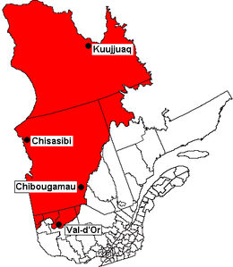
Chisasibi, Quebec
Chisasibi is a village on the eastern shore of James Bay, in the Eeyou Istchee territory in northern Quebec, Canada. It is situated on the south shore of La Grande River , less than from the river's mouth...
, and about 4% of the traditional hunting and trapping territories of the Cree had been lost to the rising waters of the reservoirs, including about 10% of the territories of the Cree village of Chisasibi. At the same time, new roads, snowmobiles and bush airlines facilitated access to distant hunting territories of the interior. While highly motivated, the Cree's opposition to the Great Whale River Project was mainly ineffective until 1992 when the State of New York withdrew from a multi-billion dollar power purchasing agreement due to public outcry and a decrease in energy requirements. In 1994, the Government of Quebec and Hydro-Québec suspended the project indefinitely.
Rupert River diversion
In 2002, the Quebec government and the Grand Council of the Crees signed a landmark agreement, "La Paix des Braves" (literally "The Peace of the Braves"), ensuring the completion of the last phase of the original James Bay Project: construction of the Eastmain-1 generating station, with a capacity of 480 MW, and the Eastmain ReservoirEastmain Reservoir
The Eastmain Reservoir is a reservoir which lies about 800 kilometres north of Montreal. The reservoir is part of a project known as the Eastmain-1-A/Sarcelle/Rupert Project which is designed to increase hydroelectric power for the Canadian province...
with a surface area of about 600 km².
A subsequent agreement in April 2004 put an end to all litigation between the two parties and opened the way to a joint environmental assessment of the projected diversion of the Rupert River
Rupert River
The Rupert River is one of the largest rivers in Quebec, Canada. From its headwaters in Lake Mistassini, the largest natural lake in Québec, it flows west into Rupert Bay on James Bay. The Rupert drains an area of . There is some extremely large whitewater on the river, but paddlers can avoid...
, to the south of the Eastmain River. The project entails the diversion of about 50% of the total water flow of the Rupert River (and 70% of the flow at the diversion point) towards the Eastmain Reservoir and into the La Grande Complex, and the construction of two additional generating stations: Eastmain-1A and Sarcelle, with a combined capacity of 888 MW. The Rupert diversion would generate a total of 8.5 TWh of electricity at the new and existing power stations.
The Grand Chief of the Crees of Quebec, Matthew Mukash, http://www.radio-canada.ca/actualite/v2/dimanchemag/niveau2_5256.shtml elected in late 2005, is opposed to the Rupert River diversion and favours the construction of wind turbines.
Hydro-electric installations
The hydro-electric stations in the La Grande watershed are:- La Grande-1 generating stationLa Grande-1 generating stationThe La Grande-1 is a hydroelectric power station on the La Grande River that is part of Hydro-Québec's James Bay Project. The station can generate 1,436 MW and was commissioned in 1994–1995...
- Robert-Bourassa generating stationRobert-Bourassa generating stationThe Robert-Bourassa generating station is a hydroelectric power station on the La Grande River that is part of Hydro-Québec's James Bay Project in Canada...
(formerly La Grande-2) - La Grande-2-A generating stationLa Grande-2-A generating stationThe La Grande-2-A is a hydroelectric power station on the La Grande River that is part of Hydro-Québec's James Bay Project. The station can generate 2,106 MW and was commissioned in 1991–1992. Together with the adjacent Robert-Bourassa generating station, it uses the reservoir and dam system...
- La Grande-3 generating stationLa Grande-3 generating stationThe La Grande-3 or LG-3 is a hydroelectric dam on the La Grande River in northern Quebec, part of Hydro-Québec's James Bay Project. The station can generate 2,418 MW and was commissioned in 1982-1984. It generates electricity through the reservoir and dam system. The dam and reservoir both are...
- La Grande-4 generating stationLa Grande-4 generating stationThe La Grande-4 is a hydroelectric generating station on the La Grande River that is part of Hydro-Québec's James Bay Project. The station can generate 2,779 MW and was commissioned in 1984–1986...
- Laforge-1 generating stationLaforge-1 generating stationThe Laforge-1 is a hydroelectric power station on the Laforge River, a tributary of the La Grande River, and is part of Hydro-Québec's James Bay Project. The station can generate 878 MW and was commissioned in 1993-1994. It generates electricity through the reservoir and dam system.- External links...
- Laforge-2 generating stationLaforge-2 generating stationThe Laforge-2 is a hydroelectric generating station on the Laforge River, a tributary of the La Grande River, and is part of Hydro-Québec's James Bay Project. The station can generate 319 MW and was commissioned in 1996. It is considered a "run of the river" generating station since the Laforge-2...
- Brisay generating stationBrisay generating stationThe Brisay hydroelectric power station is on the Caniapiscau Reservoir, in the Canadian province of Quebec. Part of Hydro-Québec's James Bay Project, the station can generate 469 MW and was commissioned in 1993. It generates electricity through the reservoir and dam system.- See also :* List of...
- Eastmain-1 generating station
- Eastmain-1-A generating station (under construction)
- Sarcelle generating station (under construction)
Environmental impact
Since its initial construction phase in the 1970s, the James Bay Project has created a complex chain reservoir by integrating all the watersheds of the eastern shores of the Hudson Bay from the southern tip of James Bay to Ungava Bay in the north, diverting the flow of water from four major rivers into its large body of water, ultimately changing the dynamics of the land, an environmental political phenomenon often regarded as a "first build, then paint green," policy. Two of these main diverted rivers are the Caniapiscau and Eastmain rivers into which the James Bay Project submerged about 11,000 km² of boreal forest and substantially modified the water flow of the La Grande River. The water flow was reduced by 90% at the mouth of the Eastmain River, near the Cree village of Eastmain, by 45% where the Caniapiscau River flows into the Koksoak RiverKoksoak River
The Koksoak River is a river in northern Quebec, Canada, the largest river in the Nunavik region. The Inuit village and region's administrative center Kuujjuaq lies on the shores of the Koksoak, about south from its mouth.The name Koksoak is believed to originate from Moravian missionaries who...
, and by 35% at the mouth of the Koksoak River, near the northern village of Kuujjuaq
Kuujjuaq, Quebec
Kuujjuaq is the largest Inuit village in Nunavik, Quebec, Canada with a population of 2,132 as of the 2006 census. This is up roughly 10% from 1,932 as of the 2001 Census. It is the administrative capital of Nunavik and lies on the western shore of the Koksoak River.Kuujjuaq previously was known...
. The water flow of the La Grande River, on the other hand, was doubled, increasing from 1,700 m³/s to 3,400 m³/s (and from 500 m³/s to 5,000 m³/s in winter) near the Cree village of Chisasibi
Chisasibi, Quebec
Chisasibi is a village on the eastern shore of James Bay, in the Eeyou Istchee territory in northern Quebec, Canada. It is situated on the south shore of La Grande River , less than from the river's mouth...
at the mouth of the La Grande River. The planned diversion of the Rupert River
Rupert River
The Rupert River is one of the largest rivers in Quebec, Canada. From its headwaters in Lake Mistassini, the largest natural lake in Québec, it flows west into Rupert Bay on James Bay. The Rupert drains an area of . There is some extremely large whitewater on the river, but paddlers can avoid...
into the La Grande Complexe will further increase the flow of the La Grande River by about 420 m³/s; the flow of the Rupert River will, on the other hand, be reduced from 840 m³/s to about 420 m³/s at its mouth, near the Cree village of Waskaganish
Waskaganish, Quebec
Waskaganish is a Cree village of about 2000 people at the mouth of the Rupert River on the south-east shore of James Bay in the Eeyou Istchee territory in Northern Quebec, Canada...
.
Other environmental impacts of the James Bay Project can be associated with geological tremors and drastic change in the physical layout of the land. The resultant fluctuating water levels as previously described affect areas of ecological importance, filling shorelines with considerable dead trees. Any shoreline plants that could potentially provide vegetation growth to replace any of the lost wetland habitats in these zones of periodic fluctuations are destroyed. Moreover, the James Bay Project is subject to earth tremors near the hydroelectric dams. This phenomenon is caused by the colossal weight of the artificial river, resulting in the shift of layers of rock, and although officials state that the reservoirs are only shallow lakes and the occurrence of such disaster is remote at best, these geological tremors could potentially fatally harm Quebec's local population and surrounding environment, as the region is typically dominated by slump-sensitive clays, and fault lines present in the St. Lawrence Valley.
Decomposing organic material in the reservoirs further added to the high levels of methyl mercury (a highly bio-accumulative environmental toxin) in local lakes and rivers, a growing concern to many environmentalists that stems from geology and atmospheric pollution from the coal-fired electric generation plants of the United States and Ontario
Ontario
Ontario is a province of Canada, located in east-central Canada. It is Canada's most populous province and second largest in total area. It is home to the nation's most populous city, Toronto, and the nation's capital, Ottawa....
, Canada, but this impact has been shown to dissipate after 20 to 30 years. Increased levels of mercury in bodies of water however, could still potentially be harmful, as methyl mercury is formed in aquatic systems and because it is not readily eliminated from organisms, it is bio-magnified in aquatic food chains. Thus, methyl mercury concentrations steadily increase through the food chain, and if ingested by humans, it could lead to mercury poisoning.
Other changes in the delicate balance of the James Bay ecosystem can be illustrated through the animal migration patterns, salmon spawning, and destruction of wildlife habitats. Diverting rivers towards the James Bay could cause changes in the geographical pattern of river water discharge into the sea, affecting major salmon spawning in the Larch River and beaver habitats. Furthermore, caribou population who has been expanding since the 1950s have adopted migration routes throughout much of the Quebec-Labrador Peninsula, its members increasingly found in the James Bay area, the valley of the Caniapiscau, and around George River. Important variations in the water flow of the Caniapiscau River from 1981 to 1984, during the period when the Caniapiscau Reservoir
Caniapiscau Reservoir
The Caniapiscau Reservoir is a reservoir on the upper Caniapiscau River in the Côte-Nord administrative region of the Canadian province of Quebec...
was being filled, may have contributed to the death of 10,000 caribou
Migratory Woodland Caribou
The migratory woodland caribou , also known as the forest caribou or woodland caribou , is a subspecies of the caribou...
in September 1984 (about 1.5 percent of the herd at that time). Traditionally a migration pattern for years, but the subsequent fast raging tumult of the water proved too much and led to their death. However, the reduced flow of the Caniapiscau and Koksoak rivers has permanently reduced the risk of natural floods on the lower Caniapiscau during the period of caribou migrations. About 30,000 caribou are killed each year by Inuit, Cree and southern hunters, mostly American and European. Furthermore, seasonal reversal in the flow of rivers can potentially rob the rich nutrients that thrive in various tidal flats and coastal marshes, affecting millions of migratory birds such as waterfowls, Canadian geese, and various inland birds that use the coastlines of both the James and Hudson Bays during their spring and fall migrations.
The potential for massive greenhouse gas emissions in large hydroelectric reservoirs has also generated considerable debate since the Kyoto conference on climate change
Kyoto Protocol
The Kyoto Protocol is a protocol to the United Nations Framework Convention on Climate Change , aimed at fighting global warming...
of 1997. However, greenhouse gas emissions from the northern reservoirs of the La Grande complex are between 2 and 8 percent of the emissions associated with any conventional (fossil fuel) power generation (and from 1 to 4 percent of the greenhouse emissions of the typical coal-fired power generation plant of Canada or the United States).
Social impact
The James Bay and Northern Quebec Agreement was a milestone on the road to economic and social modernisation in the Cree and Inuit communities of Quebec. At a time when hunting and fishing activities had been on the decline in the Cree villages, the James Bay Project provided considerable financial and administrative resources for the Crees to deal with the environmental and social consequences of the project and provide for future economic development, such as the creation of the local airline Air CreebecAir Creebec
Air Creebec Inc. is a regional airline based in Val-d'Or, Quebec, Canada. It operates scheduled and charter services to 16 destinations in Quebec and Ontario. Its main base is Val-d'Or Airport, with a hub at Timmins/Victor M. Power Airport.- History :...
. The James Bay Project also was an impetus for the forging of a collective identity among the Cree of Quebec and for the establishment of the Grand Council of the Crees (Eeyou Istchee)
Grand Council of the Crees
The Grand Council of the Crees , or the GCC, is the political body that represents the approximately 16,357 Crees or “Iyyu” / “Iynu” of the Eeyou Istchee territory in the James Bay and Nunavik regions of Northern Quebec, Canada...
. The Agreement notably provided for major institutional structures for local government, economic development, schools and health services, mostly under the control of the Grand Council of the Crees and the Kativik Regional Government
Kativik Regional Government
Kativik redirects here. For the statistical area, see Kativik .The Kativik Regional Government encompasses most of the Nunavik region of Quebec. Nunavik is the northern half of the Nord-du-Québec administrative region and includes all the territory north of the 55th parallel...
, in Nunavik
Nunavik
Nunavik comprises the northern third of the province of Quebec, Canada. Covering a land area of 443,684.71 km² north of the 55th parallel, it is the homeland of the Inuit of Quebec...
.
Yet, the social consequences of the hydroelectric project itself pale in comparison to the social impact of the Cree coming into direct contact with the society and economic forces of francophone Quebec. The greatest impact stems from the construction in the early 1970s of the James Bay Road (Route de la Baie James) from Matagami
Matagami, Quebec
Matagami is a small town in Quebec, Canada. It is located north of Amos, on Matagami Lake, at the northern terminus of Route 109 and the start of the James Bay Road . The town had a population of 1,555 in the Canada 2006 Census.-History:Matagami was founded in 1963 with the development of mining...
to the new town of Radisson, near the Robert-Bourassa generating station (La Grande-2), and on to the nearby Cree village of Chisasibi
Chisasibi, Quebec
Chisasibi is a village on the eastern shore of James Bay, in the Eeyou Istchee territory in northern Quebec, Canada. It is situated on the south shore of La Grande River , less than from the river's mouth...
. During the main construction period of the late 1970s, Radisson housed a population several times greater than the Cree population of Chisasibi, although it currently has a population of about 500.
Nevertheless, the Cree communities have themselves continued the push to build additional roads from the James Bay Road westward to the Cree coastal villages of Wemindji
Wemindji, Quebec
Wemindji is a small Cree community on Paint Hills Bay off James Bay at the mouth of the Maquatua River in Quebec, Canada. The community has a population of 1238 people ....
, Eastmain
Eastmain, Quebec
Eastmain is a Cree community located on James Bay at the mouth of the Eastmain River, Quebec, Canada. It is the smallest of the coastal Cree villages with a population of 606 people...
and Waskaganish
Waskaganish, Quebec
Waskaganish is a Cree village of about 2000 people at the mouth of the Rupert River on the south-east shore of James Bay in the Eeyou Istchee territory in Northern Quebec, Canada...
. These roads, opened between 1995 and 2001, have further facilitated access to hunting areas of the interior and encouraged commercial and social exchanges between the Cree villages and with southern Quebec. A separate road (Route du Nord
Route du Nord
The Route du Nord is an isolated wilderness road in central Quebec, Canada, connecting Chibougamau with the James Bay Road at km 275. It is long, all of it unpaved...
) also links the James Bay Road to Chibougamau
Chibougamau, Quebec
Chibougamau is a town in central Quebec, Canada, located on Lake Gilman. It has a population of 7,563 people , which makes it the largest community in northern Quebec...
, via the Cree village of Nemaska
Nemaska, Quebec
Nemaska is a small Cree community located on the shores of Lake Champion, in Quebec, Canada. It is the smallest Cree village with a population of 560 people...
. The building of these newer roads was largely the work of Cree construction companies.
The James Bay Road also opened the region to further mineral exploration and clear-cut logging in the southern James Bay area and substantially reduced the cost of transport. These activities have put further strains on the traditional hunting and trapping activities of the Cree in the southern James Bay region, notably the villages of Waskaganish and Nemaska. Such activities, however, only accounted for about half the economic activity of the Cree communities in 1970 and less than 20 % by the late 1990s. Hunting and fishing in the Cree villages mostly involves young adults and older Cree with few professional qualifications. Such activities are furthermore sustained by an income replacement program financed by the government of Quebec that offers the equivalent of a modest annual salary for hunters and their families who live in the bush for at least several weeks of the year.
See also
- Robert A. BoydRobert A. BoydRobert A. Boyd, CM, OQ was a Canadian electric engineer and utility executive. He successfully led the construction of first phase of the James Bay hydroelectric project, a large dam complex built in northern Quebec by Hydro-Québec during the 1970s and early 1980s.Born in Sherbrooke in the Eastern...
- Baie-James, QuebecBaie-James, QuebecThe Municipality of Baie-James is in northern Quebec, Canada, to the east of James Bay. It covers 297,329.66 square kilometers of land, making it the largest incorporated municipality in Canada — only eight unorganized territories are larger...
- List of hydroelectric stations in Quebec
- Quebec - New England TransmissionQuebec - New England TransmissionThe Quebec – New England Transmission is a long-distance high-voltage direct current line between Radisson, Quebec and Sandy Pond in Ayer, Massachusetts...
- James Bay Cree hydroelectric conflictJames Bay Cree hydroelectric conflictThe James Bay Cree hydroelectric conflict refers to the resistance by James Bay Cree to the James Bay Hydroelectric Project and the Quebec Government, beginning in 1971.-A brief timeline of the James Bay Cree :...
- Great Recycling and Northern Development CanalGreat Recycling and Northern Development CanalThe Great Recycling and Northern Development Canal of North America or GCNA is a water management proposal designed by Newfoundland engineer Thomas Kierans to alleviate North American freshwater shortage problems...
External links
- The La Grande Complex and commission dates (Hydro-Québec)
- Hydro-Québec Transmission lines
- Human Environment of the James Bay region (Detailed map of the James Bay region)
- James Bay Municipality (English, French)
- Grand Council of the Crees (of Quebec) (English, French, Cree)
- Société d'énergie de la Baie-James (English, French)
- Public Information Office on the Rupert River Diversion Project (English, French, Cree)