
Quaternary glaciation
Encyclopedia
- "Last ice age" redirects here. This term is also used for the last glacial period of the Quaternary glaciation.
Pleistocene
The Pleistocene is the epoch from 2,588,000 to 11,700 years BP that spans the world's recent period of repeated glaciations. The name pleistocene is derived from the Greek and ....
glaciation, the current ice age or simply the ice age, refers to the period of the last few million years (2.58 Ma to present) in which permanent ice sheet
Ice sheet
An ice sheet is a mass of glacier ice that covers surrounding terrain and is greater than 50,000 km² , thus also known as continental glacier...
s were established in Antarctica and perhaps Greenland
Greenland
Greenland is an autonomous country within the Kingdom of Denmark, located between the Arctic and Atlantic Oceans, east of the Canadian Arctic Archipelago. Though physiographically a part of the continent of North America, Greenland has been politically and culturally associated with Europe for...
, and fluctuating ice sheets have occurred elsewhere (for example, the Laurentide ice sheet
Laurentide ice sheet
The Laurentide Ice Sheet was a massive sheet of ice that covered hundreds of thousands of square miles, including most of Canada and a large portion of the northern United States, multiple times during Quaternary glacial epochs. It last covered most of northern North America between c. 95,000 and...
). The major effects of the ice age were erosion
Erosion
Erosion is when materials are removed from the surface and changed into something else. It only works by hydraulic actions and transport of solids in the natural environment, and leads to the deposition of these materials elsewhere...
and deposition
Deposition (geology)
Deposition is the geological process by which material is added to a landform or land mass. Fluids such as wind and water, as well as sediment flowing via gravity, transport previously eroded sediment, which, at the loss of enough kinetic energy in the fluid, is deposited, building up layers of...
of material over large parts of the continents, modification of river systems
Drainage system (Geomorphology)
In geomorphology, a drainage system is the pattern formed by the streams, rivers, and lakes in a particular drainage basin. They are governed by the topography of the land, whether a particular region is dominated by hard or soft rocks, and the gradient of the land. Geomorphologists and...
, creation of millions of lake
Lake
A lake is a body of relatively still fresh or salt water of considerable size, localized in a basin, that is surrounded by land. Lakes are inland and not part of the ocean and therefore are distinct from lagoons, and are larger and deeper than ponds. Lakes can be contrasted with rivers or streams,...
s, changes in sea level
Sea level
Mean sea level is a measure of the average height of the ocean's surface ; used as a standard in reckoning land elevation...
, development of pluvial lake
Pluvial lake
A pluvial lake is a landlocked basin which fills with rainwater during times of glaciation, when precipitation is higher. Pluvial lakes that have since evaporated and dried out may also be referred to as paleolakes.-Geology:...
s far from the ice margins, isostatic adjustment
Isostasy
Isostasy is a term used in geology to refer to the state of gravitational equilibrium between the earth's lithosphere and asthenosphere such that the tectonic plates "float" at an elevation which depends on their thickness and density. This concept is invoked to explain how different topographic...
of the crust
Crust (geology)
In geology, the crust is the outermost solid shell of a rocky planet or natural satellite, which is chemically distinct from the underlying mantle...
, and abnormal winds. It affected oceans, flood
Flood
A flood is an overflow of an expanse of water that submerges land. The EU Floods directive defines a flood as a temporary covering by water of land not normally covered by water...
ing, and biological communities. The ice sheets themselves, by raising the albedo
Albedo
Albedo , or reflection coefficient, is the diffuse reflectivity or reflecting power of a surface. It is defined as the ratio of reflected radiation from the surface to incident radiation upon it...
, effected a major feedback on climate
Climate
Climate encompasses the statistics of temperature, humidity, atmospheric pressure, wind, rainfall, atmospheric particle count and other meteorological elemental measurements in a given region over long periods...
cooling.
During the Quaternary
Quaternary
The Quaternary Period is the most recent of the three periods of the Cenozoic Era in the geologic time scale of the ICS. It follows the Neogene Period, spanning 2.588 ± 0.005 million years ago to the present...
Period, the total volume of land ice, sea level, and global temperature has fluctuated initially on 41,000- and more recently on 100,000-year time scales, as evidenced most clearly by ice core
Ice core
An ice core is a core sample that is typically removed from an ice sheet, most commonly from the polar ice caps of Antarctica, Greenland or from high mountain glaciers elsewhere. As the ice forms from the incremental build up of annual layers of snow, lower layers are older than upper, and an ice...
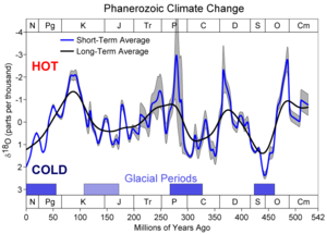
s for the past 800,000 years and marine sediment cores for the earlier period. Over the past 740,000 years there have been eight glacial cycles. The entire Quaternary Period (2.58 Ma) is referred to as an ice age
Ice age
An ice age or, more precisely, glacial age, is a generic geological period of long-term reduction in the temperature of the Earth's surface and atmosphere, resulting in the presence or expansion of continental ice sheets, polar ice sheets and alpine glaciers...
because at least one permanent large ice sheet — Antarctica — has existed continuously. There is uncertainty over how much of Greenland was covered by ice during the previous and earlier interglacials. During the colder episodes — referred to as glacial period
Glacial period
A glacial period is an interval of time within an ice age that is marked by colder temperatures and glacier advances. Interglacials, on the other hand, are periods of warmer climate within an ice age...
s — large ice sheets also existed in Europe
Europe
Europe is, by convention, one of the world's seven continents. Comprising the westernmost peninsula of Eurasia, Europe is generally 'divided' from Asia to its east by the watershed divides of the Ural and Caucasus Mountains, the Ural River, the Caspian and Black Seas, and the waterways connecting...
, North America
North America
North America is a continent wholly within the Northern Hemisphere and almost wholly within the Western Hemisphere. It is also considered a northern subcontinent of the Americas...
, and Siberia
Siberia
Siberia is an extensive region constituting almost all of Northern Asia. Comprising the central and eastern portion of the Russian Federation, it was part of the Soviet Union from its beginning, as its predecessor states, the Tsardom of Russia and the Russian Empire, conquered it during the 16th...
. The shorter and warmer intervals between glacials are referred to as interglacial
Interglacial
An Interglacial period is a geological interval of warmer global average temperature lasting thousands of years that separates consecutive glacial periods within an ice age...
s.
Currently, the earth is in an interglacial period, which marked the beginning of the Holocene
Holocene
The Holocene is a geological epoch which began at the end of the Pleistocene and continues to the present. The Holocene is part of the Quaternary period. Its name comes from the Greek words and , meaning "entirely recent"...
epoch. The current interglacial began between 10,000 and 15,000 years ago, which caused the ice sheets from the last glacial period to begin to disappear
Holocene glacial retreat
Holocene glacial retreat had a profound effect on landscapes in many areas that were covered by ice at the Last Glacial Maximum. The many valleys of the Cairngorms, a mountainous region in the Eastern Scottish Highlands are littered with deposits from this period.-Evidences of the retreat of the...
. Remnants of these last glaciers, now occupying about 10% of the world's land surface, still exist in Greenland and Antarctica. Global warming
Global warming
Global warming refers to the rising average temperature of Earth's atmosphere and oceans and its projected continuation. In the last 100 years, Earth's average surface temperature increased by about with about two thirds of the increase occurring over just the last three decades...
has exacerbated the retreat of these glaciers
Retreat of glaciers since 1850
The retreat of glaciers since 1850 affects the availability of fresh water for irrigation and domestic use, mountain recreation, animals and plants that depend on glacier-melt, and in the longer term, the level of the oceans...
.
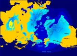
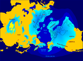
During the glacial periods, what we see as the normal (i.e. interglacial) hydrologic system was completely interrupted throughout large areas of the world and was considerably modified in others. Due to the volume of ice on land, sea level was approximately 120 meters lower than present. The evidence of such an event in the recent past is robust. Over the last century, extensive field observations have provided evidence that continental glaciers covered large parts of Europe
Europe
Europe is, by convention, one of the world's seven continents. Comprising the westernmost peninsula of Eurasia, Europe is generally 'divided' from Asia to its east by the watershed divides of the Ural and Caucasus Mountains, the Ural River, the Caspian and Black Seas, and the waterways connecting...
, North America
North America
North America is a continent wholly within the Northern Hemisphere and almost wholly within the Western Hemisphere. It is also considered a northern subcontinent of the Americas...
, and Siberia
Siberia
Siberia is an extensive region constituting almost all of Northern Asia. Comprising the central and eastern portion of the Russian Federation, it was part of the Soviet Union from its beginning, as its predecessor states, the Tsardom of Russia and the Russian Empire, conquered it during the 16th...
. Maps of glacial features were compiled after many years of fieldwork by hundreds of geologists who mapped the location and orientation of drumlin
Drumlin
A drumlin, from the Irish word droimnín , first recorded in 1833, is an elongated whale-shaped hill formed by glacial ice acting on underlying unconsolidated till or ground moraine.-Drumlin formation:...
s, esker
Esker
An esker is a long winding ridge of stratified sand and gravel, examples of which occur in glaciated and formerly glaciated regions of Europe and North America...
s, moraine
Moraine
A moraine is any glacially formed accumulation of unconsolidated glacial debris which can occur in currently glaciated and formerly glaciated regions, such as those areas acted upon by a past glacial maximum. This debris may have been plucked off a valley floor as a glacier advanced or it may have...
s, striations
Striation (geology)
In geology, a striation means linear furrows generated from fault movement; The striation's direction reveal the movement directions in the fault plane. Similar striations can occur with glaciation....
, and glacial stream channels. These maps revealed the extent of the ice sheet
Ice sheet
An ice sheet is a mass of glacier ice that covers surrounding terrain and is greater than 50,000 km² , thus also known as continental glacier...
s, the direction of flow, and the locations of systems of meltwater channels, and they allowed scientists to decipher a history of multiple advances and retreats of the ice. Even before the theory of worldwide glaciation was generally accepted, many observers recognized that more than a single advance and retreat of the ice had occurred. Extensive evidence now shows that a number of periods of growth and retreat of continental glaciers occurred during the ice age, called glacials and interglacial
Interglacial
An Interglacial period is a geological interval of warmer global average temperature lasting thousands of years that separates consecutive glacial periods within an ice age...
s. The interglacial periods of warm climate are represented by buried soil profiles, peat beds, and lake and stream deposits separating the unsorted, unstratified deposits of glacial debris.
Causes
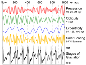
No completely satisfactory theory has been proposed to account for Earth's history of glaciation. The cause of glaciation may be related to several simultaneously occurring factors, such as astronomical cyclesOrbital forcing
Orbital forcing is the effect on climate of slow changes in the tilt of the Earth's axis and shape of the orbit . These orbital changes change the total amount of sunlight reaching the Earth by up to 25% at mid-latitudes...
, atmospheric composition, plate tectonics
Plate tectonics
Plate tectonics is a scientific theory that describes the large scale motions of Earth's lithosphere...
, and ocean current
Ocean current
An ocean current is a continuous, directed movement of ocean water generated by the forces acting upon this mean flow, such as breaking waves, wind, Coriolis effect, cabbeling, temperature and salinity differences and tides caused by the gravitational pull of the Moon and the Sun...
s.
Astronomical cycles
James Croll
James Croll was a 19th century Scottish scientist who developed a theory of climate change based on changes in the Earth's orbit.-Life:...
in the late 19th century. Later, Milutin Milanković
Milutin Milankovic
Milutin Milanković was a Serbian geophysicist and civil engineer, best known for his theory of ice ages, suggesting a relationship between Earth's long-term climate changes and periodic changes in its orbit, now known as Milankovitch cycles. Milanković gave two fundamental contributions to global...
, a Serbian geophysicist
Geophysics
Geophysics is the physics of the Earth and its environment in space; also the study of the Earth using quantitative physical methods. The term geophysics sometimes refers only to the geological applications: Earth's shape; its gravitational and magnetic fields; its internal structure and...
, elaborated on the theory and calculated these irregularities in Earth's orbit could cause the climatic cycles known as Milankovitch cycles
Milankovitch cycles
Milankovitch theory describes the collective effects of changes in the Earth's movements upon its climate, named after Serbian civil engineer and mathematician Milutin Milanković, who worked on it during First World War internment...
. They are the result of the additive behavior of several types of cyclical changes in Earth's orbital properties.
Changes in the orbital eccentricity
Orbital eccentricity
The orbital eccentricity of an astronomical body is the amount by which its orbit deviates from a perfect circle, where 0 is perfectly circular, and 1.0 is a parabola, and no longer a closed orbit...
of Earth occur on a cycle of about 100,000 years. The inclination
Inclination
Inclination in general is the angle between a reference plane and another plane or axis of direction.-Orbits:The inclination is one of the six orbital parameters describing the shape and orientation of a celestial orbit...
, or tilt, of Earth's axis varies periodically between 22° and 24.5°. (The tilt of Earth's axis is responsible for the season
Season
A season is a division of the year, marked by changes in weather, ecology, and hours of daylight.Seasons result from the yearly revolution of the Earth around the Sun and the tilt of the Earth's axis relative to the plane of revolution...
s; the greater the tilt, the greater the contrast between summer and winter temperatures.) Changes in the tilt occur in a cycle 41,000 years long. Precession of the equinoxes, or wobbles on Earth's spin axis, complete every 21,700 years. According to the Milankovitch theory, these factors cause a periodic cooling of Earth, with the coldest part in the cycle occurring about every 40,000 years. The main effect of the Milankovitch cycles is to change the contrast between the seasons, not the amount of solar heat Earth receives. These cycles within cycles predict that during maximum glacial advances, winter and summer temperatures are lower. The result is less ice melting than accumulating, and glacier
Glacier
A glacier is a large persistent body of ice that forms where the accumulation of snow exceeds its ablation over many years, often centuries. At least 0.1 km² in area and 50 m thick, but often much larger, a glacier slowly deforms and flows due to stresses induced by its weight...
s build up.
Milankovitch worked out the ideas of climatic cycles in the 1920s and 1930s, but it was not until the 1970s that sufficiently long and detailed chronology of the Quaternary temperature changes was worked out to test the theory adequately. Studies of deep-sea cores, and the fossils contained in them indicate that the fluctuation of climate during the last few hundred thousand years is remarkably close to that predicted by Milankovitch.
A problem with the theory is that the astronomical cycles have been in existence for billions of years, but glaciation is a rare occurrence. Actually, astronomical cycles perfectly explain glacial and interglacial periods, and their transitions, inside an ice age. Other factors must also be involved that caused Earth's temperature to drop below a critical threshold. Once that occurs, Milankovitch cycles will act to force the planet in and out of glacial period
Glacial period
A glacial period is an interval of time within an ice age that is marked by colder temperatures and glacier advances. Interglacials, on the other hand, are periods of warmer climate within an ice age...
s.
Atmospheric composition
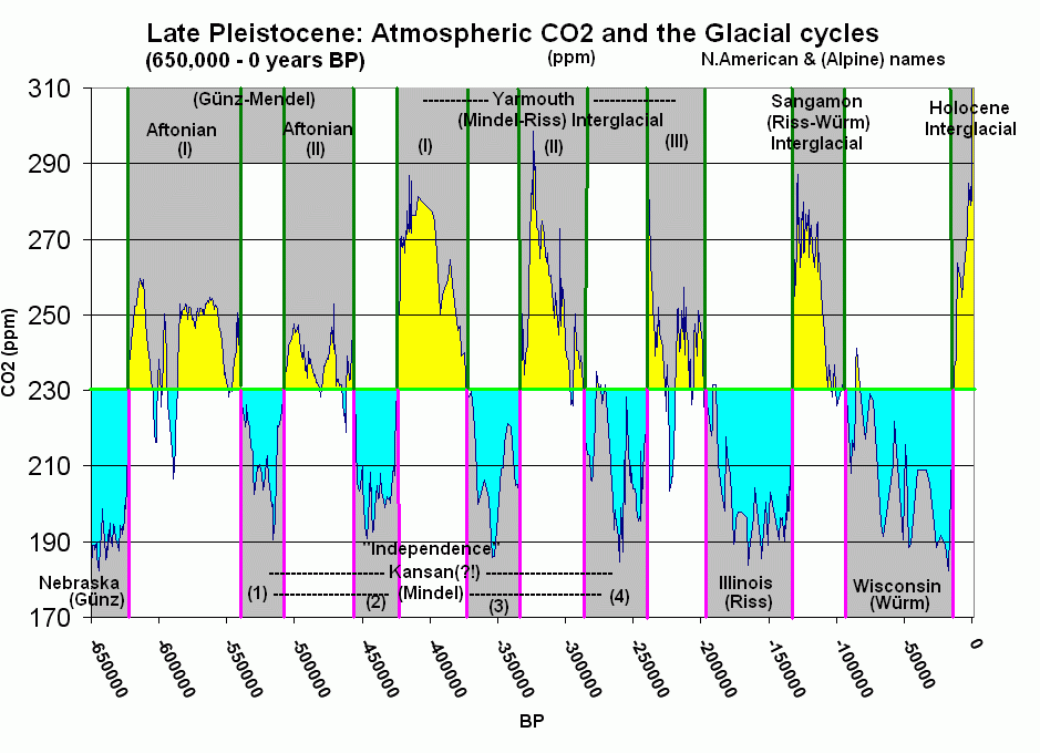
Carbon dioxide
Carbon dioxide is a naturally occurring chemical compound composed of two oxygen atoms covalently bonded to a single carbon atom...
(CO2), an important greenhouse gas
Greenhouse gas
A greenhouse gas is a gas in an atmosphere that absorbs and emits radiation within the thermal infrared range. This process is the fundamental cause of the greenhouse effect. The primary greenhouse gases in the Earth's atmosphere are water vapor, carbon dioxide, methane, nitrous oxide, and ozone...
, started the long-term cooling trend that eventually led to glaciation. Recent studies of the CO2 content of gas bubbles preserved in the Greenland ice core
Ice core
An ice core is a core sample that is typically removed from an ice sheet, most commonly from the polar ice caps of Antarctica, Greenland or from high mountain glaciers elsewhere. As the ice forms from the incremental build up of annual layers of snow, lower layers are older than upper, and an ice...
s lend support to this idea. The geochemical
Geochemistry
The field of geochemistry involves study of the chemical composition of the Earth and other planets, chemical processes and reactions that govern the composition of rocks, water, and soils, and the cycles of matter and energy that transport the Earth's chemical components in time and space, and...
cycle of carbon indicates more than a 10-fold decrease in atmospheric CO2 since the middle of the Mesozoic
Mesozoic
The Mesozoic era is an interval of geological time from about 250 million years ago to about 65 million years ago. It is often referred to as the age of reptiles because reptiles, namely dinosaurs, were the dominant terrestrial and marine vertebrates of the time...
Era. However, it is unclear what caused the decline in CO2 levels, and whether this decline is the cause of global cooling or if it is the result.
CO2 levels also play an important role in the transitions between interglacials and glacials. High CO2 contents correspond to warm interglacial periods, and low CO2 to glacial periods. However, studies indicate that CO2 may not be the primary cause of the interglacial-glacial transitions, but instead acts as a feedback
Feedback
Feedback describes the situation when output from an event or phenomenon in the past will influence an occurrence or occurrences of the same Feedback describes the situation when output from (or information about the result of) an event or phenomenon in the past will influence an occurrence or...
. The explanation for this observed CO2 variation "remains a difficult attribution problem."
Plate tectonics and ocean currents
An important component in the long-term temperature drop may be related to the positions of the continents, relative to the poles (but it cannot explain the rapid retreat and advances of glaciers). This relation can control the circulation of the oceans and the atmosphere, affecting how ocean currents carry heat to high latitude. Throughout most of the geologic timeGeologic time scale
The geologic time scale provides a system of chronologic measurement relating stratigraphy to time that is used by geologists, paleontologists and other earth scientists to describe the timing and relationships between events that have occurred during the history of the Earth...
, the North Pole
North Pole
The North Pole, also known as the Geographic North Pole or Terrestrial North Pole, is, subject to the caveats explained below, defined as the point in the northern hemisphere where the Earth's axis of rotation meets its surface...
appears to have been in a broad, open ocean that allowed major ocean currents to move unabated. Equatorial waters flowed into the polar regions, warming them with water from the more temperate latitudes. This unrestricted circulation produced mild, uniform climates that persisted throughout most of geologic time.
Throughout the Cenozoic
Cenozoic
The Cenozoic era is the current and most recent of the three Phanerozoic geological eras and covers the period from 65.5 mya to the present. The era began in the wake of the Cretaceous–Tertiary extinction event at the end of the Cretaceous that saw the demise of the last non-avian dinosaurs and...
Era, the large North America
North America
North America is a continent wholly within the Northern Hemisphere and almost wholly within the Western Hemisphere. It is also considered a northern subcontinent of the Americas...
n and South America
South America
South America is a continent situated in the Western Hemisphere, mostly in the Southern Hemisphere, with a relatively small portion in the Northern Hemisphere. The continent is also considered a subcontinent of the Americas. It is bordered on the west by the Pacific Ocean and on the north and east...
n continental plates moved westward from the Eurasia
Eurasia
Eurasia is a continent or supercontinent comprising the traditional continents of Europe and Asia ; covering about 52,990,000 km2 or about 10.6% of the Earth's surface located primarily in the eastern and northern hemispheres...
n plate. This drift culminated in the development of the Atlantic Ocean
Atlantic Ocean
The Atlantic Ocean is the second-largest of the world's oceanic divisions. With a total area of about , it covers approximately 20% of the Earth's surface and about 26% of its water surface area...
, trending north-south, with the North Pole in the small, nearly landlocked basin of the Arctic Ocean
Arctic Ocean
The Arctic Ocean, located in the Northern Hemisphere and mostly in the Arctic north polar region, is the smallest and shallowest of the world's five major oceanic divisions...
. The Isthmus of Panama
Isthmus of Panama
The Isthmus of Panama, also historically known as the Isthmus of Darien, is the narrow strip of land that lies between the Caribbean Sea and the Pacific Ocean, linking North and South America. It contains the country of Panama and the Panama Canal...
developed at a convergent plate margin about 3 million years ago, and further separated oceanic circulation and created the Pacific
Pacific Ocean
The Pacific Ocean is the largest of the Earth's oceanic divisions. It extends from the Arctic in the north to the Southern Ocean in the south, bounded by Asia and Australia in the west, and the Americas in the east.At 165.2 million square kilometres in area, this largest division of the World...
and Atlantic oceans.
Effects
The presence of so much ice upon the continents had a profound effect upon almost every aspect of Earth's hydrologic system. The most obvious effects are the spectacular mountain scenery and other continental landscapes fashioned both by glacial erosion and deposition instead of running water. Entirely new landscapes covering millions of square kilometers were formed in a relatively short period of geologic time. In addition, the vast bodies of glacial ice affected the Earth well beyond the glacier margins. Directly or indirectly, the effects of glaciation were felt in every part of the world.Lakes
The Quaternary glaciation created more lakes than all other geologic processes combined. The reason is that a continental glacierGlacier
A glacier is a large persistent body of ice that forms where the accumulation of snow exceeds its ablation over many years, often centuries. At least 0.1 km² in area and 50 m thick, but often much larger, a glacier slowly deforms and flows due to stresses induced by its weight...
completely disrupts the preglacial drainage system
Drainage system (Geomorphology)
In geomorphology, a drainage system is the pattern formed by the streams, rivers, and lakes in a particular drainage basin. They are governed by the topography of the land, whether a particular region is dominated by hard or soft rocks, and the gradient of the land. Geomorphologists and...
. The surface over which the glacier moved was scoured and eroded
Erosion
Erosion is when materials are removed from the surface and changed into something else. It only works by hydraulic actions and transport of solids in the natural environment, and leads to the deposition of these materials elsewhere...
by the ice, leaving myriad closed, undrained depressions in the bedrock. These depressions filled with water and became lake
Lake
A lake is a body of relatively still fresh or salt water of considerable size, localized in a basin, that is surrounded by land. Lakes are inland and not part of the ocean and therefore are distinct from lagoons, and are larger and deeper than ponds. Lakes can be contrasted with rivers or streams,...
s.
Very large lakes were created along the glacial margins. The ice on both North America
North America
North America is a continent wholly within the Northern Hemisphere and almost wholly within the Western Hemisphere. It is also considered a northern subcontinent of the Americas...
and Europe
Europe
Europe is, by convention, one of the world's seven continents. Comprising the westernmost peninsula of Eurasia, Europe is generally 'divided' from Asia to its east by the watershed divides of the Ural and Caucasus Mountains, the Ural River, the Caspian and Black Seas, and the waterways connecting...
was about 3,000 m (10,000 ft) thick near the centers of maximum accumulation, but it tapered toward the glacier margins. Crustal subsidence was greatest beneath the thickest accumulation of ice. As the ice melted, rebound of the crust lagged behind, producing a regional slope toward the ice. This slope formed basins that have lasted for thousands of years. These basins became lakes or were invaded by the ocean. The Great Lakes
Great Lakes
The Great Lakes are a collection of freshwater lakes located in northeastern North America, on the Canada – United States border. Consisting of Lakes Superior, Michigan, Huron, Erie, and Ontario, they form the largest group of freshwater lakes on Earth by total surface, coming in second by volume...
and the Baltic Sea
Baltic Sea
The Baltic Sea is a brackish mediterranean sea located in Northern Europe, from 53°N to 66°N latitude and from 20°E to 26°E longitude. It is bounded by the Scandinavian Peninsula, the mainland of Europe, and the Danish islands. It drains into the Kattegat by way of the Øresund, the Great Belt and...
of northern Europe were formed primarily in this way.
Pluvial lakes
The climatic conditions that cause glaciation had an indirect effect on arid and semiarid regions far removed from the large ice sheetIce sheet
An ice sheet is a mass of glacier ice that covers surrounding terrain and is greater than 50,000 km² , thus also known as continental glacier...
s. The increased precipitation that fed the glacier
Glacier
A glacier is a large persistent body of ice that forms where the accumulation of snow exceeds its ablation over many years, often centuries. At least 0.1 km² in area and 50 m thick, but often much larger, a glacier slowly deforms and flows due to stresses induced by its weight...
s also increased the runoff of major rivers and intermittent streams, resulting in the growth and development of large pluvial lake
Pluvial lake
A pluvial lake is a landlocked basin which fills with rainwater during times of glaciation, when precipitation is higher. Pluvial lakes that have since evaporated and dried out may also be referred to as paleolakes.-Geology:...
s. Most pluvial lakes developed in relatively arid regions where there typically was insufficient rain to establish a drainage system to the sea. Instead, stream runoff in those areas flowed into closed basins and formed playa lakes. With increased rainfall, the playa lakes enlarged and overflowed. Pluvial lakes were most extensive during glacial periods. During interglacial stages, when less precipitation fell, the pluvial lakes shrank to form small salt flats.
Isostatic adjustment
Major isostatic adjustments of the lithosphereLithosphere
The lithosphere is the rigid outermost shell of a rocky planet. On Earth, it comprises the crust and the portion of the upper mantle that behaves elastically on time scales of thousands of years or greater.- Earth's lithosphere :...
during the Quaternary glaciation were caused by the weight of the ice, which depressed the continents. In Canada
Canada
Canada is a North American country consisting of ten provinces and three territories. Located in the northern part of the continent, it extends from the Atlantic Ocean in the east to the Pacific Ocean in the west, and northward into the Arctic Ocean...
, a large area around Hudson Bay
Hudson Bay
Hudson Bay , sometimes called Hudson's Bay, is a large body of saltwater in northeastern Canada. It drains a very large area, about , that includes parts of Ontario, Quebec, Saskatchewan, Alberta, most of Manitoba, southeastern Nunavut, as well as parts of North Dakota, South Dakota, Minnesota,...
was depressed below sea level, as was the area in Europe around the Baltic Sea. The land has been rebounding from these depressions since the ice melted. Some of these isostatic movements triggered large earthquake
Earthquake
An earthquake is the result of a sudden release of energy in the Earth's crust that creates seismic waves. The seismicity, seismism or seismic activity of an area refers to the frequency, type and size of earthquakes experienced over a period of time...
s in Scandinavia about 9,000 years ago. These earthquakes are unique in that they are not associated with plate tectonics
Plate tectonics
Plate tectonics is a scientific theory that describes the large scale motions of Earth's lithosphere...
.
Studies have shown that the uplift has taken place in two distinct stages. The initial uplift following deglaciation was rapid (called "elastic"), and took place as the ice was being unloaded. After this "elastic" phase, uplift proceed by "slow viscous flow" so the rate decreased exponentially after that. Today, typical uplift rates are of the order of 1 cm per year or less. In northern Europe, this is clearly shown by the GPS data obtained by the BIFROST GPS network. Studies suggest that rebound will continue for about at least another 10,000 years. The total uplift from the end of deglaciation depends on the local ice load and could be several hundred meters near the center of rebound.
Winds
The presence of ice over so much of the continents greatly modified patterns of atmospheric circulation. Winds near the glacial margins were strong and persistent because of the abundance of dense, cold air coming off the glacier fields. These winds picked up and transported large quantities of loose, fine-grained sediment brought down by the glaciers. This dust accumulated as loessLoess
Loess is an aeolian sediment formed by the accumulation of wind-blown silt, typically in the 20–50 micrometre size range, twenty percent or less clay and the balance equal parts sand and silt that are loosely cemented by calcium carbonate...
(wind-blown silt), forming irregular blankets over much of the Missouri River
Missouri River
The Missouri River flows through the central United States, and is a tributary of the Mississippi River. It is the longest river in North America and drains the third largest area, though only the thirteenth largest by discharge. The Missouri's watershed encompasses most of the American Great...
valley, central Europe, and northern China
China
Chinese civilization may refer to:* China for more general discussion of the country.* Chinese culture* Greater China, the transnational community of ethnic Chinese.* History of China* Sinosphere, the area historically affected by Chinese culture...
.
Sand dune
Dune
In physical geography, a dune is a hill of sand built by wind. Dunes occur in different forms and sizes, formed by interaction with the wind. Most kinds of dunes are longer on the windward side where the sand is pushed up the dune and have a shorter "slip face" in the lee of the wind...
s were much more widespread and active in many areas during the early Quaternary period. A good example is the Sand Hills
Sand Hills (Nebraska)
The Sand Hills, often written Sandhills, is a region of mixed-grass prairie on grass-stabilized sand dunes in north-central Nebraska, covering just over one quarter of the state...
region in Nebraska
Nebraska
Nebraska is a state on the Great Plains of the Midwestern United States. The state's capital is Lincoln and its largest city is Omaha, on the Missouri River....
, USA, which covers an area of about 60000 square kilometres (23,166 sq mi). This region was a large, active dune field during the Pleistocene
Pleistocene
The Pleistocene is the epoch from 2,588,000 to 11,700 years BP that spans the world's recent period of repeated glaciations. The name pleistocene is derived from the Greek and ....
epoch, but today is largely stabilized by grass cover.
Records of prior glaciation
Paleozoic
The Paleozoic era is the earliest of three geologic eras of the Phanerozoic eon, spanning from roughly...
Era (200 to 300 Ma) and during late Precambrian (i.e. in the Neoproterozoic
Neoproterozoic
The Neoproterozoic Era is the unit of geologic time from 1,000 to 542.0 ± 1.0 million years ago. The terminal Era of the formal Proterozoic Eon , it is further subdivided into the Tonian, Cryogenian, and Ediacaran Periods...
Era, 600 to 800 Ma). Before the current ice age
Ice age
An ice age or, more precisely, glacial age, is a generic geological period of long-term reduction in the temperature of the Earth's surface and atmosphere, resulting in the presence or expansion of continental ice sheets, polar ice sheets and alpine glaciers...
, which began 2 to 3 Ma, Earth's climate was typically mild and uniform for long periods of time. This climatic history is implied by the types of fossil
Fossil
Fossils are the preserved remains or traces of animals , plants, and other organisms from the remote past...
plants and animals and by the characteristics of sediments preserved in the stratigraphic
Stratum
In geology and related fields, a stratum is a layer of sedimentary rock or soil with internally consistent characteristics that distinguish it from other layers...
record. There are, however, widespread glacial deposits, recording several major periods of ancient glaciation in various parts of the geologic record. Such evidence suggests major periods of glaciation prior to the current Quaternary glaciation.
The best documented record of pre-Quaternary glaciation, called the Karoo Ice Age
Karoo Ice Age
The Karoo Ice Age from 360–260 Ma was the second major ice age of the Phanerozoic Eon. It is named after the glacial tills found in the Karoo region of South Africa where evidence for this ice age was first clearly identified....
, is found in the late Paleozoic rocks in South Africa
South Africa
The Republic of South Africa is a country in southern Africa. Located at the southern tip of Africa, it is divided into nine provinces, with of coastline on the Atlantic and Indian oceans...
, India
India
India , officially the Republic of India , is a country in South Asia. It is the seventh-largest country by geographical area, the second-most populous country with over 1.2 billion people, and the most populous democracy in the world...
, South America
South America
South America is a continent situated in the Western Hemisphere, mostly in the Southern Hemisphere, with a relatively small portion in the Northern Hemisphere. The continent is also considered a subcontinent of the Americas. It is bordered on the west by the Pacific Ocean and on the north and east...
, Antarctica, and Australia
Australia
Australia , officially the Commonwealth of Australia, is a country in the Southern Hemisphere comprising the mainland of the Australian continent, the island of Tasmania, and numerous smaller islands in the Indian and Pacific Oceans. It is the world's sixth-largest country by total area...
. Exposures of ancient glacial deposits are numerous in these areas. Deposits of even older glacial sediment exist on every continent except South America. These indicate that two other periods of widespread glaciation occurred during late the Precambrian, producing the Snowball Earth
Snowball Earth
The Snowball Earth hypothesis posits that the Earth's surface became entirely or nearly entirely frozen at least once, some time earlier than 650 Ma . Proponents of the hypothesis argue that it best explains sedimentary deposits generally regarded as of glacial origin at tropical...
during the Cryogenian
Cryogenian
The Cryogenian is a geologic period that lasted from . It forms the second geologic period of the Neoproterozoic Era, preceded by the Tonian Period and followed by the Ediacaran...
Period.
Next glacial period
Glacial period
A glacial period is an interval of time within an ice age that is marked by colder temperatures and glacier advances. Interglacials, on the other hand, are periods of warmer climate within an ice age...
(because the earth is currently in an interglacial
Interglacial
An Interglacial period is a geological interval of warmer global average temperature lasting thousands of years that separates consecutive glacial periods within an ice age...
period).
The next glacial seemed rapidly approaching, when paleoclimatologists
Paleoclimatology
Paleoclimatology is the study of changes in climate taken on the scale of the entire history of Earth. It uses a variety of proxy methods from the Earth and life sciences to obtain data previously preserved within rocks, sediments, ice sheets, tree rings, corals, shells and microfossils; it then...
met in 1972 to discuss this issue (a period of so-called global cooling
Global cooling
Global cooling was a conjecture during the 1970s of imminent cooling of the Earth's surface and atmosphere along with a posited commencement of glaciation...
). The previous interglacial periods seemed to have lasted about 10,000 years each. Assuming that the present interglacial period would be just as long, they concluded, "it is likely that the present-day warm epoch will terminate relatively soon if man does not intervene." Since 1972, our understanding of the climate system has improved. It is known that not all interglacial periods are of the same length and that solar heating varies in a non-linear fashion forced by the Milankovitch orbital cycles
Milankovitch cycles
Milankovitch theory describes the collective effects of changes in the Earth's movements upon its climate, named after Serbian civil engineer and mathematician Milutin Milanković, who worked on it during First World War internment...
(see Causes section above). At the same time, it is also known that greenhouse gas
Greenhouse gas
A greenhouse gas is a gas in an atmosphere that absorbs and emits radiation within the thermal infrared range. This process is the fundamental cause of the greenhouse effect. The primary greenhouse gases in the Earth's atmosphere are water vapor, carbon dioxide, methane, nitrous oxide, and ozone...
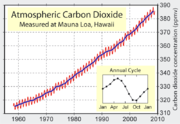
es are increasing in concentration with each passing year. Based on the variations in solar heating and on the amount of CO2 in the atmosphere, some calculations of future temperatures have been made. According to these estimates, the interglacial period the earth is in now may persist for another 50,000 years if CO2 levels increase to 750 parts per million (ppm
Parts-per notation
In science and engineering, the parts-per notation is a set of pseudo units to describe small values of miscellaneous dimensionless quantities, e.g. mole fraction or mass fraction. Since these fractions are quantity-per-quantity measures, they are pure numbers with no associated units of measurement...
) (the present atmospheric concentration of CO2 is about 385 ppm by volume, but is rising rapidly
Global warming
Global warming refers to the rising average temperature of Earth's atmosphere and oceans and its projected continuation. In the last 100 years, Earth's average surface temperature increased by about with about two thirds of the increase occurring over just the last three decades...
as humans continue to burn fossil fuel
Fossil fuel
Fossil fuels are fuels formed by natural processes such as anaerobic decomposition of buried dead organisms. The age of the organisms and their resulting fossil fuels is typically millions of years, and sometimes exceeds 650 million years...
s.) If CO2 drops instead to 210 ppm, then the next glacial period may only be 15,000 years away.
Moreover, studies of seafloor sediments and ice core
Ice core
An ice core is a core sample that is typically removed from an ice sheet, most commonly from the polar ice caps of Antarctica, Greenland or from high mountain glaciers elsewhere. As the ice forms from the incremental build up of annual layers of snow, lower layers are older than upper, and an ice...
s from glaciers around the world, namely Greenland
Greenland
Greenland is an autonomous country within the Kingdom of Denmark, located between the Arctic and Atlantic Oceans, east of the Canadian Arctic Archipelago. Though physiographically a part of the continent of North America, Greenland has been politically and culturally associated with Europe for...
, indicate that climatic change is not smooth. Studies of isotopic composition of the ice cores indicate the change from warm to frigid temperatures can occur in a decade or two. In addition, the ice cores show that an ice age is not uniformly cold, nor are interglacial periods uniformly warm (see also stadial
Stadial
A stadial is a period of lower temperatures during an interglacial separating the glacial periods of an ice age. Such periods are of insufficient duration or intensity to be considered glacial periods...
). Analysis of ice cores of the entire thickness of the Greenland glacier shows that climate over the last 250,000 years has changed frequently and abruptly. The present interglacial period (the last 10,000 to 15,000 years) has been fairly stable and warm, but the previous one was interrupted by numerous frigid spells lasting hundreds of years. If the previous period was more typical than the present one, the period of stable climate in which humans flourished—inventing agriculture
Agriculture
Agriculture is the cultivation of animals, plants, fungi and other life forms for food, fiber, and other products used to sustain life. Agriculture was the key implement in the rise of sedentary human civilization, whereby farming of domesticated species created food surpluses that nurtured the...
and thus civilization
Civilization
Civilization is a sometimes controversial term that has been used in several related ways. Primarily, the term has been used to refer to the material and instrumental side of human cultures that are complex in terms of technology, science, and division of labor. Such civilizations are generally...
—may have been possible only because of a highly unusual period of stable temperature.
External links
- Glaciers and Glaciation
- Pleistocene Glaciation and Diversion of the Missouri River in Northern Montana
- Correlation of late Pleistocene glaciation in the western United States with North Atlantic Heinrich events
- After the Ice Age: The Return of Life to Glaciated North America by E.C. Pielou
- Alaska's Glacier and Icefields
- Pleistocene glaciations(the last 2 millions years)
- IPCC's Palaeoclimate(pdf)
Causes