

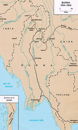
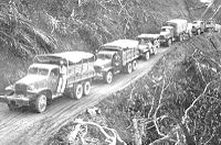
Ledo Road
Encyclopedia
Assam
Assam , also, rarely, Assam Valley and formerly the Assam Province , is a northeastern state of India and is one of the most culturally and geographically distinct regions of the country...
, India
India
India , officially the Republic of India , is a country in South Asia. It is the seventh-largest country by geographical area, the second-most populous country with over 1.2 billion people, and the most populous democracy in the world...
to Kunming
Kunming
' is the capital and largest city of Yunnan Province in Southwest China. It was known as Yunnan-Fou until the 1920s. A prefecture-level city, it is the political, economic, communications and cultural centre of Yunnan, and is the seat of the provincial government...
, Yunnan
Yunnan
Yunnan is a province of the People's Republic of China, located in the far southwest of the country spanning approximately and with a population of 45.7 million . The capital of the province is Kunming. The province borders Burma, Laos, and Vietnam.Yunnan is situated in a mountainous area, with...
, China
China
Chinese civilization may refer to:* China for more general discussion of the country.* Chinese culture* Greater China, the transnational community of ethnic Chinese.* History of China* Sinosphere, the area historically affected by Chinese culture...
) was built during World War II
World War II
World War II, or the Second World War , was a global conflict lasting from 1939 to 1945, involving most of the world's nations—including all of the great powers—eventually forming two opposing military alliances: the Allies and the Axis...
so that the Western Allies
Western Allies
The Western Allies were a political and geographic grouping among the Allied Powers of the Second World War. It generally includes the United Kingdom and British Commonwealth, the United States, France and various other European and Latin American countries, but excludes China, the Soviet Union,...
could supply the Chinese
China
Chinese civilization may refer to:* China for more general discussion of the country.* Chinese culture* Greater China, the transnational community of ethnic Chinese.* History of China* Sinosphere, the area historically affected by Chinese culture...
as an alternative to the Burma Road
Burma Road
The Burma Road is a road linking Burma with the southwest of China. Its terminals are Kunming, Yunnan, and Lashio, Burma. When it was built, Burma was a British colony.The road is long and runs through rough mountain country...
which had been cut by the Japan
Japan
Japan is an island nation in East Asia. Located in the Pacific Ocean, it lies to the east of the Sea of Japan, China, North Korea, South Korea and Russia, stretching from the Sea of Okhotsk in the north to the East China Sea and Taiwan in the south...
ese in 1942. It was renamed the Stilwell Road (named after General Vinegar Joe Stilwell
Joseph Stilwell
General Joseph Warren Stilwell was a United States Army four-star General known for service in the China Burma India Theater. His caustic personality was reflected in the nickname "Vinegar Joe"...
of the U.S. Army) in early 1945 at the suggestion of Chiang Kai-shek
Chiang Kai-shek
Chiang Kai-shek was a political and military leader of 20th century China. He is known as Jiǎng Jièshí or Jiǎng Zhōngzhèng in Mandarin....
. It passes through Burma towns of shingbwiyang, Myitkyina
Myitkyina
Myitkyina is the capital city of Kachin State in Myanmar , located from Yangon, and from Mandalay. In Burmese it means "near the big river", and in fact "Myitkyina" lies on the west bank of the Ayeyarwady River, just below from Myit-son of its two headstreams...
and Bhamo
Bhamo
Bhamo is a city of Kachin State in northernmost part of Myanmar, located 186 km south from the capital city of Myitkyina. It is on the Ayeyarwady River. It lies within 65 km of the border with Yunnan Province, China. The population consists of Chinese and Shan, with Kachin peoples in...
in Kachin state
Kachin State
Kachin State , is the northernmost state of Burma. It is bordered by China to the north and east; Shan State to the south; and Sagaing Division and India to the west. It lies between north latitude 23° 27' and 28° 25' longitude 96° 0' and 98° 44'. The area of Kachin State is . The capital of the...
.
In the nineteenth century British
United Kingdom
The United Kingdom of Great Britain and Northern IrelandIn the United Kingdom and Dependencies, other languages have been officially recognised as legitimate autochthonous languages under the European Charter for Regional or Minority Languages...
railway builders had surveyed the Pangsau Pass
Pangsau pass
Pangsau Pass, in altitude, lies on the crest of the Patkai Hills on the India-Burma border. The reputed route of the 13th century invasion of Assam in India by the Ahoms, a Shan tribe, the pass offers one of the easiest routes into Burma from the Assam plains...
, which is 3,727 feet (1,136 m) high on the India-Burma border, on the Patkai
Patkai
The Pat-kai meaning to Cut Chicken in Tai Ahom language are the hills on India's North Eastern border with Burma. They were created by the same tectonic processes that resulted in the formation of the Himalayain the Mesozoic . They are not as rugged as the Himalayas and its peaks are much lower...
crest, above Nampong, Arunachal Pradesh
Arunachal Pradesh
Arunachal Pradesh is a state of India, located in the far northeast. It borders the states of Assam and Nagaland to the south, and shares international borders with Burma in the east, Bhutan in the west, and the People's Republic of China in the north. The majority of the territory is claimed by...
(then part of Assam
Assam
Assam , also, rarely, Assam Valley and formerly the Assam Province , is a northeastern state of India and is one of the most culturally and geographically distinct regions of the country...
). They concluded that a track could be pushed through to Burma and down the Hukawng Valley
Hukawng Valley
The Hukawng Valley is an isolated valley in Burma, roughly in area. It is located in Tanaing Township in the Myitkyina District of Kachin State in the northernmost part of the country.-Rivers:...
. Although the proposal was dropped, the British prospected the Patkai
Patkai
The Pat-kai meaning to Cut Chicken in Tai Ahom language are the hills on India's North Eastern border with Burma. They were created by the same tectonic processes that resulted in the formation of the Himalayain the Mesozoic . They are not as rugged as the Himalayas and its peaks are much lower...
Range for a road from Assam into northern Burma. British engineers had surveyed the route for a road for the first eighty miles. After the British had been pushed back out of most of Burma by the Japanese, building this road became a priority for the United States. After Rangoon
Yangon
Yangon is a former capital of Burma and the capital of Yangon Region . Although the military government has officially relocated the capital to Naypyidaw since March 2006, Yangon, with a population of over four million, continues to be the country's largest city and the most important commercial...
was captured by the Japanese
Japanese people
The are an ethnic group originating in the Japanese archipelago and are the predominant ethnic group of Japan. Worldwide, approximately 130 million people are of Japanese descent; of these, approximately 127 million are residents of Japan. People of Japanese ancestry who live in other countries...
and before the Ledo Road was finished, the majority of supplies to the Chinese were delivered via airlift over the eastern end of the Himalayan Mountains known as the Hump
The Hump
The Hump was the name given by Allied pilots in the Second World War to the eastern end of the Himalayan Mountains over which they flew military transport aircraft from India to China to resupply the Chinese war effort of Chiang Kai-shek and the units of the United States Army Air Forces based in...
.
Construction
On December 1, 1942, British GeneralGeneral
A general officer is an officer of high military rank, usually in the army, and in some nations, the air force. The term is widely used by many nations of the world, and when a country uses a different term, there is an equivalent title given....
Sir Archibald Wavell, the supreme commander of the Far Eastern Theatre, agreed with American General Stilwell
Joseph Stilwell
General Joseph Warren Stilwell was a United States Army four-star General known for service in the China Burma India Theater. His caustic personality was reflected in the nickname "Vinegar Joe"...
to make the Ledo Road an American
United States
The United States of America is a federal constitutional republic comprising fifty states and a federal district...
NCAC
Northern Combat Area Command
The Northern Combat Area Command or NCAC was a mainly Sino-American formation that held the northern end of the Allied front in Burma during World War II. For much of its existence it was commanded by the acerbic General Joseph "Vinegar Joe" Stilwell, and controlled by his staff...
operation. The Ledo Road was intended to be the primary supply route to China and was built under the direction of General Stilwell from the railhead at Ledo (Assam, India
India
India , officially the Republic of India , is a country in South Asia. It is the seventh-largest country by geographical area, the second-most populous country with over 1.2 billion people, and the most populous democracy in the world...
) to Mong-Yu
Mong-Yu
Located near Wanting in southwestern China, Mong-yu is where the Ledo Road joined the Burma Road....
road junction where it joined the Burma Road
Burma Road
The Burma Road is a road linking Burma with the southwest of China. Its terminals are Kunming, Yunnan, and Lashio, Burma. When it was built, Burma was a British colony.The road is long and runs through rough mountain country...
. From there trucks could continue on to Wanting on the Chinese frontier, so that supplies could be delivered to the reception point in Kunming
Kunming
' is the capital and largest city of Yunnan Province in Southwest China. It was known as Yunnan-Fou until the 1920s. A prefecture-level city, it is the political, economic, communications and cultural centre of Yunnan, and is the seat of the provincial government...
, China. Stilwell's staff estimated that the Ledo Road route would supply 65,000 tons of supplies per month, greatly surpassing tonnage then being airlifted over the Hump
The Hump
The Hump was the name given by Allied pilots in the Second World War to the eastern end of the Himalayan Mountains over which they flew military transport aircraft from India to China to resupply the Chinese war effort of Chiang Kai-shek and the units of the United States Army Air Forces based in...
to China. General Claire Lee Chennault
Claire Lee Chennault
Lieutenant General Claire Lee Chennault , was an American military aviator. A contentious officer, he was a fierce advocate of "pursuit" or fight-interceptor aircraft during the 1930s when the U.S. Army Air Corps was focused primarily on high-altitude bombardment...
, the USAAF Fourteenth Air Force
Fourteenth Air Force
The Fourteenth Air Force is a numbered air force of the United States Air Force Space Command . It is headquartered at Vandenberg Air Force Base, California....
commander, thought the projected tonnage levels were overly optimistic and doubted that such an extended network of trails through difficult jungle could ever match the amount of supplies that could be delivered with modern cargo transport aircraft.
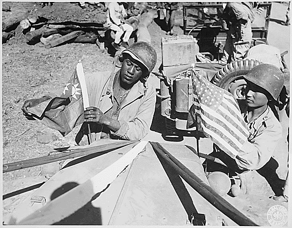
The road was built by 15,000 American soldiers (60 percent of whom were African-Americans) and 35,000 local workers at a cost of US$150 million. 1,100 Americans died during the construction, as well as many more locals. As most of Burma was in Japanese hands it was not possible to acquire information as to the topography
Topography
Topography is the study of Earth's surface shape and features or those ofplanets, moons, and asteroids...
, soil
Soil
Soil is a natural body consisting of layers of mineral constituents of variable thicknesses, which differ from the parent materials in their morphological, physical, chemical, and mineralogical characteristics...
s, and river
River
A river is a natural watercourse, usually freshwater, flowing towards an ocean, a lake, a sea, or another river. In a few cases, a river simply flows into the ground or dries up completely before reaching another body of water. Small rivers may also be called by several other names, including...
behaviour before construction started. This information had to be acquired as the road was constructed.
General Stilwell had organized a 'Service of Supply' (SOS) under the command of Major General Raymond A. Wheeler
Raymond Albert Wheeler
Raymond Albert Wheeler was a Lieutenant General in the United States Army. He graduated from the United States Military Academy in 1911....
, a high profile US Army engineer and assigned him to look after the construction of the Ledo Road. Major General Wheeler, in turn, assigned responsibility of base commander for the road construction to Colonel John C. Arrowsmith
John C. Arrowsmith
John Caraway Arrowsmith was a Colonel in the United States Army Corps of Engineers, commanding the 45th Engineers in the China-Burma-India Theater of Operations during World War II....
. Later, he was replaced by Colonel Lewis A. Pick
Lewis A. Pick
Lewis Andrew Pick was born in Brookneal, Virginia, and graduated from Virginia Polytechnic Institute in 1914. He received his Regular Army commission in the United States Army Corps of Engineers on July 1, 1920....
, an expert US Army engineer.
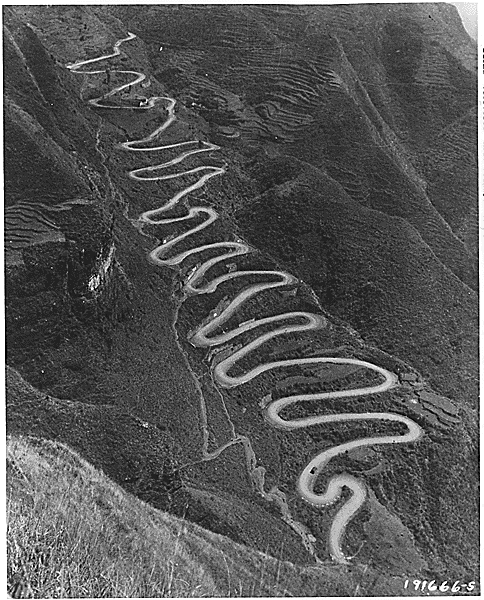
Work started on the first 103 mile (166 km) section of the road in December 1942, followed a steep, narrow trail through territory from Ledo, across the Patkai Range through the Pangsau Pass, nicknamed "Hell Pass
Pangsau pass
Pangsau Pass, in altitude, lies on the crest of the Patkai Hills on the India-Burma border. The reputed route of the 13th century invasion of Assam in India by the Ahoms, a Shan tribe, the pass offers one of the easiest routes into Burma from the Assam plains...
" for its difficulty, and down to Shingbwiyang, Burma. Sometimes rising as high as 4,500 feet (1400 m), the road required the removal of earth at the rate of 100,000 cubic feet per mile (1800 m³/km). Steep gradients, hairpin curves and sheer drops of 200 feet (60 m), all surrounded by a thick rain forest was the norm for this first section. The first bulldozer reached Shingbwiyang on 27 December 1943, three days ahead of schedule.
The building of this section allowed much-needed supplies to flow to the troops engaged in attacking the Japanese 18th Division, which was defending the northern area of Burma with their strongest forces around the towns of Kamaing
Kamaing
Kamaing is a town in the Kachin State of the northernmost part of the Union of Myanmar.-External links:*...
, Mogaung
Mogaung
Mogaung is a town in Kachin State, Myanmar. It is situated on the Mandalay-Myitkyina railway line.-External links:* Falling Rain Genomics, Inc.* Maplandia.com...
, and Myitkyina
Myitkyina
Myitkyina is the capital city of Kachin State in Myanmar , located from Yangon, and from Mandalay. In Burmese it means "near the big river", and in fact "Myitkyina" lies on the west bank of the Ayeyarwady River, just below from Myit-son of its two headstreams...
. Before the Ledo road reached Shingbwiyang, Allied troops (the majority of whom were American-trained Chinese divisions of the X Force
X Force
X Force was the name given to the portion of the National Revolutionary Army Chinese Expeditionary Force that retreated from Burma into India in 1942. Chiang Kai-shek sent troops into Burma from Yunnan in 1942 to assist the British in holding back the Japanese. These Chinese forces became broken...
) had been totally dependent on supplies flown in over the Patkai Range. As the Japanese were forced to retreat south, the Ledo Road was extended. This was made considerably easier from Shingbwiyang by the presence of a fair weather road built by the Japanese, and the Ledo Road generally followed the Japanese trace. As the road was built, two 10 cm (4 inch) fuel pipe lines were laid side by side so that fuel for the supply vehicles could be piped instead of trucked along the road.
After the initial section to Shingbwiyang, more sections followed: Warazup, Myitkyina
Myitkyina
Myitkyina is the capital city of Kachin State in Myanmar , located from Yangon, and from Mandalay. In Burmese it means "near the big river", and in fact "Myitkyina" lies on the west bank of the Ayeyarwady River, just below from Myit-son of its two headstreams...
, and Bhamo
Bhamo
Bhamo is a city of Kachin State in northernmost part of Myanmar, located 186 km south from the capital city of Myitkyina. It is on the Ayeyarwady River. It lies within 65 km of the border with Yunnan Province, China. The population consists of Chinese and Shan, with Kachin peoples in...
, 372 miles (600 km) from Ledo. At that point the road joined a spur of the old Burma road and, although improvements to further sections followed, the road was passable. The spur passed through Namkham 439 miles (558 km) from Ledo and finally at the Mong-Yu road junction, 465 miles (748 km) from Ledo, the Ledo Road met the Burma Road. To get to the Mong-Yu junction the Ledo Road had to span 10 major rivers and 155 secondary streams, averaging one bridge every 2.8 miles (4.5 km).
For the first convoys, if they turned right, they were on their way to Lashio
Lashio
Lashio is the largest town in northern Shan State, Myanmar, about northeast of Mandalay. It is situated on a low mountain spur overlooking the valley of the Nam Yao river. The population grew from around 5000 in 1960 to 88,590 in 1983. It is currently estimated at around 130,000.Lashio is the...
100 miles (160 km) to the south through Japanese-occupied Burma. If they turned left, Wanting lay 60 miles (100 km) to the north just over the China-Burma border. However, by late 1944, the road still did not reach China; by this time, tonnage airlifted over the Hump to China had significantly expanded with the arrival of more modern transport aircraft.
In late 1944, barely two years after Stilwell accepted responsibility for building the Ledo Road, it connected to the Burma Road though some sections of the road beyond Myitkyina at Hukawng Valley were under repair due to heavy monsoon
Monsoon
Monsoon is traditionally defined as a seasonal reversing wind accompanied by corresponding changes in precipitation, but is now used to describe seasonal changes in atmospheric circulation and precipitation associated with the asymmetric heating of land and sea...
rains. It became a highway stretching from Assam, India to Kunming
Kunming
' is the capital and largest city of Yunnan Province in Southwest China. It was known as Yunnan-Fou until the 1920s. A prefecture-level city, it is the political, economic, communications and cultural centre of Yunnan, and is the seat of the provincial government...
, China 1,079 miles (1736 km) length. On January 12, 1945, the first convoy of 113 vehicles, led by General Pick, departed from Ledo; they reached Kunming, China on February 4, 1945. In the six months following its opening, trucks carried 129,000 tons of supplies from India to China. Twenty-six thousand trucks that carried the cargo (one way) were handed over to the Chinese.
As General Chennault had predicted, supplies carried over the Ledo Road at no time approached tonnage levels of supplies airlifted monthly into China over the Hump. In July 1945, the last full month before the end of the war, 71,000 tons of supplies were flown over the Hump, compared to only 6,000 tons using the Ledo Road; the airlift operation continued in operation until the end of the war, with a total tonnage of 650,000 tons compared to 147,000 for the Ledo Road. By the time supplies were flowing over the Ledo Road in large quantities, operations in other theaters had shaped the course of the war against Japan.
There was a mile sign at the start of the Ledo Road with the following information:
| Ledo Assam | 0 | ||||||||||||||||||||
EWLINE
|
EWLINE
|
||||||||||||||||||||
| Kunming | 1079 |
When flying over the Hukawng Valley during the monsoon, Mountbatten
Louis Mountbatten, 1st Earl Mountbatten of Burma
Admiral of the Fleet Louis Francis Albert Victor Nicholas George Mountbatten, 1st Earl Mountbatten of Burma, KG, GCB, OM, GCSI, GCIE, GCVO, DSO, PC, FRS , was a British statesman and naval officer, and an uncle of Prince Philip, Duke of Edinburgh...
asked his staff the name of the river below them. An American officer replied, "That's not a river, it's the Ledo Road."
American Army units assigned to the Ledo Road
The units initially assigned to the initial section were:- 45th Engineer General Service Regiment (An African-American Unit)
- 823rd Aviation Engineer Battalion (EAB) (An African-American Unit)
In 1943 they were joined by:
- 848th EAB (An African-American Unit)
- 849th EAB (An African-American Unit)
- 858th EAB (An African-American Unit)
- 1883rd EAB (An African-American Unit)
Work continued through 1944 in late December it was opened for the transport of logistics
Logistics
Logistics is the management of the flow of goods between the point of origin and the point of destination in order to meet the requirements of customers or corporations. Logistics involves the integration of information, transportation, inventory, warehousing, material handling, and packaging, and...
. In January 1945, four of the black EABs (along with three white battalions) continued working on the now renamed Stilwell Road, improving and widening it. Indeed, one of these African American units was assigned the task of improving the road that extended into China.
Comments on the construction of the road
Winston ChurchillWinston Churchill
Sir Winston Leonard Spencer-Churchill, was a predominantly Conservative British politician and statesman known for his leadership of the United Kingdom during the Second World War. He is widely regarded as one of the greatest wartime leaders of the century and served as Prime Minister twice...
called the project "an immense, laborious task, unlikely to be finished until the need for it has passed".
The British Field Marshal William Slim who commanded the British Fourteenth Army
British Fourteenth Army
The British Fourteenth Army was a multinational force comprising units from Commonwealth countries during World War II. Many of its units were from the Indian Army as well as British units and there were also significant contributions from West and East African divisions within the British Army.It...
in India/Burma wrote of the Ledo Road:
Post World War II
After Burma was liberated, the road gradually fell into disrepair. The last recorded vehicular journey from Ledo to Myitkyina and beyond (but not to China) was the Oxford-Cambridge Overland Expedition, which in 1955 drove from London to Singapore and back. The book First Overland written about this expedition by Tim Slessor (1957) reported that bridges were down in the section between Pangsau PassPangsau pass
Pangsau Pass, in altitude, lies on the crest of the Patkai Hills on the India-Burma border. The reputed route of the 13th century invasion of Assam in India by the Ahoms, a Shan tribe, the pass offers one of the easiest routes into Burma from the Assam plains...
and Shingbwiyang. For many years, travel into the region was also restricted on account of an active insurgency in the province of Assam
Assam
Assam , also, rarely, Assam Valley and formerly the Assam Province , is a northeastern state of India and is one of the most culturally and geographically distinct regions of the country...
in India and along the frontier against the Government of India
Government of India
The Government of India, officially known as the Union Government, and also known as the Central Government, was established by the Constitution of India, and is the governing authority of the union of 28 states and seven union territories, collectively called the Republic of India...
. Because of continuous clashes between insurgents (who were seeking shelter in Burma) and the Indian Armed Forces
Indian Armed Forces
The Indian Armed Forces are the military forces of the Republic of India. They consist of the Army, Navy and Air Force, supported by three paramilitary forces and various inter-service institutions such as the Strategic Forces Command.The President of India is...
, India imposed harsh restrictions between 1962 and the mid-1990s on travel into Burma — which also applied to outsiders.
Since an improvement in relations between India and Myanmar, travel has improved and tourism has begun near Pangsayu Pass (at the Lake of No Return
Lake of No Return
Lake of No Return is a small body of water lying south of Pangsau village, the first habitation in Burma on the Ledo Road , 2 km...
). Recent attempts to travel the full road have met with varying results. At present the Nampong-Pangsau Pass section is passable in four-wheel drive
Four-wheel drive
Four-wheel drive, 4WD, or 4×4 is a four-wheeled vehicle with a drivetrain that allows all four wheels to receive torque from the engine simultaneously...
vehicles. The road on the Burmese side is now reportedly fit for vehicular traffic. Donovan Webster reached Shingbwiyang on wheels in 2001, and in mid-2005 veterans of the Burma Star Association were invited to join a 'down memory lane' trip to Shingbwiyang organised by a politically well-connected travel agent. These groups successfully travelled the road but none made any comment on the political or human rights situation on Burma afterward.
Burmese from Pangsau village saunter nonchalantly across Pangsau Pass down to Nampong in India for marketing, for the border is open despite the presence of insurgents on both sides. There are Assam Rifles and Burma Army posts at Nampong and Pangsau respectively. But the rules for locals in these border areas do not necessarily apply to westerners. The governments of both countries keep careful watch on the presence of westerners in the border areas and the land border is officially closed. Those who cross without permission risk arrest or problems with smugglers/insurgents in the area.
Reconstruction
In recent years, the Burmese government has focused on the reconstruction of the Ledo Road as an alternative to the existing LashioLashio
Lashio is the largest town in northern Shan State, Myanmar, about northeast of Mandalay. It is situated on a low mountain spur overlooking the valley of the Nam Yao river. The population grew from around 5000 in 1960 to 88,590 in 1983. It is currently estimated at around 130,000.Lashio is the...
-Kunming
Kunming
' is the capital and largest city of Yunnan Province in Southwest China. It was known as Yunnan-Fou until the 1920s. A prefecture-level city, it is the political, economic, communications and cultural centre of Yunnan, and is the seat of the provincial government...
Burma Road
Burma Road
The Burma Road is a road linking Burma with the southwest of China. Its terminals are Kunming, Yunnan, and Lashio, Burma. When it was built, Burma was a British colony.The road is long and runs through rough mountain country...
. The Chinese government completed construction of the Myitkyina
Myitkyina
Myitkyina is the capital city of Kachin State in Myanmar , located from Yangon, and from Mandalay. In Burmese it means "near the big river", and in fact "Myitkyina" lies on the west bank of the Ayeyarwady River, just below from Myit-son of its two headstreams...
-Kambaiti section in 2007 and the Rangoon based Yuzana company is constructing the section between Myitkyina
Myitkyina
Myitkyina is the capital city of Kachin State in Myanmar , located from Yangon, and from Mandalay. In Burmese it means "near the big river", and in fact "Myitkyina" lies on the west bank of the Ayeyarwady River, just below from Myit-son of its two headstreams...
and Tanai
Tanai
Tanai town belonged to Tanoli Tribe, in the Kachin State of northernmost part of the Union of Myanmar.-External links:*...
. India's Government, however, fears that the road may be useful to millitants in North East India who have hideouts in Myanmar.
See also
- Northeast Indian Railways during World War IINortheast Indian Railways during World War IIThe efficient running of the Northeast Indian Railways during World War II became critical to the success of the Allied war effort in the South-East Asian Theatre....
. The Allies had problems supplying the depots at Ledo with all the logistical supportLogisticsLogistics is the management of the flow of goods between the point of origin and the point of destination in order to meet the requirements of customers or corporations. Logistics involves the integration of information, transportation, inventory, warehousing, material handling, and packaging, and...
needed by the Northern Front and the Chinese National Army. - South-East Asian Theatre of World War IISouth-East Asian theatre of World War IIThe South-East Asian Theatre of World War II was the name given to the campaigns of the Pacific War in Burma , Ceylon, India, Thailand, Indochina, Malaya and Singapore. Conflict in the theatre began when the Empire of Japan invaded Thailand and Malaya from bases located in Indochina on December 8,...
- Pangsau PassPangsau passPangsau Pass, in altitude, lies on the crest of the Patkai Hills on the India-Burma border. The reputed route of the 13th century invasion of Assam in India by the Ahoms, a Shan tribe, the pass offers one of the easiest routes into Burma from the Assam plains...
- South East Asia CommandSouth East Asia CommandSouth East Asia Command was the body set up to be in overall charge of Allied operations in the South-East Asian Theatre during World War II.-Background:...
- ChanglangChanglangChanglang is a census town and headquarters of the Changlang district in the Indian state of Arunachal Pradesh. Its native people includes Tangsa Naga, Lisu, Nocte, Singpho and many more....
- The Stilwell RoadThe Stilwell Road (film)The Stilwell Road was a propaganda film produced by the American Office of War Information and the British and Indian film units in 1945 detailing the creation of the Ledo Road, also known as the Stilwell Road after the U.S. General Joseph Stilwell...
Further reading
- Allen, Louis. Burma: The Longest War 1941-1945, Cassell; New edition (2000) ISBN 1842122606.
- Choudhuri, Atonu. Monumental neglect of war graves - Discovered in 1997, Jairampur cemetery gets entangled in red tape, Calcutta Telegraph, 29 January 2008
- Cochrane, S. Stilwell's Road www.chindit.net (1999–2003)
- Gardener, S. Neal, A facsimile of the Ex-CBI Roundup July, 1954 Issue, pg 20. Also additional photos of unit patches website CBI GardenerWorld
- Jenkins, Mark The Ghost Road Outside Magazine October 2003
- Khaund, Surajit. Kalam urged to reopen Stillwell Road to Reach Burma Mizzima News (www.mizzima.com) March 28, 2005. "GuwahatiGuwahatiGuwahati, Pragjyotishpura in ancient Assam formerly known as Gauhati is a metropolis,the largest city of Assam in India and ancient urban area in North East India, with a population of 963,429. It is also the largest metropolitan area in north-eastern India...
: Pursuing to reach the Burma market in the wake of improved bilateral relation, Indian Minister of state for external Affairs Bijay Krishna Handique has submitted a memorandum to President APJ Abdul Kalam for reopening of the famous Stilwell Road which connects India, Burma and China" (backup site) - The Ledo Road; "Pick's Pike" follows Stilwell's advance in Burma Adapted for the internet from Life Magazine August 14, 1944 issue. (One of many facsimileFacsimileA facsimile is a copy or reproduction of an old book, manuscript, map, art print, or other item of historical value that is as true to the original source as possible. It differs from other forms of reproduction by attempting to replicate the source as accurately as possible in terms of scale,...
s of original documents about the CBI on the Website of cbi-theater.home.comcast.net by Weidenburner,Karl Warren) - A war-time engineering miracle (backup) in The Myanmar Times Vol. 5, No. 99, January 21–27, 2002
- McRae, Jr., Bennie J. 858th Engineer Aviation Battalion LWF PUBLICATIONS
- Latimer JonJon LatimerJonathan David Latimer was an historian and writer based in Wales. His books include Operation Compass 1940 , Tobruk 1941 , Deception in War , Alamein , Burma: The Forgotten War and 1812: War with America which won a...
, Burma: The Forgotten War, John Murray, (2004). ISBN 0719565766. Chapter 13: 'Stilwell in the North' - Reagan, Ronald (narraor). Stilwell Road (1945) A 51 minute documentary that, describes why and how the Ledo Road was built.
- Seay, Geraldine. African Americans and the Ledo Stilwell Road. "http://www.ledoroad.com"
- Slessor, Tim (1957) . First Overland, Signal Books Ltd (2005), ISBN 1904955142.
- Tun, Khaing Recent photos of Ledo Road website of CBI Expeditions
- Webster, Donovan. "The Burma Road: The Epic Story of the China-Burma-India Theater in World War" by ; Farrar, Straus and Giroux (US), Hardback (2003), ISBN 0-374-11740-3 also Pan (UK), Paperback (2005), ISBN 0-330-42703-2
- Weidenburner, Carl Warren. The Ledo Road
- Weidenburner, Carl Warren. Mile posts and time line
- Los Angeles Times: Burma's Stilwell Road: A backbreaking WWII project is revived. http://www.latimes.com/news/nationworld/world/la-fg-road30-2008dec30,0,7969012.story