Patkai
Encyclopedia

India
India , officially the Republic of India , is a country in South Asia. It is the seventh-largest country by geographical area, the second-most populous country with over 1.2 billion people, and the most populous democracy in the world...
's North Eastern border with Burma. They were created by the same tectonic processes that resulted in the formation of the Himalayain the Mesozoic
Mesozoic
The Mesozoic era is an interval of geological time from about 250 million years ago to about 65 million years ago. It is often referred to as the age of reptiles because reptiles, namely dinosaurs, were the dominant terrestrial and marine vertebrates of the time...
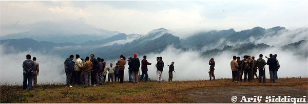
. They are not as rugged as the Himalayas and its peaks are much lower in height. Features of the range include conical peaks, steep slopes and deep valleys.
Three hill ranges come under the Patkai. The Patkai-Bum, the Garo-Khasi-Jaintia, and the Lushai Hills
Lushai hills
The Lushai Hills are part of the Patkai range in Mizoram and partially in Tripura, India.-Flora & Fauna:The hills are for the most part covered with dense bamboo jungle and rank undergrowth; but in the eastern portion, owing probably to a smaller rainfall, open grass-covered slopes are found, with...
. The Garo-Khasi range is in the Indian state of Meghalaya
Meghalaya
Meghalaya is a state in north-eastern India. The word "Meghalaya" literally means the Abode of Clouds in Sanskrit and other Indic languages. Meghalaya is a hilly strip in the eastern part of the country about 300 km long and 100 km wide, with a total area of about 8,700 sq mi . The...
. Mawsynram
Mawsynram
Mawsynram is a village in the East Khasi Hills district of Meghalaya state in north-eastern India, 56 kilometers from Shillong. It is reportedly the wettest place on Earth, with an annual rainfall of...
and Cherrapunji
Cherrapunji
Cherrapunji , is a subdivisional town in the East Khasi Hills district in the Indian state of Meghalaya. It is credited as being the second wettest place on Earth...
, on the windward side of these hills are the world's wettest places, having the highest annual rainfall.
Climate ranges from temperate to alpine due to altitude
Altitude
Altitude or height is defined based on the context in which it is used . As a general definition, altitude is a distance measurement, usually in the vertical or "up" direction, between a reference datum and a point or object. The reference datum also often varies according to the context...
.
The Pangsau Pass
Pangsau pass
Pangsau Pass, in altitude, lies on the crest of the Patkai Hills on the India-Burma border. The reputed route of the 13th century invasion of Assam in India by the Ahoms, a Shan tribe, the pass offers one of the easiest routes into Burma from the Assam plains...
offers the most important route through the Patkai. The Ledo Road
Ledo Road
The Ledo Road was built during World War II so that the Western Allies could supply the Chinese as an alternative to the Burma Road which had been cut by the Japanese in 1942. It was renamed the Stilwell Road in early 1945 at the suggestion of Chiang Kai-shek...
was built through Pangsau Pass as a strategic supply road built over the range during World War II
World War II
World War II, or the Second World War , was a global conflict lasting from 1939 to 1945, involving most of the world's nations—including all of the great powers—eventually forming two opposing military alliances: the Allies and the Axis...
to link India with the Burma Road
Burma Road
The Burma Road is a road linking Burma with the southwest of China. Its terminals are Kunming, Yunnan, and Lashio, Burma. When it was built, Burma was a British colony.The road is long and runs through rough mountain country...
into China
China
Chinese civilization may refer to:* China for more general discussion of the country.* Chinese culture* Greater China, the transnational community of ethnic Chinese.* History of China* Sinosphere, the area historically affected by Chinese culture...
.
See also
- Dehing Patkai FestivalDehing Patkai FestivalThe Dehing Patkai Festival is a once-a-year festival held at Lekhapani in Tinsukia district of Assam. The festival is named after the majestic Patkai range and the mischievous Dehing River. It is organized by the Government of Assam, providing the tourists with boundless chances for fun and...

