
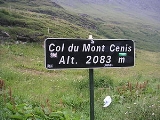
Mont Cenis
Encyclopedia
Massif
In geology, a massif is a section of a planet's crust that is demarcated by faults or flexures. In the movement of the crust, a massif tends to retain its internal structure while being displaced as a whole...
and pass
Mountain pass
A mountain pass is a route through a mountain range or over a ridge. If following the lowest possible route, a pass is locally the highest point on that route...
(el. 2081 m / 6827 ft) in Savoie
Savoie
Savoie is a French department located in the Rhône-Alpes region in the French Alps.Together with the Haute-Savoie, Savoie is one of the two departments of the historic region of Savoy that was annexed by France on June 14, 1860, following the signature of the Treaty of Turin on March 24, 1860...
in France
France
The French Republic , The French Republic , The French Republic , (commonly known as France , is a unitary semi-presidential republic in Western Europe with several overseas territories and islands located on other continents and in the Indian, Pacific, and Atlantic oceans. Metropolitan France...
which forms the limit between the Cottian
Cottian Alps
The Cottian Alps are a mountain range in the southwestern part of the Alps. They form the border between France and Italy...
and Graian Alps
Graian Alps
The Graian Alps are a mountain range in the western part of the Alps. They are located in France , Italy , and Switzerland...
.
A road over the pass was built between 1803 and 1810 by Napoleon
Napoleon I of France
Napoleon Bonaparte was a French military and political leader during the latter stages of the French Revolution.As Napoleon I, he was Emperor of the French from 1804 to 1815...
. A Fell mountain railway system
Fell mountain railway system
The Fell system uses a raised centre rail between the two running rails on steeply-graded railway lines to provide extra traction and braking, or braking alone. Trains are propelled by wheels or braked by shoes pressed horizontally onto the centre rail, as well as by means of the normal running...
, named after its inventor John Fell
John Barraclough Fell
John Barraclough Fell , was a British railway engineer and inventor of the Fell mountain railway system.Fell spent the early part of his life in London, living with his parents. About 1835 he moved with them to the Lake District. In 1840, he married a 25-year-old woman named Martha in Kirkstall,...
and worked by English engine-drivers, was opened alongside the road in 1868, but was dismantled in 1871, on the opening of the Mont Cenis Tunnel. For the railway through the tunnel see Fréjus Rail Tunnel
Fréjus Rail Tunnel
The Fréjus Rail Tunnel is a rail tunnel of length in the European Alps, carrying the Turin–Modane railway through Mount Cenis to an end on connection with the Culoz–Modane railway and linking Modane, France and Bardonecchia, Italy...
.
This tunnel (highest point 1295 m / 4249 ft) is really 27.4 km 17 miles west of the pass, below the Col du Fréjus
Col du Fréjus
Col du Fréjus is a mountain pass in the Cottian Alps on the border between France and Italy. It connects Bardonecchia in Italy to Modane in France.The road over the pass is not paved, and most traffic was rerouted by the Fréjus Road Tunnel....
. From Chambéry
Chambéry
Chambéry is a city in the department of Savoie, located in the Rhône-Alpes region in southeastern France.It is the capital of the department and has been the historical capital of the Savoy region since the 13th century, when Amadeus V of Savoy made the city his seat of power.-Geography:Chambéry...
the line runs up the Isère
Isère River
The Isère is a 286 km long river in southeastern France, in the Rhône-Alpes région. Its source is in the Alps on the border with Italy, near the ski resort Val d'Isère. It flows into the Rhône River in Pont-de-l'Isère, a few km north of Valence...
valley, but soon bears through that of the Arc
Arc (Savoie)
The Arc is a 128 km long river in the Savoie département of south-eastern France. It is a left tributary of the Isère River, which it joins at Chamousset, approximately 15 km downstream from Albertville. Its source is near the border with Italy, in the Graian Alps, northeast of Bonneval-sur-Arc...
or the Maurienne
Maurienne
Maurienne is one of the provinces of Savoy, corresponding to the arrondissement of Saint-Jean-de-Maurienne in France. It is also the original name of the capital of the province, now Saint-Jean-de-Maurienne.-Location:...
past Saint-Jean-de-Maurienne
Saint-Jean-de-Maurienne
Saint-Jean-de-Maurienne is a commune in the Savoie department in the Rhône-Alpes region in south-eastern France. It is a sub-prefecture of the department....
to Modane
Modane
Modane is a commune in the Savoie department in the Rhône-Alpes region in southeastern France.It was part of the Kingdom of Sardinia until 1860.-Transportation:...
(98.2 km / 61 mi from Chambéry). The tunnel is 13 km in length, and leads to Bardonecchia
Bardonecchia
Bardonecchia is an Italian town and comune located in the Province of Turin, in the Piedmont region, in the western part of Susa Valley....
, some way below which, at Oulx
Oulx
Oulx is a comune in the Province of Turin in the Italian region Piedmont, located about 70 km west of Turin, in the Susa Valley on the border with France.-Names:...
the line joins the road from the Col de Montgenèvre
Col de Montgenèvre
The Col de Montgenèvre is a high mountain pass in the Cottian Alps, between France and Italy.The pass takes its name from the village Montgenèvre , which lies in the vicinity...
.
Thence the valley of the Dora Riparia
Dora Riparia
The Dora Riparia is an Italian river, a left-hand tributary of the Po. It is 125 km long, with a 1,231 km² drainage basin. It originates in the Cottian Alps, close to the Col de Montgenèvre in France, where it is called the Piccola Dora...
is followed to Turin
Turin
Turin is a city and major business and cultural centre in northern Italy, capital of the Piedmont region, located mainly on the left bank of the Po River and surrounded by the Alpine arch. The population of the city proper is 909,193 while the population of the urban area is estimated by Eurostat...
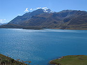
(103.8 km / 64.5 mi from Modane). The carriage road mounts the Arc valley for 25.7 km / 16 mi from Modane to Lanslebourg, whence it is 12.9 km / 8 mi to the hospice, a little way beyond the summit of the pass. The descent lies through the Cenis valley to Susa (49.9 km / 37 mi from Modane) where the road joins the railway.
To the southwest of the Mont Cenis is the Little Mont Cenis (2184.2 m / 7166 ft) which leads from the summit plateau (in Italy) of the main pass to the Etache valley on the French slope and so to Bramans
Bramans
Bramans is a commune in the Savoie department in the Rhône-Alpes region in south-eastern France....
in the Arc valley. This pass was crossed in 1689 by the Vaudois, and is believed by some authors to have been Hannibal's Pass.
History
Being a pass in the Alps, the Mont Cenis was used in several notable incidents in history. One example is the descent of Constantine I to Italy, to fight against MaxentiusMaxentius
Maxentius was a Roman Emperor from 306 to 312. He was the son of former Emperor Maximian, and the son-in-law of Emperor Galerius.-Birth and early life:Maxentius' exact date of birth is unknown; it was probably around 278...
. It was the principal route for crossing the Alps between France and Italy until the 19th century. It was also used as the main passage by which Charlemagne crossed with his army to invade Lombardy in 773.
See also
- List of highest paved roads in Europe
- List of mountain passes