Ringway 4
Encyclopedia

London Ringways
The London Ringways were a series of four ring roads planned in the 1960s to circle London at various distances from the city centre. They were part of a comprehensive scheme developed by the Greater London Council to alleviate traffic congestion on the city's road system by providing high speed...
, ring roads planned in the 1960s to circle London
London
London is the capital city of :England and the :United Kingdom, the largest metropolitan area in the United Kingdom, and the largest urban zone in the European Union by most measures. Located on the River Thames, London has been a major settlement for two millennia, its history going back to its...
at various distances from the city centre. They were part of a comprehensive scheme developed by the Greater London Council
Greater London Council
The Greater London Council was the top-tier local government administrative body for Greater London from 1965 to 1986. It replaced the earlier London County Council which had covered a much smaller area...
(GLC) to alleviate traffic congestion on the city's road system by providing high speed motorway-standard roads within the capital linking a series of radial roads taking traffic into and out of the city. Most of the scheme was cancelled in 1973.
- for a detailed history see London RingwaysLondon RingwaysThe London Ringways were a series of four ring roads planned in the 1960s to circle London at various distances from the city centre. They were part of a comprehensive scheme developed by the Greater London Council to alleviate traffic congestion on the city's road system by providing high speed...
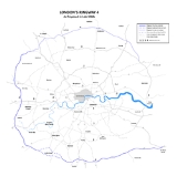
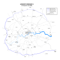
Ringway 4 was planned as a new rural motorway/dual carriageway
Dual carriageway
A dual carriageway is a class of highway with two carriageways for traffic travelling in opposite directions separated by a central reservation...
connecting a number of towns around the capital including Sevenoaks
Sevenoaks
Sevenoaks is a commuter town situated on the London fringe of west Kent, England, some 20 miles south-east of Charing Cross, on one of the principal commuter rail lines from the capital...
, Redhill
Redhill, Surrey
Redhill is a town in the borough of Reigate and Banstead, Surrey, England and is part of the London commuter belt. Redhill and the adjacent town of Reigate form a single urban area.-History:...
/Reigate
Reigate
Reigate is a historic market town in Surrey, England, at the foot of the North Downs, and in the London commuter belt. It is one of the main constituents of the Borough of Reigate and Banstead...
, Leatherhead
Leatherhead
Leatherhead is a town in the County of Surrey, England, on the River Mole, part of Mole Valley district. It is thought to be of Saxon origin...
, Staines
Staines
Staines is a Thames-side town in the Spelthorne borough of Surrey and Greater London Urban Area, as well as the London Commuter Belt of South East England. It is a suburban development within the western bounds of the M25 motorway and located 17 miles west south-west of Charing Cross in...
, Uxbridge
Uxbridge
Uxbridge is a large town located in north west London, England and is the administrative headquarters of the London Borough of Hillingdon. It forms part of the ceremonial county of Greater London. It is located west-northwest of Charing Cross and is one of the major metropolitan centres...
, Watford
Watford
Watford is a town and borough in Hertfordshire, England, situated northwest of central London and within the bounds of the M25 motorway. The borough is separated from Greater London to the south by the urbanised parish of Watford Rural in the Three Rivers District.Watford was created as an urban...
, St Albans
St Albans
St Albans is a city in southern Hertfordshire, England, around north of central London, which forms the main urban area of the City and District of St Albans. It is a historic market town, and is now a sought-after dormitory town within the London commuter belt...
, Hatfield
Hatfield, Hertfordshire
Hatfield is a town and civil parish in Hertfordshire, England in the borough of Welwyn Hatfield. It has a population of 29,616, and is of Saxon origin. Hatfield House, the home of the Marquess of Salisbury, is the nucleus of the old town...
, Hertford
Hertford
Hertford is the county town of Hertfordshire, England, and is also a civil parish in the East Hertfordshire district of the county. Forming a civil parish, the 2001 census put the population of Hertford at about 24,180. Recent estimates are that it is now around 28,000...
and Hoddesdon
Hoddesdon
Hoddesdon is a town in the English county of Hertfordshire, situated in the Lea Valley. The town grew up as a coaching stop on the route between Cambridge and London. It is located southeast of Hertford, north of Waltham Cross and southwest of Bishop's Stortford. At its height during the 18th...
.
Despite its name, the route of Ringway 4 did not make a complete circuit of London. It was, instead, U-shaped. The planned route started at a junction with the M20 motorway
M20 motorway
The M20 is a motorway in Kent, England. It runs from the M25 motorway to Folkestone, providing a link to the Channel Tunnel and the ports at Dover. It is long...
(then also being planned) near Wrotham
Wrotham
Wrotham is a village situated on the Pilgrims' Way in Kent, at the foot of the North Downs. It is located one mile north of Borough Green and approximately five miles east of Sevenoaks. It is within the junction of the M20 and M26 motorways....
in Kent
Kent
Kent is a county in southeast England, and is one of the home counties. It borders East Sussex, Surrey and Greater London and has a defined boundary with Essex in the middle of the Thames Estuary. The ceremonial county boundaries of Kent include the shire county of Kent and the unitary borough of...
and ran west as motorway around the capital to Hunton Bridge near Watford. From Watford the road was to become dual carriageway heading east until it met Ringway 3
Ringway 3
Ringway 3 was the third from the centre of the series of four London Ringways, ring roads planned in the 1960s to circle London at various distances from the city centre...
near Navestock
Navestock
Navestock is a civil parish in the Borough of Brentwood in south Essex, in the East of England region of the United Kingdom. It is located approximately North West of the town of Brentwood and the M25 motorway cuts through the western edge of the parish. It covers an area of in excess of 1800...
in Essex
Essex
Essex is a ceremonial and non-metropolitan county in the East region of England, and one of the home counties. It is located to the northeast of Greater London. It borders with Cambridgeshire and Suffolk to the north, Hertfordshire to the west, Kent to the South and London to the south west...
. The designation for the motorway section was M25
M25 motorway
The M25 motorway, or London Orbital, is a orbital motorway that almost encircles Greater London, England, in the United Kingdom. The motorway was first mooted early in the 20th century. A few sections, based on the now abandoned London Ringways plan, were constructed in the early 1970s and it ...
.
Construction began on the first section of the motorway between Godstone
Godstone
Godstone is a village in the county of Surrey, England. It is located approximately six miles east of Reigate at the junction of the A22 and A25 major roads, and near the M25 motorway.-History:...
and Reigate (junctions 6 to 8) in 1973 and included a junction with the M23 motorway
M23 motorway
The M23 motorway is a motorway in England. The motorway runs from south of Hooley in Surrey, where it splits from the A23, to Pease Pottage, south of Crawley in West Sussex where it rejoins the A23. The northern end of the motorway starts at junction 7 on what is effectively a spur north from...
which was under construction at the same time.
Whilst the construction of the first section was in progress, the plan for Ringways 3 and 4 was modified considerably. Broadly speaking, the motorway section of Ringway 4 was to be built and connected to the northern and eastern section of Ringway 3 (from the current M25 junction 23 with the A1 clockwise to the current junction 3 with the M20) Two additional sections of motorway were added to the plan to join the two original sections and the remaining parts of the two rings were cancelled. The south-eastern section of Ringway 4 between Wrotham and Sevenoaks was redesignated as the M26
M26 motorway
The M26 is a motorway in Kent, England. It provides a short link between the M25/A21 at Sevenoaks and the M20 near Wrotham.-Route:The motorway starts at junction 3 of the M20 and heads west, encountering almost immediately the single junction along its length where it has an interchange with the A20...
.
- for more information on the route of the southern and western sections of Ringway 4 see M25 motorwayM25 motorwayThe M25 motorway, or London Orbital, is a orbital motorway that almost encircles Greater London, England, in the United Kingdom. The motorway was first mooted early in the 20th century. A few sections, based on the now abandoned London Ringways plan, were constructed in the early 1970s and it ...
Except for a deviation from the original plan around Leatherhead, the current M26 and the M25 between junctions 5 and 19 mostly follow the planned route of Ringway 4.
The Godstone to Reigate section was opened in 1976 and the remaining sections of the southern Ringway 4 were constructed over the next ten years.
One short section of the dual carriage way portion of Ringway 4 was constructed in Hoddesdon linking the town to the A10. The overly large junction between the link road and the A10 was built with space available to continue the road westward over the A10 as originally planned.
See also
Other London Ringways- Ringway 1Ringway 1Ringway 1 or the London Motorway Box was the innermost of the series of four motorway standard roads, known as the London Ringways as part of a comprehensive scheme developed by the Greater London Council to provide high speed motorway-standard roads within the capital linking a series of radial...
- Ringway 2Ringway 2Ringway 2 was the second innermost of the series of four London Ringways, ring roads planned in the 1960s to circle London at various distances from the city centre...
- Ringway 3Ringway 3Ringway 3 was the third from the centre of the series of four London Ringways, ring roads planned in the 1960s to circle London at various distances from the city centre...
- Homes before RoadsHomes before RoadsHomes before Roads was a 1970s political movement and campaign in the United Kingdom initially formed in London in 1970 to oppose plans to construct a system of four interlinked concentric motorways through and around London, known as Ringways...

