

M25 motorway
Encyclopedia
The M25 motorway, or London Orbital, is a 117 miles (188.3 km) orbital motorway that almost encircles Greater London
, England, in the United Kingdom. The motorway was first mooted early in the 20th century
. A few sections, based on the now abandoned London Ringways
plan, were constructed in the early 1970s and it was completed in 1986. The M25 is one of the world's longest orbital roads and one of the busiest and most congested parts of the British motorway network. 196,000 vehicles were recorded in a single day near London Heathrow Airport
. Plans to widen additional sections to eight lanes (four each way) were scaled back in 2009 in response to rising costs.
on other sections.
The M25 is not a continuous loop. To the east of London, the charged crossing of the Thames between Thurrock
and Dartford
is the lesser grade A282
. The Dartford Crossing
, which consists of two tunnels and the QE2 (Queen Elizabeth II) bridge, is named Canterbury Way. Passage across the bridge or through the tunnels is subject to a road user charge (congestion charge
), depending on the kind of vehicle. Making this stretch a motorway would stop any traffic not permitted to use motorways from crossing the Thames
east of the Woolwich Ferry
.
At junction 5 near Sevenoaks
, drivers continuing around the M25 in either direction must follow the slip roads. The anticlockwise carriageway continues eastward as the M26
(towards the M20
); the clockwise carriageway continues towards the south coast as the A21.
The distance of the motorway from central London (taken as Charing Cross
) varies from about 12 miles (19.3 km) near Potters Bar
to 20 miles (32.2 km) near Byfleet. In some places (Enfield, Hillingdon and Havering) the Greater London boundary has been realigned to the M25 for minor stretches; while in others, most notably in Essex and Surrey, it is many miles distant. Major towns such as Epsom
, Watford
, and Loughton
are within the M25. North Ockendon
is the only settlement of Greater London situated outside the M25. In 2004, following an opinion poll, a move was mooted by the London Assembly
to align the Greater London boundary with the M25. "Inside the M25" and "outside the M25" or "beyond the M25" are used colloquially to refer to London and the provinces; the Communications Act 2003
explicitly uses the M25 as the boundary in requiring a proportion of television programmes to be made outside the London area.
The three service areas
are located in the central north (Junction 23 South Mimms
), south east (Clacket Lane
) and central east (Thurrock
). A fourth is due to open near Cobham
in 2012.
Much of the M25 is lit to help reduce accidents. The current illuminated sections are from Dartford to junction 3, junction 5, junctions 6 to 21a and junctions 23 to 31. The type of lighting varies. Some sections use the older yellow low-pressure sodium
(SOX) lighting while others use modern high-pressure sodium (SON) lighting. Some stretches have recently been upgraded to SON lighting. These include Junction 5, junctions around Heathrow and Junction 27.
The motorway passes through several police areas. Junctions 1–5 are in Kent
, 6–14 in Surrey
(passing in places through Greater London and Berkshire), 15–16 are in Buckinghamshire
, 17–24 are in Hertfordshire
, 25 in Greater London
(the Hertfordshire border going around the junction's northern edge), 26–28 in Essex
, 29 in Greater London and 30–31 in Essex. Policing the road is carried out by an integrated policing group made up of the Metropolitan
, Thames Valley
, Essex
, Kent
, Hertfordshire
and Surrey
forces.
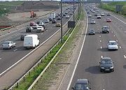
The M25 is one of Europe's busiest motorways. In 2003, 196,000 vehicles a day were recorded on the motorway near London Heathrow Airport
between junctions 13 and 14.

 A precursor of the M25 was the North Orbital Road (see A414 road
).
The idea of an orbital road around London was first proposed early in the 20th century and then re-examined in Sir Charles Bressey's
and Sir Edwin Lutyens'
The Highway Development Survey, 1937. Sir Patrick Abercrombie's
County of London Plan
, 1943 and Greater London Plan, 1944 proposed a series of five roads encircling the capital. The northern sections of the M25 follow a similar route to the World War II
Outer London Defence Ring
.
Little was done to progress these plans until the 1960s when the Greater London Council
developed their London Ringways
plan which consisted of four 'rings' around the capital. Sections of the two outer rings - Ringway 3
(the 'M16 motorway
') and Ringway 4
were constructed in the early 1970s and these were later integrated into the single M25 orbital motorway. The Ringways plan was however hugely controversial due to the destruction required for the inner two ring roads (Ringway 1
and Ringway 2
). Parts of Ringway 1 were constructed (including West Cross Route
and Westway
) against stiff opposition before the overall plan was abandoned in 1973 following pressure from residents in the threatened areas.
Construction of parts of the two outer ring roads, Ringways 3
and 4
, were however started in 1973. The first section, between South Mimms and Potters Bar in Hertfordshire (junction 23 to junction 24) opened in September 1975 and was given the temporary general purpose road designation A1178; a section south of London 1976 (junction 6 to junction 8) opened in 1976. A section of Ringway 3 south of the river between Dartford and Swanley (junction 1 to junction 3) was constructed between 1974 and 1977.
In 1975 the plans for Ringway 3 were modified to combine it with Ringway 4, the outermost Ringway. The combined motorway was given the designation M25 which had originally been intended for the southern and western part of Ringway 4 and the M16 designation was dropped. The section of Ringway 3 west of South Mimms anti-clockwise around London to Swanley in Kent was cancelled. The stages were not constructed contiguously but in small sections. As the orbital road developed the sections were linked. Each section was presented to planning authorities in its own right and was individually justified, with almost 40 public inquiries relating to sections of the route. Maps at this time depicting these short sections named the route as the M16 but this changed before completion.
The section from Potters Bar to the Dartford Tunnel was constructed between 1979 and 1982. Construction of the M25 continued in stages until its completion in 1986. Prime Minister
Margaret Thatcher
officially opened the M25 on 29 October 1986, with a ceremony in the section between J22 and J23 (London Colney
and South Mimms
). The initial tenders for the construction of the M25 totalled £631.9 million. This did not include compulsory purchase of land and subsequent upgrades and repairs.
In 1995 a contract was awarded to widen the section between junctions 8 and 10 from six to eight lanes for a cost of £93.4 million and a Motorway Incident Detection and Automatic Signalling
(MIDAS) system was introduced to the M25 from junction 10 to junction 15 at a cost of £13.5m in 1995 and then extended to junction 16 at a cost of £11.7m in 2002. This consists of a distributed network of traffic and weather sensors, speed cameras and variable-speed signs that control traffic speeds with little human supervision, and has improved traffic flow slightly, and reduced the amount of start-stop driving.
In 1995 there was a proposal to widen the section close to Heathrow Airport to 14 lanes. This attracted fierce opposition from road protesters opposing the Newbury Bypass
and other schemes and it was cancelled shortly afterwards. However, in 1997 the Department of Transport announced new proposals to widen the section from junction 12 (M3) and junction 15 (M4) to 12 lanes. At the Terminal Five public inquiry a Highways Agency official said that the widening was needed to accommodate traffic to the proposed new terminal, however the transport minister said that no such evidence had been given. Environmental groups objected to the decision to go ahead a scheme that would create the widest motorways in the UK without holding a public inquiry
. The decision was again deferred. A decision to go-ahead was given for a 10-lane scheme in 1998 and the £148 million 'M25 Jct 12 to 15 Widening' contract was awarded to Balfour Beatty
in 2003. The scheme was completed in 2005 as dual-five lane between junctions 12 to 14 and dual six lanes from 14 to 15.
In 2007 capacity at junction 25 (A10/Waltham Cross) was increased and the Holmesdale Tunnel was widened to 3 lanes in an eastern direction at a cost of £75 million.
Work to widen the exit slip-roads in both directions at Junction 28 (A12 road/A1023) was completed in 2008. It was designed to reduce the amount of traffic queueing on the slip roads at busy periods, particularly traffic from the clockwise M25 joining the northbound A12 where the queue can extend onto the inside lane of the Motorway.
In 2009 a £6.2 billion M25 'Design, Build, Finance and Operate' (DBFO) private finance initiative
contract was awarded to Connect Plus to widen the sections between junctions 16 and 23 and between junctions 27 and 30 and maintain the M25 and the Dartford Crossing for a 30 year period.
with hard shoulder running
on the M25 from Junctions 5 to 7 (M26 – M23/Redhill) with work starting after the London Olympics in 2012/3.
on the M25 from Junctions 23 to 27 (A1(M)-M11) with work starting after the London Olympics in 2013, opening in 2016.
Delivery Plan is underway although there is no guarantee of delivery. Plans were announced in 2007. An early estimate on the start of major works was given as 2013/2014. Philip Hammond
has confirmed that there will be no funding for the J30 improvements in this spending period, but has announced that preparation work would continue so that the scheme could be funded at a later date.
using the M60 motorway
, Birmingham
using parts of the M5
, M6
and M42
and from 2011 Glasgow will have an orbital motorway made of the M8, M73
and M74
although one section of the route passes through the centre of the city. The M25 is the second-longest ring road in Europe, after the Berlin Ring (A 10
) which is 5 miles (8 km) longer. The M25 is one of the busiest motorways in Europe:
's book and film, London Orbital which was published in 2003 is based on a year long journey around the M25 on foot.
The M25 (including the A282 Dartford Crossing
) is known for its frequent traffic jams. These have been the subject of so much comment from such an early stage that even at the official opening ceremony Margaret Thatcher
complained about "those who carp and criticise". The jams have inspired jokes ("the world's biggest car park", "the London Orbital Car Park") and songs (Chris Rea
's "The Road to Hell
").
The M25 plays an important role in the comedy-fantasy novel Good Omens
, being "evidence for the hidden hand of Satan in the affairs of Man".
The road enjoyed a more positive reputation among raver
s in the late 1980s as the then new Orbital Motorway was a popular route to the parties that took place around the outskirts of London. The use of the M25 for these raves inspired the name of electronic duo Orbital
.
 The orbital nature of the motorway, in common with racetracks, lent itself to unofficial, and illegal, motor racing
. At the end of the 1980s, before the advent of speed enforcement devices, owners of supercars, many employed in the financial service industry in the City
and in Docklands, would meet at night at service stations such as South Mimms
and conduct time trials. Times below 1 hour were achieved; an average speed of over 117 mph (188 km/h), which included coming to a halt at the Dartford Tunnel road user charge payment booths.
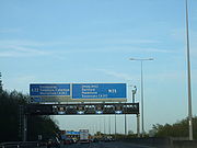
from driver location signs
provide carriageway identifier information. The numbers on the signs are kilometres from a point near the River Thames, east of London, when travelling clockwise on the motorway. The table below gives details of each junction, including the roads interchanged and the destinations that are signed from the motorway. Figures in kilometres are from the driver location signs; figures in miles are derived from them.
{| class="wikitable"
|- align="center" bgcolor="00703C" style="color: #FFD200;font-size:120%;"
| colspan="5" | A282 Road - Dartford Crossing
|-
!scope=col| mi
!scope=col| km
!scope=col| Clockwise exits (A Carriageway)
!scope=col| Junction
!scope=col| Anti-clockwise exits (B Carriageway)
|- align="center"
|
|
|Dartford Crossing
A282
Dartford Tunnel
|River
|Dartford Crossing A282
Queen Elizabeth Bridge
|- align="center"
|3.5
|5.7
| Erith
A206
| J1a
| Erith A206, Swanscombe
(A226
)
|- align="center"
|4.7
|7.5
| Dartford
A225
| J1b
| Exit via J2 - Dartford (A225
)
|- align="center" bgcolor="0080d0" style="color: white;font-size:120%;"
| colspan="5" | M25 Motorway - London Orbital
|-
|- align="center"
|5.5
|8.8
| London (South East), Canterbury A2, (M2), Bluewater
| J2
| London (SE & C)
, Lewisham
A2(W)
, Canterbury
A2(E) (M2
), Dartford (A225)
|- align="center"
|8.7
|14.0
| London (South East) A20
Maidstone
M20
Swanley
B2173
| J3
| Maidstone
, Channel Tunnel
M20
London (SE & C), Lewisham A20
|- align="center"
|12.2
|19.6
| Bromley
A21
Orpington
A224
| J4
| Bromley, London (SE)
A21
Orpington (A224)
|- align="center"
|16.3–16.4
|26.2–26.4
| Sevenoaks
, Royal Tunbridge Wells
, Hastings
A21
| J5
| Maidstone, Channel Tunnel, Dover
M26
(M20)
Sevenoaks, Hastings A21
|- align="center"
|21.0
|33.8
|Clacket Lane services
|Services
|Clacket Lane services
|- align="center"
|25.8
|41.6
| East Grinstead
, Eastbourne
, Caterham
, Godstone
A22
Westerham
(A25
)
| J6
| Eastbourne, Caterham, Godstone A22, Westerham
(A25)
|- align="center"
|28.6
|46.0
| Gatwick Airport, Crawley
, Brighton
, East Grinstead, Croydon
M23
| J7
| Gatwick, Brighton, M23(S), Croydon M23(N)
|- align="center"
|31.9
|51.4
| Reigate
, Sutton A217
Redhill
(A25)
| J8
| Reigate, Sutton
A217
Redhill (A25
)
|- align="center"
|38.5 -
39.5
|62.0 -
63.5
| Leatherhead
A243
Dorking
(A24
)
| J9
| Leatherhead A243
Dorking (A24)
|- align="center"
|42.6 -
43.2
|68.6 -
69.5
|bgcolor=#ffdead| Cobham Services
(Scheduled opening 2012)
|Services
|bgcolor=#ffdead|Cobham Services
|- align="center"
|45.0
|72.4
| London (South West), Sutton, Guildford
, Portsmouth
A3
| J10
| London (South West), Guildford, Portsmouth
, A3
|- align="center"
|49.8
|80.2
| Chertsey
A317
Woking
A320
| J11
| Woking A320
Chertsey A317
|- align="center"
|52.1
|83.8
| Basingstoke
, Southampton
, Richmond M3
| J12
| Basingstoke, Southampton, Richmond M3
|- align="center"
|55.2
|88.8
| Staines
A30
| J13
| London (West), Staines, Windsor
A30
|- align="center"
|57.0
|91.8
| Heathrow Airport (Terminals 4, 5 and Cargo) A3113 dedicated spur
| J14
| Heathrow Airport (Terminals 4, 5 and Cargo) A3113 dedicated spur
|- align="center"
|59.0
|95.0
| The WEST
, Slough
, Reading
, London (West), Heathrow Airport (Terminals 1, 2 and 3) M4
| J15
| The WEST, Slough, Reading M4(W)
London (W)
, Heathrow (Terminals 1, 2 & 3) M4(E)
|- align="center"
|63.8
|102.6
| THE NORTH Birmingham
, Oxford
, Uxbridge
, London (W,C) M40
| J16
| Birmingham, Oxford M40(W)
Uxbridge, London (W & C)
M40(E)
|- align="center"
|68.7
|110.5
| Maple Cross
(A412
)
| J17
| Maple Cross A412
|- align="center"
|69.9
|112.5
| Rickmansworth, Chorleywood
, Amersham
A404
| J18
| Chorleywood, Amersham, Rickmansworth
A404
|- align="center"
|
|
| Watford
A41
| J19
| No Exit
|- align="center"
|73.8
|118.7
| Hemel Hempstead
, Aylesbury
A41
| J20
| Hemel Hempstead, Aylesbury, Watford
A41
|- align="center"
|76.3
|122.8
| The NORTH
, Luton
& Airport M1
| J21
| The NORTH, Luton & Airport M1
|- align="center"
|76.9
|123.7
| Watford A405
Harrow
(M1 South)
| J21A
| St Albans
A405
London (North West) (M1 (South))
|- align="center"
|80.6
|129.7
| London Colney A1081
| J22
| St Albans
A1081
|- align="center"
|83.3
|134.0
| Hatfield
A1(M)
London (North West) A1
Barnet
A1081
South Mimms services
| J23
Services
| Hatfield A1(M), London (NW)
A1
Barnet A1081, Services
|- align="center"
|85.9
|138.2
| Potters Bar
A111
| J24
| Potters Bar A111
|- align="center"
|91.4
|147.1
| Enfield Town
, Hertford
A10
| J25
| Enfield, Hertford, London (N & C)
A10
|- align="center"
|94.9
|152.7
| Waltham Abbey
, Loughton
A121
| J26
| Waltham Abbey, Loughton A121
|- align="center"
|99.2
|159.7
| London (NE), Stansted Airport, Harlow
, Cambridge
M11
| J27
| London (NE & C)
M11(N)
, Stansted, Harlow, Cambridge M11(S)
|- align="center"
|107.1
|172.4
| Chelmsford
, Witham
, Colchester
A12
Brentwood
A1023
| J28
| Chelmsford, Romford
A12
Brentwood A1023
|- align="center"
|109.9
|176.8
| Romford, Basildon
, Southend A127
| J29
| Basildon, Southend, Romford
A127
|- align="center"
|115.2
|185.4
| Dagenham, Rainham, Tilbury, Barking
, London (E & C) A13
Thurrock services
| J30
| Dagenham
, Rainham, Tilbury
, Basildon
, London (E & C)
A13, West Thurrock (A126)
|- align="center"
|- align="center" bgcolor="00703C" style="color: #FFD200;font-size:120%;"
| colspan="5" | A282 Road - Dartford Crossing
|- align="center"
|115.9
|186.6
| Access via J30
|| J31
Services
| Thurrock
(Lakeside
), Services
A1306, Purfleet
(A1090), West Thurrock
(A126)
|- align="center"
|
|
|Dartford Crossing
A282
Dartford Tunnel
|River
|Dartford Crossing A282
Queen Elizabeth Bridge
Anti-clockwise information above gathered from Advanced Direction Signs August 2011 (J9 - J22, J20 - J15)
Greater London
Greater London is the top-level administrative division of England covering London. It was created in 1965 and spans the City of London, including Middle Temple and Inner Temple, and the 32 London boroughs. This territory is coterminate with the London Government Office Region and the London...
, England, in the United Kingdom. The motorway was first mooted early in the 20th century
20th century
Many people define the 20th century as running from January 1, 1901 to December 31, 2000, others would rather define it as beginning on January 1, 1900....
. A few sections, based on the now abandoned London Ringways
London Ringways
The London Ringways were a series of four ring roads planned in the 1960s to circle London at various distances from the city centre. They were part of a comprehensive scheme developed by the Greater London Council to alleviate traffic congestion on the city's road system by providing high speed...
plan, were constructed in the early 1970s and it was completed in 1986. The M25 is one of the world's longest orbital roads and one of the busiest and most congested parts of the British motorway network. 196,000 vehicles were recorded in a single day near London Heathrow Airport
London Heathrow Airport
London Heathrow Airport or Heathrow , in the London Borough of Hillingdon, is the busiest airport in the United Kingdom and the third busiest airport in the world in terms of total passenger traffic, handling more international passengers than any other airport around the globe...
. Plans to widen additional sections to eight lanes (four each way) were scaled back in 2009 in response to rising costs.
Description
Originally built as a dual three-lane motorway, much of the motorway has subsequently been widened to dual four-lanes in places and to a dual five-lane section between junctions 12 and 14 and a dual six-lane between junctions 14 and 15. Further widening is in progress with plans for managed motorwaysManaged motorways in the United Kingdom
Managed motorways are motorways with technology to allow variable speed limits to be applied and hard shoulder running.-Background:The first section of motorway in the UK to use this technique was the M42 in the West Midlands...
on other sections.
The M25 is not a continuous loop. To the east of London, the charged crossing of the Thames between Thurrock
Thurrock
Thurrock is a unitary authority with borough status in the English ceremonial county of Essex. It is part of the London commuter belt and an area of regeneration within the Thames Gateway redevelopment zone. The local authority is Thurrock Council....
and Dartford
Dartford
Dartford is the principal town in the borough of Dartford. It is situated in the northwest corner of Kent, England, east south-east of central London....
is the lesser grade A282
A282 road
The A282 is a road that includes the Dartford Crossing across the River Thames between Essex and Kent in England. It forms part of the London Orbital connecting junctions 2 and 31 of the M25, and a part of the unsigned Euroroute E15. It has junctions numbered to fit inside the sequence of the M25...
. The Dartford Crossing
Dartford Crossing
The Dartford - Thurrock River Crossing, Dartford River Crossing is a major road crossing of the River Thames in England, connecting Dartford in the south to Thurrock in the north, via two road tunnels and the Queen Elizabeth II Bridge. It opened in stages, the west tunnel in 1963, the east tunnel...
, which consists of two tunnels and the QE2 (Queen Elizabeth II) bridge, is named Canterbury Way. Passage across the bridge or through the tunnels is subject to a road user charge (congestion charge
Congestion pricing
Congestion pricing or congestion charges is a system of surcharging users of a transport network in periods of peak demand to reduce traffic congestion. Examples include some toll-like road pricing fees, and higher peak charges for utilities, public transport and slots in canals and airports...
), depending on the kind of vehicle. Making this stretch a motorway would stop any traffic not permitted to use motorways from crossing the Thames
River Thames
The River Thames flows through southern England. It is the longest river entirely in England and the second longest in the United Kingdom. While it is best known because its lower reaches flow through central London, the river flows alongside several other towns and cities, including Oxford,...
east of the Woolwich Ferry
Woolwich Ferry
The Woolwich Free Ferry is a boat service across the River Thames, London, UK, which is licensed and financed by London River Services, the maritime arm of Transport for London...
.
At junction 5 near Sevenoaks
Sevenoaks
Sevenoaks is a commuter town situated on the London fringe of west Kent, England, some 20 miles south-east of Charing Cross, on one of the principal commuter rail lines from the capital...
, drivers continuing around the M25 in either direction must follow the slip roads. The anticlockwise carriageway continues eastward as the M26
M26 motorway
The M26 is a motorway in Kent, England. It provides a short link between the M25/A21 at Sevenoaks and the M20 near Wrotham.-Route:The motorway starts at junction 3 of the M20 and heads west, encountering almost immediately the single junction along its length where it has an interchange with the A20...
(towards the M20
M20 motorway
The M20 is a motorway in Kent, England. It runs from the M25 motorway to Folkestone, providing a link to the Channel Tunnel and the ports at Dover. It is long...
); the clockwise carriageway continues towards the south coast as the A21.
The distance of the motorway from central London (taken as Charing Cross
Charing Cross
Charing Cross denotes the junction of Strand, Whitehall and Cockspur Street, just south of Trafalgar Square in central London, England. It is named after the now demolished Eleanor cross that stood there, in what was once the hamlet of Charing. The site of the cross is now occupied by an equestrian...
) varies from about 12 miles (19.3 km) near Potters Bar
Potters Bar
Potters Bar is a town in the Hertsmere borough of Hertfordshire, England, located north of Central London. In 2001 it had a population of 21,618....
to 20 miles (32.2 km) near Byfleet. In some places (Enfield, Hillingdon and Havering) the Greater London boundary has been realigned to the M25 for minor stretches; while in others, most notably in Essex and Surrey, it is many miles distant. Major towns such as Epsom
Epsom
Epsom is a town in the borough of Epsom and Ewell in Surrey, England. Small parts of Epsom are in the Borough of Reigate and Banstead. The town is located south-south-west of Charing Cross, within the Greater London Urban Area. The town lies on the chalk downland of Epsom Downs.-History:Epsom lies...
, Watford
Watford
Watford is a town and borough in Hertfordshire, England, situated northwest of central London and within the bounds of the M25 motorway. The borough is separated from Greater London to the south by the urbanised parish of Watford Rural in the Three Rivers District.Watford was created as an urban...
, and Loughton
Loughton
Loughton is a town and civil parish in the Epping Forest district of Essex. It is located between 11 and 13 miles north east of Charing Cross in London, south of the M25 and west of the M11 motorway and has boundaries with Chingford, Waltham Abbey, Theydon Bois, Chigwell and Buckhurst Hill...
are within the M25. North Ockendon
North Ockendon
North Ockendon is an outlying settlement of northeast London, England and part of the London Borough of Havering. It is located east northeast of Charing Cross and consists of a dispersed settlement within the Metropolitan Green Belt...
is the only settlement of Greater London situated outside the M25. In 2004, following an opinion poll, a move was mooted by the London Assembly
London Assembly
The London Assembly is an elected body, part of the Greater London Authority, that scrutinises the activities of the Mayor of London and has the power, with a two-thirds majority, to amend the mayor's annual budget. The assembly was established in 2000 and is headquartered at City Hall on the south...
to align the Greater London boundary with the M25. "Inside the M25" and "outside the M25" or "beyond the M25" are used colloquially to refer to London and the provinces; the Communications Act 2003
Communications Act 2003
The Communications Act 2003 is an Act of the Parliament of the United Kingdom. It gave regulation body Ofcom its full powers. Among other measures, it introduced legal recognition of Community Radio and paved the way for full-time Community Radio services in the UK; as well as controversially...
explicitly uses the M25 as the boundary in requiring a proportion of television programmes to be made outside the London area.
The three service areas
Motorway service area
In the UK motorway service areas, also known as service stations, are places where drivers can leave a motorway to refuel, rest, or take refreshments. The vast majority of motorway services in the UK are owned by one of three companies: Moto, Welcome Break and RoadChef. Extra are also developing a...
are located in the central north (Junction 23 South Mimms
South Mimms services
South Mimms services is a motorway service station operated by Welcome Break at the junction of the M25 motorway and the A1 at Bignell's Corner north of London. The siting of the motorway service area has often been criticised, as it is at a heavily congested motorway-motorway intersection. When...
), south east (Clacket Lane
Clacket Lane services
Clacket Lane services is a motorway service station on the M25 motorway in Surrey, United Kingdom that is owned by RoadChef. Services are located on either side of the motorway between Westerham, Kent and Limpsfield, Surrey....
) and central east (Thurrock
Thurrock services
Thurrock services is a motorway service station on the M25 motorway in Thurrock, Essex. It is owned by Moto. The services were opened sometime between 1990 and 1992 .Parts of the service station overlook a lake.-References:...
). A fourth is due to open near Cobham
Cobham, Surrey
Cobham is a town in the Borough of Elmbridge in Surrey, England, about south-west of central London and north of Leatherhead. Elmbridge has been acclaimed by the Daily Mail as the best place to live in the UK, and Cobham is a prosperous part of the London commuter belt...
in 2012.
Much of the M25 is lit to help reduce accidents. The current illuminated sections are from Dartford to junction 3, junction 5, junctions 6 to 21a and junctions 23 to 31. The type of lighting varies. Some sections use the older yellow low-pressure sodium
Sodium vapor lamp
A sodium vapor lamp is a gas discharge lamp that uses sodium in an excited state to produce light. There are two varieties of such lamps: low pressure and high pressure...
(SOX) lighting while others use modern high-pressure sodium (SON) lighting. Some stretches have recently been upgraded to SON lighting. These include Junction 5, junctions around Heathrow and Junction 27.
The motorway passes through several police areas. Junctions 1–5 are in Kent
Kent
Kent is a county in southeast England, and is one of the home counties. It borders East Sussex, Surrey and Greater London and has a defined boundary with Essex in the middle of the Thames Estuary. The ceremonial county boundaries of Kent include the shire county of Kent and the unitary borough of...
, 6–14 in Surrey
Surrey
Surrey is a county in the South East of England and is one of the Home Counties. The county borders Greater London, Kent, East Sussex, West Sussex, Hampshire and Berkshire. The historic county town is Guildford. Surrey County Council sits at Kingston upon Thames, although this has been part of...
(passing in places through Greater London and Berkshire), 15–16 are in Buckinghamshire
Buckinghamshire
Buckinghamshire is a ceremonial and non-metropolitan home county in South East England. The county town is Aylesbury, the largest town in the ceremonial county is Milton Keynes and largest town in the non-metropolitan county is High Wycombe....
, 17–24 are in Hertfordshire
Hertfordshire
Hertfordshire is a ceremonial and non-metropolitan county in the East region of England. The county town is Hertford.The county is one of the Home Counties and lies inland, bordered by Greater London , Buckinghamshire , Bedfordshire , Cambridgeshire and...
, 25 in Greater London
Greater London
Greater London is the top-level administrative division of England covering London. It was created in 1965 and spans the City of London, including Middle Temple and Inner Temple, and the 32 London boroughs. This territory is coterminate with the London Government Office Region and the London...
(the Hertfordshire border going around the junction's northern edge), 26–28 in Essex
Essex
Essex is a ceremonial and non-metropolitan county in the East region of England, and one of the home counties. It is located to the northeast of Greater London. It borders with Cambridgeshire and Suffolk to the north, Hertfordshire to the west, Kent to the South and London to the south west...
, 29 in Greater London and 30–31 in Essex. Policing the road is carried out by an integrated policing group made up of the Metropolitan
Metropolitan Police Service
The Metropolitan Police Service is the territorial police force responsible for Greater London, excluding the "square mile" of the City of London which is the responsibility of the City of London Police...
, Thames Valley
Thames Valley Police
Thames Valley Police, formerly known as Thames Valley Constabulary, is the territorial police force responsible for policing the Thames Valley area covered by the ceremonial counties of Berkshire, Buckinghamshire and Oxfordshire....
, Essex
Essex Police
Essex Police is a territorial police force responsible for policing the county of Essex in the east of England.It is one of the largest non-metropolitan police forces in the United Kingdom, employing approximately 3,600 police officers and operating across an area of over and with a population of...
, Kent
Kent Police
Kent Police is the territorial police force for Kent in England, including the unitary authority of Medway.-Area and organisation:The force covers an area of with an approximate population of 1,660,588 . The Chief Constable is currently Ian Learmonth, who was appointed in 2010 and is the former...
, Hertfordshire
Hertfordshire Constabulary
Hertfordshire Constabulary is the territorial police force responsible for policing the county of Hertfordshire in England. Its headquarters is situated in Welwyn Garden City...
and Surrey
Surrey Police
Surrey Police is the territorial police force responsible for policing the county of Surrey in the south of England.The force is led by Chief Constable Mark Rowley and has its headquarters at Mount Browne, Guildford, Surrey...
forces.
The M25 is one of Europe's busiest motorways. In 2003, 196,000 vehicles a day were recorded on the motorway near London Heathrow Airport
London Heathrow Airport
London Heathrow Airport or Heathrow , in the London Borough of Hillingdon, is the busiest airport in the United Kingdom and the third busiest airport in the world in terms of total passenger traffic, handling more international passengers than any other airport around the globe...
between junctions 13 and 14.
Plans and construction
A414 road
The A414 is a major road in England. It runs from the A41 at a junction west of Hemel Hempstead in Hertfordshire, through the town to junction 8 of the M1 motorway at Buncefield, and running parallel to the M1 until junction 7, heading south of St Albans, east through Hatfield, Hertford, then...
).
The idea of an orbital road around London was first proposed early in the 20th century and then re-examined in Sir Charles Bressey's
Charles Bressey
Sir Charles Herbert Bressey CB, CBE was a civil engineer and surveyor who specialised in road design. Bressey was Chief Engineer for Roads at the Ministry of Transport from 1921 to 1938...
and Sir Edwin Lutyens'
Edwin Lutyens
Sir Edwin Landseer Lutyens, OM, KCIE, PRA, FRIBA was a British architect who is known for imaginatively adapting traditional architectural styles to the requirements of his era...
The Highway Development Survey, 1937. Sir Patrick Abercrombie's
Patrick Abercrombie
Sir Leslie Patrick Abercrombie ) was an English town planner. Educated at Uppingham School, Rutland; brother of Lascelles Abercrombie, poet and literary critic.-Career:...
County of London Plan
County of London Plan
The County of London Plan was prepared for the London County Council in 1943. Its authors were John Henry Forshaw and Sir Leslie Patrick Abercrombie ....
, 1943 and Greater London Plan, 1944 proposed a series of five roads encircling the capital. The northern sections of the M25 follow a similar route to the World War II
World War II
World War II, or the Second World War , was a global conflict lasting from 1939 to 1945, involving most of the world's nations—including all of the great powers—eventually forming two opposing military alliances: the Allies and the Axis...
Outer London Defence Ring
Outer London Defence Ring
The Outer London Defence Ring was a defensive ring built around London during the early part of the Second World War. It was intended as a defence against a German invasion, and was part of a national network of similar "Stop Lines"....
.
Little was done to progress these plans until the 1960s when the Greater London Council
Greater London Council
The Greater London Council was the top-tier local government administrative body for Greater London from 1965 to 1986. It replaced the earlier London County Council which had covered a much smaller area...
developed their London Ringways
London Ringways
The London Ringways were a series of four ring roads planned in the 1960s to circle London at various distances from the city centre. They were part of a comprehensive scheme developed by the Greater London Council to alleviate traffic congestion on the city's road system by providing high speed...
plan which consisted of four 'rings' around the capital. Sections of the two outer rings - Ringway 3
Ringway 3
Ringway 3 was the third from the centre of the series of four London Ringways, ring roads planned in the 1960s to circle London at various distances from the city centre...
(the 'M16 motorway
M16 motorway
The M16 motorway was the designation planned in the late 1960s and early 1970s for use on Ringway 3, a new motorway planned as part of the London Ringways Plan to run a circular route around London....
') and Ringway 4
Ringway 4
Ringway 4 was the outermost of the series of four London Ringways, ring roads planned in the 1960s to circle London at various distances from the city centre...
were constructed in the early 1970s and these were later integrated into the single M25 orbital motorway. The Ringways plan was however hugely controversial due to the destruction required for the inner two ring roads (Ringway 1
Ringway 1
Ringway 1 or the London Motorway Box was the innermost of the series of four motorway standard roads, known as the London Ringways as part of a comprehensive scheme developed by the Greater London Council to provide high speed motorway-standard roads within the capital linking a series of radial...
and Ringway 2
Ringway 2
Ringway 2 was the second innermost of the series of four London Ringways, ring roads planned in the 1960s to circle London at various distances from the city centre...
). Parts of Ringway 1 were constructed (including West Cross Route
West Cross Route
The West Cross Route is a short, dual carriageway section of the A3220 route in central London in The Royal Borough of Kensington and Chelsea, with a small part being shared with borderlining borough Hammersmith and Fulham. It runs north-south between the northern elevated roundabout junction...
and Westway
Westway (London)
The Westway is a long elevated dual carriageway section of the A40 route in west London running from Paddington to North Kensington. The road was constructed between 1964 and 1970 to relieve congestion at Shepherd's Bush caused by traffic from Western Avenue struggling to enter central London on...
) against stiff opposition before the overall plan was abandoned in 1973 following pressure from residents in the threatened areas.
Construction of parts of the two outer ring roads, Ringways 3
Ringway 3
Ringway 3 was the third from the centre of the series of four London Ringways, ring roads planned in the 1960s to circle London at various distances from the city centre...
and 4
Ringway 4
Ringway 4 was the outermost of the series of four London Ringways, ring roads planned in the 1960s to circle London at various distances from the city centre...
, were however started in 1973. The first section, between South Mimms and Potters Bar in Hertfordshire (junction 23 to junction 24) opened in September 1975 and was given the temporary general purpose road designation A1178; a section south of London 1976 (junction 6 to junction 8) opened in 1976. A section of Ringway 3 south of the river between Dartford and Swanley (junction 1 to junction 3) was constructed between 1974 and 1977.
In 1975 the plans for Ringway 3 were modified to combine it with Ringway 4, the outermost Ringway. The combined motorway was given the designation M25 which had originally been intended for the southern and western part of Ringway 4 and the M16 designation was dropped. The section of Ringway 3 west of South Mimms anti-clockwise around London to Swanley in Kent was cancelled. The stages were not constructed contiguously but in small sections. As the orbital road developed the sections were linked. Each section was presented to planning authorities in its own right and was individually justified, with almost 40 public inquiries relating to sections of the route. Maps at this time depicting these short sections named the route as the M16 but this changed before completion.
The section from Potters Bar to the Dartford Tunnel was constructed between 1979 and 1982. Construction of the M25 continued in stages until its completion in 1986. Prime Minister
Prime minister
A prime minister is the most senior minister of cabinet in the executive branch of government in a parliamentary system. In many systems, the prime minister selects and may dismiss other members of the cabinet, and allocates posts to members within the government. In most systems, the prime...
Margaret Thatcher
Margaret Thatcher
Margaret Hilda Thatcher, Baroness Thatcher, was Prime Minister of the United Kingdom from 1979 to 1990...
officially opened the M25 on 29 October 1986, with a ceremony in the section between J22 and J23 (London Colney
London Colney
London Colney is a village and civil parish in Hertfordshire, England. It is located to the north of London, at Junction 22 of the M25 motorway....
and South Mimms
South Mimms
South Mimms, sometimes spelt South Mymms, is a village and civil parish forming part of the Hertsmere district of Hertfordshire County Council in the East of England although geographically and historically is in the County of Middlesex.-History:...
). The initial tenders for the construction of the M25 totalled £631.9 million. This did not include compulsory purchase of land and subsequent upgrades and repairs.
Operational history
Soon after the motorway opened in 1986 traffic levels exceeded maximum designed capacity and in 1990 the Secretary of State for Transport announced plans to widen the whole of the M25 to four lanes. By 1993 the motorway that was designed for a maximum of 88,000 vehicles per day was carrying 200,000, 15% of UK motorway traffic volume was on the M25 and there were plans to add 6 lanes to the section from Junction 12 to 15 as well widening the rest of the motorway to 4 lanesIn 1995 a contract was awarded to widen the section between junctions 8 and 10 from six to eight lanes for a cost of £93.4 million and a Motorway Incident Detection and Automatic Signalling
Motorway Incident Detection and Automatic Signalling
Motorway Incident Detection and Automatic Signalling, usually abbreviated to MIDAS, is a distributed network of traffic sensors, mainly inductive loops, which are designed to set variable message signs and advisory speed limits with little human intervention...
(MIDAS) system was introduced to the M25 from junction 10 to junction 15 at a cost of £13.5m in 1995 and then extended to junction 16 at a cost of £11.7m in 2002. This consists of a distributed network of traffic and weather sensors, speed cameras and variable-speed signs that control traffic speeds with little human supervision, and has improved traffic flow slightly, and reduced the amount of start-stop driving.
In 1995 there was a proposal to widen the section close to Heathrow Airport to 14 lanes. This attracted fierce opposition from road protesters opposing the Newbury Bypass
Newbury bypass
The Newbury bypass, officially known as The Winchester-Preston Trunk Road , is a stretch of dual carriageway road which bypasses the town of Newbury in Berkshire, England...
and other schemes and it was cancelled shortly afterwards. However, in 1997 the Department of Transport announced new proposals to widen the section from junction 12 (M3) and junction 15 (M4) to 12 lanes. At the Terminal Five public inquiry a Highways Agency official said that the widening was needed to accommodate traffic to the proposed new terminal, however the transport minister said that no such evidence had been given. Environmental groups objected to the decision to go ahead a scheme that would create the widest motorways in the UK without holding a public inquiry
Public inquiry
A Tribunal of Inquiry is an official review of events or actions ordered by a government body in Common Law countries such as the United Kingdom, Ireland or Canada. Such a public inquiry differs from a Royal Commission in that a public inquiry accepts evidence and conducts its hearings in a more...
. The decision was again deferred. A decision to go-ahead was given for a 10-lane scheme in 1998 and the £148 million 'M25 Jct 12 to 15 Widening' contract was awarded to Balfour Beatty
Balfour Beatty
Balfour Beatty plc is a British construction, engineering, military housing, rail and investment services company. It is one of the largest construction companies in the UK, and the 15th largest in the world...
in 2003. The scheme was completed in 2005 as dual-five lane between junctions 12 to 14 and dual six lanes from 14 to 15.
In 2007 capacity at junction 25 (A10/Waltham Cross) was increased and the Holmesdale Tunnel was widened to 3 lanes in an eastern direction at a cost of £75 million.
Work to widen the exit slip-roads in both directions at Junction 28 (A12 road/A1023) was completed in 2008. It was designed to reduce the amount of traffic queueing on the slip roads at busy periods, particularly traffic from the clockwise M25 joining the northbound A12 where the queue can extend onto the inside lane of the Motorway.
Design, Build, Finance and Operate (DBFO) contract
In 2006 the Highways Agency proposed to widen 63 miles (101.4 km) of M25 from six to eight lanes, between junctions 5-6 and 16-30 as part of a Design, Build, Finance and Operate (DBFO) project. A shortlist of contractors was announced in October 2006 for the project which was expected to cost £4.5 billion. Contractors were asked to resubmit their bids in January 2008 and in June 2009 the new transport minister indicated that the cost had risen to £5.5 billion and the benefit to cost ratio had dropped considerably. In January 2009 the government announced that plans to widen the sections from Junction 5-7 and from 23-27 had been 'scrapped' and that hard shoulder running would be introduced instead.In 2009 a £6.2 billion M25 'Design, Build, Finance and Operate' (DBFO) private finance initiative
Private Finance Initiative
The private finance initiative is a way of creating "public–private partnerships" by funding public infrastructure projects with private capital...
contract was awarded to Connect Plus to widen the sections between junctions 16 and 23 and between junctions 27 and 30 and maintain the M25 and the Dartford Crossing for a 30 year period.
M25 Jct 7 to 10 Controlled Motorway (Jct 9-10 Service Station)
Works upgrading electronic lane signs began in September 2010 to extend the variable speed limit control. The work is expected to be complete by the end of 2011. In addition, a new Service Station is being constructed between Jct 9-10 by linking two sides of the carriageway, and an underbridge running beneath the M25.M25 Jct 16 to 23 widening
Works on widening the motorway between junctions 16 and 23 (M40-A1(M)) to dual 4 lanes started in July 2009 at an estimated cost of £580m. Work between junctions 16 and 21 (M40 to M1) is complete as of July 2011. The section from junctions 21 to 23 (M1 to the A1(M)) is the final stretch of the widening, with an estimated completion date in the summer of 2012.M25 Jct 27 to 30 widening
Works on widening the motorway between junctions 27 and 30 (M11-A13) to dual 4 lanes started in July 2009. The section between junction 27 and junction 28 (M11-A12) was completed in July 2010. The section from junctions 28 to 29 (A12-A127) was completed in June 2011. The section from junctions 29 to 30 (A127-A13) is scheduled for completion in summer 2012.M25 Jct 5 to 7 managed motorway
The Highways Agency plans to introduce managed motorwayManaged motorways in the United Kingdom
Managed motorways are motorways with technology to allow variable speed limits to be applied and hard shoulder running.-Background:The first section of motorway in the UK to use this technique was the M42 in the West Midlands...
with hard shoulder running
Shoulder (road)
A hard shoulder, or simply shoulder, is a reserved area by the verge of a road or motorway. Generally it is kept clear of motor vehicle traffic...
on the M25 from Junctions 5 to 7 (M26 – M23/Redhill) with work starting after the London Olympics in 2012/3.
M25 Jct 23 to 27 managed motorway
The Highways Agency plans to introduce managed motorway with hard shoulder runningShoulder (road)
A hard shoulder, or simply shoulder, is a reserved area by the verge of a road or motorway. Generally it is kept clear of motor vehicle traffic...
on the M25 from Junctions 23 to 27 (A1(M)-M11) with work starting after the London Olympics in 2013, opening in 2016.
Junction 30 improvement
Preparation work to increase capacity at Junction 30 (Thurrock) as part of the Thames GatewayThames Gateway
The Thames Gateway is an area of land stretching east from inner east London on both sides of the River Thames and the Thames Estuary. The area, which includes much brownfield land, has been designated a national priority for urban regeneration, taking advantage of the development opportunities...
Delivery Plan is underway although there is no guarantee of delivery. Plans were announced in 2007. An early estimate on the start of major works was given as 2013/2014. Philip Hammond
Philip Hammond
Philip Hammond MP is a British Conservative Party politician. He is the current Defence Secretary in the Coalition government led by David Cameron, having succeeded Liam Fox on 14 October 2011...
has confirmed that there will be no funding for the J30 improvements in this spending period, but has announced that preparation work would continue so that the scheme could be funded at a later date.
Lower Thames Crossing
In 2009 the Department for Transport published options for a new Lower Thames Crossing to add capacity to the Dartford Crossing or create a new road and crossing linking to the M2 and M20 motorways.Comparisons
Other cities encircled by motorways include ManchesterManchester
Manchester is a city and metropolitan borough in Greater Manchester, England. According to the Office for National Statistics, the 2010 mid-year population estimate for Manchester was 498,800. Manchester lies within one of the UK's largest metropolitan areas, the metropolitan county of Greater...
using the M60 motorway
M60 motorway
The M60 motorway, or Manchester Orbital, is an orbital motorway circling Greater Manchester, a metropolitan county in North West England. It passes through all Greater Manchester's metropolitan boroughs except for Wigan and Bolton...
, Birmingham
Birmingham
Birmingham is a city and metropolitan borough in the West Midlands of England. It is the most populous British city outside the capital London, with a population of 1,036,900 , and lies at the heart of the West Midlands conurbation, the second most populous urban area in the United Kingdom with a...
using parts of the M5
M5 motorway
The M5 is a motorway in England. It runs from a junction with the M6 at West Bromwich near Birmingham to Exeter in Devon. Heading south-west, the M5 runs east of West Bromwich and west of Birmingham through Sandwell Valley...
, M6
M6 motorway
The M6 motorway runs from junction 19 of the M1 at the Catthorpe Interchange, near Rugby via Birmingham then heads north, passing Stoke-on-Trent, Manchester, Preston, Carlisle and terminating at the Gretna junction . Here, just short of the Scottish border it becomes the A74 which continues to...
and M42
M42 motorway
The M42 motorway is a major road in England. The motorway runs north east from Bromsgrove in Worcestershire to just south west of Ashby-de-la-Zouch in Leicestershire, passing Redditch, Solihull, the National Exhibition Centre and Tamworth on the way. The section between the M40 and M6 road forms...
and from 2011 Glasgow will have an orbital motorway made of the M8, M73
M73 motorway
The M73 is a motorway in North Lanarkshire, Scotland. It is long and connects the M74 motorway with the M80 motorway, providing an eastern bypass for Glasgow. The short stretch between Junctions 1 and 2 is part of unsigned international E-road network E05, where it continues along the M8 through...
and M74
M74 motorway
The A74 and M74 motorways form a major motorway in Scotland. Following an extension opened on 28 June 2011, it connects the M8 motorway west of Glasgow to the English border at Gretna, creating an alternative route for traffic moving from the south to the west of the city...
although one section of the route passes through the centre of the city. The M25 is the second-longest ring road in Europe, after the Berlin Ring (A 10
Bundesautobahn 10
runs in Brandenburg and is an orbital motorway around Berlin and is therefore called the Berliner Ring. It should not be confused with the Berliner Stadtring ....
) which is 5 miles (8 km) longer. The M25 is one of the busiest motorways in Europe:
- M25 around London: 196,000 vehicles a day recorded in 2003 between junctions 13 and 14 near London Heathrow AirportLondon Heathrow AirportLondon Heathrow Airport or Heathrow , in the London Borough of Hillingdon, is the busiest airport in the United Kingdom and the third busiest airport in the world in terms of total passenger traffic, handling more international passengers than any other airport around the globe...
. - A23 (near ViennaViennaVienna is the capital and largest city of the Republic of Austria and one of the nine states of Austria. Vienna is Austria's primary city, with a population of about 1.723 million , and is by far the largest city in Austria, as well as its cultural, economic, and political centre...
): More than 200,000 vehicles on an average day.(:de:Autobahn Südosttangente Wien) - A 100Bundesautobahn 100is an Autobahn in Germany. The A 100 encloses the city centre of the German capital Berlin, running from the Wedding district of the Berlin-Mitte borough in a southwestern bow through Charlottenburg-Wilmersdorf and Tempelhof-Schöneberg to Neukölln...
(near BerlinBerlinBerlin is the capital city of Germany and is one of the 16 states of Germany. With a population of 3.45 million people, Berlin is Germany's largest city. It is the second most populous city proper and the seventh most populous urban area in the European Union...
): 216,000 vehicles in a day was recorded in 1998(:de:Bundesautobahn 100) - A4A4 autorouteThe A4 Autoroute, also known as l'autoroute de l'Est is a French autoroute that travels between the cities of Paris and Strasbourg. It forms parts of European routes E25 and E50....
motorway (near ParisParisParis is the capital and largest city in France, situated on the river Seine, in northern France, at the heart of the Île-de-France region...
): 257,000 vehicles a day recorded in 2002.
Popular culture
Iain SinclairIain Sinclair
Iain Sinclair FRSL is a British writer and filmmaker. Much of his work is rooted in London, most recently within the influences of psychogeography.-Life and work:...
's book and film, London Orbital which was published in 2003 is based on a year long journey around the M25 on foot.
The M25 (including the A282 Dartford Crossing
Dartford Crossing
The Dartford - Thurrock River Crossing, Dartford River Crossing is a major road crossing of the River Thames in England, connecting Dartford in the south to Thurrock in the north, via two road tunnels and the Queen Elizabeth II Bridge. It opened in stages, the west tunnel in 1963, the east tunnel...
) is known for its frequent traffic jams. These have been the subject of so much comment from such an early stage that even at the official opening ceremony Margaret Thatcher
Margaret Thatcher
Margaret Hilda Thatcher, Baroness Thatcher, was Prime Minister of the United Kingdom from 1979 to 1990...
complained about "those who carp and criticise". The jams have inspired jokes ("the world's biggest car park", "the London Orbital Car Park") and songs (Chris Rea
Chris Rea
Chris Rea is an English singer-songwriter, recognisable for his distinctive, husky voice and slide guitar playing. The British Hit Singles & Albums stated that Rea was "one of the most popular UK singer-songwriters of the late 1980s. He was already a major European star by the time he finally...
's "The Road to Hell
The Road to Hell (song)
- 12" vinyl single :Magnet YZ431T- CD single :Magnet YZ431CD and YZ431CDP - Cassette single :Magnet YZ431C- Chart performance :...
").
The M25 plays an important role in the comedy-fantasy novel Good Omens
Good Omens
Good Omens: The Nice and Accurate Prophecies of Agnes Nutter, Witch is a World Fantasy Award nominated novel written in collaboration between the English authors Terry Pratchett and Neil Gaiman....
, being "evidence for the hidden hand of Satan in the affairs of Man".
The road enjoyed a more positive reputation among raver
Raver
Raver or ravers may refer to:* Raver, Maharashtra, a city in India* Raver, a party-goer: in the 1960s and 1970s, a "party animal"; since the 1980s, more specifically an aficionado of raves...
s in the late 1980s as the then new Orbital Motorway was a popular route to the parties that took place around the outskirts of London. The use of the M25 for these raves inspired the name of electronic duo Orbital
Orbital (band)
Orbital are a British electronic dance music duo from Sevenoaks, England consisting of brothers Phil and Paul Hartnoll. Their career initially ran from 1989 until 2004, but in 2009 they announced that they would be reforming and headlining The Big Chill, in addition to a number of other live shows...
.
Racing
Auto racing
Auto racing is a motorsport involving the racing of cars for competition. It is one of the world's most watched televised sports.-The beginning of racing:...
. At the end of the 1980s, before the advent of speed enforcement devices, owners of supercars, many employed in the financial service industry in the City
City of London
The City of London is a small area within Greater London, England. It is the historic core of London around which the modern conurbation grew and has held city status since time immemorial. The City’s boundaries have remained almost unchanged since the Middle Ages, and it is now only a tiny part of...
and in Docklands, would meet at night at service stations such as South Mimms
South Mimms services
South Mimms services is a motorway service station operated by Welcome Break at the junction of the M25 motorway and the A1 at Bignell's Corner north of London. The siting of the motorway service area has often been criticised, as it is at a heavily congested motorway-motorway intersection. When...
and conduct time trials. Times below 1 hour were achieved; an average speed of over 117 mph (188 km/h), which included coming to a halt at the Dartford Tunnel road user charge payment booths.
Junctions
Datafrom driver location signs
Driver location signs
Driver location signs are English highway route markers, first introduced in 2003, that complement distance marker posts. Both types of marker post display the distances from a nominal start point in kilometres...
provide carriageway identifier information. The numbers on the signs are kilometres from a point near the River Thames, east of London, when travelling clockwise on the motorway. The table below gives details of each junction, including the roads interchanged and the destinations that are signed from the motorway. Figures in kilometres are from the driver location signs; figures in miles are derived from them.
{| class="wikitable"
|- align="center" bgcolor="00703C" style="color: #FFD200;font-size:120%;"
| colspan="5" | A282 Road - Dartford Crossing
|-
!scope=col| mi
!scope=col| km
!scope=col| Clockwise exits (A Carriageway)
!scope=col| Junction
!scope=col| Anti-clockwise exits (B Carriageway)
|- align="center"
|
|
|Dartford Crossing
Dartford Crossing
The Dartford - Thurrock River Crossing, Dartford River Crossing is a major road crossing of the River Thames in England, connecting Dartford in the south to Thurrock in the north, via two road tunnels and the Queen Elizabeth II Bridge. It opened in stages, the west tunnel in 1963, the east tunnel...
A282
A282 road
The A282 is a road that includes the Dartford Crossing across the River Thames between Essex and Kent in England. It forms part of the London Orbital connecting junctions 2 and 31 of the M25, and a part of the unsigned Euroroute E15. It has junctions numbered to fit inside the sequence of the M25...
Dartford Tunnel
|River
|Dartford Crossing A282
Queen Elizabeth Bridge
|- align="center"
|3.5
|5.7
| Erith
Erith
Erith is a district of southeast London on the River Thames. Erith's town centre has undergone a series of modernisations since 1961.-Pre-medieval:...
A206
A206 road
The A206 road links Greenwich with Greenhithe following the line of the River Thames. Today it is approximately 15 miles in length, although the final section is a relatively new road. Its primary purpose is to link into the London Orbital motorway at the Dartford Crossing and is heavily used by...
| J1a
| Erith A206, Swanscombe
Swanscombe
Swanscombe is a small town, part of the Borough of Dartford on the north Kent coast in England. It is part of the civil parish of Swanscombe and Greenhithe.-Prehistory:...
(A226
A226 road
The A226 road travels in a west-east direction, from Crayford in the London Borough of Bexley, along north Kent through Gravesend to the Medway Towns. It is about 11 miles in length. Before road numbering began in the United Kingdom, the road was part of the major route between London and Dover,...
)
|- align="center"
|4.7
|7.5
| Dartford
Dartford
Dartford is the principal town in the borough of Dartford. It is situated in the northwest corner of Kent, England, east south-east of central London....
A225
A225 road
The A225 road runs in a north-south direction, connecting Dartford with Sevenoaks in Kent, England. For much of its journey it follows the valley of the River Darenth.-Overview:...
| J1b
| Exit via J2 - Dartford (A225
A225 road
The A225 road runs in a north-south direction, connecting Dartford with Sevenoaks in Kent, England. For much of its journey it follows the valley of the River Darenth.-Overview:...
)
|- align="center" bgcolor="0080d0" style="color: white;font-size:120%;"
| colspan="5" | M25 Motorway - London Orbital
|-
|- align="center"
|5.5
|8.8
| London (South East), Canterbury A2, (M2), Bluewater
| J2
| London (SE & C)
London
London is the capital city of :England and the :United Kingdom, the largest metropolitan area in the United Kingdom, and the largest urban zone in the European Union by most measures. Located on the River Thames, London has been a major settlement for two millennia, its history going back to its...
, Lewisham
Lewisham
Lewisham is a district in South London, England, located in the London Borough of Lewisham. It is situated south-east of Charing Cross. The area is identified in the London Plan as one of 35 major centres in Greater London.-History:...
A2(W)
A2 road (Great Britain)
The A2 is a major road in southern England, connecting London with the English Channel port of Dover in Kent. This route has always been of importance as a connection between the British capital of London and sea trade routes to Continental Europe...
, Canterbury
Canterbury
Canterbury is a historic English cathedral city, which lies at the heart of the City of Canterbury, a district of Kent in South East England. It lies on the River Stour....
A2(E) (M2
M2 motorway
The M2 is a motorway in Kent, England. It is 25.7 miles long and acts as a bypass of the section of the A2 road which runs through the Medway Towns, Sittingbourne and Faversham.- Route :...
), Dartford (A225)
|- align="center"
|8.7
|14.0
| London (South East) A20
Maidstone
Maidstone
Maidstone is the county town of Kent, England, south-east of London. The River Medway runs through the centre of the town linking Maidstone to Rochester and the Thames Estuary. Historically, the river was a source and route for much of the town's trade. Maidstone was the centre of the agricultural...
M20
M20 motorway
The M20 is a motorway in Kent, England. It runs from the M25 motorway to Folkestone, providing a link to the Channel Tunnel and the ports at Dover. It is long...
Swanley
Swanley
Swanley is a town and civil parish in the Sevenoaks District of Kent, England. It is located on the south-eastern outskirts of London, north of Sevenoaks town. The town boundaries encompass the settlements of Swanley itself, Hextable and Swanley Village...
B2173
| J3
| Maidstone
Maidstone
Maidstone is the county town of Kent, England, south-east of London. The River Medway runs through the centre of the town linking Maidstone to Rochester and the Thames Estuary. Historically, the river was a source and route for much of the town's trade. Maidstone was the centre of the agricultural...
, Channel Tunnel
Channel Tunnel
The Channel Tunnel is a undersea rail tunnel linking Folkestone, Kent in the United Kingdom with Coquelles, Pas-de-Calais near Calais in northern France beneath the English Channel at the Strait of Dover. At its lowest point, it is deep...
M20
London (SE & C), Lewisham A20
|- align="center"
|12.2
|19.6
| Bromley
Bromley
Bromley is a large suburban town in south east London, England and the administrative headquarters of the London Borough of Bromley. It was historically a market town, and prior to 1963 was in the county of Kent and formed the administrative centre of the Municipal Borough of Bromley...
A21
Orpington
Orpington
Orpington is a suburban town and electoral ward in the London Borough of Bromley. It forms the southeastern edge of London's urban sprawl and is identified in the London Plan as one of 35 major centres in Greater London.-History:...
A224
| J4
| Bromley, London (SE)
London
London is the capital city of :England and the :United Kingdom, the largest metropolitan area in the United Kingdom, and the largest urban zone in the European Union by most measures. Located on the River Thames, London has been a major settlement for two millennia, its history going back to its...
A21
Orpington (A224)
|- align="center"
|16.3–16.4
|26.2–26.4
| Sevenoaks
Sevenoaks
Sevenoaks is a commuter town situated on the London fringe of west Kent, England, some 20 miles south-east of Charing Cross, on one of the principal commuter rail lines from the capital...
, Royal Tunbridge Wells
Royal Tunbridge Wells
Royal Tunbridge Wells is a town in west Kent, England, about south-east of central London by road, by rail. The town is close to the border of the county of East Sussex...
, Hastings
Hastings
Hastings is a town and borough in the county of East Sussex on the south coast of England. The town is located east of the county town of Lewes and south east of London, and has an estimated population of 86,900....
A21
| J5
| Maidstone, Channel Tunnel, Dover
Dover
Dover is a town and major ferry port in the home county of Kent, in South East England. It faces France across the narrowest part of the English Channel, and lies south-east of Canterbury; east of Kent's administrative capital Maidstone; and north-east along the coastline from Dungeness and Hastings...
M26
M26 motorway
The M26 is a motorway in Kent, England. It provides a short link between the M25/A21 at Sevenoaks and the M20 near Wrotham.-Route:The motorway starts at junction 3 of the M20 and heads west, encountering almost immediately the single junction along its length where it has an interchange with the A20...
(M20)
Sevenoaks, Hastings A21
|- align="center"
|21.0
|33.8
|Clacket Lane services
Clacket Lane services
Clacket Lane services is a motorway service station on the M25 motorway in Surrey, United Kingdom that is owned by RoadChef. Services are located on either side of the motorway between Westerham, Kent and Limpsfield, Surrey....
|Services
|Clacket Lane services
|- align="center"
|25.8
|41.6
| East Grinstead
East Grinstead
East Grinstead is a town and civil parish in the northeastern corner of Mid Sussex, West Sussex in England near the East Sussex, Surrey, and Kent borders. It lies south of London, north northeast of Brighton, and east northeast of the county town of Chichester...
, Eastbourne
Eastbourne
Eastbourne is a large town and borough in East Sussex, on the south coast of England between Brighton and Hastings. The town is situated at the eastern end of the chalk South Downs alongside the high cliff at Beachy Head...
, Caterham
Caterham
Caterham is a town in the Tandridge District of Surrey, England. The town is geographically divided into two sections: Caterham on the Hill and Caterham Valley - the main town centre. The town lies close to the A22, a few miles south of Croydon, in a valley cut into the dip slope of the North Downs...
, Godstone
Godstone
Godstone is a village in the county of Surrey, England. It is located approximately six miles east of Reigate at the junction of the A22 and A25 major roads, and near the M25 motorway.-History:...
A22
A22 road
The A22 is one of the two-digit major roads in the south east of England. It carries traffic from London to Eastbourne on the East Sussex coast...
Westerham
Westerham
Westerham is a town and civil parish in the Sevenoaks District of Kent, in South East England with 5,000 people. The parish is south of the North Downs, ten miles west of Sevenoaks. It covers 5800 acres . It is recorded as early as the 9th century, and was mentioned in the Domesday Book in a...
(A25
A25 road
The A25 road is one of the three cross-country two-digit numbered roads in the southeast of England, the others being the A26 from Newhaven to Maidstone and the A27 along the south coast. It carries traffic from Guildford in Surrey through Dorking, and thence eastward along the southern edge of the...
)
| J6
| Eastbourne, Caterham, Godstone A22, Westerham
Westerham
Westerham is a town and civil parish in the Sevenoaks District of Kent, in South East England with 5,000 people. The parish is south of the North Downs, ten miles west of Sevenoaks. It covers 5800 acres . It is recorded as early as the 9th century, and was mentioned in the Domesday Book in a...
(A25)
|- align="center"
|28.6
|46.0
| Gatwick Airport, Crawley
Crawley
Crawley is a town and local government district with Borough status in West Sussex, England. It is south of Charing Cross, north of Brighton and Hove, and northeast of the county town of Chichester, covers an area of and had a population of 99,744 at the time of the 2001 Census.The area has...
, Brighton
Brighton
Brighton is the major part of the city of Brighton and Hove in East Sussex, England on the south coast of Great Britain...
, East Grinstead, Croydon
Croydon
Croydon is a town in South London, England, located within the London Borough of Croydon to which it gives its name. It is situated south of Charing Cross...
M23
M23 motorway
The M23 motorway is a motorway in England. The motorway runs from south of Hooley in Surrey, where it splits from the A23, to Pease Pottage, south of Crawley in West Sussex where it rejoins the A23. The northern end of the motorway starts at junction 7 on what is effectively a spur north from...
| J7
| Gatwick, Brighton, M23(S), Croydon M23(N)
|- align="center"
|31.9
|51.4
| Reigate
Reigate
Reigate is a historic market town in Surrey, England, at the foot of the North Downs, and in the London commuter belt. It is one of the main constituents of the Borough of Reigate and Banstead...
, Sutton A217
A217 road
The A217 is a road in the United Kingdom. It runs south from Kings Road in Fulham, London, crossing the Thames at Wandsworth Bridge, then passing through Wandsworth, Tooting, Mitcham, Cheam, Banstead, crossing the M25 motorway at Junction 8, then passing through Reigate and terminating shortly...
Redhill
Redhill, Surrey
Redhill is a town in the borough of Reigate and Banstead, Surrey, England and is part of the London commuter belt. Redhill and the adjacent town of Reigate form a single urban area.-History:...
(A25)
| J8
| Reigate, Sutton
Sutton, London
Sutton is a large suburban town in southwest London, England, and the administrative headquarters of the London Borough of Sutton. It is located south-southwest of Charing Cross and is one of the major metropolitan centres identified in the London Plan. The town was connected to central London by...
A217
Redhill (A25
A25 road
The A25 road is one of the three cross-country two-digit numbered roads in the southeast of England, the others being the A26 from Newhaven to Maidstone and the A27 along the south coast. It carries traffic from Guildford in Surrey through Dorking, and thence eastward along the southern edge of the...
)
|- align="center"
|38.5 -
39.5
|62.0 -
63.5
| Leatherhead
Leatherhead
Leatherhead is a town in the County of Surrey, England, on the River Mole, part of Mole Valley district. It is thought to be of Saxon origin...
A243
Dorking
Dorking
Dorking is a historic market town at the foot of the North Downs approximately south of London, in Surrey, England.- History and development :...
(A24
A24 road (Great Britain)
The A24 is a major road in England. It runs south from Clapham in southwest London through Morden before entering Surrey and heading through Ewell, Epsom, Ashtead, Leatherhead and Dorking...
)
| J9
| Leatherhead A243
Dorking (A24)
|- align="center"
|42.6 -
43.2
|68.6 -
69.5
|bgcolor=#ffdead| Cobham Services
(Scheduled opening 2012)
|Services
|bgcolor=#ffdead|Cobham Services
|- align="center"
|45.0
|72.4
| London (South West), Sutton, Guildford
Guildford
Guildford is the county town of Surrey. England, as well as the seat for the borough of Guildford and the administrative headquarters of the South East England region...
, Portsmouth
Portsmouth
Portsmouth is the second largest city in the ceremonial county of Hampshire on the south coast of England. Portsmouth is notable for being the United Kingdom's only island city; it is located mainly on Portsea Island...
A3
| J10
| London (South West), Guildford, Portsmouth
Portsmouth
Portsmouth is the second largest city in the ceremonial county of Hampshire on the south coast of England. Portsmouth is notable for being the United Kingdom's only island city; it is located mainly on Portsea Island...
, A3
|- align="center"
|49.8
|80.2
| Chertsey
Chertsey
Chertsey is a town in Surrey, England, on the River Thames and its tributary rivers such as the River Bourne. It can be accessed by road from junction 11 of the M25 London orbital motorway. It shares borders with Staines, Laleham, Shepperton, Addlestone, Woking, Thorpe and Egham...
A317
Woking
Woking
Woking is a large town and civil parish that shares its name with the surrounding local government district, located in the west of Surrey, UK. It is part of the Greater London Urban Area and the London commuter belt, with frequent trains and a journey time of 24 minutes to Waterloo station....
A320
| J11
| Woking A320
Chertsey A317
|- align="center"
|52.1
|83.8
| Basingstoke
Basingstoke
Basingstoke is a town in northeast Hampshire, in south central England. It lies across a valley at the source of the River Loddon. It is southwest of London, northeast of Southampton, southwest of Reading and northeast of the county town, Winchester. In 2008 it had an estimated population of...
, Southampton
Southampton
Southampton is the largest city in the county of Hampshire on the south coast of England, and is situated south-west of London and north-west of Portsmouth. Southampton is a major port and the closest city to the New Forest...
, Richmond M3
| J12
| Basingstoke, Southampton, Richmond M3
|- align="center"
|55.2
|88.8
| Staines
Staines
Staines is a Thames-side town in the Spelthorne borough of Surrey and Greater London Urban Area, as well as the London Commuter Belt of South East England. It is a suburban development within the western bounds of the M25 motorway and located 17 miles west south-west of Charing Cross in...
A30
A30 road
The 284 miles A30 road from London to Land's End, historically known as the Great South West Road used to provide the most direct route from London to the south west; more recently the M3 motorway and A303 road performs this function for much of the route and only parts of A30 now retain trunk...
| J13
| London (West), Staines, Windsor
Windsor, Berkshire
Windsor is an affluent suburban town and unparished area in the Royal Borough of Windsor and Maidenhead in Berkshire, England. It is widely known as the site of Windsor Castle, one of the official residences of the British Royal Family....
A30
|- align="center"
|57.0
|91.8
| Heathrow Airport (Terminals 4, 5 and Cargo) A3113 dedicated spur
Spur route
A spur route is a short road forming a branch from a longer, more important route . A bypass or beltway is never considered a true spur route as it typically reconnects with the major road...
| J14
| Heathrow Airport (Terminals 4, 5 and Cargo) A3113 dedicated spur
Spur route
A spur route is a short road forming a branch from a longer, more important route . A bypass or beltway is never considered a true spur route as it typically reconnects with the major road...
|- align="center"
|59.0
|95.0
| The WEST
The West
The West is a generic term referring to the Western world, or Western culture or civilization derived from European origin.It can also mean:* The Western United States* Western Australia* Western Canada* Canada West* The West Australian, a newspaper...
, Slough
Slough
Slough is a borough and unitary authority within the ceremonial county of Royal Berkshire, England. The town straddles the A4 Bath Road and the Great Western Main Line, west of central London...
, Reading
Reading, Berkshire
Reading is a large town and unitary authority area in England. It is located in the Thames Valley at the confluence of the River Thames and River Kennet, and on both the Great Western Main Line railway and the M4 motorway, some west of London....
, London (West), Heathrow Airport (Terminals 1, 2 and 3) M4
M4 motorway
The M4 motorway links London with South Wales. It is part of the unsigned European route E30. Other major places directly accessible from M4 junctions are Reading, Swindon, Bristol, Newport, Cardiff and Swansea...
| J15
| The WEST, Slough, Reading M4(W)
London (W)
London
London is the capital city of :England and the :United Kingdom, the largest metropolitan area in the United Kingdom, and the largest urban zone in the European Union by most measures. Located on the River Thames, London has been a major settlement for two millennia, its history going back to its...
, Heathrow (Terminals 1, 2 & 3) M4(E)
|- align="center"
|63.8
|102.6
| THE NORTH Birmingham
Birmingham
Birmingham is a city and metropolitan borough in the West Midlands of England. It is the most populous British city outside the capital London, with a population of 1,036,900 , and lies at the heart of the West Midlands conurbation, the second most populous urban area in the United Kingdom with a...
, Oxford
Oxford
The city of Oxford is the county town of Oxfordshire, England. The city, made prominent by its medieval university, has a population of just under 165,000, with 153,900 living within the district boundary. It lies about 50 miles north-west of London. The rivers Cherwell and Thames run through...
, Uxbridge
Uxbridge
Uxbridge is a large town located in north west London, England and is the administrative headquarters of the London Borough of Hillingdon. It forms part of the ceremonial county of Greater London. It is located west-northwest of Charing Cross and is one of the major metropolitan centres...
, London (W,C) M40
M40 motorway
The M40 motorway is a motorway in the British transport network that forms a major part of the connection between London and Birmingham. Part of this road forms a section of the unsigned European route E05...
| J16
| Birmingham, Oxford M40(W)
Uxbridge, London (W & C)
London
London is the capital city of :England and the :United Kingdom, the largest metropolitan area in the United Kingdom, and the largest urban zone in the European Union by most measures. Located on the River Thames, London has been a major settlement for two millennia, its history going back to its...
M40(E)
|- align="center"
|68.7
|110.5
| Maple Cross
Maple Cross
Maple Cross is a village in Hertfordshire, England with a large proportion of the housing being either council owned or previously council owned. The area is served by junction 17 of the M25 motorway, which makes up one of the boundaries of the village...
(A412
A412 road
The A412 is a road in England that links Slough and Watford. It was previously the main artery for this corridor, prior to the construction of the M25. It provides interchange to the A40/M40 at the Denham Roundabout, the M25 in Maple Cross and the A41 north of Watford...
)
| J17
| Maple Cross A412
|- align="center"
|69.9
|112.5
| Rickmansworth, Chorleywood
Chorleywood
Chorleywood is a village and civil parish in the Three Rivers district of Hertfordshire in the United Kingdom. It had a population of 6,814 people at the 2001 census. The parish of Chorleywood as a whole has a population of 10,775. The town lies in the far south west of Hertfordshire, on the...
, Amersham
Amersham
Amersham is a market town and civil parish within Chiltern district in Buckinghamshire, England, 27 miles north west of London, in the Chiltern Hills. It is part of the London commuter belt....
A404
A404 road
The A404 is a road in the United Kingdom that starts at Paddington in London and leads to Maidenhead in Berkshire.The road initially follows a course through London and its suburbs including Harlesden, Wembley, Harrow Pinner, and Rickmansworth...
| J18
| Chorleywood, Amersham, Rickmansworth
Rickmansworth
Rickmansworth is a town in the Three Rivers district of Hertfordshire, England, 4¼ miles west of Watford.The town has a population of around 15,000 people and lies on the Grand Union Canal and the River Colne, at the northern end of the Colne Valley regional park.Rickmansworth is a small town in...
A404
|- align="center"
|
|
| Watford
Watford
Watford is a town and borough in Hertfordshire, England, situated northwest of central London and within the bounds of the M25 motorway. The borough is separated from Greater London to the south by the urbanised parish of Watford Rural in the Three Rivers District.Watford was created as an urban...
A41
A41 road
The A41 is a formerly-major trunk road in England that links London and Birkenhead, although it has now largely been superseded by motorways. It passes through or near various towns and cities including Watford, Hemel Hempstead, Aylesbury, Solihull, Birmingham, West Bromwich, Wolverhampton,...
| J19
| No Exit
|- align="center"
|73.8
|118.7
| Hemel Hempstead
Hemel Hempstead
Hemel Hempstead is a town in Hertfordshire in the East of England, to the north west of London and part of the Greater London Urban Area. The population at the 2001 Census was 81,143 ....
, Aylesbury
Aylesbury
Aylesbury is the county town of Buckinghamshire in South East England. However the town also falls into a geographical region known as the South Midlands an area that ecompasses the north of the South East, and the southern extremities of the East Midlands...
A41
| J20
| Hemel Hempstead, Aylesbury, Watford
Watford
Watford is a town and borough in Hertfordshire, England, situated northwest of central London and within the bounds of the M25 motorway. The borough is separated from Greater London to the south by the urbanised parish of Watford Rural in the Three Rivers District.Watford was created as an urban...
A41
|- align="center"
|76.3
|122.8
| The NORTH
The North
The North may refer to:* a geographical section of the world * the wealthy and technologically advanced nations of the world, as contrasted with the nations comprising the South...
, Luton
Luton
Luton is a large town and unitary authority of Bedfordshire, England, 30 miles north of London. Luton and its near neighbours, Dunstable and Houghton Regis, form the Luton/Dunstable Urban Area with a population of about 250,000....
& Airport M1
M1 motorway
The M1 is a north–south motorway in England primarily connecting London to Leeds, where it joins the A1 near Aberford. While the M1 is considered to be the first inter-urban motorway to be completed in the United Kingdom, the first road to be built to motorway standard in the country was the...
| J21
| The NORTH, Luton & Airport M1
|- align="center"
|76.9
|123.7
| Watford A405
A405 road
The A405 is a main five-mile-long dual carriageway road in Hertfordshire. It has, however, been a longer road.-North Orbital Road:As the North Orbital Road, it occupied what is now junctions 17 to 19 of the M25, being one of the first sections of the M25 to open. The section of the M25 from...
Harrow
Harrow, London
Harrow is an area in the London Borough of Harrow, northwest London, United Kingdom. It is a suburban area and is situated 12.2 miles northwest of Charing Cross...
(M1 South)
| J21A
| St Albans
St Albans
St Albans is a city in southern Hertfordshire, England, around north of central London, which forms the main urban area of the City and District of St Albans. It is a historic market town, and is now a sought-after dormitory town within the London commuter belt...
A405
London (North West) (M1 (South))
|- align="center"
|80.6
|129.7
| London Colney A1081
A1081 road
The A1081 road in Hertfordshire, England broadly follows and replaces the former route of the A6 south of Luton in Bedfordshire.It runs from Luton Airport south via Harpenden to St Albans and then bears southeast via London Colney to High Barnet, where it meets the A1000 .The route was renumbered...
| J22
| St Albans
St Albans
St Albans is a city in southern Hertfordshire, England, around north of central London, which forms the main urban area of the City and District of St Albans. It is a historic market town, and is now a sought-after dormitory town within the London commuter belt...
A1081
|- align="center"
|83.3
|134.0
| Hatfield
Hatfield, Hertfordshire
Hatfield is a town and civil parish in Hertfordshire, England in the borough of Welwyn Hatfield. It has a population of 29,616, and is of Saxon origin. Hatfield House, the home of the Marquess of Salisbury, is the nucleus of the old town...
A1(M)
London (North West) A1
Barnet
Barnet
High Barnet or Chipping Barnet is a place in the London Borough of Barnet, North London, England. It is a suburban development built around a twelfth-century settlement and is located north north-west of Charing Cross. Its name is often abbreviated to Barnet, which is also the name of the London...
A1081
A1081 road
The A1081 road in Hertfordshire, England broadly follows and replaces the former route of the A6 south of Luton in Bedfordshire.It runs from Luton Airport south via Harpenden to St Albans and then bears southeast via London Colney to High Barnet, where it meets the A1000 .The route was renumbered...
South Mimms services
South Mimms services
South Mimms services is a motorway service station operated by Welcome Break at the junction of the M25 motorway and the A1 at Bignell's Corner north of London. The siting of the motorway service area has often been criticised, as it is at a heavily congested motorway-motorway intersection. When...
| J23
Services
| Hatfield A1(M), London (NW)
London
London is the capital city of :England and the :United Kingdom, the largest metropolitan area in the United Kingdom, and the largest urban zone in the European Union by most measures. Located on the River Thames, London has been a major settlement for two millennia, its history going back to its...
A1
Barnet A1081, Services
South Mimms services
South Mimms services is a motorway service station operated by Welcome Break at the junction of the M25 motorway and the A1 at Bignell's Corner north of London. The siting of the motorway service area has often been criticised, as it is at a heavily congested motorway-motorway intersection. When...
|- align="center"
|85.9
|138.2
| Potters Bar
Potters Bar
Potters Bar is a town in the Hertsmere borough of Hertfordshire, England, located north of Central London. In 2001 it had a population of 21,618....
A111
| J24
| Potters Bar A111
|- align="center"
|91.4
|147.1
| Enfield Town
Enfield Town
Enfield Town is the historic town centre of Enfield, formerly in the county of Middlesex and now in the London Borough of Enfield. It is north north-east of Charing Cross...
, Hertford
Hertford
Hertford is the county town of Hertfordshire, England, and is also a civil parish in the East Hertfordshire district of the county. Forming a civil parish, the 2001 census put the population of Hertford at about 24,180. Recent estimates are that it is now around 28,000...
A10
| J25
| Enfield, Hertford, London (N & C)
London
London is the capital city of :England and the :United Kingdom, the largest metropolitan area in the United Kingdom, and the largest urban zone in the European Union by most measures. Located on the River Thames, London has been a major settlement for two millennia, its history going back to its...
A10
|- align="center"
|94.9
|152.7
| Waltham Abbey
Waltham Abbey, Essex
Waltham Abbey is a market town of about 20,400 people in the south west of the county of Essex, in the East of England region. It is about 24 km north of London on the Greenwich Meridian and lies between the River Lea in the west and Epping Forest in the east. It takes its name from The Abbey...
, Loughton
Loughton
Loughton is a town and civil parish in the Epping Forest district of Essex. It is located between 11 and 13 miles north east of Charing Cross in London, south of the M25 and west of the M11 motorway and has boundaries with Chingford, Waltham Abbey, Theydon Bois, Chigwell and Buckhurst Hill...
A121
A121 road (England)
The A121 road is a road in England connecting Waltham Cross and Woodford Wells. The main settlements on it are Waltham Abbey and Loughton. It also passes through Buckhurst Hill. For much of its length, it passes through the densest part of Epping Forest via Woodredon and Goldings Hills....
| J26
| Waltham Abbey, Loughton A121
|- align="center"
|99.2
|159.7
| London (NE), Stansted Airport, Harlow
Harlow
Harlow is a new town and local government district in Essex, England. It is located in the west of the county and on the border with Hertfordshire, on the Stort Valley, The town is near the M11 motorway and forms part of the London commuter belt.The district has a current population of 78,889...
, Cambridge
Cambridge
The city of Cambridge is a university town and the administrative centre of the county of Cambridgeshire, England. It lies in East Anglia about north of London. Cambridge is at the heart of the high-technology centre known as Silicon Fen – a play on Silicon Valley and the fens surrounding the...
M11
M11 motorway
The M11 motorway in England is a major road running approximately north from the North Circular Road in South Woodford in north-east London to the A14, north-west of Cambridge.-Route:...
| J27
| London (NE & C)
London
London is the capital city of :England and the :United Kingdom, the largest metropolitan area in the United Kingdom, and the largest urban zone in the European Union by most measures. Located on the River Thames, London has been a major settlement for two millennia, its history going back to its...
M11(N)
M11 motorway
The M11 motorway in England is a major road running approximately north from the North Circular Road in South Woodford in north-east London to the A14, north-west of Cambridge.-Route:...
, Stansted, Harlow, Cambridge M11(S)
|- align="center"
|107.1
|172.4
| Chelmsford
Chelmsford
Chelmsford is the county town of Essex, England and the principal settlement of the borough of Chelmsford. It is located in the London commuter belt, approximately northeast of Charing Cross, London, and approximately the same distance from the once provincial Roman capital at Colchester...
, Witham
Witham
Witham is a town in the county of Essex, in the south east of England with a population of 22,500. It is part of the District of Braintree and is twinned with the town of Waldbröl, Germany. Witham stands between the larger towns of Chelmsford and Colchester...
, Colchester
Colchester
Colchester is an historic town and the largest settlement within the borough of Colchester in Essex, England.At the time of the census in 2001, it had a population of 104,390. However, the population is rapidly increasing, and has been named as one of Britain's fastest growing towns. As the...
A12
Brentwood
Brentwood, Essex
Brentwood is a town and the principal settlement of the Borough of Brentwood, in the county of Essex in the east of England. It is located in the London commuter belt, 20 miles east north-east of Charing Cross in London, and near the M25 motorway....
A1023
A1023 road
The A1023 is an A-road in Essex, England.The road is approximately long and at its western end is an exit from the Brook Street Roundabout ....
| J28
| Chelmsford, Romford
Romford
Romford is a large suburban town in north east London, England and the administrative headquarters of the London Borough of Havering. It is located northeast of Charing Cross and is one of the major metropolitan centres identified in the London Plan...
A12
Brentwood A1023
|- align="center"
|109.9
|176.8
| Romford, Basildon
Basildon
Basildon is a town located in the Basildon District of the county of Essex, England.It lies east of Central London and south of the county town of Chelmsford...
, Southend A127
A127 road
The A127, also known as the Southend Arterial Road, is one of the trunk roads in England linking London with Southend-on-Sea, the other being the A13. It is a dual carriageway for its entire length, rare on a trunk road since the only others are the A14 and the A282, and is known as the Southend...
| J29
| Basildon, Southend, Romford
Romford
Romford is a large suburban town in north east London, England and the administrative headquarters of the London Borough of Havering. It is located northeast of Charing Cross and is one of the major metropolitan centres identified in the London Plan...
A127
|- align="center"
|115.2
|185.4
| Dagenham, Rainham, Tilbury, Barking
Barking
Barking is a suburban town in the London Borough of Barking and Dagenham, in East London, England. A retail and commercial centre situated in the west of the borough, it lies east of Charing Cross. Barking was in the historic county of Essex until it was absorbed by Greater London. The area is...
, London (E & C) A13
Thurrock services
Thurrock services
Thurrock services is a motorway service station on the M25 motorway in Thurrock, Essex. It is owned by Moto. The services were opened sometime between 1990 and 1992 .Parts of the service station overlook a lake.-References:...
| J30
| Dagenham
Dagenham
Dagenham is a large suburb in East London, forming the eastern part of the London Borough of Barking and Dagenham and located east of Charing Cross. It was historically an agrarian village in the county of Essex and remained mostly undeveloped until 1921 when the London County Council began...
, Rainham, Tilbury
Tilbury
Tilbury is a town in the borough of Thurrock, Essex, England. As a settlement it is of relatively recent existence, although it has important historical connections, being the location of a 16th century fort and an ancient cross-river ferry...
, Basildon
Basildon
Basildon is a town located in the Basildon District of the county of Essex, England.It lies east of Central London and south of the county town of Chelmsford...
, London (E & C)
London
London is the capital city of :England and the :United Kingdom, the largest metropolitan area in the United Kingdom, and the largest urban zone in the European Union by most measures. Located on the River Thames, London has been a major settlement for two millennia, its history going back to its...
A13, West Thurrock (A126)
|- align="center"
|- align="center" bgcolor="00703C" style="color: #FFD200;font-size:120%;"
| colspan="5" | A282 Road - Dartford Crossing
|- align="center"
|115.9
|186.6
| Access via J30
|| J31
Services
Thurrock services
Thurrock services is a motorway service station on the M25 motorway in Thurrock, Essex. It is owned by Moto. The services were opened sometime between 1990 and 1992 .Parts of the service station overlook a lake.-References:...
| Thurrock
Thurrock
Thurrock is a unitary authority with borough status in the English ceremonial county of Essex. It is part of the London commuter belt and an area of regeneration within the Thames Gateway redevelopment zone. The local authority is Thurrock Council....
(Lakeside
Lakeside
-Australia:*Lakeside Joondalup Shopping City, Joondalup, Western Australia*Lakeside, near Reservoir, Victoria*Lakeside International Raceway, Pine Rivers, Queensland*Lakeside Mental Hospital, formerly known as Ballarat Lunatic Asylum, Ballarat, Victoria...
), Services
Thurrock services
Thurrock services is a motorway service station on the M25 motorway in Thurrock, Essex. It is owned by Moto. The services were opened sometime between 1990 and 1992 .Parts of the service station overlook a lake.-References:...
A1306, Purfleet
Purfleet
Purfleet is a place in the Thurrock unitary authority in Essex, England. It is situated south of the A13 road on the River Thames and within the easterly bounds of the M25 motorway but just outside the Greater London boundary. It was within the traditional Church of England parish of West Thurrock...
(A1090), West Thurrock
West Thurrock
West Thurrock is a traditional Church of England parish and town in Thurrock, Essex, England, located 17.5 miles east south-east of Charing Cross, London.-Location:...
(A126)
|- align="center"
|
|
|Dartford Crossing
Dartford Crossing
The Dartford - Thurrock River Crossing, Dartford River Crossing is a major road crossing of the River Thames in England, connecting Dartford in the south to Thurrock in the north, via two road tunnels and the Queen Elizabeth II Bridge. It opened in stages, the west tunnel in 1963, the east tunnel...
A282
A282 road
The A282 is a road that includes the Dartford Crossing across the River Thames between Essex and Kent in England. It forms part of the London Orbital connecting junctions 2 and 31 of the M25, and a part of the unsigned Euroroute E15. It has junctions numbered to fit inside the sequence of the M25...
Dartford Tunnel
|River
|Dartford Crossing A282
Queen Elizabeth Bridge
Anti-clockwise information above gathered from Advanced Direction Signs August 2011 (J9 - J22, J20 - J15)
External links
- Highways AgencyHighways AgencyThe Highways Agency is an executive agency, part of the Department for Transport in England. It has responsibility for managing the core road network in England...
– Roadworks - Highways AgencyHighways AgencyThe Highways Agency is an executive agency, part of the Department for Transport in England. It has responsibility for managing the core road network in England...
– Current Traffic Information - Highways AgencyHighways AgencyThe Highways Agency is an executive agency, part of the Department for Transport in England. It has responsibility for managing the core road network in England...
– Dartford – Thurrock River Crossing - The Motorway Archive's M25 page
- CBRD M25 Motorway Database
- CBRD M25 Opening Booklet