
Roe Highway
Encyclopedia
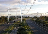
Roe Highway is a limited access dual carriageway in Western Australia
. It links Great Northern Highway
and Middle Swan Road with Kwinana Freeway
. It is one of the key heavy vehicle routes in the Perth
metropolitan area. Aside from intersections, the speed limit is 100 km/h for most of its length. South of Orrong Road and Welshpool Road, the highway is a freeway standard, with no traffic lights and grade separation. The northern half is the standard of Perth's major highways; limited access, with few grade separations and traffic lights.
Roe Highway, together with Reid Highway
, is allocated State Route 3 and is part of National Highway 94
between Great Eastern Highway Bypass
and Great Eastern Highway
, and also part of National Highway 95
between Great Northern Highway
and Great Eastern Highway.
as part of what was to become the Metropolitan Region Planning Scheme. It is named in honour of John Septimus Roe
, first Surveyor General of Western Australia
.
Work began in 1981, with the first section between the Beechboro-Gosnells Highway
and Bushmead Road opening in 1983. The next section, from Bushmead Road to Great Eastern Highway
was opened in 1984. The third stage, linking Great Eastern Highway and Great Northern Highway
opened in 1988, at the same time as the Great Eastern Highway Bypass
opened. The new roads provided a limited access dual carriageway bypass of the historical Guildford
and Midland
districts that was much needed at the time.
In 1994, the highway was extended 2 km further southwards from Tonkin Highway
to Welshpool Road. Following 7 years in hiatus, work recommenced, and in 2001 a new 4 km southwestern extension known as stage 4 was completed from Welshpool Road to the purpose-built Kenwick Link (an Albany Highway
bypass built in 1998) - most of which replaced the overtaxed William Street in Beckenham
. Work on the 3 km long stage 5 was undertaken simultaneously with stage 4, bringing the highway to Nicholson Road in 2002.
Stage 6, a 5 km extension from Nicholson Road to South Street was completed in 2004, with stage 7 being announced shortly afterwards. The 5 km stage 7 extension from South Street to Kwinana Freeway
was completed in 2006, and represents the highway's current southwestern terminus.
The 19km of road built since 1994 between Tonkin Highway and Kwinana Freeway, is to a freeway standard. It may in the future be upgraded to a freeway classification.
towards Fremantle, through South Fremantle along Marine Terrace and then north to connect with Stirling Highway
and the Port of Fremantle. As part of the plan, in 1974 Stirling Highway
was extended from its then terminus north of the Swan River
southwards to Canning Highway
.
A narrow 4 km strip of land immediately south of this intersection was proclaimed for further road construction, but as it was not part of the original Stephenson Plan it was occupied by housing built before the time of Stephenson. Over a period of approximately 20 years, Main Roads Western Australia procured most of the land in question for the future road. In 1985, the first kilometre of this road was constructed, which extended Stirling Highway
southwards from Canning Highway
to Leach Highway (known as High Street west of Carrington Street)
. The remaining 3 km strip of land south of High Street
then became known as the Fremantle Eastern Bypass.
At the southern end of the proposed Fremantle Eastern Bypass, an 8 km east-west road reservation was proclaimed. This became known as Roe Highway stage 8. This land however was lightly built up and much of it remained as urban bushland throughout the late 20th century. The Roe Highway stage 8 reservation was intended to be the final link of a major urban ring-road, as originally envisioned by Stephenson.
However, there were problems with the proposed link, a product of the changes made by governments since Stephenson's original plan. This included the deletion of the original inner Fremantle section and the proclaiming of the Fremantle Eastern Bypass. Some residents of Fremantle
strongly objected to the proposed 4-lane dual carriageway Fremantle Eastern Bypass, claiming it would divide the area, damage urban woodland and impact on 3 nearby schools. Also, the proposed Roe Highway stage 8 would cut between North Lake and Bibra Lake
, a location considered of high environmental value as a wetlands. The Environmental Protection Authority in its report on the proposed Roe Highway Stage 8 confirmed the high conservation status of the Beeliar Wetlands and the negative impacts a highway would have on the wetlands.
With a change of state governments
in 2001, the planned Fremantle Eastern Bypass / Roe Highway stage 8 was cancelled, with a commitment by the government to sell the land reserved for the Fremantle Eastern Bypass. In doing this, the government put forward a '6-point plan' to cope with the anticipated growth of heavy vehicle traffic in and out of the Port of Fremantle, which included plans for better usage of rail, more efficient usage of trucks and a new deepwater container port near Rockingham
. As promised, the Fremantle Eastern Bypass land was sold for a total of $17 million. These funds were then spent on a new grade separated interchange at the intersection of Leach Highway
and Orrong Road in Welshpool
.
During the period for public submissions on the planned cancellation and sell-off, City of Melville residents opposed the planhttp://www.wapc.wa.gov.au/Publications/fig4.pdf?id=466 as the proposed Fremantle Eastern Bypass / Roe Highway stage 8 would have removed most trucks from Leach Highway
, which, although classified as a state highway, travels through a number of residential suburbs. On the other hand the move was generally supported by Fremantle
residents including the local MP, and also those concerned by the potential negative impact the proposed road would have on Bibra Lake wetlands.
As part of the funding arrangement for Roe Highway stages 6 and 7, the federal government
, which provided some of the funding for those two stages, has stipulated that the Roe Highway stage 8 reservation is to be retained.
Following a change in state governments
in September 2008, planning work has now commenced on an extension of the Roe Highway from Kwinana Freeway
to Stock Road http://www.mainroads.wa.gov.au/BuildingRoads/Projects/UrbanProjects/Roe/Pages/roe.aspx. As yet, there is no timeframe for construction.
Western Australia
Western Australia is a state of Australia, occupying the entire western third of the Australian continent. It is bounded by the Indian Ocean to the north and west, the Great Australian Bight and Indian Ocean to the south, the Northern Territory to the north-east and South Australia to the south-east...
. It links Great Northern Highway
Great Northern Highway
The Great Northern Highway is a generally north-south Western Australian highway which links the state's capital Perth with its most northern port, Wyndham. It is in length, with being National Highway...
and Middle Swan Road with Kwinana Freeway
Kwinana Freeway
The Kwinana Freeway is a major arterial road in Perth, Western Australia, linking Perth with the southern suburbs and then further on towards Mandurah, a distance of . It has a speed limit of , except in central Perth and south of Lakes Road . Like all Western Australian freeways, the minimum...
. It is one of the key heavy vehicle routes in the Perth
Perth, Western Australia
Perth is the capital and largest city of the Australian state of Western Australia and the fourth most populous city in Australia. The Perth metropolitan area has an estimated population of almost 1,700,000....
metropolitan area. Aside from intersections, the speed limit is 100 km/h for most of its length. South of Orrong Road and Welshpool Road, the highway is a freeway standard, with no traffic lights and grade separation. The northern half is the standard of Perth's major highways; limited access, with few grade separations and traffic lights.
Roe Highway, together with Reid Highway
Reid Highway
Reid Highway is a major arterial highway in Perth, Western Australia. It is allocated Route 3, and runs between Marmion Avenue, North Beach, and West Swan Road, West Swan, a distance of...
, is allocated State Route 3 and is part of National Highway 94
National Highway (Australia)
thumb|right|150px|The National Highway Shield in NSW, QLD, WA, NT & TAS.The National Highway is a system of roads connecting all the States and Territories of Australia, and is the major network of highways connecting Australia's largest and most important cities.The National Highway was...
between Great Eastern Highway Bypass
Great Eastern Highway Bypass
Great Eastern Highway Bypass is a limited-access dual carriageway linking Great Eastern Highway and Roe Highway in Perth, Western Australia.It was opened on 14 May 1988....
and Great Eastern Highway
Great Eastern Highway
The Great Eastern Highway is a major road between the Western Australian cities of Perth and Kalgoorlie. It is a key route for vehicles accessing the eastern wheatbelt and the eastern goldfields...
, and also part of National Highway 95
National Highway (Australia)
thumb|right|150px|The National Highway Shield in NSW, QLD, WA, NT & TAS.The National Highway is a system of roads connecting all the States and Territories of Australia, and is the major network of highways connecting Australia's largest and most important cities.The National Highway was...
between Great Northern Highway
Great Northern Highway
The Great Northern Highway is a generally north-south Western Australian highway which links the state's capital Perth with its most northern port, Wyndham. It is in length, with being National Highway...
and Great Eastern Highway.
History
Roe Highway was first proposed in 1955 by Gordon StephensonGordon Stephenson
Gordon Stephenson was a British-born town planner and architect. He is best known for his role in shaping the modern growth and development of Perth, Western Australia.-Early career:...
as part of what was to become the Metropolitan Region Planning Scheme. It is named in honour of John Septimus Roe
John Septimus Roe
John Septimus Roe was the first Surveyor-General of Western Australia. He was a renowned explorer, and a Member of Western Australia's Legislative and Executive Councils for nearly 40 years.-Early life:...
, first Surveyor General of Western Australia
Surveyor General of Western Australia
The Surveyor General of Western Australia is the person nominally responsible for government surveying in Western Australia.In the early history of Western Australia, the office of surveyor general was one of the most important public offices...
.
Work began in 1981, with the first section between the Beechboro-Gosnells Highway
Tonkin Highway
Tonkin Highway, at , is a limited access dual carriageway in Perth, Western Australia, connecting Reid Highway in the north with Thomas Road in the south. Mostly a 4 lane highway, some sections of the highway are to a 4 to 6 lane freeway standard; the remainder of the highway has been designed to...
and Bushmead Road opening in 1983. The next section, from Bushmead Road to Great Eastern Highway
Great Eastern Highway
The Great Eastern Highway is a major road between the Western Australian cities of Perth and Kalgoorlie. It is a key route for vehicles accessing the eastern wheatbelt and the eastern goldfields...
was opened in 1984. The third stage, linking Great Eastern Highway and Great Northern Highway
Great Northern Highway
The Great Northern Highway is a generally north-south Western Australian highway which links the state's capital Perth with its most northern port, Wyndham. It is in length, with being National Highway...
opened in 1988, at the same time as the Great Eastern Highway Bypass
Great Eastern Highway Bypass
Great Eastern Highway Bypass is a limited-access dual carriageway linking Great Eastern Highway and Roe Highway in Perth, Western Australia.It was opened on 14 May 1988....
opened. The new roads provided a limited access dual carriageway bypass of the historical Guildford
Guildford, Western Australia
Guildford is a suburb of Perth, Western Australia, located 13 km northeast of the city. Its Local Government Area is the City of Swan.-History:Guildford was established in 1829 on the Swan River, being sited near a permanent fresh water supply...
and Midland
Midland, Western Australia
Midland is a suburb in the Perth, Western Australia metropolitan area, as well as the regional centre for the City of Swan local government area that covers the Swan Valley and parts of the Darling Scarp to the east. It is situated at the intersection of Great Eastern Highway and Great Northern...
districts that was much needed at the time.
In 1994, the highway was extended 2 km further southwards from Tonkin Highway
Tonkin Highway
Tonkin Highway, at , is a limited access dual carriageway in Perth, Western Australia, connecting Reid Highway in the north with Thomas Road in the south. Mostly a 4 lane highway, some sections of the highway are to a 4 to 6 lane freeway standard; the remainder of the highway has been designed to...
to Welshpool Road. Following 7 years in hiatus, work recommenced, and in 2001 a new 4 km southwestern extension known as stage 4 was completed from Welshpool Road to the purpose-built Kenwick Link (an Albany Highway
Albany Highway
Albany Highway is a generally northwest-southeast highway in the south of Western Australia which links the state's capital Perth with its oldest settlement, Albany. The highway is approximately in length, is designated State Route 30 and separates Western Australia's Great Southern region from...
bypass built in 1998) - most of which replaced the overtaxed William Street in Beckenham
Beckenham, Western Australia
Beckenham is a suburb of Perth, Western Australia, located within the City of Gosnells.-History:This suburb has seen many name changes. It was most recently known as Buckingham, it once shared a "common usage" name of Waverley with East Cannington, and has one of the oldest primary schools in...
. Work on the 3 km long stage 5 was undertaken simultaneously with stage 4, bringing the highway to Nicholson Road in 2002.
Stage 6, a 5 km extension from Nicholson Road to South Street was completed in 2004, with stage 7 being announced shortly afterwards. The 5 km stage 7 extension from South Street to Kwinana Freeway
Kwinana Freeway
The Kwinana Freeway is a major arterial road in Perth, Western Australia, linking Perth with the southern suburbs and then further on towards Mandurah, a distance of . It has a speed limit of , except in central Perth and south of Lakes Road . Like all Western Australian freeways, the minimum...
was completed in 2006, and represents the highway's current southwestern terminus.
The 19km of road built since 1994 between Tonkin Highway and Kwinana Freeway, is to a freeway standard. It may in the future be upgraded to a freeway classification.
Stage 8 / the Fremantle Eastern Bypass
In the 1950s, Stephenson planned for Roe Highway to continue westwards from its present terminus at Kwinana FreewayKwinana Freeway
The Kwinana Freeway is a major arterial road in Perth, Western Australia, linking Perth with the southern suburbs and then further on towards Mandurah, a distance of . It has a speed limit of , except in central Perth and south of Lakes Road . Like all Western Australian freeways, the minimum...
towards Fremantle, through South Fremantle along Marine Terrace and then north to connect with Stirling Highway
Stirling Highway
Stirling Highway is, for most of its length, a four-lane single carriageway and major arterial road between Perth, Western Australia and the port city of Fremantle in Western Australia on the northern side of the Swan River. The speed limit is 60 km/h...
and the Port of Fremantle. As part of the plan, in 1974 Stirling Highway
Stirling Highway
Stirling Highway is, for most of its length, a four-lane single carriageway and major arterial road between Perth, Western Australia and the port city of Fremantle in Western Australia on the northern side of the Swan River. The speed limit is 60 km/h...
was extended from its then terminus north of the Swan River
Swan River (Western Australia)
The Swan River estuary flows through the city of Perth, in the south west of Western Australia. Its lower reaches are relatively wide and deep, with few constrictions, while the upper reaches are usually quite narrow and shallow....
southwards to Canning Highway
Canning Highway
Canning Highway is a mostly 4 lane single carriageway major arterial road in Perth, Western Australia. The speed limit is 60 km/h. It is located south of the Swan River and links Perth with Fremantle, running between The Causeway in Victoria Park and Queen Victoria Street in...
.
A narrow 4 km strip of land immediately south of this intersection was proclaimed for further road construction, but as it was not part of the original Stephenson Plan it was occupied by housing built before the time of Stephenson. Over a period of approximately 20 years, Main Roads Western Australia procured most of the land in question for the future road. In 1985, the first kilometre of this road was constructed, which extended Stirling Highway
Stirling Highway
Stirling Highway is, for most of its length, a four-lane single carriageway and major arterial road between Perth, Western Australia and the port city of Fremantle in Western Australia on the northern side of the Swan River. The speed limit is 60 km/h...
southwards from Canning Highway
Canning Highway
Canning Highway is a mostly 4 lane single carriageway major arterial road in Perth, Western Australia. The speed limit is 60 km/h. It is located south of the Swan River and links Perth with Fremantle, running between The Causeway in Victoria Park and Queen Victoria Street in...
to Leach Highway (known as High Street west of Carrington Street)
Leach Highway
Leach Highway is a major dual carriageway arterial road in Perth, Western Australia, which varies between 4 and 6 lanes wide. The speed limit is either 70 or 80 km/h. It is located south of the Swan River and links Fremantle with Kewdale, a distance of ....
. The remaining 3 km strip of land south of High Street
Leach Highway
Leach Highway is a major dual carriageway arterial road in Perth, Western Australia, which varies between 4 and 6 lanes wide. The speed limit is either 70 or 80 km/h. It is located south of the Swan River and links Fremantle with Kewdale, a distance of ....
then became known as the Fremantle Eastern Bypass.
At the southern end of the proposed Fremantle Eastern Bypass, an 8 km east-west road reservation was proclaimed. This became known as Roe Highway stage 8. This land however was lightly built up and much of it remained as urban bushland throughout the late 20th century. The Roe Highway stage 8 reservation was intended to be the final link of a major urban ring-road, as originally envisioned by Stephenson.
However, there were problems with the proposed link, a product of the changes made by governments since Stephenson's original plan. This included the deletion of the original inner Fremantle section and the proclaiming of the Fremantle Eastern Bypass. Some residents of Fremantle
Fremantle, Western Australia
Fremantle is a city in Western Australia, located at the mouth of the Swan River. Fremantle Harbour serves as the port of Perth, the state capital. Fremantle was the first area settled by the Swan River colonists in 1829...
strongly objected to the proposed 4-lane dual carriageway Fremantle Eastern Bypass, claiming it would divide the area, damage urban woodland and impact on 3 nearby schools. Also, the proposed Roe Highway stage 8 would cut between North Lake and Bibra Lake
Bibra Lake, Western Australia
-Facilities:The majority of the suburb, which is not part of the Beeliar Regional Park contains a major light industrial area, with businesses such as Amcor....
, a location considered of high environmental value as a wetlands. The Environmental Protection Authority in its report on the proposed Roe Highway Stage 8 confirmed the high conservation status of the Beeliar Wetlands and the negative impacts a highway would have on the wetlands.
With a change of state governments
Government of Western Australia
The formation of the Government of Western Australia is prescribed in its Constitution, which dates from 1890, although it has been amended many times since then...
in 2001, the planned Fremantle Eastern Bypass / Roe Highway stage 8 was cancelled, with a commitment by the government to sell the land reserved for the Fremantle Eastern Bypass. In doing this, the government put forward a '6-point plan' to cope with the anticipated growth of heavy vehicle traffic in and out of the Port of Fremantle, which included plans for better usage of rail, more efficient usage of trucks and a new deepwater container port near Rockingham
Rockingham, Western Australia
Rockingham is a suburb and primary centre in Western Australia south-west of the Perth city centre and south of Fremantle. It has a beachside location at Mangles Bay, the southern extremity of Cockburn Sound. To its north stretches the maritime and resource-industry installations of Kwinana and...
. As promised, the Fremantle Eastern Bypass land was sold for a total of $17 million. These funds were then spent on a new grade separated interchange at the intersection of Leach Highway
Leach Highway
Leach Highway is a major dual carriageway arterial road in Perth, Western Australia, which varies between 4 and 6 lanes wide. The speed limit is either 70 or 80 km/h. It is located south of the Swan River and links Fremantle with Kewdale, a distance of ....
and Orrong Road in Welshpool
Welshpool, Western Australia
Welshpool is an inner southeastern suburb of Perth, located mostly within the City of Canning. The area is considered to be one of the main industrial areas of Perth, along with Kewdale, Kwinana, Henderson, Malaga, O'Connor, Canning Vale and Osborne Park....
.
During the period for public submissions on the planned cancellation and sell-off, City of Melville residents opposed the planhttp://www.wapc.wa.gov.au/Publications/fig4.pdf?id=466 as the proposed Fremantle Eastern Bypass / Roe Highway stage 8 would have removed most trucks from Leach Highway
Leach Highway
Leach Highway is a major dual carriageway arterial road in Perth, Western Australia, which varies between 4 and 6 lanes wide. The speed limit is either 70 or 80 km/h. It is located south of the Swan River and links Fremantle with Kewdale, a distance of ....
, which, although classified as a state highway, travels through a number of residential suburbs. On the other hand the move was generally supported by Fremantle
Fremantle, Western Australia
Fremantle is a city in Western Australia, located at the mouth of the Swan River. Fremantle Harbour serves as the port of Perth, the state capital. Fremantle was the first area settled by the Swan River colonists in 1829...
residents including the local MP, and also those concerned by the potential negative impact the proposed road would have on Bibra Lake wetlands.
As part of the funding arrangement for Roe Highway stages 6 and 7, the federal government
Government of Australia
The Commonwealth of Australia is a federal constitutional monarchy under a parliamentary democracy. The Commonwealth of Australia was formed in 1901 as a result of an agreement among six self-governing British colonies, which became the six states...
, which provided some of the funding for those two stages, has stipulated that the Roe Highway stage 8 reservation is to be retained.
Following a change in state governments
Government of Western Australia
The formation of the Government of Western Australia is prescribed in its Constitution, which dates from 1890, although it has been amended many times since then...
in September 2008, planning work has now commenced on an extension of the Roe Highway from Kwinana Freeway
Kwinana Freeway
The Kwinana Freeway is a major arterial road in Perth, Western Australia, linking Perth with the southern suburbs and then further on towards Mandurah, a distance of . It has a speed limit of , except in central Perth and south of Lakes Road . Like all Western Australian freeways, the minimum...
to Stock Road http://www.mainroads.wa.gov.au/BuildingRoads/Projects/UrbanProjects/Roe/Pages/roe.aspx. As yet, there is no timeframe for construction.
Junctions
| Allocated | Allocation | Junction | Suburb |
|---|---|---|---|
  |
   |
Great Northern Highway Great Northern Highway The Great Northern Highway is a generally north-south Western Australian highway which links the state's capital Perth with its most northern port, Wyndham. It is in length, with being National Highway... |
Middle Swan Middle Swan, Western Australia Middle Swan is a rural suburb of Perth, Western Australia in the Swan Valley, and forms part of the City of Swan local government area. The suburb is bisected by the Swan River... |
 |
Toodyay Road Toodyay Road Toodyay Road is a mostly 2-lane undivided single carriageway in Western Australia, running from the north-eastern Perth suburb of Middle Swan, through Gidgegannup and Bailup, to the Wheatbelt town of Toodyay... |
Middle Swan Middle Swan, Western Australia Middle Swan is a rural suburb of Perth, Western Australia in the Swan Valley, and forms part of the City of Swan local government area. The suburb is bisected by the Swan River... & Stratton Stratton, Western Australia Stratton is a mostly residential eastern suburb of Perth, Western Australia, located within the City of Swan. Formerly known as Wexcombe, the name Stratton was chosen in 1989 to honour John Peter Stratton, a farmer, businessman and local landowner who was president of the Western Australian... |
|
| Morrison Road Morrison Road Morrison Road is a major road which runs through the suburbs of Woodbridge, Midland, Midvale and Swan View, in the east of Perth, Western Australia.... |
Midvale Midvale, Western Australia Midvale is a suburb of Perth, Western Australia, located mostly within the City of Swan, and partly within the Shire of Mundaring. Its postcode is 6056.... |
||
   |
Great Eastern Highway Great Eastern Highway The Great Eastern Highway is a major road between the Western Australian cities of Perth and Kalgoorlie. It is a key route for vehicles accessing the eastern wheatbelt and the eastern goldfields... |
Bellevue Bellevue, Western Australia Bellevue is an eastern suburb of Perth, Western Australia. Its Local Government Areas are the City of Swan and the Shire of Mundaring, and it is located at the foot of the slopes of Greenmount, a landmark on the Darling Scarp that is noted in the earliest of travel journals of the early Swan River... & Midvale Midvale, Western Australia Midvale is a suburb of Perth, Western Australia, located mostly within the City of Swan, and partly within the Shire of Mundaring. Its postcode is 6056.... |
|
| Allocated | Allocation | Junction | Suburb |
| |
Clayton Street | Bellevue Bellevue, Western Australia Bellevue is an eastern suburb of Perth, Western Australia. Its Local Government Areas are the City of Swan and the Shire of Mundaring, and it is located at the foot of the slopes of Greenmount, a landmark on the Darling Scarp that is noted in the earliest of travel journals of the early Swan River... |
|
| |
Great Eastern Highway Bypass Great Eastern Highway Bypass Great Eastern Highway Bypass is a limited-access dual carriageway linking Great Eastern Highway and Roe Highway in Perth, Western Australia.It was opened on 14 May 1988.... |
Hazelmere Hazelmere, Western Australia Hazelmere is a suburb of Perth, Western Australia. Bordered by Roe Highway to the east, and the Great Eastern Highway Bypass to the south, Hazelmere is located at the northern edge of Perth Airport land.It is in the City of Swan local government area.... |
|
| Allocated | Allocation | Junction | Suburb |
| |
 |
Kalamunda Road Kalamunda Road Kalamunda Road is a minor arterial road linking the historic suburb of South Guildford with the Darling Scarp town of Kalamunda, in Perth, Western Australia.... |
High Wycombe High Wycombe, Western Australia High Wycombe is a suburb of Perth, Western Australia, located within the Shire of Kalamunda. High Wycombe lies east of the Perth CBD at the base of the Darling Scarp .... & Maida Vale Maida Vale, Western Australia Maida Vale is a suburb of Perth, Western Australia, located within the Shire of Kalamunda. Kalamunda Road runs through the suburb.Within the suburb there is a primary school , a golf course, numerous parks/ovals , small shops including a BP Petrol station and a heated swimming pool... |
| Maida Vale Road | High Wycombe High Wycombe, Western Australia High Wycombe is a suburb of Perth, Western Australia, located within the Shire of Kalamunda. High Wycombe lies east of the Perth CBD at the base of the Darling Scarp .... & Maida Vale Maida Vale, Western Australia Maida Vale is a suburb of Perth, Western Australia, located within the Shire of Kalamunda. Kalamunda Road runs through the suburb.Within the suburb there is a primary school , a golf course, numerous parks/ovals , small shops including a BP Petrol station and a heated swimming pool... |
||
| Berkshire Road | Forrestfield Forrestfield, Western Australia Forrestfield is a suburb of the Shire of Kalamunda in Western Australia. It lies 15 km to the southeast of Perth at the base of the Darling Scarp and the Southern border of the International Airport. There is authority to suggest it is named after Western Australia's first premier, John Forrest... |
||
 |
Tonkin Highway Tonkin Highway Tonkin Highway, at , is a limited access dual carriageway in Perth, Western Australia, connecting Reid Highway in the north with Thomas Road in the south. Mostly a 4 lane highway, some sections of the highway are to a 4 to 6 lane freeway standard; the remainder of the highway has been designed to... |
Forrestfield Forrestfield, Western Australia Forrestfield is a suburb of the Shire of Kalamunda in Western Australia. It lies 15 km to the southeast of Perth at the base of the Darling Scarp and the Southern border of the International Airport. There is authority to suggest it is named after Western Australia's first premier, John Forrest... & Welshpool Welshpool, Western Australia Welshpool is an inner southeastern suburb of Perth, located mostly within the City of Canning. The area is considered to be one of the main industrial areas of Perth, along with Kewdale, Kwinana, Henderson, Malaga, O'Connor, Canning Vale and Osborne Park.... |
|
| Chrisholm Crescent | Welshpool Welshpool, Western Australia Welshpool is an inner southeastern suburb of Perth, located mostly within the City of Canning. The area is considered to be one of the main industrial areas of Perth, along with Kewdale, Kwinana, Henderson, Malaga, O'Connor, Canning Vale and Osborne Park.... |
||
 |
Orrong Road/Welshpool Road Welshpool Road, Perth Welshpool Road is a major arterial road running through the metropolitan area of Perth, Western Australia. Although the road is now split in two, having had its West and East sections disconnected due to the extension of Roe Highway, it remains Welshpool's second most important road , and the... |
Welshpool Welshpool, Western Australia Welshpool is an inner southeastern suburb of Perth, located mostly within the City of Canning. The area is considered to be one of the main industrial areas of Perth, along with Kewdale, Kwinana, Henderson, Malaga, O'Connor, Canning Vale and Osborne Park.... & East Cannington East Cannington, Western Australia East Cannington is a southeastern suburb of Perth, Western Australia. Its Local Government Area is the City of Canning.-History:East Cannington, previously part of Queens Park Road Board District, and once incorporating present day Beckenham was largely a semi-rural area, with only the area near... |
|
 |
Kenwick Link | Kenwick Kenwick, Western Australia Kenwick, Western Australia is a mixed residential, light industrial and semi-rural suburb located in the south-east of Perth, Western Australia, located within the City of Gosnells... & Beckenham Beckenham, Western Australia Beckenham is a suburb of Perth, Western Australia, located within the City of Gosnells.-History:This suburb has seen many name changes. It was most recently known as Buckingham, it once shared a "common usage" name of Waverley with East Cannington, and has one of the oldest primary schools in... |
|
 |
Nicholson Road | Lynwood Parkwood, Western Australia Parkwood is a southeastern suburb of Perth, Western Australia. Its Local Government Area is the City of Canning.-History:Parkwood was first settled by Henry Willett of Willett & Co, who was granted Canning Location 21 on the Canning River and settled in the area in June 1832... , Langford Langford, Western Australia Langford is a suburb of Perth, Western Australia, located within the City of Gosnells. Its postcode is 6147.Langford is a working-class residential suburb located approximately 11 km from Perth's central business district. Recently the suburb has been upgraded and redeveloped, especially since... , Thornlie Thornlie, Western Australia Thornlie is a large outer suburb of Perth, Western Australia, located 18 kilometres south-east of Perth's central business district. It is part of the City of Gosnells local government area. The Canning River runs through the northern side of the suburb... & Canning Vale Canning Vale, Western Australia Canning Vale is a large southern suburb of Perth, and is located 20 km from the Perth CBD. Its Local Government Areas are the City of Canning and the City of Gosnells .-History:... |
|
| Willeri Drive | Parkwood Parkwood, Western Australia Parkwood is a southeastern suburb of Perth, Western Australia. Its Local Government Area is the City of Canning.-History:Parkwood was first settled by Henry Willett of Willett & Co, who was granted Canning Location 21 on the Canning River and settled in the area in June 1832... & Willetton Willetton, Western Australia Willetton is a large southern suburb of Perth, Western Australia. Its Local Government Area is the City of Canning.-History:Willetton's name derives from Henry Willett of Willett & Co, who was granted Canning Location 21 and settled in the area in June 1832... |
||
 |
South Street | Willetton Willetton, Western Australia Willetton is a large southern suburb of Perth, Western Australia. Its Local Government Area is the City of Canning.-History:Willetton's name derives from Henry Willett of Willett & Co, who was granted Canning Location 21 and settled in the area in June 1832... & Leeming Leeming, Western Australia Leeming is a southern suburb of Perth, Western Australia. It is divided between the tree Local Government Areas of the City of Melville, the City of Cockburn and the City of Canning... |
|
| Karel Avenue | Leeming Leeming, Western Australia Leeming is a southern suburb of Perth, Western Australia. It is divided between the tree Local Government Areas of the City of Melville, the City of Cockburn and the City of Canning... & Jandakot |
||
 |
Kwinana Freeway Kwinana Freeway The Kwinana Freeway is a major arterial road in Perth, Western Australia, linking Perth with the southern suburbs and then further on towards Mandurah, a distance of . It has a speed limit of , except in central Perth and south of Lakes Road . Like all Western Australian freeways, the minimum... |
North Lake North Lake, Western Australia North Lake is a suburb south of the central business district of Perth, the capital of Western Australia, and from the Indian Ocean. The suburb is located within the City of Cockburn local government area.-History:... & Jandakot |
See also
- Highways in AustraliaHighways in AustraliaThis is a list of highways in Australia, listed alphabetically along with each highway's route number and location. Note that some highways service more than one state or territory.-Route numbering systems:...
- Highways in Western Australia
- Freeways in AustraliaFreeways in AustraliaThis is a list of freeways and motorways in Australia, sorted by states and territories and their corresponding routes. This list includes toll roads such as the CityLink freeway system in Melbourne. This list has over 70 entries...
- Freeways in Western Australia