
Transantarctic Mountains
Encyclopedia
East Antarctica Ranges
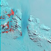
The East Antarctica Ranges are one of the three largest mountain ranges in Antarctica, the others are the Transantarctic Mountains and West Antarctica Ranges. The East Antarctica Ranges, located on the East Antarctic Ice Sheet, have 29 known peaks whose summits reach or exceed 2000 meters above sea...
. The Transantarctic Mountains compose a mountain range
Mountain range
A mountain range is a single, large mass consisting of a succession of mountains or narrowly spaced mountain ridges, with or without peaks, closely related in position, direction, formation, and age; a component part of a mountain system or of a mountain chain...
in Antarctica which extend, with some interruptions, across the continent from Cape Adare
Cape Adare
Cape Adare is the northeastern most peninsula in Victoria Land, East Antarctica. The cape separates the Ross Sea to the east from the Southern Ocean to the west, and is backed by the high Admiralty Mountains...
in northern Victoria Land
Victoria Land
Victoria Land is a region of Antarctica bounded on the east by the Ross Ice Shelf and the Ross Sea and on the west by Oates Land and Wilkes Land. It was discovered by Captain James Clark Ross in January 1841 and named after the UK's Queen Victoria...
to Coats Land
Coats Land
Coats Land is a region in Antarctica which lies westward of Queen Maud Land and forms the eastern shore of the Weddell Sea, extending in a general northeast-southwest direction between 20º00´W and 36º00´W. The northeast part was discovered from the Scotia by William S. Bruce, leader of the Scottish...
. These mountains serve as the division between East Antarctica
East Antarctica
East Antarctica, also called Greater Antarctica, constitutes the majority of the Antarctic continent, lying on the Indian Ocean side of the Transantarctic Mountains...
and West Antarctica
West Antarctica
West Antarctica, or Lesser Antarctica, one of the two major regions of Antarctica, is the part of the continent that lies within the Western Hemisphere including the Antarctic Peninsula.-Location and description:...
. They include a number of separately named mountain groups, which are often again subdivided into smaller ranges.
Geography
The mountain range stretches between the Ross SeaRoss Sea
The Ross Sea is a deep bay of the Southern Ocean in Antarctica between Victoria Land and Marie Byrd Land.-Description:The Ross Sea was discovered by James Ross in 1841. In the west of the Ross Sea is Ross Island with the Mt. Erebus volcano, in the east Roosevelt Island. The southern part is covered...
and the Weddell Sea
Weddell Sea
The Weddell Sea is part of the Southern Ocean and contains the Weddell Gyre. Its land boundaries are defined by the bay formed from the coasts of Coats Land and the Antarctic Peninsula. The easternmost point is Cape Norvegia at Princess Martha Coast, Queen Maud Land. To the east of Cape Norvegia is...
the entire length of Antarctica, hence the name. With a total length of about 3,500 km, the Transantarctic Mountains are one of the longest mountain ranges on Earth
Earth
Earth is the third planet from the Sun, and the densest and fifth-largest of the eight planets in the Solar System. It is also the largest of the Solar System's four terrestrial planets...
. The 100–300 km wide range forms the boundary between East Antarctica
East Antarctica
East Antarctica, also called Greater Antarctica, constitutes the majority of the Antarctic continent, lying on the Indian Ocean side of the Transantarctic Mountains...
and West Antarctica
West Antarctica
West Antarctica, or Lesser Antarctica, one of the two major regions of Antarctica, is the part of the continent that lies within the Western Hemisphere including the Antarctic Peninsula.-Location and description:...
. The East Antarctic Ice Sheet
East Antarctic Ice Sheet
The East Antarctic Ice Sheet is one of two large ice sheets in Antarctica, and the largest on the entire planet. The EAIS lies between 45° West and 168° East longitudinally....
bounds the TAM along their entire length on the Eastern Hemisphere
Eastern Hemisphere
The Eastern Hemisphere, also Eastern hemisphere or eastern hemisphere, is a geographical term for the half of the Earth that is east of the Prime Meridian and west of 180° longitude. It is also used to refer to Europe, Asia, Africa, and Australasia, vis-à-vis the Western Hemisphere, which includes...
side, while the Western Hemisphere
Western Hemisphere
The Western Hemisphere or western hemisphere is mainly used as a geographical term for the half of the Earth that lies west of the Prime Meridian and east of the Antimeridian , the other half being called the Eastern Hemisphere.In this sense, the western hemisphere consists of the western portions...
side of the range is bounded by the Ross Sea
Ross Sea
The Ross Sea is a deep bay of the Southern Ocean in Antarctica between Victoria Land and Marie Byrd Land.-Description:The Ross Sea was discovered by James Ross in 1841. In the west of the Ross Sea is Ross Island with the Mt. Erebus volcano, in the east Roosevelt Island. The southern part is covered...
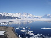
(C.Michael Hogan. 2011) in Victoria Land from Cape Adare to McMurdo Sound
McMurdo Sound
The ice-clogged waters of Antarctica's McMurdo Sound extend about 55 km long and wide. The sound opens into the Ross Sea to the north. The Royal Society Range rises from sea level to 13,205 feet on the western shoreline. The nearby McMurdo Ice Shelf scribes McMurdo Sound's southern boundary...
, the Ross Ice Shelf
Ross Ice Shelf
The Ross Ice Shelf is the largest ice shelf of Antarctica . It is several hundred metres thick. The nearly vertical ice front to the open sea is more than 600 km long, and between 15 and 50 metres high above the water surface...
from McMurdo Sound to near the Scott Glacier
Scott Glacier (Transantarctic Mountains)
The Scott Glacier is a major glacier, 120 miles long, that drains the East Antarctic Ice Sheet through the Queen Maud Mountains to the Ross Ice Shelf...
, and the West Antarctic Ice Sheet
West Antarctic Ice Sheet
The West Antarctic Ice Sheet is the segment of the continental ice sheet that covers West Antarctica, the portion of Antarctica on the side of the Transantarctic Mountains which lies in the Western Hemisphere. The WAIS is classified as a marine-based ice sheet, meaning that its bed lies well...
beyond.
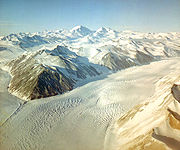
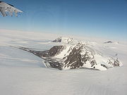
The summits
Summit (topography)
In topography, a summit is a point on a surface that is higher in elevation than all points immediately adjacent to it. Mathematically, a summit is a local maximum in elevation...
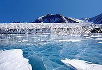
and dry valleys of the TAM are some of the few places in Antarctica not covered by ice, the highest of which rise more than 4500 metres (14,763.8 ft) above sea level. The Dry Valleys
McMurdo Dry Valleys
The McMurdo Dry Valleys are a row of snow-free valleys in Antarctica located within Victoria Land west of McMurdo Sound. The region is one of the world's most extreme deserts, and includes many interesting features including Lake Vida and the Onyx River, Antarctica's longest river.-Climate:The Dry...
lie near McMurdo Sound and represent a special Antarctic phenomenon: landscapes that are snow and ice free due to the extremely limited precipitation
Precipitation (meteorology)
In meteorology, precipitation In meteorology, precipitation In meteorology, precipitation (also known as one of the classes of hydrometeors, which are atmospheric water phenomena is any product of the condensation of atmospheric water vapor that falls under gravity. The main forms of precipitation...
and ablation
Ablation
Ablation is removal of material from the surface of an object by vaporization, chipping, or other erosive processes. This occurs in spaceflight during ascent and atmospheric reentry, glaciology, medicine, and passive fire protection.-Spaceflight:...
of ice in the valleys. The highest mountain of the TAM is 4,528 m high Mount Kirkpatrick
Mount Kirkpatrick
Mount Kirkpatrick is a lofty, generally ice-free mountain in Antarctica's Queen Alexandra Range. Located 8 km west of Mount Dickerson, Mt. Kirkpatrick is the highest point in the Queen Alexandra Range, as well as in its parent range, the Transantarctic Mountains...
in the Queen Alexandra Range
Queen Alexandra Range
The Queen Alexandra Range is a major mountain range in East Antarctica, about 160 km long, bordering the entire western side of Beardmore Glacier from the Polar Plateau to the Ross Ice Shelf. Alternate names for this range include Alexandra Mountains, Alexandra Range and Königin Alexandra...
. Isolated peaks surrounded by ice are referred to as nunatak
Nunatak
A nunatak is an exposed, often rocky element of a ridge, mountain, or peak not covered with ice or snow within an ice field or glacier. The term is typically used in areas where a permanent ice sheet is present...
s.
Biology
PenguinPenguin
Penguins are a group of aquatic, flightless birds living almost exclusively in the southern hemisphere, especially in Antarctica. Highly adapted for life in the water, penguins have countershaded dark and white plumage, and their wings have become flippers...
s, seals
Earless seal
The true seals or earless seals are one of the three main groups of mammals within the seal superfamily, Pinnipedia. All true seals are members of the family Phocidae . They are sometimes called crawling seals to distinguish them from the fur seals and sea lions of the family Otariidae...
, and sea birds live along the Ross Sea coastline in Victoria Land, while life in the interior of the Transantarctics is limited to lichens, algae
Algae
Algae are a large and diverse group of simple, typically autotrophic organisms, ranging from unicellular to multicellular forms, such as the giant kelps that grow to 65 meters in length. They are photosynthetic like plants, and "simple" because their tissues are not organized into the many...
, and fungi.
History
The Transantarctic Mountains were first seen by Captain James RossJames Clark Ross
Sir James Clark Ross , was a British naval officer and explorer. He explored the Arctic with his uncle Sir John Ross and Sir William Parry, and later led his own expedition to Antarctica.-Arctic explorer:...
in 1841 from the Ross Sea. The range is a natural barrier that must be crossed to reach the South Pole
South Pole
The South Pole, also known as the Geographic South Pole or Terrestrial South Pole, is one of the two points where the Earth's axis of rotation intersects its surface. It is the southernmost point on the surface of the Earth and lies on the opposite side of the Earth from the North Pole...
from the Ross Ice Shelf
Ross Ice Shelf
The Ross Ice Shelf is the largest ice shelf of Antarctica . It is several hundred metres thick. The nearly vertical ice front to the open sea is more than 600 km long, and between 15 and 50 metres high above the water surface...
. In 1908, while not making the pole, Ernest Shackleton
Ernest Shackleton
Sir Ernest Henry Shackleton, CVO, OBE was a notable explorer from County Kildare, Ireland, who was one of the principal figures of the period known as the Heroic Age of Antarctic Exploration...
's party was the first to cross the mountains, using the Beardmore Glacier
Beardmore Glacier
The Beardmore Glacier in Antarctica is one of the largest glaciers in the world, with a length exceeding 160 km . The glacier is one of the main passages from the Ross Ice Shelf through the Queen Alexandra and Commonwealth ranges of the Transantarctic Mountains to the Antarctic Plateau, and was one...
. Robert Scott
Robert Falcon Scott
Captain Robert Falcon Scott, CVO was a Royal Navy officer and explorer who led two expeditions to the Antarctic regions: the Discovery Expedition, 1901–04, and the ill-fated Terra Nova Expedition, 1910–13...
returned to the Beardmore in 1911, while Roald Amundsen
Roald Amundsen
Roald Engelbregt Gravning Amundsen was a Norwegian explorer of polar regions. He led the first Antarctic expedition to reach the South Pole between 1910 and 1912 and he was the first person to reach both the North and South Poles. He is also known as the first to traverse the Northwest Passage....
crossed the range via the Axel Heiberg Glacier
Axel Heiberg Glacier
The Axel Heiberg Glacier is a valley glacier, long, descending from the high-elevations of the Antarctic Plateau into the Ross Ice Shelf between the Herbert Range and Mount Don Pedro Christophersen in the Queen Maud Mountains....
.
Much of the range remained unexplored until the late 1940s and 1950s, when missions such as Operation Highjump
Operation Highjump
Operation Highjump , officially titled The United States Navy Antarctic Developments Program, 1946-1947, was a United States Navy operation organized by RADM Richard E. Byrd Jr. USN, , Officer in Charge, Task Force 68, and led by RADM Richard H. Cruzen, USN, Commanding Officer, Task Force 68....
and the International Geophysical Year
International Geophysical Year
The International Geophysical Year was an international scientific project that lasted from July 1, 1957, to December 31, 1958. It marked the end of a long period during the Cold War when scientific interchange between East and West was seriously interrupted...
made extensive use of aerial photography
Aerial photography
Aerial photography is the taking of photographs of the ground from an elevated position. The term usually refers to images in which the camera is not supported by a ground-based structure. Cameras may be hand held or mounted, and photographs may be taken by a photographer, triggered remotely or...
and concentrated on a thorough investigation of the entire continent. The name "Transantarctic Mountains" were recommended in 1962 by the US-ACAN committee
Advisory Committee on Antarctic Names
The Advisory Committee on Antarctic Names is an advisory committee of the United States Board on Geographic Names responsible for recommending names for features in Antarctica...
, a US authority for geographic names. This purely descriptive label (in contrast to many other geographic names of the seventh continent) is internationally accepted at present.
The Leverett Glacier
Leverett Glacier
Leverett Glacier in Antarctica is about 80 km long and 4 to 6 km wide, draining northward from the Watson Escarpment, between the California and Stanford Plateaus, and then trending WNW between the Tapley Mountains and Harold Byrd Mountains to terminate at the head of the Ross Ice Shelf...
in the Queen Maud Mountains
Queen Maud Mountains
The Queen Maud Mountains are a major group of mountains, ranges and subordinate features of the Transantarctic Mountains, lying between the Beardmore and Reedy Glaciers and including the area from the head of the Ross Ice Shelf to the polar plateau in Antarctica...
is the planned route through the TAM for the overland supply road
McMurdo-South Pole highway
The South Pole Traverse, also called the McMurdo – South Pole Highway, is an approximately 900-mile compacted snow road in Antarctica that links the United States' McMurdo Station on the coast to the Amundsen–Scott South Pole Station...
between McMurdo Station
McMurdo Station
McMurdo Station is a U.S. Antarctic research center located on the southern tip of Ross Island, which is in the New Zealand-claimed Ross Dependency on the shore of McMurdo Sound in Antarctica. It is operated by the United States through the United States Antarctic Program, a branch of the National...
and Amundsen-Scott South Pole Station
Amundsen-Scott South Pole Station
The Amundsen–Scott South Pole Station is the American scientific research station on the high plateau of Antarctica. This station is located at the southernmost place on the Earth, the Geographic South Pole, at an elevation of 2,835 meters above sea level.The original Amundsen-Scott Station was...
.
Geology
The Transantarctic Mountains are considerably older than other mountain ranges of the continent that are mainly volcanicVolcano
2. Bedrock3. Conduit 4. Base5. Sill6. Dike7. Layers of ash emitted by the volcano8. Flank| 9. Layers of lava emitted by the volcano10. Throat11. Parasitic cone12. Lava flow13. Vent14. Crater15...
in origin. The range was uplift
Tectonic uplift
Tectonic uplift is a geological process most often caused by plate tectonics which increases elevation. The opposite of uplift is subsidence, which results in a decrease in elevation. Uplift may be orogenic or isostatic.-Orogenic uplift:...
ed during the opening of the West Antarctic Rift
West Antarctic Rift
The West Antarctic Rift is a major, active rift valley lying between East and West Antarctica. It encompasses the Ross Sea, the area under the Ross Ice Shelf and a part of West Antarctica...
to the east, beginning about 65 million years ago in the early Cenozoic
Cenozoic
The Cenozoic era is the current and most recent of the three Phanerozoic geological eras and covers the period from 65.5 mya to the present. The era began in the wake of the Cretaceous–Tertiary extinction event at the end of the Cretaceous that saw the demise of the last non-avian dinosaurs and...
.
The mountains consist of sedimentary layers lying upon a basement
Basement (geology)
In geology, the terms basement and crystalline basement are used to define the rocks below a sedimentary platform or cover, or more generally any rock below sedimentary rocks or sedimentary basins that are metamorphic or igneous in origin...
of granite
Granite
Granite is a common and widely occurring type of intrusive, felsic, igneous rock. Granite usually has a medium- to coarse-grained texture. Occasionally some individual crystals are larger than the groundmass, in which case the texture is known as porphyritic. A granitic rock with a porphyritic...
s and gneiss
Gneiss
Gneiss is a common and widely distributed type of rock formed by high-grade regional metamorphic processes from pre-existing formations that were originally either igneous or sedimentary rocks.-Etymology:...
es. The sedimentary layers include the Beacon Supergroup sandstone
Sandstone
Sandstone is a sedimentary rock composed mainly of sand-sized minerals or rock grains.Most sandstone is composed of quartz and/or feldspar because these are the most common minerals in the Earth's crust. Like sand, sandstone may be any colour, but the most common colours are tan, brown, yellow,...
s, siltstone
Siltstone
Siltstone is a sedimentary rock which has a grain size in the silt range, finer than sandstone and coarser than claystones.- Description :As its name implies, it is primarily composed of silt sized particles, defined as grains 1/16 - 1/256 mm or 4 to 8 on the Krumbein phi scale...
s, and coal
Coal
Coal is a combustible black or brownish-black sedimentary rock usually occurring in rock strata in layers or veins called coal beds or coal seams. The harder forms, such as anthracite coal, can be regarded as metamorphic rock because of later exposure to elevated temperature and pressure...
deposited beginning in the Silurian
Silurian
The Silurian is a geologic period and system that extends from the end of the Ordovician Period, about 443.7 ± 1.5 Mya , to the beginning of the Devonian Period, about 416.0 ± 2.8 Mya . As with other geologic periods, the rock beds that define the period's start and end are well identified, but the...
period and continuing into the Jurassic
Jurassic
The Jurassic is a geologic period and system that extends from about Mya to Mya, that is, from the end of the Triassic to the beginning of the Cretaceous. The Jurassic constitutes the middle period of the Mesozoic era, also known as the age of reptiles. The start of the period is marked by...
. In many places the Beacon has been intruded by dike
Dike (geology)
A dike or dyke in geology is a type of sheet intrusion referring to any geologic body that cuts discordantly across* planar wall rock structures, such as bedding or foliation...
s and sill
Sill (geology)
In geology, a sill is a tabular sheet intrusion that has intruded between older layers of sedimentary rock, beds of volcanic lava or tuff, or even along the direction of foliation in metamorphic rock. The term sill is synonymous with concordant intrusive sheet...
s of Jurassic
Jurassic
The Jurassic is a geologic period and system that extends from about Mya to Mya, that is, from the end of the Triassic to the beginning of the Cretaceous. The Jurassic constitutes the middle period of the Mesozoic era, also known as the age of reptiles. The start of the period is marked by...
age Ferrar Dolerite
Karoo-Ferrar
Karoo and Ferrar denote a major geologic province consisting of flood basalt, which mostly covers South Africa and Antarctica, although portions extend further into southern Africa and into South America, India, Australia and New Zealand...
. Many of the fossil
Fossil
Fossils are the preserved remains or traces of animals , plants, and other organisms from the remote past...
s found in Antarctica are from locations within these sedimentary formations.
Ice from the East Antarctic ice sheet
East Antarctic Ice Sheet
The East Antarctic Ice Sheet is one of two large ice sheets in Antarctica, and the largest on the entire planet. The EAIS lies between 45° West and 168° East longitudinally....
flows through the Transantarctic Mountains via a series of outlet glaciers into the Ross Sea, Ross Ice Shelf, and West Antarctic Ice Sheet
West Antarctic Ice Sheet
The West Antarctic Ice Sheet is the segment of the continental ice sheet that covers West Antarctica, the portion of Antarctica on the side of the Transantarctic Mountains which lies in the Western Hemisphere. The WAIS is classified as a marine-based ice sheet, meaning that its bed lies well...
. These glaciers generally flow perpendicular to the orientation of the range and define subranges and peak groups. It is thought that many of these outlet glaciers follow the traces of large-scale geologic faults.
See also
Ross Sea
The Ross Sea is a deep bay of the Southern Ocean in Antarctica between Victoria Land and Marie Byrd Land.-Description:The Ross Sea was discovered by James Ross in 1841. In the west of the Ross Sea is Ross Island with the Mt. Erebus volcano, in the east Roosevelt Island. The southern part is covered...
towards the Weddell Sea
Weddell Sea
The Weddell Sea is part of the Southern Ocean and contains the Weddell Gyre. Its land boundaries are defined by the bay formed from the coasts of Coats Land and the Antarctic Peninsula. The easternmost point is Cape Norvegia at Princess Martha Coast, Queen Maud Land. To the east of Cape Norvegia is...
:
Victoria LandVictoria LandVictoria Land is a region of Antarctica bounded on the east by the Ross Ice Shelf and the Ross Sea and on the west by Oates Land and Wilkes Land. It was discovered by Captain James Clark Ross in January 1841 and named after the UK's Queen Victoria...
- Lillie GlacierLillie GlacierLillie Glacier is a large glacier, about 160 km long and 16 km wide, between Bowers Mountains on the west and Concord and Anare Mountains on the east, flowing to Ob' Bay on the coast and forming the Lillie Glacier Tongue. The glacier tongue was discovered by the British Antarctic Expedition,...
- Concord MountainsConcord MountainsThe Concord Mountains is a group name applied to a complex system of mountain ranges in northwest Victoria Land comprising Everett Range, Mirabito Range, King Range, Leitch Massif, East Quartzite Range and West Quartzite Range....
- Cape AdareCape AdareCape Adare is the northeastern most peninsula in Victoria Land, East Antarctica. The cape separates the Ross Sea to the east from the Southern Ocean to the west, and is backed by the high Admiralty Mountains...
- Admiralty MountainsAdmiralty MountainsThe Admiralty Mountains is a large group of high mountains and individually-named ranges and ridges in northeastern Victoria Land of Antarctica...
- Cape HallettCape HallettCape Hallett is a snow-free area on the northern tip of the Hallett Peninsula on the Ross Sea coast of Victoria Land, East Antarctica. A very large Adelie penguin rookery is located at Cape Hallett...
- Tucker GlacierTucker GlacierTucker Glacier is a major valley glacier of Victoria Land, about 144 km long, flowing southeast between Admiralty Mountains and Victory Mountains to the Ross Sea...
- Victory MountainsVictory MountainsThe Victory Mountains is a major group of mountains in Victoria Land, Antarctica, about long and wide, which is bounded primarily by Mariner and Tucker glaciers and the Ross Sea...
- Mariner GlacierMariner GlacierMariner Glacier is a major glacier over long, descending southeast from the plateau of Victoria Land, between Mountaineer Range and Malta Plateau, and terminating at Lady Newnes Bay, Ross Sea, where it forms the floating Mariner Glacier Tongue...
- Aviator GlacierAviator GlacierAviator Glacier is major valley glacier, over 60 miles long and 5 miles wide, descending generally southward from the plateau of Victoria Land along the west side of Mountaineer Range, and entering Lady Newnes Bay between Cape Sibbald and Hayes Head where it forms the Aviator Glacier Tongue...
- Terra Nova BayTerra Nova BayTerra Nova Bay is a bay which is often ice free, about long, lying between Cape Washington and the Drygalski Ice Tongue along the coast of Victoria Land, Antarctica....
- Priestley GlacierPriestley GlacierThe Priestley Glacier is a major valley glacier, about 96 km long, originating at the edge of the polar plateau of Victoria Land. The glacier drains southeast between the Deep Freeze and Eisenhower ranges to enter the northern end of the Nansen Ice Sheet.First explored by the Northern Party...
- Prince Albert MountainsPrince Albert MountainsThe Prince Albert Mountains are a major mountain group in Antarctica over 320 km long. Located in Victoria Land, they run north-south between the Priestley and Ferrar glaicers....
- David GlacierDavid GlacierDavid Glacier is the most imposing outlet glacier in Victoria Land, Antarctica, fed by two main flows which drain an area larger than 200,000 square kilometres of the East Antarctic plateau, with an estimated ice discharge rate of 7.8 +/- 0.7 km³/year...
and Drygalski Ice Tongue - Mackay GlacierMackay GlacierMackay Glacier is a large glacier in Victoria Land, descending eastward from the polar plateau, between the Convoy and Clare Ranges, into the southern part of Granite Harbour. Discovered by the South Magnetic Pole Party of the British Antarctic Expedition and named for Alistair F...
- McMurdo Dry ValleysMcMurdo Dry ValleysThe McMurdo Dry Valleys are a row of snow-free valleys in Antarctica located within Victoria Land west of McMurdo Sound. The region is one of the world's most extreme deserts, and includes many interesting features including Lake Vida and the Onyx River, Antarctica's longest river.-Climate:The Dry...
- David Glacier
- Ferrar GlacierFerrar GlacierThe Ferrar Glacier is an Antarctic glacier about long, flowing from the plateau of Victoria Land west of the Royal Society Range to New Harbour in McMurdo Sound. The glacier makes a right turn northeast of Knobhead, where it is apposed, i.e., joined in Siamese-twin fashion, to Taylor Glacier...
- McMurdo SoundMcMurdo SoundThe ice-clogged waters of Antarctica's McMurdo Sound extend about 55 km long and wide. The sound opens into the Ross Sea to the north. The Royal Society Range rises from sea level to 13,205 feet on the western shoreline. The nearby McMurdo Ice Shelf scribes McMurdo Sound's southern boundary...
Central TAM
- Mulock GlacierMulock GlacierMulock Glacier in Antarctica is a heavily crevassed glacier which flows into the Ross Ice Shelf 40 km south of the Skelton Glacier in the Ross Dependency, Antarctica.Named by the NZAPC in association with Mulock Inlet....
- Byrd GlacierByrd GlacierThe Byrd Glacier is a major glacier in Antarctica, about 136 km long and 24 km wide, draining an extensive area of the polar plateau and flowing eastward between the Britannia Range and Churchill Mountains to discharge into the Ross Ice Shelf at Barne Inlet.Named by the NZ-APC after Rear...
- Nimrod GlacierNimrod GlacierThe Nimrod Glacier is a major glacier about 135 km long, flowing from the polar plateau in a northerly direction through the Transantarctic Mountains between the Geologists and Miller Ranges, then northeasterly between the Churchill Mountains and Queen Elizabeth Range, and finally spilling...
- Queen Alexandra RangeQueen Alexandra RangeThe Queen Alexandra Range is a major mountain range in East Antarctica, about 160 km long, bordering the entire western side of Beardmore Glacier from the Polar Plateau to the Ross Ice Shelf. Alternate names for this range include Alexandra Mountains, Alexandra Range and Königin Alexandra...
- Beardmore GlacierBeardmore GlacierThe Beardmore Glacier in Antarctica is one of the largest glaciers in the world, with a length exceeding 160 km . The glacier is one of the main passages from the Ross Ice Shelf through the Queen Alexandra and Commonwealth ranges of the Transantarctic Mountains to the Antarctic Plateau, and was one...
Queen Maud MountainsQueen Maud MountainsThe Queen Maud Mountains are a major group of mountains, ranges and subordinate features of the Transantarctic Mountains, lying between the Beardmore and Reedy Glaciers and including the area from the head of the Ross Ice Shelf to the polar plateau in Antarctica...
- Shackleton GlacierShackleton GlacierShackleton Glacier is a major Antarctic glacier, over long and from 8 to 16 km wide, descending from the polar plateau from the vicinity of Roberts Massif and flowing north through the Queen Maud Mountains to enter the Ross Ice Shelf between Mount Speed and Waldron Spurs. The Roberts Massif...
- Liv GlacierLiv GlacierLiv Glacier is a steep valley glacier, long, emerging from the Antarctic Plateau just southeast of Barnum Peak and draining north through the Queen Maud Mountains to enter Ross Ice Shelf between Mayer Crags and Duncan Mountains. Discovered in 1911 by Roald Amundsen, who named it for the daughter...
- Amundsen GlacierAmundsen GlacierAmundsen Glacier is a major Antarctic glacier, about 6 to 10 km wide and 128 km long, originating on the polar plateau where it drains the area to the south and west of Nilsen Plateau, and descending through the Queen Maud Mountains to enter the Ross Ice Shelf just west of the...
- Scott GlacierScott Glacier (Transantarctic Mountains)The Scott Glacier is a major glacier, 120 miles long, that drains the East Antarctic Ice Sheet through the Queen Maud Mountains to the Ross Ice Shelf...
- Bush MountainsBush MountainsThe Bush Mountains is a series of rugged elevations at the heads of the Ramsey and Kosco glaciers in Antarctica.The Bush Mountains extend from Mount Weir in the west to Anderson Heights overlooking Shackleton Glacier in the east. They were photographed at a distance by the Byrd Antarctic Expedition...
- Commonwealth RangeCommonwealth RangeThe Commonwealth Range is a north-south trending range of rugged mountains, 100 km long, located on the continent of Antarctica. The range borders the eastern side of Beardmore Glacier from the Ross Ice Shelf to Keltie Glacier...
- Dominion RangeDominion RangeThe Dominion Range is a broad mountain range, about long, forming a prominent salient at the juncture of the Beardmore and Mill glaciers in Antarctica. The range is part of the Queen Maud Mountains...
- Herbert RangeHerbert RangeThe Herbert Range is a mountain range in the Queen Maud Mountains of Antarctica, extending from the edge of the polar plateau to the Ross Ice Shelf between the Axel Heiberg and Strom glaciers....
- Prince Olav MountainsPrince Olav MountainsThe Prince Olav Mountains is a mountain range of the Queen Maud Mountains stretching from Shackleton Glacier to Liv Glacier at the head of the Ross Ice Shelf....
- Hughes RangeHughes Range (Antarctica)The Hughes Range is a high massive north-south trending mountain range in Antarctica, surmounted by six prominent summits, of which Mount Kaplan is the highest...
- Supporters RangeSupporters RangeThe Supporters Range is a rugged range of mountains in Antarctica, 40 km long, bordering the eastern side of Mill Glacier, from Keltie Glacier in the north to Mill Stream Glacier in the south....
"Southern" TAM
- Reedy GlacierReedy GlacierThe Reedy Glacier is a major glacier in Antarctica, over 160 km long and from 10 to 19 km wide, descending from the polar plateau to the Ross Ice Shelf between the Michigan Plateau and Wisconsin Range, and marking the limits of the Queen Maud Mountains on the west and the Horlick...
- Horlick MountainsHorlick MountainsThe Horlick Mountains are a mountain range in the Transantarctic Mountains of Antarctica, lying eastward of Reedy Glacier and including the Wisconsin Range, Long Hills and Ohio Range....
- Thiel MountainsThiel MountainsThe Thiel Mountains are an isolated, mainly snow-capped mountain range in Antarctica which are long. The mountains are located roughly between the Horlick Mountains and the Pensacola Mountains, and extend from Moulton Escarpment on the west to Nolan Pillar on the east. Major components include...
- Pensacola MountainsPensacola MountainsThe Pensacola Mountains are a large group of mountain ranges and peaks in Antarctica, extending 450 km in a NE-SW direction, comprising the Argentina Range, Forrestal Range, Dufek Massif, Cordiner Peaks, Neptune Range, Patuxent Range, Rambo Nunataks and Pecora Escarpment...
- Support Force GlacierSupport Force GlacierSupport Force Glacier is a major glacier in the Pensacola Mountains, draining northward between the Forrestal Range and Argentina Range to the Filchner-Ronne Ice Shelf. Mapped by the United States Geological Survey from surveys and US Navy air photos, 1956-66. Named by US-ACAN for the U.S...
- Foundation Ice StreamFoundation Ice StreamFoundation Ice Stream is a major ice stream in Antarctica's Pensacola Mountains. The ice stream drains northward for 150 miles along the west side of the Patuxent Range and the Neptune Range to enter Ronne Ice Shelf westward of Dufek Massif. The United States Geological Survey mapped the stream...
- Support Force Glacier
- Shackleton RangeShackleton RangeThe Shackleton Range is a mountain range in Antarctica. Rising to , it extends in an east-west direction for about between the Slessor and Recovery glaciers....
- Theron MountainsTheron MountainsThe Theron Mountains are a group of mountains, extending in a NE-SW direction for and rising , on the eastern side of the Filchner Ice Shelf. They were first seen from the air in 1956 by the Commonwealth Trans-Antarctic Expedition and named for the Theron, the ship of the CTAE in 1955-56....
- Bailey Ice StreamBailey Ice StreamBailey Ice Stream is an ice stream on the northern margin of the Theron Mountains, flowing west-southwest to the Filchner Ice Shelf. It was named by the UK Antarctic Place-Names Committee after Jeremy Thomas Bailey , a British Antarctic Survey glaciologist, who with two companions died in a...
- Bailey Ice Stream