Tronador
Encyclopedia
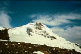
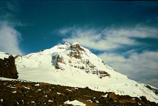
Tronador is an extinct stratovolcano
in the southern Andes
, located along the border between Argentina
and Chile
near the city of Bariloche
. The mountain was named Tronador (Spanish
for Thunderer) by locals in reference to the sound of falling serac
s. With an altitude of 3,491 m, Tronador stands more than 1000 m above nearby mountains in the Andean massif, making it a popular mountaineering destination. Located inside two National Parks, Nahuel Huapi
in Argentina and Vicente Pérez Rosales
in Chile, Tronador hosts a total of eight glacier
s, which are currently retreating due to warming of the upper troposphere
.
, a zone of high precipitations in form of both snow and rain. The humid temperate climate of the southern Andes allows several glaciers to develop due to high accumulation
rates. Most of the precipitation is produced by western frontal systems from the Pacific
. Located in the middle of the Andean massif at a latitude of 41° S Tronador is part of an alpine landscape of fjord
s, glacial lake
s and u-shaped valley
s. The forming of the landscape took place during the Quaternary glaciation
s, periods during which the whole area was covered by the Patagonian Ice Sheet
. The volcano grew during the glacials and interglacial
s of the Pleistocene
but became practically extinct in late Middle Pleistocene 300 ka ago, due to a shift in the active front of the Southern Volcanic Zone to which it belongs. Since then, glaciations and other erosive processes shaped the mountain freely without new output of lava
or tephra
. As in the case of nearby Lanín volcano
Tronador is built up mostly of basalt
s, and has seen a decline in activity as the Osorno and Calbuco volcanoes grow further west.

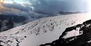
 Tronador is notable for the many glaciers covering parts of its flanks. Up to eight glaciers have been inventoried: Alerce, Ventisquero Negro, Casa Pangue, Castaño Overa , Río Blanco, Frías, Peulla and Manso. Over the last decades the glaciers on Tronador, like the majority of southern Andean glaciers, have been retreating. The Casa Pangue glacier on the northwestern side of Tronador experienced a thinning between 1961 and 1998, with an increased rate of retreat between 1981-1998 at 52 m a−1. The retreat and thinning is attributed to a decrease in precipitations and a warming of the upper troposphere
over the last decades.
Alerce Glacier, on the Argentinian side, can be visited from Refugio Otto Meiling
, a mountain hut that is sandwiched between it and Castaño Overo Glacier. Castaño Overa, also on the Argentinian side, is smaller and relatively accessible by hike from Pampa Linda. Guided trekking tours allow visitors to cross Castaño Overa or walk to Tronador's peak.
Ventisquero Negro ("black snowdrift" in Spanish) is a rather unique glacier at the base of Tronador in Nahuel Huapi National Park
. This glacier's unusual dark brown colour comes from dirt and sediment picked up in the glacier's accumulation zone, which is fed by the Río Manso Glacier several hundred metres higher up the mountain. Brown icebergs calve from the glacier and then float in a small lake until eventually melting.
, is the destination of popular day hikes, named after a mountaineer who made dozens of ascents and spent years guiding people around it. The hut is located about 1200m vertically above Pampa Linda, at the mountain's base.
Most summers the International or Anon peak (the highest of its three peaks), is climbable. However, an unusually hot summer increased rockfall to dangerous levels during January and February 2008. The Argentine side risks becoming no longer accessible due to increasingly warm weather in the region destabalising the glaciers.

Stratovolcano
A stratovolcano, also known as a composite volcano, is a tall, conical volcano built up by many layers of hardened lava, tephra, pumice, and volcanic ash. Unlike shield volcanoes, stratovolcanoes are characterized by a steep profile and periodic, explosive eruptions...
in the southern Andes
Andes
The Andes is the world's longest continental mountain range. It is a continual range of highlands along the western coast of South America. This range is about long, about to wide , and of an average height of about .Along its length, the Andes is split into several ranges, which are separated...
, located along the border between Argentina
Argentina
Argentina , officially the Argentine Republic , is the second largest country in South America by land area, after Brazil. It is constituted as a federation of 23 provinces and an autonomous city, Buenos Aires...
and Chile
Chile
Chile ,officially the Republic of Chile , is a country in South America occupying a long, narrow coastal strip between the Andes mountains to the east and the Pacific Ocean to the west. It borders Peru to the north, Bolivia to the northeast, Argentina to the east, and the Drake Passage in the far...
near the city of Bariloche
San Carlos de Bariloche
San Carlos de Bariloche, usually known as Bariloche, is a city in the , situated in the foothills of the Andes on the southern shores of Nahuel Huapi Lake and is located inside Nahuel Huapi National Park...
. The mountain was named Tronador (Spanish
Spanish language
Spanish , also known as Castilian , is a Romance language in the Ibero-Romance group that evolved from several languages and dialects in central-northern Iberia around the 9th century and gradually spread with the expansion of the Kingdom of Castile into central and southern Iberia during the...
for Thunderer) by locals in reference to the sound of falling serac
Serac
A serac is a block or column of ice formed by intersecting crevasses on a glacier. Often house-sized or larger, they are dangerous to mountaineers since they may topple with little warning...
s. With an altitude of 3,491 m, Tronador stands more than 1000 m above nearby mountains in the Andean massif, making it a popular mountaineering destination. Located inside two National Parks, Nahuel Huapi
Nahuel Huapi National Park
Established in 1934, the Nahuel Huapi National Park is the oldest national park in Argentina. It surrounds Nahuel Huapi Lake in the foothills of the Patagonian Andes. The largest of the national parks in the region, it has an area of , or nearly 2 million acres...
in Argentina and Vicente Pérez Rosales
Vicente Pérez Rosales National Park
Vicente Pérez Rosales National Park is located in Los Lagos Region, Llanquihue Province, of Chile. Its western entrance is close to the Ensenada locality, northeast of the provincial capital of Puerto Montt, and from Puerto Varas along Ruta CH-225. This national park covers about and is almost...
in Chile, Tronador hosts a total of eight glacier
Glacier
A glacier is a large persistent body of ice that forms where the accumulation of snow exceeds its ablation over many years, often centuries. At least 0.1 km² in area and 50 m thick, but often much larger, a glacier slowly deforms and flows due to stresses induced by its weight...
s, which are currently retreating due to warming of the upper troposphere
Troposphere
The troposphere is the lowest portion of Earth's atmosphere. It contains approximately 80% of the atmosphere's mass and 99% of its water vapor and aerosols....
.
Geography and geology
Tronador is located in the Wet AndesWet Andes
The Wet Andes is a climatic and glaciological subregion of the Andes. Together with the Dry Andes it is one of the two subregions of the Argentine and Chilean Andes. The Wet Andes runs from a latitude of 35°S to Cape Horn at 56°S. According to Luis Lliboutry the Wet Andes can be classified after...
, a zone of high precipitations in form of both snow and rain. The humid temperate climate of the southern Andes allows several glaciers to develop due to high accumulation
Glacier ice accumulation
Glacier ice accumulation occurs through accumulation of snow and other frozen precipitation, as well as through other means including rime ice , avalanching from hanging glaciers on cliffs and mountainsides above, and re-freezing of glacier meltwater as superimposed ice...
rates. Most of the precipitation is produced by western frontal systems from the Pacific
Pacific Ocean
The Pacific Ocean is the largest of the Earth's oceanic divisions. It extends from the Arctic in the north to the Southern Ocean in the south, bounded by Asia and Australia in the west, and the Americas in the east.At 165.2 million square kilometres in area, this largest division of the World...
. Located in the middle of the Andean massif at a latitude of 41° S Tronador is part of an alpine landscape of fjord
Fjord
Geologically, a fjord is a long, narrow inlet with steep sides or cliffs, created in a valley carved by glacial activity.-Formation:A fjord is formed when a glacier cuts a U-shaped valley by abrasion of the surrounding bedrock. Glacial melting is accompanied by rebound of Earth's crust as the ice...
s, glacial lake
Glacial lake
A glacial lake is a lake with origins in a melted glacier. Near the end of the last glacial period, roughly 10,000 years ago, glaciers began to retreat. A retreating glacier often left behind large deposits of ice in hollows between drumlins or hills. As the ice age ended, these melted to create...
s and u-shaped valley
U-shaped valley
A U-shaped valley also known as a glacial trough is one formed by the process of glaciation. It has a characteristic U-shape, with steep, straight sides, and a flat bottom. Glaciated valleys are formed when a glacier travels across and down a slope, carving the valley by the action of scouring...
s. The forming of the landscape took place during the Quaternary glaciation
Quaternary glaciation
Quaternary glaciation, also known as the Pleistocene glaciation, the current ice age or simply the ice age, refers to the period of the last few million years in which permanent ice sheets were established in Antarctica and perhaps Greenland, and fluctuating ice sheets have occurred elsewhere...
s, periods during which the whole area was covered by the Patagonian Ice Sheet
Patagonian Ice Sheet
350px|thumb|right|Map showing the extent of the Patagonian Ice Sheet in the [[Strait of Magellan]] area during the [[last glacial period]]. Selected modern settlements are shown with yellow dots...
. The volcano grew during the glacials and interglacial
Interglacial
An Interglacial period is a geological interval of warmer global average temperature lasting thousands of years that separates consecutive glacial periods within an ice age...
s of the Pleistocene
Pleistocene
The Pleistocene is the epoch from 2,588,000 to 11,700 years BP that spans the world's recent period of repeated glaciations. The name pleistocene is derived from the Greek and ....
but became practically extinct in late Middle Pleistocene 300 ka ago, due to a shift in the active front of the Southern Volcanic Zone to which it belongs. Since then, glaciations and other erosive processes shaped the mountain freely without new output of lava
Lava
Lava refers both to molten rock expelled by a volcano during an eruption and the resulting rock after solidification and cooling. This molten rock is formed in the interior of some planets, including Earth, and some of their satellites. When first erupted from a volcanic vent, lava is a liquid at...
or tephra
Tephra
200px|thumb|right|Tephra horizons in south-central [[Iceland]]. The thick and light coloured layer at center of the photo is [[rhyolitic]] tephra from [[Hekla]]....
. As in the case of nearby Lanín volcano
Lanín
Lanín is an ice-clad, cone-shaped stratovolcano on the border of Argentina and Chile. It forms part of two national parks: Lanín in Argentina and Villarrica in Chile. It is a symbol of the Argentine province of Neuquén, being part of its flag and its anthem. Although the date of its last eruption...
Tronador is built up mostly of basalt
Basalt
Basalt is a common extrusive volcanic rock. It is usually grey to black and fine-grained due to rapid cooling of lava at the surface of a planet. It may be porphyritic containing larger crystals in a fine matrix, or vesicular, or frothy scoria. Unweathered basalt is black or grey...
s, and has seen a decline in activity as the Osorno and Calbuco volcanoes grow further west.
Glaciers


Troposphere
The troposphere is the lowest portion of Earth's atmosphere. It contains approximately 80% of the atmosphere's mass and 99% of its water vapor and aerosols....
over the last decades.
Alerce Glacier, on the Argentinian side, can be visited from Refugio Otto Meiling
Otto Meiling
Otto Meiling was a German-born mountaineer who achieved many first ascents in Nahuel Huapi National Park and the surrounding area....
, a mountain hut that is sandwiched between it and Castaño Overo Glacier. Castaño Overa, also on the Argentinian side, is smaller and relatively accessible by hike from Pampa Linda. Guided trekking tours allow visitors to cross Castaño Overa or walk to Tronador's peak.
Ventisquero Negro ("black snowdrift" in Spanish) is a rather unique glacier at the base of Tronador in Nahuel Huapi National Park
Nahuel Huapi National Park
Established in 1934, the Nahuel Huapi National Park is the oldest national park in Argentina. It surrounds Nahuel Huapi Lake in the foothills of the Patagonian Andes. The largest of the national parks in the region, it has an area of , or nearly 2 million acres...
. This glacier's unusual dark brown colour comes from dirt and sediment picked up in the glacier's accumulation zone, which is fed by the Río Manso Glacier several hundred metres higher up the mountain. Brown icebergs calve from the glacier and then float in a small lake until eventually melting.
Peaks
According to the Aoneker map, these are the named peaks on Tronador: Anon or Interacional (3484m), Argentino (3187), Chileno (3262), Torre Ilse (2585). Ridges: Filo Sur (3054), Filo Blanco (3146), Filo La Vieja (2715), Filo Lamotte (2340).Mountaineering and tourism
Tronador was first climbed by Hermann Claussen solo on 29 January 1934, after several attempts. A mountain hut, Refugio Otto MeilingOtto Meiling
Otto Meiling was a German-born mountaineer who achieved many first ascents in Nahuel Huapi National Park and the surrounding area....
, is the destination of popular day hikes, named after a mountaineer who made dozens of ascents and spent years guiding people around it. The hut is located about 1200m vertically above Pampa Linda, at the mountain's base.
Most summers the International or Anon peak (the highest of its three peaks), is climbable. However, an unusually hot summer increased rockfall to dangerous levels during January and February 2008. The Argentine side risks becoming no longer accessible due to increasingly warm weather in the region destabalising the glaciers.


