
.gif)
Centennial Parkway (Hamilton, Ontario)
Encyclopedia
Hamilton, Ontario
Hamilton is a port city in the Canadian province of Ontario. Conceived by George Hamilton when he purchased the Durand farm shortly after the War of 1812, Hamilton has become the centre of a densely populated and industrialized region at the west end of Lake Ontario known as the Golden Horseshoe...
, Canada
Canada
Canada is a North American country consisting of ten provinces and three territories. Located in the northern part of the continent, it extends from the Atlantic Ocean in the east to the Pacific Ocean in the west, and northward into the Arctic Ocean...
. It is best known as the western terminus of former King's Highway 20, now maintained by the City of Hamilton. It starts off as Upper Centennial Parkway, a mountain-access road in the City right before the Canadian Pacific Railway
Canadian Pacific Railway
The Canadian Pacific Railway , formerly also known as CP Rail between 1968 and 1996, is a historic Canadian Class I railway founded in 1881 and now operated by Canadian Pacific Railway Limited, which began operations as legal owner in a corporate restructuring in 2001...
line at the backend of Battlefield Park and is a two-way street
Two-way street
A two-way street is a street that allows vehicles to travel in both directions. On most two-way streets, especially main streets, a line is painted down the middle of the road to remind drivers to stay on their side of the road. Sometimes one portion of a street is two-way, the other portion one-way...
throughout that extends north over the Queen Elizabeth Way and ends at Beach Boulevard
Beach Boulevard (Hamilton, Ontario)
Beach Boulevard is a Lower city street in Hamilton, Ontario, Canada, north of the Hamilton Harbour on a thin piece of land that crosses over Lake Ontario and stretches from where Woodward Avenue becomes Eastport Drive in the east to near the Lift Bridge in the west at Eastport Drive . It runs...
/ Van Wagners Beach Road in front of Confederation Park.
History
In the late 1920s, the Department of Highways assumed the route north of the Hamilton & Queenston Provincial Highway (Highway 8Highway 8 (Ontario)
Provincial Highway 8 is a provincially maintained highway in the Canadian province of Ontario. Its total length is 138.5 km, though it was once much longer, running farther east from Hamilton to Niagara Falls, before the Queen Elizabeth Way replaced its role.- History :Highway 8 is one of the...
) as Provincial Highway 8A, a quick connector to Highway 2 via Hamilton Beach (the site of the current Burlington Bay James N. Allan Skyway bridge
Burlington Bay James N. Allan Skyway
The Burlington Bay James N. Allan Skyway, originally called the Burlington Bay Skyway, is a pair of high-level freeway bridges located in Hamilton and Burlington, Ontario, Canada...
). It was renamed Highway 20 when the route connecting it to Niagara Falls
Niagara Falls, Ontario
Niagara Falls is a Canadian city on the Niagara River in the Golden Horseshoe region of Southern Ontario. The municipality was incorporated on June 12, 1903...
was completed, and a traffic circle (bisected by a railway) was created for the intersection with the Queen Elizabeth Way, completed in 1939. A series of provincial downloads in the late 1990s saw the majority of Highway 20
Highway 20 (Ontario)
King's Highway 20, also known as Highway 20, is a provincially maintained highway in the Canadian province of Ontario. Presently, it is a short stub between Highway 58 and Niagara Regional Road 70 in the town of Thorold.- History :...
downloaded to municipal and regional authorities; the City of Hamilton now maintains the entire route within its borders as (Upper) Centennial Parkway, or "Hamilton Highway 20".
The Battle of Stoney Creek
Battle of Stoney Creek
The Battle of Stoney Creek was fought on 6 June 1813 during the War of 1812 near present day Stoney Creek, Ontario. British units made a night attack on an American encampment...
was fought on June 6, 1813, during the War of 1812
War of 1812
The War of 1812 was a military conflict fought between the forces of the United States of America and those of the British Empire. The Americans declared war in 1812 for several reasons, including trade restrictions because of Britain's ongoing war with France, impressment of American merchant...
near present day Stoney Creek, Ontario. British
United Kingdom of Great Britain and Ireland
The United Kingdom of Great Britain and Ireland was the formal name of the United Kingdom during the period when what is now the Republic of Ireland formed a part of it....
units made a night attack on an American
United States
The United States of America is a federal constitutional republic comprising fifty states and a federal district...
encampment. Due in large part to the capture of both American brigadier generals, and an overestimation of British strength by the Americans, the battle was a victory for the British, and a turning point in the defence of Upper Canada
Upper Canada
The Province of Upper Canada was a political division in British Canada established in 1791 by the British Empire to govern the central third of the lands in British North America and to accommodate Loyalist refugees from the United States of America after the American Revolution...
.
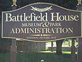
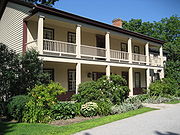
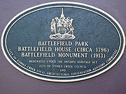
Battlefield House
Battlefield House (Stoney Creek)
Battlefield House near King Street East and Centennial Parkway in Stoney Creek, Hamilton, Ontario, Canada is a living history museum and site of the historic Battle of Stoney Creek on June 6, 1813, which was fought during the War of 1812. It was built in 1796...
, built in 1796, and fifteen and one-half acres of parkland, (Battlefield Park), was property of the Women's Wentworth Historical Society, (1899-1962), and given by this society to the Niagara Parks Commission
Niagara Parks Commission
The Niagara Parks Commission, or Niagara Parks for short, is an agency of government of Ontario which maintains the Ontario shoreline of the Niagara River.- History :...
as a National historical site on January 19, 1962.
One can reach the Bruce Trail
Bruce Trail
The Bruce Trail is a hiking trail in southern and central Ontario, Canada.-General:The trail follows the edge of the Niagara Escarpment, one of the thirteen UNESCO World Biosphere Reserves in Canada, for almost...
via Centennial Parkway South. From this point southwards the road is then known as Upper Centennial Parkway and is one of many mountain-access roads in the city. The Bruce trail cuts through Hamilton along the Niagara Escarpment
Niagara Escarpment
The Niagara Escarpment is a long escarpment, or cuesta, in the United States and Canada that runs westward from New York State, through Ontario, Michigan, Wisconsin and Illinois...
(mountain) and used by many locals for a full days hike. The Trail is over 690 kilometres long and starts at Niagara Falls
Niagara Falls, Ontario
Niagara Falls is a Canadian city on the Niagara River in the Golden Horseshoe region of Southern Ontario. The municipality was incorporated on June 12, 1903...
, passes through Hamilton and ends at the Bruce Peninsula
Bruce Peninsula
The Bruce Peninsula is a peninsula in Ontario, Canada that lies between Georgian Bay and the main basin of Lake Huron. The peninsula extends roughly northwestwards from the rest of Southern Ontario, pointing towards Manitoulin Island, with which it forms the widest strait joining Georgian Bay to...
. Hikers are lead to scenic gorges, hidden waterfalls and places of quiet charm.
Picnickers have an excellent choice of numerous parks in Hamilton. Confederation Park is a popular lakeside retreat for those who wish to pack a lunch and go. Camping facilities are also available for extended visits. The park also has playgrounds, beaches and Wild Waterworks, which features the largest outdoor wave pool in the world, waterslides, lazy river, batting cages, mini put and a picnic area.
Landmarks
Note: Listing of Landmarks from North to South.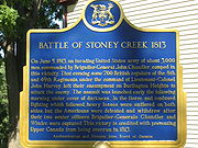
- Van Wagner's Beach (off Van Wagner's Beach Road)
- Confederation Park
- Wild Waterworks, (at Confederation Park)
- Holiday InnHoliday InnHoliday Inn is a brand of hotels, formally a economy motel chain, forming part of the British InterContinental Hotels Group . It is one of the world's largest hotel chains with 238,440 bedrooms and 1,301 hotels globally. There are currently 5 hotels in the pipeline...
Express Hotel (off Goderich Road) - Pines Motel/ Pine Tree Restaurant
- Comfort Inn (motel)
- Parkway Plaza (shopping)
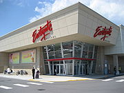
- Eastgate Square (Mall)
- Gulliver Square (shopping)
- Battlefield Square Plaza (shopping)
- Cardinal Newman Secondary SchoolCardinal Newman Secondary SchoolCardinal Newman Secondary School is a Separate high school in the community of Stoney Creek in Hamilton, Ontario, Canada. It is part of the Hamilton-Wentworth Catholic District School Board...
- Stoney Creek Cemetery
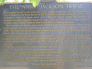
- The Nash-Jackson House
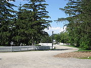
- Stoney Creek Battlefield ParkBattlefield ParkBattlefield Park is a park in the center of Belize City, Belize. The park has served as the preferred meeting place of Belize's inhabitants since 1638. Labour activist Antonio Soberanis Gómez' Labourers and Unemployed Association got its start there, as did the People's United Party and other...
, where the Battle of Stoney CreekBattle of Stoney CreekThe Battle of Stoney Creek was fought on 6 June 1813 during the War of 1812 near present day Stoney Creek, Ontario. British units made a night attack on an American encampment...
took place during the War of 1812War of 1812The War of 1812 was a military conflict fought between the forces of the United States of America and those of the British Empire. The Americans declared war in 1812 for several reasons, including trade restrictions because of Britain's ongoing war with France, impressment of American merchant...
.- Battlefield HouseBattlefield House (Stoney Creek)Battlefield House near King Street East and Centennial Parkway in Stoney Creek, Hamilton, Ontario, Canada is a living history museum and site of the historic Battle of Stoney Creek on June 6, 1813, which was fought during the War of 1812. It was built in 1796...
- Soney Creek Battlefield Monument
- Battlefield House
- Upper Centennial Parkway, a Mountain-access road
- Bruce TrailBruce TrailThe Bruce Trail is a hiking trail in southern and central Ontario, Canada.-General:The trail follows the edge of the Niagara Escarpment, one of the thirteen UNESCO World Biosphere Reserves in Canada, for almost...
, many waterfalls found along this trail.- Felker's FallsFelker's Falls (Hamilton, Ontario)Felker's Falls is a 22 metre high ribbon style waterfall found at the Felker's Falls Conservation Area, a small park within a subdivision in near Stoney Creek in East Hamilton, Ontario, Canada...
- Little Davis FallsLittle Davis Falls (Hamilton, Ontario)Little Davis Falls is a 3 metre high twin curtain waterfall found in Hamilton, Ontario, Canada.Nearby attractions include Bruce Trail, Mount Albion Conservation Area, Felker's Falls, Felker's Falls Conservation Area, King's Forest Golf Course, Mohawk Sports Park, Glendale Golf Course, Escarpment...
- Glover's FallsGlover’s Falls (Hamilton, Ontario)Glover's Falls is an 8 metre high complex ribbon cascade waterfall found in Hamilton, Ontario, Canada.Nearby attractions include Bruce Trail, East Glover's Falls, Mount Albion Conservation Area, Felker's Falls, Felker's Falls Conservation Area, King's Forest Golf Course, Mohawk Sports Park,...
- Billy Green FallsBilly Green Falls (Hamilton, Ontario)Billy Green Falls is a 17 metre high complex ribbon waterfall found in Battlefield Creek, Stoney Creek, Hamilton, Ontario, Canada.Billy Green Falls is named after Billy Green, the scout in the Battle of Stoney Creek , an epic conflict during the famous war of 1812-14.Nearby attractions include...
- Devil's Punch BowlDevil's Punch Bowl (Hamilton, Ontario)Devil's Punch Bowl is a 37 metre ribbon waterfall on the Niagara Escarpment, in the Stoney Creek community of Hamilton, Ontario, Canada. It is found in the Devil's Punchbowl Conservation Area, maintained by the Hamilton Conservation Authority, and features an escarpment access trail with...
- Felker's Falls
- Mountain Face Park
- Niagara EscarpmentNiagara EscarpmentThe Niagara Escarpment is a long escarpment, or cuesta, in the United States and Canada that runs westward from New York State, through Ontario, Michigan, Wisconsin and Illinois...
(mountain)
Communities
Note: Listing of neighbourhoods from North to South- Nashdale/ Lakely, Centennial Parkway is the division between these two neighbourhoods.
- Kentley/ Riverdale West, Centennial Parkway is the division line between these two neighbourhoods.
- Greenford
Major intersecting roads
Note: Listing of streets from North to South.- Beach BoulevardBeach Boulevard (Hamilton, Ontario)Beach Boulevard is a Lower city street in Hamilton, Ontario, Canada, north of the Hamilton Harbour on a thin piece of land that crosses over Lake Ontario and stretches from where Woodward Avenue becomes Eastport Drive in the east to near the Lift Bridge in the west at Eastport Drive . It runs...
/ Van Wagners Beach Road - Queen Elizabeth Expressway (travels underneath the Centennial Parkway bridge)
- Barton StreetBarton Street (Hamilton, Ontario)Barton Street is an arterial road in the Lower City of Hamilton, Ontario, Canada. It's also the longest street in the city. It starts off at the Western end of town at Locke Street North and is a two-way street that stretches eastward through a number of different and varied communities in the...
East - Queenston RoadQueenston Road (Hamilton, Ontario)Queenston Road is a two-way Lower City arterial road in Hamilton, Ontario, Canada. Also known as Highway 8. It starts off at the Queenston Traffic Circle and travels eastward over the Red Hill Valley Parkway and into Stoney Creek past the Fruitland and Winona communities and into Niagara Region as...
- King Street East
Parallel roads
Note: Listing of streets from West to East.- Kenilworth AvenueKenilworth Avenue (Hamilton, Ontario)Kenilworth Avenue, is a Lower City arterial road in Hamilton, Ontario, Canada. It starts off at the Kenilworth Traffic Circle and Kenilworth Access, a mountain-access road at the base of the Niagara Escarpment and is a two-way street throughout stretching northward through the city's North End...
, North, South - Cochrane RoadCochrane Road (Hamilton, Ontario)Cochrane Road is a two-way Lower City collector road in Hamilton, Ontario, Canada. It starts off at the Queenston Traffic Circle and travels South between the Bartonville and Glenview neighbourhoods right through to the Rosedale neighbourhood where it ends at Greenhill Avenue in front of Rosedale...
- Parkdale AvenueParkdale Avenue (Hamilton, Ontario)Parkdale Avenue, is a Lower City arterial road in Hamilton, Ontario, Canada. It starts off just South of Lawrence Road at Hixon Road and is a two-way street throughout, stretching northward through the city's North End industrial neighbourhood and ends just north of the Burlington Street East...
, North, South - Red Hill Valley ParkwayRed Hill Valley ParkwayThe Red Hill Valley Parkway , referred to as the Red Hill Creek Expressway during planning is a municipal expressway in the Canadian city of Hamilton, Ontario. The route connects the Lincoln M. Alexander Parkway, Hamilton's second municipal expressway, to the Queen Elizabeth Way near Hamilton...
- Nash RoadNash Road (Hamilton, Ontario)Nash Road is a Lower City street in Hamilton, Ontario, Canada. It starts off at King Street East in front of the Father Sean O'Sullivan Memorial Park and is a two-way collector road throughout that extends north to the Nashdale neighbourhood past Bancroft Street where it then hangs a right and...
, North, South - Woodward AvenueWoodward Avenue (Hamilton, Ontario)Woodward Avenue is an arterial road in Hamilton, Ontario, Canada. It starts in the north-end as Eastport Drive and the road changes its name south of Burlington Street beside the Museum of Steam & Technology to Woodward Avenue and extends southward and ends at Melvin Avenue...
- Centennial Parkway, North, South
- Lake Avenue, North, Drive
- Gray Road
- Green Road
- Dewitt Road
- Fruitland Road
- 50 Road