

Cochrane Road (Hamilton, Ontario)
Encyclopedia
Cochrane Road is a two-way Lower City collector road in Hamilton, Ontario
Hamilton, Ontario
Hamilton is a port city in the Canadian province of Ontario. Conceived by George Hamilton when he purchased the Durand farm shortly after the War of 1812, Hamilton has become the centre of a densely populated and industrialized region at the west end of Lake Ontario known as the Golden Horseshoe...
, Canada
Canada
Canada is a North American country consisting of ten provinces and three territories. Located in the northern part of the continent, it extends from the Atlantic Ocean in the east to the Pacific Ocean in the west, and northward into the Arctic Ocean...
. It starts off at the Queenston Traffic Circle and travels South between the Bartonville and Glenview neighbourhoods right through to the Rosedale neighbourhood where it ends at Greenhill Avenue in front of Rosedale Park. From this point onwards the road is now known as Whitehouse Road and weaves its way through King's Forest Golf Course and King's Forest Park.
History
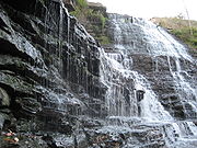
Albion FallsAlbion Falls
Albion Falls is a classical/cascade waterfall flowing down the Niagara Escarpment in Red Hill Valley, in Hamilton, Ontario, Canada. With cascade falls the downpour is staggered into a series of steps causing water to "cascade". The top of the falls are located on Mud Street...
, a classical/cascade waterfall, and one of Hamilton's 100+ waterfalls, can be found here at the back-end of King's Forest Park. A nearby parking lot was removed when the construction of the nearby Red Hill Valley Parkway
Red Hill Valley Parkway
The Red Hill Valley Parkway , referred to as the Red Hill Creek Expressway during planning is a municipal expressway in the Canadian city of Hamilton, Ontario. The route connects the Lincoln M. Alexander Parkway, Hamilton's second municipal expressway, to the Queen Elizabeth Way near Hamilton...
started. A parking lot at Mountain Brow Road above the falls for 50+ cars is still available for visitors. Up to the early 1900s a small vibrant village called Albion Mills was found here. The rocks from Albion Falls area were used to construct the Rock Garden at the Royal Botanical Gardens. Another waterfall can be found nearby, northwest of Albion Falls called, Buttermilk Falls
Buttermilk Falls
Buttermilk Falls is a 23 metre high plunge waterfall found below Oak Knoll Park Buttermilk Falls is a 23 metre high plunge waterfall found below Oak Knoll Park Buttermilk Falls is a 23 metre high plunge waterfall found below Oak Knoll Park (adjacent to King's Forest Park, Mountain Brow Boulevard...
. Not too far off and just East of the newly built Red Hill Valley Parkway at the Glendale Golf & Country Club is another waterfall
Waterfall
A waterfall is a place where flowing water rapidly drops in elevation as it flows over a steep region or a cliff.-Formation:Waterfalls are commonly formed when a river is young. At these times the channel is often narrow and deep. When the river courses over resistant bedrock, erosion happens...
called, Glendale Falls
Glendale Falls (Hamilton, Ontario)
Glendale Falls is a 3 metre high terraced classic waterfall found in Hamilton, Ontario, Canada.Nearby attractions include the Bruce Trail, Mount Albion Conservation Area, Albion Falls, King's Forest Golf Course, Buttermilk Falls, Mohawk Sports Park, Glendale Golf Course, Escarpment Rail Trail,...
on Mount Albion Road.
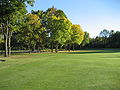
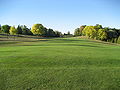
King's Forest Golf Club was established in 1974 and is run by the city of Hamilton. The Red Hill Creek and many fair-sized ponds come into play. Credited as being one of the very best municipally owned courses in Canada.
Landmarks
- Queenston Traffic Circle
- Bartonville Cemetery
- Canadian Pacific RailwayCanadian Pacific RailwayThe Canadian Pacific Railway , formerly also known as CP Rail between 1968 and 1996, is a historic Canadian Class I railway founded in 1881 and now operated by Canadian Pacific Railway Limited, which began operations as legal owner in a corporate restructuring in 2001...
line - Rosedale Park
- Rosedale Arena
- Red Hill Valley Trail (East of Arena)
- Red Hill Valley ParkwayRed Hill Valley ParkwayThe Red Hill Valley Parkway , referred to as the Red Hill Creek Expressway during planning is a municipal expressway in the Canadian city of Hamilton, Ontario. The route connects the Lincoln M. Alexander Parkway, Hamilton's second municipal expressway, to the Queen Elizabeth Way near Hamilton...
(East of Arena/Park) - Escarpment Rail Trail (abandoned railway path)
- Chippawa Rail Trail (abandoned railway path)
- King's Forest Park
- King's Forest Golf Course
- Bruce TrailBruce TrailThe Bruce Trail is a hiking trail in southern and central Ontario, Canada.-General:The trail follows the edge of the Niagara Escarpment, one of the thirteen UNESCO World Biosphere Reserves in Canada, for almost...
(West of golf course) - Red Hill Creek (East of golf course)
- Bruce Trail
- Oak Knoll Park
- Buttermilk FallsButtermilk FallsButtermilk Falls is a 23 metre high plunge waterfall found below Oak Knoll Park Buttermilk Falls is a 23 metre high plunge waterfall found below Oak Knoll Park Buttermilk Falls is a 23 metre high plunge waterfall found below Oak Knoll Park (adjacent to King's Forest Park, Mountain Brow Boulevard...
(backend of King's Forest Park) - Albion FallsAlbion FallsAlbion Falls is a classical/cascade waterfall flowing down the Niagara Escarpment in Red Hill Valley, in Hamilton, Ontario, Canada. With cascade falls the downpour is staggered into a series of steps causing water to "cascade". The top of the falls are located on Mud Street...
(backend of King's Forest Park) - Glendale FallsGlendale FallsGlendale Falls may refer to:*Glendale Falls *Glendale Falls...
(backend of King's Forest Park)
Communities
Note: Listing of neighbourhoods from North to South- Bartonville/Glenview, Cochrane Road is the division between these two neighbourhoods.
- Rosedale
Intersecting streets
Note: Listing of streets from North to South.- Main StreetMain Street (Hamilton, Ontario)Main Street, is a Lower City arterial road in Hamilton, Ontario, Canada. It starts east of Wilson Street in Ancaster at White Chapel Cemetery as a two-way street and switches over to a one-way street at Paradise Road South, in Westdale, where it continues up to the Delta where it once again...
East - Queenston RoadQueenston Road (Hamilton, Ontario)Queenston Road is a two-way Lower City arterial road in Hamilton, Ontario, Canada. Also known as Highway 8. It starts off at the Queenston Traffic Circle and travels eastward over the Red Hill Valley Parkway and into Stoney Creek past the Fruitland and Winona communities and into Niagara Region as...
- King Street East
- Lawrence Road
Parallel streets
Note: Listing of streets from West to East.- Victoria AvenueVictoria Avenue (Hamilton, Ontario)Victoria Avenue, is a Lower City arterial road in Hamilton, Ontario, Canada. It starts off as a ramp and part of a Mountain-access road, the Claremont Access, on Hunter Street East in the Stinson neighbourhood...
, North, South - Wentworth StreetWentworth Street (Hamilton, Ontario)Wentworth Street, is a Lower City arterial road in Hamilton, Ontario, Canada. It starts off at the base of the Niagara Escarpment on Charlton Avenue East just before the CP lines as a two-way street for 2-blocks up past Cumberland Avenue up to Rutherford Avenue where it then switches over to a...
, North, South - Sherman AvenueSherman Avenue (Hamilton, Ontario)Sherman Avenue, is a Lower City collector road in Hamilton, Ontario, Canada. It starts off at the base of the Niagara Escarpment just south of Cumberland Avenue and is a one-way street northbound that cuts through the city's North End industrial neighbourhood and ends at Ship Street, the site of...
, North, South - Gage AvenueGage Avenue (Hamilton, Ontario)thumb|right|350px|Gage Park WaterfountainGage Avenue, is a Lower City arterial road in Hamilton, Ontario, Canada. It starts off at Lawrence Road at the base of the Niagara Escarpment at the south end of Gage Park...
, North, South - Ottawa StreetOttawa Street (Hamilton, Ontario)Ottawa street, is a Lower City arterial road in Hamilton, Ontario, Canada. It starts off at Lawrence Road at the base of the Niagara Escarpment and is a two-way street throughout cutting through the Delta and Crown Point neighbourhoods and the City's North End industrial neighbourhood...
, North, South - Kenilworth AvenueKenilworth Avenue (Hamilton, Ontario)Kenilworth Avenue, is a Lower City arterial road in Hamilton, Ontario, Canada. It starts off at the Kenilworth Traffic Circle and Kenilworth Access, a mountain-access road at the base of the Niagara Escarpment and is a two-way street throughout stretching northward through the city's North End...
, North, South - Cochrane Road
- Parkdale AvenueParkdale Avenue (Hamilton, Ontario)Parkdale Avenue, is a Lower City arterial road in Hamilton, Ontario, Canada. It starts off just South of Lawrence Road at Hixon Road and is a two-way street throughout, stretching northward through the city's North End industrial neighbourhood and ends just north of the Burlington Street East...
, North, South - Red Hill Valley ParkwayRed Hill Valley ParkwayThe Red Hill Valley Parkway , referred to as the Red Hill Creek Expressway during planning is a municipal expressway in the Canadian city of Hamilton, Ontario. The route connects the Lincoln M. Alexander Parkway, Hamilton's second municipal expressway, to the Queen Elizabeth Way near Hamilton...
- Nash RoadNash Road (Hamilton, Ontario)Nash Road is a Lower City street in Hamilton, Ontario, Canada. It starts off at King Street East in front of the Father Sean O'Sullivan Memorial Park and is a two-way collector road throughout that extends north to the Nashdale neighbourhood past Bancroft Street where it then hangs a right and...
, North, South - Woodward AvenueWoodward Avenue (Hamilton, Ontario)Woodward Avenue is an arterial road in Hamilton, Ontario, Canada. It starts in the north-end as Eastport Drive and the road changes its name south of Burlington Street beside the Museum of Steam & Technology to Woodward Avenue and extends southward and ends at Melvin Avenue...
- Centennial ParkwayCentennial Parkway (Hamilton, Ontario)Centennial Parkway, is a Lower City arterial road in Hamilton, Ontario, Canada. It is best known as the western terminus of former King's Highway 20, now maintained by the City of Hamilton...
, North, South - Lake Avenue, North, Drive