

Highways passing from Delhi
Encyclopedia
Delhi
, a major metropolitan region of India
, is connected to various parts of country through several national highways. Most of the highways from Delhi
lead to Haryana
or Uttar Pradesh
and continue from there. Delhi
is directly connected to the state of Haryana
by The Delhi-Gurgaon Expressway and National Highway 8 to city of Gurgaon
, National Highway 2
to the city of Faridabad
, National Highway 1
to the city of Panipat
, and National Highway 10
to the city of Rohtak
. Delhi
is directly connected to the state of Uttar Pradesh
by the DND Flyway
to the city of Noida
and National Highway 24
to Ghaziabad.
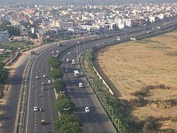 Delhi-Gurgaon Expresswayis a 28 km long access-controlled toll expressway connecting Delhi
, the national capital of India, and Gurgaon
on National Highway 8 (India) The highway runs from Delhi
to Mumbai
, Delhi-Gurgaon Expressway
till outskirts of Gurgaon
. The expressway is a part of Golden Quadrilateral
project, which itself is a part of ambitious National Highway Development Project (NHDP) and emphasizes improving road connectivity between four metropolitan cities of India, namely Delhi, Mumbai
, Chennai
and Kolkata
by developing 4–6 lane highways between them.
The much-delayed Rs.10 billion, 27.7 km expressway was thrown open on January 23, 2008. It has helped reduce the travel time of hundreds of thousands of commuters and international air passengers. ehicle users have to pay a toll for using the expressway, which is collected at three points, near the Indira Gandhi International Airport, the Delhi-Gurgaon Border and the 42nd Milestone.
Since it began operation, it has also achieved notoriety for a large number of accidents involving pedestrians. There are only two overbridges along the entire stretch to cater to the communities living on either side of heavily populated areas through which the expressway runs. The toll plaza at the Delhi-Gurgaon border has also proved inadequate to handle the increasing traffic, leading to traffic jams during peak hours. Though the plaza is tag enabled, only 40 percent of the traffic that passes through avails of this facility.
 The Delhi Noida Direct Flyway (DND) is an eight-laned access controlled tolled expressway
which connects Delhi
to Noida
, an industrial suburb area. It was built and is maintained by The Noida Toll Bridge Company Ltd. The acronym DND stands for "Delhi-Noida Direct". The project, built by the Noida Toll Bridge Company Ltd. (NTBCL) was developed under a Build-Own-Operate-Transfer (BOOT) model. The Noida Toll Bridge Company promoted by the Infrastructure Leasing and Financial Services (IL&FS). The project included the construction of a flyover at Ashram Chowk and the construction of a 552.5 meter bridge over the Yamuna
river.
.png)
National Highway 1 or (NH 1) is a National Highway in Northern India that links the National capital New Delhi
to the town of Attari
in Punjab
near the Indo-Pakistani border. The highway is maintained by National Highways Authority of India
. The highway originally started from Lahore
in Pakistan
. This is one of the longest and oldest highways of India
.
The present day NH 1 passes through Amritsar
, Jalandhar
, Ludhiana, Ambala
, Kurukshetra
, Karnal
, Panipat
, Sonipat
and Delhi
. It runs for a distance of 456 km. The Delhi–Lahore Bus travels on NH 1 in India. NH 1 presently has 4 different spur routes designated as 1A, 1B, 1C and 1D. Approximately 380 km stretch of NH 1 from Jalandhar
to Delhi
is a part of the North-South Corridor
.
.png)
National Highway 2 (NH 2), commonly referred as Delhi-Kolkata Road is a busy India
n National Highway that runs through the states of Delhi
, Haryana
, Uttar Pradesh
, Bihar
, Jharkhand
, and West Bengal
. It constitute a major portion of historical Grand Trunk Road
along with NH 91 and NH 1 in India. The road is the part of National Highway network of India, and it is officially listed as running over 1465 km from Delhi to Kolkata. The km in each of the states are Delhi (12), Haryana (74), Uttar Pradesh (752), Bihar (202), Jharkhand (190), West Bengal (235).
The highway touches the cities of Faridabad
in Haryana, Mathura, Agra
, Etawah
, Bhoganipur
, Kanpur, Allahabad
, Varanasi
in Uttar Pradesh, Mohania
in Bihar
, Barhi, Dhanbad
in Jharkhand
and Asansol
, Durgapur, Kolkata
in West Bengal
.
Almost all of the 1465 km stretch of NH 2 has been selected as a part of the Golden Quadrilateral
by the National Highways Development Project
. Approximately 253 km stretch of NH 2 between Delhi
and Agra
has been selected as a part of the North-South Corridor
by the National Highways Development Project
.Approximately 35 km stretch of NH 2 between Barah and Kanpur has been selected as a part of the East-West Corridor
by the National Highways Development Project
.
.png) National Highway 8 (NH 8), is a National Highway i4n India
National Highway 8 (NH 8), is a National Highway i4n India
that connects the Indian capital city of New Delhi
with the Indian Financial capital city of Mumbai
. The highway passes through the State capitals of Gandhinagar and Jaipur
, as well as important cities like Ahmedabad
, Surat
and Vadodara
.
This highway is part of the Golden Quadrilateral
project undertaken by National Highways Authority of India
. and was the first part to be completed. The Delhi-Gurgaon Expressway
is a part of NH 8. Before entering downtown Mumbai, NH 8 passes through nearly all suburbs on the Western line of Mumbai Suburban Railway
, where it is popularly known as Western Express Highway
.
.png)
National Highway 10 (NH 10) is a National Highway in northern India
that originates at Delhi
and ends at the town of Fazilka
in Punjab
near the Indo-Pakistani border.
.png)
National Highway 24 or NH 24 is a National Highway in India
that connects the National capital Delhi
to Uttar Pradesh
state capital Lucknow
running 438 kilometers in length.
Delhi
Delhi , officially National Capital Territory of Delhi , is the largest metropolis by area and the second-largest by population in India, next to Mumbai. It is the eighth largest metropolis in the world by population with 16,753,265 inhabitants in the Territory at the 2011 Census...
, a major metropolitan region of India
India
India , officially the Republic of India , is a country in South Asia. It is the seventh-largest country by geographical area, the second-most populous country with over 1.2 billion people, and the most populous democracy in the world...
, is connected to various parts of country through several national highways. Most of the highways from Delhi
Delhi
Delhi , officially National Capital Territory of Delhi , is the largest metropolis by area and the second-largest by population in India, next to Mumbai. It is the eighth largest metropolis in the world by population with 16,753,265 inhabitants in the Territory at the 2011 Census...
lead to Haryana
Haryana
Haryana is a state in India. Historically, it has been a part of the Kuru region in North India. The name Haryana is found mentioned in the 12th century AD by the apabhramsha writer Vibudh Shridhar . It is bordered by Punjab and Himachal Pradesh to the north, and by Rajasthan to the west and south...
or Uttar Pradesh
Uttar Pradesh
Uttar Pradesh abbreviation U.P. , is a state located in the northern part of India. With a population of over 200 million people, it is India's most populous state, as well as the world's most populous sub-national entity...
and continue from there. Delhi
Delhi
Delhi , officially National Capital Territory of Delhi , is the largest metropolis by area and the second-largest by population in India, next to Mumbai. It is the eighth largest metropolis in the world by population with 16,753,265 inhabitants in the Territory at the 2011 Census...
is directly connected to the state of Haryana
Haryana
Haryana is a state in India. Historically, it has been a part of the Kuru region in North India. The name Haryana is found mentioned in the 12th century AD by the apabhramsha writer Vibudh Shridhar . It is bordered by Punjab and Himachal Pradesh to the north, and by Rajasthan to the west and south...
by The Delhi-Gurgaon Expressway and National Highway 8 to city of Gurgaon
Gurgaon
Gurgaon is the second largest city in the Indian state of Haryana. Gurgaon is the industrial and financial center of Haryana. It is located 30 km south of national capital New Delhi, about 10 kilometers from Dwarka Sub City and 268 km south of Chandigarh, the state capital...
, National Highway 2
National Highway 2 (India)
National Highway 2 , commonly referred as Delhi-Kolkata Road is a busy Indian National Highway that runs through the states of Delhi, Haryana, Uttar Pradesh, Bihar, Jharkhand, and West Bengal. It constitute a major portion of historical Grand Trunk Road along with NH 91 and NH 1 in India...
to the city of Faridabad
Faridabad
Faridabad is a city in the south-east of Haryana state in northern India, in Faridabad district. It lies at 28º 25' 16" N Latitude and 77º 18' 28" E Longitude. The district shares its boundaries with the National Capital and Union Territory of Delhi to its north, Gurgaon district to the west and...
, National Highway 1
National Highway 1 (India)
National Highway 1 or is a National Highway in Northern India that links the National capital New Delhi to the town of Attari in Punjab near the India-Pakistan International border. This was a part of Grand Trunk Road of Sher Shah Suri, that ran from Lahore to Bengal, built on earlier roads that...
to the city of Panipat
Panipat
Panipat بَنِبَت is an ancient and historic city in Panipat district, Haryana state, India. It is 90 km north from Delhi and 169 km south of Chandigarh on NH-1. The three battles fought at the city were turning points in Indian history. The city is famous in India by the name of "City of...
, and National Highway 10
National Highway 10 (India)
National Highway 10 a National Highway, length , in northern India that originates at Delhi and ends at the town of Fazilka in Punjab near the Indo-Pak Border.-External links:* Map of NH-10...
to the city of Rohtak
Rohtak
Rohtak City is a Municipal Corporation in Rohtak district that styles itself as the "Heart of Haryana". It is located 70 km Northwest of New Delhi and 210 km South of the state capital Chandigarh at the NH 10...
. Delhi
Delhi
Delhi , officially National Capital Territory of Delhi , is the largest metropolis by area and the second-largest by population in India, next to Mumbai. It is the eighth largest metropolis in the world by population with 16,753,265 inhabitants in the Territory at the 2011 Census...
is directly connected to the state of Uttar Pradesh
Uttar Pradesh
Uttar Pradesh abbreviation U.P. , is a state located in the northern part of India. With a population of over 200 million people, it is India's most populous state, as well as the world's most populous sub-national entity...
by the DND Flyway
DND Flyway
DND Flyway is an eight-laned access controlled tolled expressway which connects Delhi to Noida, an industrial suburb area. It was built and is maintained by The Noida Toll Bridge Company Ltd. The acronym DND stands for "Delhi-Noida Direct".-Construction:The project, built by the Noida Toll Bridge...
to the city of Noida
Noida
Noida , short for the New Okhla Industrial Development Area, is an area in India under the management of the New Okhla Industrial Development Authority . Noida came into administrative existence on 17 April 1976 and celebrates 17 April as "Noida Day". It was set up as part of an urbanization...
and National Highway 24
National Highway 24 (India)
National Highway 24 or NH 24 is a National Highway in India that connects the National capital Delhi to Uttar Pradesh state capital Lucknow running in length....
to Ghaziabad.
Delhi-Gurgaon Expressway on National Highway 8
Delhi
Delhi , officially National Capital Territory of Delhi , is the largest metropolis by area and the second-largest by population in India, next to Mumbai. It is the eighth largest metropolis in the world by population with 16,753,265 inhabitants in the Territory at the 2011 Census...
, the national capital of India, and Gurgaon
Gurgaon
Gurgaon is the second largest city in the Indian state of Haryana. Gurgaon is the industrial and financial center of Haryana. It is located 30 km south of national capital New Delhi, about 10 kilometers from Dwarka Sub City and 268 km south of Chandigarh, the state capital...
on National Highway 8 (India) The highway runs from Delhi
Delhi
Delhi , officially National Capital Territory of Delhi , is the largest metropolis by area and the second-largest by population in India, next to Mumbai. It is the eighth largest metropolis in the world by population with 16,753,265 inhabitants in the Territory at the 2011 Census...
to Mumbai
Mumbai
Mumbai , formerly known as Bombay in English, is the capital of the Indian state of Maharashtra. It is the most populous city in India, and the fourth most populous city in the world, with a total metropolitan area population of approximately 20.5 million...
, Delhi-Gurgaon Expressway
Delhi-Gurgaon Expressway
Delhi-Gurgaon Expressway is a long access-controlled toll expressway connecting Delhi, the national capital of India, and Gurgaon, an important satellite city of Haryana....
till outskirts of Gurgaon
Gurgaon
Gurgaon is the second largest city in the Indian state of Haryana. Gurgaon is the industrial and financial center of Haryana. It is located 30 km south of national capital New Delhi, about 10 kilometers from Dwarka Sub City and 268 km south of Chandigarh, the state capital...
. The expressway is a part of Golden Quadrilateral
Golden Quadrilateral
The Golden Quadrilateral is a highway network connecting India's four largest metropolises: Delhi, Mumbai, Chennai and Kolkata, thus forming a quadrilateral of sorts. Four other top ten metropolises: Bangalore, Pune, Ahmedabad, and Surat, are also served by the network...
project, which itself is a part of ambitious National Highway Development Project (NHDP) and emphasizes improving road connectivity between four metropolitan cities of India, namely Delhi, Mumbai
Mumbai
Mumbai , formerly known as Bombay in English, is the capital of the Indian state of Maharashtra. It is the most populous city in India, and the fourth most populous city in the world, with a total metropolitan area population of approximately 20.5 million...
, Chennai
Chennai
Chennai , formerly known as Madras or Madarasapatinam , is the capital city of the Indian state of Tamil Nadu, located on the Coromandel Coast off the Bay of Bengal. Chennai is the fourth most populous metropolitan area and the sixth most populous city in India...
and Kolkata
Kolkata
Kolkata , formerly known as Calcutta, is the capital of the Indian state of West Bengal. Located on the east bank of the Hooghly River, it was the commercial capital of East India...
by developing 4–6 lane highways between them.
The much-delayed Rs.10 billion, 27.7 km expressway was thrown open on January 23, 2008. It has helped reduce the travel time of hundreds of thousands of commuters and international air passengers. ehicle users have to pay a toll for using the expressway, which is collected at three points, near the Indira Gandhi International Airport, the Delhi-Gurgaon Border and the 42nd Milestone.
Since it began operation, it has also achieved notoriety for a large number of accidents involving pedestrians. There are only two overbridges along the entire stretch to cater to the communities living on either side of heavily populated areas through which the expressway runs. The toll plaza at the Delhi-Gurgaon border has also proved inadequate to handle the increasing traffic, leading to traffic jams during peak hours. Though the plaza is tag enabled, only 40 percent of the traffic that passes through avails of this facility.
Delhi Noida Direct Flyway
Controlled-access highway
A controlled-access highway is a highway designed exclusively for high-speed vehicular traffic, with all traffic flow and ingress/egress regulated...
which connects Delhi
Delhi
Delhi , officially National Capital Territory of Delhi , is the largest metropolis by area and the second-largest by population in India, next to Mumbai. It is the eighth largest metropolis in the world by population with 16,753,265 inhabitants in the Territory at the 2011 Census...
to Noida
Noida
Noida , short for the New Okhla Industrial Development Area, is an area in India under the management of the New Okhla Industrial Development Authority . Noida came into administrative existence on 17 April 1976 and celebrates 17 April as "Noida Day". It was set up as part of an urbanization...
, an industrial suburb area. It was built and is maintained by The Noida Toll Bridge Company Ltd. The acronym DND stands for "Delhi-Noida Direct". The project, built by the Noida Toll Bridge Company Ltd. (NTBCL) was developed under a Build-Own-Operate-Transfer (BOOT) model. The Noida Toll Bridge Company promoted by the Infrastructure Leasing and Financial Services (IL&FS). The project included the construction of a flyover at Ashram Chowk and the construction of a 552.5 meter bridge over the Yamuna
Yamuna
The Yamuna is the largest tributary river of the Ganges in northern India...
river.
National Highway 1
National Highway 1 or (NH 1) is a National Highway in Northern India that links the National capital New Delhi
New Delhi
New Delhi is the capital city of India. It serves as the centre of the Government of India and the Government of the National Capital Territory of Delhi. New Delhi is situated within the metropolis of Delhi. It is one of the nine districts of Delhi Union Territory. The total area of the city is...
to the town of Attari
Attari
Attari is a villageof Amritsar District in the Punjab state of India. It lies on the rail route connecting Lahore, Pakistan with the Indian capital Delhi. The Samjhauta Express, the train service that actually crosses the international border, only runs from Attari station to Wagah, Pakistan a...
in Punjab
Punjab (India)
Punjab ) is a state in the northwest of the Republic of India, forming part of the larger Punjab region. The state is bordered by the Indian states of Himachal Pradesh to the east, Haryana to the south and southeast and Rajasthan to the southwest as well as the Pakistani province of Punjab to the...
near the Indo-Pakistani border. The highway is maintained by National Highways Authority of India
National Highways Authority of India
The National Highways Authority of India is an autonomous agency of the Government of India, responsible for management of a network of over 60,000 km of National Highways in India...
. The highway originally started from Lahore
Lahore
Lahore is the capital of the Pakistani province of Punjab and the second largest city in the country. With a rich and fabulous history dating back to over a thousand years ago, Lahore is no doubt Pakistan's cultural capital. One of the most densely populated cities in the world, Lahore remains a...
in Pakistan
Pakistan
Pakistan , officially the Islamic Republic of Pakistan is a sovereign state in South Asia. It has a coastline along the Arabian Sea and the Gulf of Oman in the south and is bordered by Afghanistan and Iran in the west, India in the east and China in the far northeast. In the north, Tajikistan...
. This is one of the longest and oldest highways of India
India
India , officially the Republic of India , is a country in South Asia. It is the seventh-largest country by geographical area, the second-most populous country with over 1.2 billion people, and the most populous democracy in the world...
.
The present day NH 1 passes through Amritsar
Amritsar
Amritsar is a city in the northern part of India and is the administrative headquarters of Amritsar district in the state of Punjab, India. The 2001 Indian census reported the population of the city to be over 1,500,000, with that of the entire district numbering 3,695,077...
, Jalandhar
Jalandhar
Jalandhar is a city in Jalandhar District in the state of Punjab, India. It is located 144 km northwest of the state capital, Chandigarh...
, Ludhiana, Ambala
Ambala
Ambala is a city and a municipal corporation in Ambala district in the state of Haryana, India, located on the border of the states of Haryana and Punjab in India. Politically; Ambala has two sub-areas: Ambala Cantt and Ambala City, approximately 3 kilometers apart from each other...
, Kurukshetra
Kurukshetra
Kurukshetra is a land of historical and religious importance. Historically the land belonged to Punjab now a district in Haryana state of India. It is a holy place and is also known as Dharmakshetra . According to the Puranas, Kurukshetra is named after King Kuru, the ancestor of Kauravas and...
, Karnal
Karnal
Karnal is an important city and the headquarters of Karnal District in the Indian state of Haryana.Karnal is said to have been founded by the Kauravas in the Mahabharata era for the king Karna, a mythological hero and a key figure in the epic tale...
, Panipat
Panipat
Panipat بَنِبَت is an ancient and historic city in Panipat district, Haryana state, India. It is 90 km north from Delhi and 169 km south of Chandigarh on NH-1. The three battles fought at the city were turning points in Indian history. The city is famous in India by the name of "City of...
, Sonipat
Sonipat
Sonipat , also spelled as Sonepat, is an ancient town and a municipal council in Sonipat district in the state of Haryana, India. It comes under National Capital Region and is 45 km north of Delhi. The Yamuna River runs along the eastern boundary of the district...
and Delhi
Delhi
Delhi , officially National Capital Territory of Delhi , is the largest metropolis by area and the second-largest by population in India, next to Mumbai. It is the eighth largest metropolis in the world by population with 16,753,265 inhabitants in the Territory at the 2011 Census...
. It runs for a distance of 456 km. The Delhi–Lahore Bus travels on NH 1 in India. NH 1 presently has 4 different spur routes designated as 1A, 1B, 1C and 1D. Approximately 380 km stretch of NH 1 from Jalandhar
Jalandhar
Jalandhar is a city in Jalandhar District in the state of Punjab, India. It is located 144 km northwest of the state capital, Chandigarh...
to Delhi
Delhi
Delhi , officially National Capital Territory of Delhi , is the largest metropolis by area and the second-largest by population in India, next to Mumbai. It is the eighth largest metropolis in the world by population with 16,753,265 inhabitants in the Territory at the 2011 Census...
is a part of the North-South Corridor
North-South and East-West Corridor
The North-South–East-West Corridor is the largest ongoing highway project in India. It is the second phase of the National Highways Development Project , and consists of building 7300 kilometers of four/six lane expressways connecting Srinagar, Kanyakumari, Porbandar and Silchar, at a cost of...
.
National Highway 2
National Highway 2 (NH 2), commonly referred as Delhi-Kolkata Road is a busy India
India
India , officially the Republic of India , is a country in South Asia. It is the seventh-largest country by geographical area, the second-most populous country with over 1.2 billion people, and the most populous democracy in the world...
n National Highway that runs through the states of Delhi
Delhi
Delhi , officially National Capital Territory of Delhi , is the largest metropolis by area and the second-largest by population in India, next to Mumbai. It is the eighth largest metropolis in the world by population with 16,753,265 inhabitants in the Territory at the 2011 Census...
, Haryana
Haryana
Haryana is a state in India. Historically, it has been a part of the Kuru region in North India. The name Haryana is found mentioned in the 12th century AD by the apabhramsha writer Vibudh Shridhar . It is bordered by Punjab and Himachal Pradesh to the north, and by Rajasthan to the west and south...
, Uttar Pradesh
Uttar Pradesh
Uttar Pradesh abbreviation U.P. , is a state located in the northern part of India. With a population of over 200 million people, it is India's most populous state, as well as the world's most populous sub-national entity...
, Bihar
Bihar
Bihar is a state in eastern India. It is the 12th largest state in terms of geographical size at and 3rd largest by population. Almost 58% of Biharis are below the age of 25, which is the highest proportion in India....
, Jharkhand
Jharkhand
Jharkhand is a state in eastern India. It was carved out of the southern part of Bihar on 15 November 2000. Jharkhand shares its border with the states of Bihar to the north, Uttar Pradesh and Chhattisgarh to the west, Orissa to the south, and West Bengal to the east...
, and West Bengal
West Bengal
West Bengal is a state in the eastern region of India and is the nation's fourth-most populous. It is also the seventh-most populous sub-national entity in the world, with over 91 million inhabitants. A major agricultural producer, West Bengal is the sixth-largest contributor to India's GDP...
. It constitute a major portion of historical Grand Trunk Road
Grand Trunk Road
The Grand Trunk Road also formerly known as Uttarapatha, Shah Rah-e-Azam or Sadak-e-Azam or Badshahi Sadak is one of South Asia's oldest and longest major roads...
along with NH 91 and NH 1 in India. The road is the part of National Highway network of India, and it is officially listed as running over 1465 km from Delhi to Kolkata. The km in each of the states are Delhi (12), Haryana (74), Uttar Pradesh (752), Bihar (202), Jharkhand (190), West Bengal (235).
The highway touches the cities of Faridabad
Faridabad
Faridabad is a city in the south-east of Haryana state in northern India, in Faridabad district. It lies at 28º 25' 16" N Latitude and 77º 18' 28" E Longitude. The district shares its boundaries with the National Capital and Union Territory of Delhi to its north, Gurgaon district to the west and...
in Haryana, Mathura, Agra
Agra
Agra a.k.a. Akbarabad is a city on the banks of the river Yamuna in the northern state of Uttar Pradesh, India, west of state capital, Lucknow and south from national capital New Delhi. With a population of 1,686,976 , it is one of the most populous cities in Uttar Pradesh and the 19th most...
, Etawah
Etawah
Etawah is a city on the Yamuna River in the state of Uttar Pradesh in India. It is the administrative headquarters of Etawah District. The city was an important center for the Revolt of 1857 . Also is the place of sangam or confluence between Yamuna and Chambal...
, Bhoganipur
Bhoganipur
Bhoganipur is a town near Pukhrayan, Kanpur Dehat district in the Indian state of Uttar Pradesh. It is situated on Kanpur-Jhansi Road.It is chiefly known for its chauraha . One road towards the west links Etawah. Towards the east it goes to Chaudagra via Ghatampur. Towards the north, it links...
, Kanpur, Allahabad
Allahabad
Allahabad , or Settled by God in Persian, is a major city of India and is one of the main holy cities of Hinduism. It was renamed by the Mughals from the ancient name of Prayaga , and is by some accounts the second-oldest city in India. It is located in the north Indian state of Uttar Pradesh,...
, Varanasi
Varanasi
-Etymology:The name Varanasi has its origin possibly from the names of the two rivers Varuna and Assi, for the old city lies in the north shores of the Ganga bounded by its two tributaries, the Varuna and the Asi, with the Ganges being to its south...
in Uttar Pradesh, Mohania
Mohania
Mohania is a city in Kaimur district in the state of Bihar, India. It is the sub-division of Kaimur district.-Geography:Mohania is located at . It has an average elevation of 76 metres ....
in Bihar
Bihar
Bihar is a state in eastern India. It is the 12th largest state in terms of geographical size at and 3rd largest by population. Almost 58% of Biharis are below the age of 25, which is the highest proportion in India....
, Barhi, Dhanbad
Dhanbad
Dhanbad features climate that is transitional between a humid subtropical climate and a tropical wet and dry climate. Summer starts from last week of March and ends in mid-June. Peak temperature in summer can reach 47oC. Dhanbad also receives heavy rainfall...
in Jharkhand
Jharkhand
Jharkhand is a state in eastern India. It was carved out of the southern part of Bihar on 15 November 2000. Jharkhand shares its border with the states of Bihar to the north, Uttar Pradesh and Chhattisgarh to the west, Orissa to the south, and West Bengal to the east...
and Asansol
Asansol
Asansol is a coal mining and industrial metropolis and one of the busiest commercial centres in India. It is the second largest city and urban agglomeration in West Bengal after Kolkata and the 19th largest urban agglomeration in India. Asansol is located in the western part of the Burdwan...
, Durgapur, Kolkata
Kolkata
Kolkata , formerly known as Calcutta, is the capital of the Indian state of West Bengal. Located on the east bank of the Hooghly River, it was the commercial capital of East India...
in West Bengal
West Bengal
West Bengal is a state in the eastern region of India and is the nation's fourth-most populous. It is also the seventh-most populous sub-national entity in the world, with over 91 million inhabitants. A major agricultural producer, West Bengal is the sixth-largest contributor to India's GDP...
.
Almost all of the 1465 km stretch of NH 2 has been selected as a part of the Golden Quadrilateral
Golden Quadrilateral
The Golden Quadrilateral is a highway network connecting India's four largest metropolises: Delhi, Mumbai, Chennai and Kolkata, thus forming a quadrilateral of sorts. Four other top ten metropolises: Bangalore, Pune, Ahmedabad, and Surat, are also served by the network...
by the National Highways Development Project
National Highways Development Project
The National Highways Development Project is a project to upgrade, rehabilitate and widen major highways in India to a higher standard. The project was implemented in 1998. "National Highways" account for only about 2% of the total length of roads, but carry about 40% of the total traffic across...
. Approximately 253 km stretch of NH 2 between Delhi
Delhi
Delhi , officially National Capital Territory of Delhi , is the largest metropolis by area and the second-largest by population in India, next to Mumbai. It is the eighth largest metropolis in the world by population with 16,753,265 inhabitants in the Territory at the 2011 Census...
and Agra
Agra
Agra a.k.a. Akbarabad is a city on the banks of the river Yamuna in the northern state of Uttar Pradesh, India, west of state capital, Lucknow and south from national capital New Delhi. With a population of 1,686,976 , it is one of the most populous cities in Uttar Pradesh and the 19th most...
has been selected as a part of the North-South Corridor
North-South and East-West Corridor
The North-South–East-West Corridor is the largest ongoing highway project in India. It is the second phase of the National Highways Development Project , and consists of building 7300 kilometers of four/six lane expressways connecting Srinagar, Kanyakumari, Porbandar and Silchar, at a cost of...
by the National Highways Development Project
National Highways Development Project
The National Highways Development Project is a project to upgrade, rehabilitate and widen major highways in India to a higher standard. The project was implemented in 1998. "National Highways" account for only about 2% of the total length of roads, but carry about 40% of the total traffic across...
.Approximately 35 km stretch of NH 2 between Barah and Kanpur has been selected as a part of the East-West Corridor
North-South and East-West Corridor
The North-South–East-West Corridor is the largest ongoing highway project in India. It is the second phase of the National Highways Development Project , and consists of building 7300 kilometers of four/six lane expressways connecting Srinagar, Kanyakumari, Porbandar and Silchar, at a cost of...
by the National Highways Development Project
National Highways Development Project
The National Highways Development Project is a project to upgrade, rehabilitate and widen major highways in India to a higher standard. The project was implemented in 1998. "National Highways" account for only about 2% of the total length of roads, but carry about 40% of the total traffic across...
.
National Highway 8
India
India , officially the Republic of India , is a country in South Asia. It is the seventh-largest country by geographical area, the second-most populous country with over 1.2 billion people, and the most populous democracy in the world...
that connects the Indian capital city of New Delhi
New Delhi
New Delhi is the capital city of India. It serves as the centre of the Government of India and the Government of the National Capital Territory of Delhi. New Delhi is situated within the metropolis of Delhi. It is one of the nine districts of Delhi Union Territory. The total area of the city is...
with the Indian Financial capital city of Mumbai
Mumbai
Mumbai , formerly known as Bombay in English, is the capital of the Indian state of Maharashtra. It is the most populous city in India, and the fourth most populous city in the world, with a total metropolitan area population of approximately 20.5 million...
. The highway passes through the State capitals of Gandhinagar and Jaipur
Jaipur
Jaipur , also popularly known as the Pink City, is the capital and largest city of the Indian state of Rajasthan. Founded on 18 November 1727 by Maharaja Sawai Jai Singh II, the ruler of Amber, the city today has a population of more than 3.1 million....
, as well as important cities like Ahmedabad
Ahmedabad
Ahmedabad also known as Karnavati is the largest city in Gujarat, India. It is the former capital of Gujarat and is also the judicial capital of Gujarat as the Gujarat High Court has its seat in Ahmedabad...
, Surat
Surat
Surat , also known as Suryapur, is the commercial capital city of the Indian state of Gujarat. Surat is India's Eighth most populous city and Ninth-most populous urban agglomeration. It is also administrative capital of Surat district and one of the fastest growing cities in India. The city proper...
and Vadodara
Vadodara
Vadodara formerly known as Baroda is the third most populated city in the Indian State of Gujarat . It is one of the four cities with the population of over 1 million...
.
This highway is part of the Golden Quadrilateral
Golden Quadrilateral
The Golden Quadrilateral is a highway network connecting India's four largest metropolises: Delhi, Mumbai, Chennai and Kolkata, thus forming a quadrilateral of sorts. Four other top ten metropolises: Bangalore, Pune, Ahmedabad, and Surat, are also served by the network...
project undertaken by National Highways Authority of India
National Highways Authority of India
The National Highways Authority of India is an autonomous agency of the Government of India, responsible for management of a network of over 60,000 km of National Highways in India...
. and was the first part to be completed. The Delhi-Gurgaon Expressway
Delhi-Gurgaon Expressway
Delhi-Gurgaon Expressway is a long access-controlled toll expressway connecting Delhi, the national capital of India, and Gurgaon, an important satellite city of Haryana....
is a part of NH 8. Before entering downtown Mumbai, NH 8 passes through nearly all suburbs on the Western line of Mumbai Suburban Railway
Mumbai Suburban Railway
The Mumbai Suburban Railway system, part of the public transport system of Mumbai, is provided for by the state-run Indian Railways' two zonal Western Railways and Central Railways. The system carries more than 6.99 million commuters on a daily basis. It has the highest passenger densities of any...
, where it is popularly known as Western Express Highway
Western Express Highway
The Western Express Highway is a major north-south 8-10 lane arterial road in Mumbai, India, stretching from the suburb of Bandra to Dahisar. The highway begins near the Mahim Creek and extends to the Mira-Dahisar toll booth in the northern limit of the city. Beyond the city limits, it continues...
.
National Highway 10
National Highway 10 (NH 10) is a National Highway in northern India
India
India , officially the Republic of India , is a country in South Asia. It is the seventh-largest country by geographical area, the second-most populous country with over 1.2 billion people, and the most populous democracy in the world...
that originates at Delhi
Delhi
Delhi , officially National Capital Territory of Delhi , is the largest metropolis by area and the second-largest by population in India, next to Mumbai. It is the eighth largest metropolis in the world by population with 16,753,265 inhabitants in the Territory at the 2011 Census...
and ends at the town of Fazilka
Fazilka
Fazilka is a city and a municipal council and 22nd newest district in the state of Punjab, India and recently declared as District on July 27, 2011 consisting three subdivisions Fazilka, Jalalabad and Abohar besides three sub-tehsils Arniwala Sheikh Suban, Sito Guno and Khuian Sarwar.- History...
in Punjab
Punjab (India)
Punjab ) is a state in the northwest of the Republic of India, forming part of the larger Punjab region. The state is bordered by the Indian states of Himachal Pradesh to the east, Haryana to the south and southeast and Rajasthan to the southwest as well as the Pakistani province of Punjab to the...
near the Indo-Pakistani border.
National Highway 24
National Highway 24 or NH 24 is a National Highway in India
India
India , officially the Republic of India , is a country in South Asia. It is the seventh-largest country by geographical area, the second-most populous country with over 1.2 billion people, and the most populous democracy in the world...
that connects the National capital Delhi
Delhi
Delhi , officially National Capital Territory of Delhi , is the largest metropolis by area and the second-largest by population in India, next to Mumbai. It is the eighth largest metropolis in the world by population with 16,753,265 inhabitants in the Territory at the 2011 Census...
to Uttar Pradesh
Uttar Pradesh
Uttar Pradesh abbreviation U.P. , is a state located in the northern part of India. With a population of over 200 million people, it is India's most populous state, as well as the world's most populous sub-national entity...
state capital Lucknow
Lucknow
Lucknow is the capital city of Uttar Pradesh in India. Lucknow is the administrative headquarters of Lucknow District and Lucknow Division....
running 438 kilometers in length.
See also
- National Highway
- National Highways Authority of IndiaNational Highways Authority of IndiaThe National Highways Authority of India is an autonomous agency of the Government of India, responsible for management of a network of over 60,000 km of National Highways in India...
- National Highways Development ProjectNational Highways Development ProjectThe National Highways Development Project is a project to upgrade, rehabilitate and widen major highways in India to a higher standard. The project was implemented in 1998. "National Highways" account for only about 2% of the total length of roads, but carry about 40% of the total traffic across...
- List of National Highways in India
- List of National Highways in India by highway number
- Transport in DelhiTransport in DelhiDelhi has significant reliance on its transport infrastructure. The city has developed a highly efficient public transport system with the introduction of the Delhi Metro, which is undergoing a rapid modernization and expansion...