

Lake Tahoe
Encyclopedia
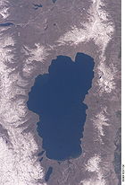
Lake Tahoe is a large freshwater
lake in the Sierra Nevada of the United States. At a surface elevation of 6225 ft (1,897.4 m), it is located along the border between California and Nevada
, west of Carson City
. Lake Tahoe is the largest alpine lake
in North America. Its depth is 1645 ft (501.4 m), making it the USA's second-deepest (the deepest is Crater Lake
in Oregon
, being 300 ft (91.4 m) deeper, at 1945 ft (592.8 m)). Additionally, Lake Tahoe is listed as the 26th largest lake by volume in the world at 122160280 acre.ft.
The lake was formed about 2 million years ago and is a part of the Lake Tahoe Basin with the modern lake being shaped during the ice age
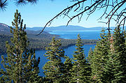
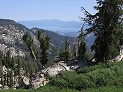
s. It is known for the clarity of its water and the panorama of surrounding mountains on all sides. The area surrounding the lake is also referred to as Lake Tahoe, or simply Tahoe.
Lake Tahoe is a major tourist attraction in both Nevada and California. It is home to a number of ski resorts, summer outdoor recreation, and tourist attraction
s. Snow and skiing are a significant part of the area's economy and reputation. Mountain and lake scenery are attractions throughout the year. The Nevada side also includes large casinos. Highways provide year-round access from Reno
, Carson City, and Sacramento
.
at 1949 ft (594 m). Tahoe is also the 16th deepest lake in the world, and the fifth deepest in average depth. It is about 22 mi (35.4 km) long and 12 mi (19.3 km) wide and has 72 mi (115.9 km) of shoreline and a surface area of 191 square miles (494.7 km²). Washoe Indians used the lake.
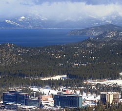
Approximately two-thirds of the shoreline is in California. The south shore is dominated by the lake's largest city, South Lake Tahoe, California
, which adjoins the town of Stateline, Nevada
, while Tahoe City, California
, is located on the lake's northwest shore. Although highways run within sight of the lake shore for much of Tahoe's perimeter, many important parts of the shoreline now lie within state parks or are protected by the United States Forest Service
. The Lake Tahoe Watershed (USGS Huc
18100200) of 505 sq mi (1,307.9 km²) includes the land area that drains to the lake and the Lake Tahoe drainage divide traverses the same general area as the Tahoe Rim Trail
.
 The Lake Tahoe Basin was formed by a geologic block (normal) faulting. A geologic block fault is a fracture in the Earth's crust causing blocks of land to move up or down. Uplifted blocks created the Carson Range
on the east and the Sierra Nevada on the west. Down-dropped blocks (a graben
) created the Lake Tahoe Basin in between.
More technically, Lake Tahoe is the youngest of several extensional basins of the Walker Lane Deformation Belt that accommodates nearly 12 mm/yr of dextral shear between the Sierra Nevada Microplate and North America
. The Lake Tahoe basin is formed by a series of large down-to-the-east normal faults, including the West Tahoe—Dollar Point fault, Stateline/North Tahoe fault and the Incline Village fault. These right-stepping en-echelon faults are capable of large magnitude 7
earthquakes, with the most recent M7 paleoquake (~1500 AD) occurring on the Incline Village fault with nearly 9.7 ft (3 m) of vertical offset. The West Tahoe-Dollar Point Fault (WTDPF) appears to be the most active and potentially hazardous fault in the basin. A study in Fallen Leaf Lake, just south of Lake Tahoe, used seafloor mapping techniques to image evidence for paleoearthquakes on the WTDPF and revealed the last earthquake occurred between 4,100 and 4,500 years ago.
Some of the highest peaks of the Lake Tahoe Basin that formed during the process of Lake Tahoe creation are Freel Peak
at 10891 feet (3,320 m), Monument Peak at 10067 feet (3,068 m), Pyramid Peak
at 9983 feet (3,043 m) (in the Desolation Wilderness
), and Mount Tallac
at 9735 feet (2,967 m). The north shore boasts 3 peaks at 10,000+ feet; Mount Rose, Houghton and Relay peaks. Mt. Rose is a very popular hiking and backcountry skiing destination.
Eruptions from the extinct volcano
Mount Pluto
formed a dam on the north side. Melting snow filled the southern and lowest part of the basin to form the ancestral Lake Tahoe. Rain and runoff added additional water.
Modern Lake Tahoe was shaped and landscaped by scouring glacier
s during the Ice Ages, which began a million or more years ago. Lake Tahoe is fed from 63 tributaries with the Truckee River
as the only outlet. The Truckee flows northeast through Reno, Nevada and into Pyramid Lake, Nevada which has no outlet.
Soils of the basin come primarily from andesitic volcanic rocks and granodiorite
, with minor areas of metamorphic rock
. Some of the valley bottoms and lower hill slopes are mantled with glacial moraine
s, or glacial outwash material derived from the parent rock. Cryopsamments, Cryumbrepts, rockland, rock outcrops and rubble and stony colluvium
account for over 70% of the land area in the basin (see USA soil taxonomy). The basin soils (in the < 2 mm fraction) are generally 65-85% sand (0.05–2.0 mm).
Given the great depth of Lake Tahoe, and the locations of the normal faults within the deepest portions of the lake, modeling suggests that earthquakes on these faults can trigger tsunami
s. Wave heights of these tsunamis are predicted to be on the order of 10 to 33 ft (3 to 10.1 ) in height, capable of traversing the lake in just a few minutes. A massive collapse of the western edge of the basin that formed McKinney Bay around 50,000 years ago is thought to have generated a tsunami/seiche wave
with a height approaching 330 ft (100.6 m).
 Mean annual precipitation ranges from over 55 in (139.7 cm) in watersheds on the west side of the basin to about 26 inches (660 mm) near the lake on the east side of the basin. Most of the precipitation falls as snow between November and April, although rainstorms combined with rapid snow melt account for the largest floods. There is a pronounced annual runoff of snowmelt in late spring and early summer, the timing of which varies from year to year. In some years, summertime monsoon
storms from the Great Basin bring intense rainfall, especially to high elevations on the east side of the basin.
August is normally the warmest month at the Lake Tahoe Airport
(elevation 6254 ft (1,906.2 m)) with an average maximum of 78.7 °F (25.9 °C) and an average minimum of 39.8 °F (4.3 °C). January is the coolest month with an average maximum of 41.0 °F (5.0 °C) and an average minimum of 15.1 °F (−9.4 °C). The all-time maximum of 99 °F (37.2 °C) was recorded on July 22, 1988. The all-time minimum of −29 °F (−33.9 °C) was recorded on December 9, 1972, and February 7, 1989. Temperatures exceed 90 °F (32.2 °C) on an average of 2.0 days annually. Minimum temperatures of 32 °F (0 °C) or lower occur on an average of 231.8 days annually, and minimum temperatures of 0 °F (−17.8 °C) or lower occur on an average of 7.6 days annually. Freezing temperatures have occurred every month of the year.
(Pinus jeffreyi), lodgepole pine
(P. contorta), white fir
(Abies concolor), and red fir
(A. magnifica). The basin also contains significant areas of wet meadow
s and riparian areas, dry meadow
s, brush fields (with Arctostaphylos
and Ceanothus
) and rock outcrop
areas, especially at higher elevations. Ceanothus is capable of fixing nitrogen
, but mountain alder
(Alnus tenuifolia), which grows along many of the basin’s streams, springs and seeps, fixes far greater quantities, and contributes measurably to nitrate-N concentrations in some small streams. The beaches of Lake Tahoe are the only known habitat for the rare Lake Tahoe yellowcress
(Rorippa subumbellata), a plant which grows in the wet sand between low- and high-water marks.
Each autumn, from late September through mid-October, mature kokanee salmon
(Oncorhyncus nerka), transform from silver-blue color to a fiery vermilion, and run up Taylor Creek, near South Lake Tahoe. As spawning season approaches the fish acquire a humpback and protuberant jaw. After spawning they die and their carcasses provide a feast for gatherings of mink
(Neovison vison), bear
s (Ursus americanus), and Bald eagle
s (Haliaeetus leucocephalus). These salmon were transplanted from the North Pacific
to Lake Tahoe in 1944.
North American Beaver (Castor canadensis) were re-introduced to the Tahoe Basin
by the California Department of Fish and Game
(CDFG) and the U.S. Forest Service
between 1934 and 1949. Descended from no more than nine individuals, 1987 beaver populations on the upper and lower Truckee River
had reached a density of 0.72 colonies (3.5 beavers) per kilometer. At the present time beaver have been seen in Tahoe Keys, Meeks Creek at Meeks Bay on the western shore, and King's Beach
on the north shore, so the descendants of the original nine beavers have apparently migrated around most of Lake Tahoe. That beaver were once native to the area is supported by the fact that the Washo
have a word for beaver, c'imhélhel and the northern Paiute of Walker Lake
, Honey Lake
and Pyramid Lake have a word for beaver su-i'-tu-ti-kut'-teh. When Stephen Powers
visited the northern Paiute to collect Indian materials for the Smithsonian Institution
in preparation for the Centennial Exhibition of 1876
, he reported that the northern Paiute wrapped their hair in strips of beaver fur, made medicine from parts of beaver and that their creation legend included beaver.
tribe of Native Americans. Lake Tahoe was the center and heart of Washoe Indian territory, including the upper valleys of the Walker, Carson
and Truckee Rivers. The English name for Lake Tahoe derives from the mispronunciation of the Washo
word “dá’aw," meaning “Lake Tahoe”.
was the first person of European descent to see Lake Tahoe, during Fremont's second exploratory expedition on February 14, 1844. John Calhoun Johnson
, Sierra explorer and founder of "Johnson's Cutoff" (now U.S. Route 50), was the first white man to see Meeks Bay and from a peak above the lake he named Fallen Leaf Lake after his Indian guide. His first job in the west was in the government service, carrying the mail on snowshoes from Placerville
to Nevada City
, during which time he named the lake "Lake Bigler" in honor of California’s third governor John Bigler
. In 1853 William Eddy, the surveyor general of California, identified Tahoe as Lake Bigler. In 1862 the U.S. Department of the Interior first introduced the name Tahoe. Both names were used until well into the next century. The lake didn't receive its official and final designation as Lake Tahoe until 1945.
California and Nevada reached the compromise to partition Tahoe between the two when Nevada became a state in 1864. With the state line east of the approximate centerline of the lake and then at 39 degrees north
latitude, the state border runs southeasterly towards the Colorado River
.
, a silver deposit just 15 miles (24 km) to the east in Virginia City, Nevada
. From 1858 until about 1890, logging in the basin supplied large timbers to shore up the underground workings of the Comstock mines. The logging was so extensive that loggers cut down almost all of the native forest. In 1864, Tahoe City was founded as a resort community for Virginia City, the first recognition of the basin’s potential as a destination resort area.
While Lake Tahoe is a natural lake, it is also used for water storage by the Truckee-Carson Irrigation District
(TCID). The lake level is controlled by a dam built in 1913 at the lake's only outlet, the Truckee River
, at Tahoe City. The 18 feet (5.5 m) high dam can increase the lake's capacity by 744600 acre.ft.
During the first half of the 20th century, development around the lake consisted of a few vacation homes. The post-World War II population and building boom, followed by construction of gambling casinos in the Nevada part of the basin during the mid-1950s, and completion of the interstate highway links for the 1960 Winter Olympics
held at Squaw Valley, resulted in a dramatic increase in development within the basin. From 1960 to 1980, the permanent residential population increased from about 10,000 to greater than 50,000, and the summer population grew from about 10,000 to about 90,000. Since the 1980s, development has slowed due to controls on land use.
).
The Tahoe Regional Planning Agency
(TRPA) is a bi-state compact between California and Nevada, that is charged with environmental protection of the Lake Tahoe Basin through land-use regulation and planning. Schisms between TRPA and local residents lead to the formation of grass-roots organizations that hold firm to strict environmentalism.
built by George Whittel Jr once included nearly 27 miles (43.5 km) of the Nevada shoreline. Vikingsholm
was the original settlement on Emerald Bay
and included an island teahouse and a 38 room home. The Ehrman Mansion is a summer home built by a former Wells Fargo president in Sugar Pine Point and is now a state park.
effluent from the basin, the lake is becoming increasingly eutrophic (having an excessive richness of nutrients), with primary productivity increasing by more than 5% annually, and clarity decreasing at an average rate of 0.25 meters per year. Until the early 1980s, nutrient-limitation studies showed that primary productivity in the lake was nitrogen-limited. Now, after a half-century of accelerated nitrogen input (much of it from direct atmospheric deposition), the lake is phosphorus-limited. Swift concluded that “suspended inorganic sediments and phytoplanktonic algae both contribute significantly to the reduction in clarity, and that suspended particulate matter, rather than dissolved organic matter, are the dominant causes of clarity loss.” The largest source of fine sediment particles to Lake Tahoe is urban stormwater runoff, comprising 72 percent of the total fine sediment particle load. The urban uplands also provide the largest opportunity to reduce fine sediment particle and phosphorus contributions to the lake. According to Sahoo, historic clarity of approximately 30 meters can be achieved with total reduction of approximately 75% from urban sources.
The clarity of Lake Tahoe continues to decrease, although the rate of decrease is slowing. Fine sediment
, much of it resulting from land disturbance in the basin, accounts for about half of the loss in clarity. The year 2010 had a low average Secchi depth, with the depth of 64.4 feet being the second lowest ever recorded (the lowest was 64.1 feet in 1997). It represents a decrease of 3.7 feet from the previous year.
Lake Tahoe is a tributary watershed drainage element within the Truckee River Basin, and its sole outlet is the Truckee River, which continues on to discharge to Pyramid Lake. Because of the sensitivity of Truckee River water quality (involving two protected species, the cui-ui
sucker fish
and the Lahontan cutthroat trout
), this drainage basin has been studied extensively. The primary investigations were stimulated by the U.S. Environmental Protection Agency
, who funded the development of the DSSAM model to analyze water quality below Lake Tahoe.
Lake Tahoe never freezes. Since 1970, it has mixed to a depth of at least 1300 ft (396.2 m) a total of 6 or 7 times. Dissolved oxygen is relatively high from top to bottom. Analysis of the temperature records in Lake Tahoe has shown that the lake warmed (between 1969 and 2002) at an average rate of 0.015 °C per year. The warming is caused primarily by increasing air temperatures, and secondarily by increasing downward long-wave radiation. The warming trend is reducing the frequency of deep mixing in the lake, and may have important effects on water clarity and nutrient cycling.
populations have undergone major changes. In 1963–65, opossum shrimp (Mysis diluviana
) were introduced to enhance the food supply for the introduced Kokanee salmon (Onchorhynchus nerka). The shrimp began feeding on the lake's cladocerans (Daphnia
and Bosmina
), and their populations virtually disappeared by 1971. The shrimp provide a food resource for salmon and trout
, but also compete with juvenile fish for zooplankton. Since the 1970s, the cladoceran populations have somewhat recovered, but not to former levels.
In June 2007, the Angora Fire
burned approximately 3100 acre (1,254.5 ha) throughout the South Lake Tahoe area. While the impact of ash on the lake's ecosystem is predicted to be minimal, the impact of potential future erosion is not yet known.
 Until recently, construction on the banks of the Lake had been largely under the control of wealthy real estate developers. Construction activities have resulted in a clouding of the lake's blue waters. Currently, the Tahoe Regional Planning Agency is regulating construction along the shoreline. (and has won two Federal Supreme Court battles over recent decisions
). These regulations are unpopular with many residents, especially those in the Tahoe Lakefront Homeowners Association.
The League to Save Lake Tahoe (Keep Tahoe Blue) has been an environmental watchdog in the Lake Tahoe Basin for 50 years. Founded when a proposal to build a four-lane highway around the lake—with a bridge over the entrance to Emerald Bay—was proposed in 1957, the League has thwarted poorly designed development projects and environmentally unsound planning. The League embraces responsible and diversified use of the Lake's resources while protecting and restoring its natural attributes.
Since 1980, the Lake Tahoe Interagency Monitoring Program (LTIMP) has been measuring stream discharge and concentrations of nutrients and sediment in up to 10 tributary streams in the Lake Tahoe Basin, California-Nevada. The objectives of the LTIMP are to acquire and disseminate the water quality information necessary to support science-based environmental planning and decision making in the basin. The LTIMP is a cooperative program with support from 12 federal and state agencies with interests in the Tahoe Basin. This data set, together with more recently acquired data on urban runoff water quality, is being used by the Lahontan Regional Water Quality Control Board to develop a program (mandated by the Clean Water Act) to limit the flux of nutrients and fine sediment to the Lake.
UC Davis remains a primary steward of the lake. The UC Davis Tahoe Environmental Research Center is dedicated to research, education and public outreach, and to providing objective scientific information for restoration and sustainable use of the Lake Tahoe Basin. Each year, it produces a well-publicized “State of the Lake” assessment report.
s and casino
s catering to visitors.
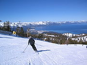
 During ski
season, thousands of people from all over Nevada and California, including Reno
, Las Vegas
, Los Angeles, San Diego, San Francisco, and Sacramento
, flock to the slopes for downhill skiing. Lake Tahoe, in addition to its panoramic beauty, is well known for its blizzard
s.
Some of the major ski areas in Tahoe include:
The majority of the ski resorts in the Lake Tahoe region are on the northern end of the lake, near Truckee, California
and Reno, Nevada. Kirkwood, Sierra-at-Tahoe and Heavenly are located on the southern side of the lake, approximately 80 miles (129 km) from Reno.
Scattered throughout Tahoe are public and private sled
parks. Some, such as Granlibakken are equipped with rope tows to help sledders get up the hill.
Many ski areas around Tahoe also have snow tubing, such as Squaw Valley. Throughout Tahoe, cross-country skiing
, snowmobile
riding and snowshoe
ing are also popular.
 During late Spring to early Fall, the lake is popular for water sports and beach activities. The two cities most identified with the Lake Tahoe tourist area are South Lake Tahoe, California and the smaller Stateline; smaller centers on the northern shoreline include Tahoe City and Kings Beach
.
Other popular activities include parasailing, jet ski rentals and eco-friendly paddle sport rentals. There are rental locations located around Lake Tahoe. Kayaking and stand up paddle boards have also become very popular.
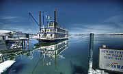
Boating is a primary activity in Tahoe in the summer. There are lake front restaurants all over the lake, most equipped with dock
s and buoys (See the restaurants section). There are all sorts of boating events, such as sailboat racing, firework shows over the lake, guided cruises, and more. As an interstate waterway
, Lake Tahoe is subject to the United States Coast Guard
. Lake Tahoe is home to Coast Guard Station Lake Tahoe.
SCUBA diving
is popular at Lake Tahoe, with some dive sites offering dramatic drop-offs or wall dives. Diving at Lake Tahoe is considered advanced due to the increased risk of decompression sickness
(DCS) while diving
at such a high altitude.
 There are hundreds of hiking and mountain biking trails all around the lake. They range in length, difficulty and popularity. One of the most famous of Tahoe's trails is the Tahoe Rim Trail
, a 165-mile (270-km) trail that circumnavigates the lake. Directly to the west of the lake is the Granite Chief Wilderness, which provides great hiking and wilderness camping. Also, to the southwest is the very popular Desolation Wilderness. One of the most popular trailheads is the Eagle Lake Trailhead. The Flume Trail is one of Mountain Biking Magazine's Top 10 Trails in the US. There are also several paved off-road bicycle paths.
 Gambling is legal on the Nevada side of Lake Tahoe. Casinos, each with a variety of slot machine
s and table game
s, are located on the South Shore in Stateline, and on the North Shore in Crystal Bay and Incline Village.
When Nevada legalized gambling in 1931, the finest casino at the lake had already been open for years. First built on the North Shore in Crystal Bay by Robert Sherman in 1926 , the Calneva cabin became the property of Norman Henry Biltz and was sold to Bill Graham and Jim McKay in 1929.
The Calneva was rebuilt after a fire in 1937 and expanded several times, most noticeably in 1969 when the high-rise hotel was build. Along the way, Frank Sinatra owned the property in the early 1960's, shared his cabins with the likes of Sam Giancana and Marilyn Monroe, and sold out at the height of the area's popularity.
Other casinos at the North Shore include the Crystal Bay Club, first built in 1937 as the Ta-Neva-Ho; the Tahoe Biltmore, and the Nugget. The Hyatt Regency is found at Incline Village.
At South Shore, Bill Harrah purchased the Stateline Country Club which had stood since 1931 and built Harrah's Tahoe. Other casinos include Harvey's, Montbleu, and the Lakeside Inn.
.
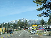 Visitors can reach Lake Tahoe under ideal conditions within two hours from the Sacramento area, one hour from Reno or thirty minutes from Carson City. In winter months, chains or snow tires are often necessary to reach Tahoe from any direction. Traffic can be heavy on weekends due to tourists if not also from weather.
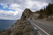
The primary routes to Lake Tahoe are on Interstate 80 via Truckee, U.S. Highway 50, and Nevada Highway 431
via Reno. Most of the highways accessing and encircling Lake Tahoe are paved two-lane mountain roads. US 50 is a four-lane highway passing south of the lake and along part of the eastern shore.
California Highway 89
follows the western shore of the lake through the picturesque wilderness and connects camping, fishing and hiking locations such as those at Emerald Bay State Park, DL Bliss State Park
and Camp Richardson
. Farther along are communities such as Meeks Bay
and Tahoe City. Finally, the highway turns away from the lake and heads northwest toward Truckee.
California Highway 28
completes the circuit from Tahoe City around the northern shore to communities such as Kings Beach, Crystal Bay, and into Incline Village, Nevada where the road becomes Nevada Highway 28
. Highway 28 returns along the eastern shore to US Highway 50 near Spooner Lake.
of the TV series Bonanza
was formerly located on the Nevada side of Lake Tahoe. The opening sequence of the TV series was filmed at the McFaul Creek Meadow, with Mount Tallac
in the background. In September 2004 the Ponderosa Ranch closed its doors, after being sold to developer David Duffield for an undisclosed price.
Lake Tahoe is the second track on the tenth studio album 50 Words for Snow
by English singer-songwriter Kate Bush
, released 21 November 2011.
Smosh
filmed their "The Legend of Zelda Rap [Music Video]" on Lake Tahoe.
of Lake Tahoe groups rivers and creeks that flow into the lake by their locations on the north, east, south and west shores, and lists them in a clock-wise order. Sub-tributaries are listed under the tributaries they feed, sorted by the elevation of the confluence so that tributaries entering nearest Lake Tahoe appear first. Numbers in parentheses are Geographic Names Information System
feature ids.
Incline Creek, Second Creek, Third Creek, and Wood Creek
General Creek, Backwood Creek and Ward Creek
Fresh Water
Fresh Water is the debut album by Australian rock and blues singer Alison McCallum, released in 1972. Rare for an Australian artist at the time, it came in a gatefold sleeve...
lake in the Sierra Nevada of the United States. At a surface elevation of 6225 ft (1,897.4 m), it is located along the border between California and Nevada
Nevada
Nevada is a state in the western, mountain west, and southwestern regions of the United States. With an area of and a population of about 2.7 million, it is the 7th-largest and 35th-most populous state. Over two-thirds of Nevada's people live in the Las Vegas metropolitan area, which contains its...
, west of Carson City
Carson City, Nevada
The Consolidated Municipality of Carson City is the capital of the state of Nevada. The words Consolidated Municipality refer to a series of changes in 1969 which abolished Ormsby County and merged all the settlements contained within its borders into Carson City. Since that time Carson City has...
. Lake Tahoe is the largest alpine lake
Alpine lake
Alpine lakes are classified as lakes or reservoirs at high altitudes, usually starting around 5,000 feet in elevation above sea level or above the tree line....
in North America. Its depth is 1645 ft (501.4 m), making it the USA's second-deepest (the deepest is Crater Lake
Crater Lake
Crater Lake is a caldera lake located in the south-central region of the U.S. state of Oregon. It is the main feature of Crater Lake National Park and famous for its deep blue color and water clarity. The lake partly fills a nearly deep caldera that was formed around 7,700 years agoby the...
in Oregon
Oregon
Oregon is a state in the Pacific Northwest region of the United States. It is located on the Pacific coast, with Washington to the north, California to the south, Nevada on the southeast and Idaho to the east. The Columbia and Snake rivers delineate much of Oregon's northern and eastern...
, being 300 ft (91.4 m) deeper, at 1945 ft (592.8 m)). Additionally, Lake Tahoe is listed as the 26th largest lake by volume in the world at 122160280 acre.ft.
The lake was formed about 2 million years ago and is a part of the Lake Tahoe Basin with the modern lake being shaped during the ice age
Ice age
An ice age or, more precisely, glacial age, is a generic geological period of long-term reduction in the temperature of the Earth's surface and atmosphere, resulting in the presence or expansion of continental ice sheets, polar ice sheets and alpine glaciers...
s. It is known for the clarity of its water and the panorama of surrounding mountains on all sides. The area surrounding the lake is also referred to as Lake Tahoe, or simply Tahoe.
Lake Tahoe is a major tourist attraction in both Nevada and California. It is home to a number of ski resorts, summer outdoor recreation, and tourist attraction
Tourist attraction
A tourist attraction is a place of interest where tourists visit, typically for its inherent or exhibited cultural value, historical significance, natural or built beauty, or amusement opportunities....
s. Snow and skiing are a significant part of the area's economy and reputation. Mountain and lake scenery are attractions throughout the year. The Nevada side also includes large casinos. Highways provide year-round access from Reno
Reno, Nevada
Reno is the county seat of Washoe County, Nevada, United States. The city has a population of about 220,500 and is the most populous Nevada city outside of the Las Vegas metropolitan area...
, Carson City, and Sacramento
Sacramento, California
Sacramento is the capital city of the U.S. state of California and the county seat of Sacramento County. It is located at the confluence of the Sacramento River and the American River in the northern portion of California's expansive Central Valley. With a population of 466,488 at the 2010 census,...
.
Geography
Lake Tahoe is the second deepest lake in the U.S., with a maximum depth of 1645 feet (501 m), trailing only Oregon's Crater LakeCrater Lake
Crater Lake is a caldera lake located in the south-central region of the U.S. state of Oregon. It is the main feature of Crater Lake National Park and famous for its deep blue color and water clarity. The lake partly fills a nearly deep caldera that was formed around 7,700 years agoby the...
at 1949 ft (594 m). Tahoe is also the 16th deepest lake in the world, and the fifth deepest in average depth. It is about 22 mi (35.4 km) long and 12 mi (19.3 km) wide and has 72 mi (115.9 km) of shoreline and a surface area of 191 square miles (494.7 km²). Washoe Indians used the lake.
Approximately two-thirds of the shoreline is in California. The south shore is dominated by the lake's largest city, South Lake Tahoe, California
South Lake Tahoe, California
South Lake Tahoe is the most populous city in El Dorado County, California, in the Sierra Nevada Mountains. The population was 21,403 at the 2010 census, down from 23,609 at the 2000 census...
, which adjoins the town of Stateline, Nevada
Stateline, Nevada
-Demographics:As of the census of 2000, there were 1,215 people, 510 households, and 245 families residing in the CDP. The population density was 1,803.3 people per square mile . There were 562 housing units at an average density of 834.1 per square mile...
, while Tahoe City, California
Tahoe City, California
Tahoe City is an unincorporated community in Placer County, California. Tahoe City is located on Lake Tahoe, southeast of Donner Pass. It lies at an elevation of 6250 feet ....
, is located on the lake's northwest shore. Although highways run within sight of the lake shore for much of Tahoe's perimeter, many important parts of the shoreline now lie within state parks or are protected by the United States Forest Service
United States Forest Service
The United States Forest Service is an agency of the United States Department of Agriculture that administers the nation's 155 national forests and 20 national grasslands, which encompass...
. The Lake Tahoe Watershed (USGS Huc
Hydrological code
A hydrological code or hydrologic unit code is a sequence of numbers or letters that identify a hydrological feature like a river, river reach, lake, or area like a drainage basin ....
18100200) of 505 sq mi (1,307.9 km²) includes the land area that drains to the lake and the Lake Tahoe drainage divide traverses the same general area as the Tahoe Rim Trail
Tahoe Rim Trail
The Tahoe Rim Trail is a 165-mile long-distance hiking trail which forms a loop around Lake Tahoe in the Sierra Nevada and Carson ranges of California and Nevada in the United States. The trail ranges in elevation from 6,240 feet at the outlet of Lake Tahoe to 10,338 feet at Relay Peak in Nevada...
.
Geology
Carson Range
The Carson Range is a spur of the Sierra Nevada in eastern California and western Nevada that starts at Luther Pass and West Carson Canyon and goes to the Truckee River...
on the east and the Sierra Nevada on the west. Down-dropped blocks (a graben
Graben
In geology, a graben is a depressed block of land bordered by parallel faults. Graben is German for ditch. Graben is used for both the singular and plural....
) created the Lake Tahoe Basin in between.
More technically, Lake Tahoe is the youngest of several extensional basins of the Walker Lane Deformation Belt that accommodates nearly 12 mm/yr of dextral shear between the Sierra Nevada Microplate and North America
North American Plate
The North American Plate is a tectonic plate covering most of North America, Greenland, Cuba, Bahamas, and parts of Siberia, Japan and Iceland. It extends eastward to the Mid-Atlantic Ridge and westward to the Chersky Range in eastern Siberia. The plate includes both continental and oceanic crust...
. The Lake Tahoe basin is formed by a series of large down-to-the-east normal faults, including the West Tahoe—Dollar Point fault, Stateline/North Tahoe fault and the Incline Village fault. These right-stepping en-echelon faults are capable of large magnitude 7
Richter magnitude scale
The expression Richter magnitude scale refers to a number of ways to assign a single number to quantify the energy contained in an earthquake....
earthquakes, with the most recent M7 paleoquake (~1500 AD) occurring on the Incline Village fault with nearly 9.7 ft (3 m) of vertical offset. The West Tahoe-Dollar Point Fault (WTDPF) appears to be the most active and potentially hazardous fault in the basin. A study in Fallen Leaf Lake, just south of Lake Tahoe, used seafloor mapping techniques to image evidence for paleoearthquakes on the WTDPF and revealed the last earthquake occurred between 4,100 and 4,500 years ago.
Some of the highest peaks of the Lake Tahoe Basin that formed during the process of Lake Tahoe creation are Freel Peak
Freel Peak
Freel Peak is a mountain located in the Carson Range, a spur of the Sierra Nevada, near Lake Tahoe in California. The peak is on the boundary between El Dorado County and Alpine County; and the boundary between the Eldorado National Forest and the Humboldt-Toiyabe National Forest.At it is the...
at 10891 feet (3,320 m), Monument Peak at 10067 feet (3,068 m), Pyramid Peak
Pyramid Peak (California)
Pyramid Peak is a mountain in the California's Sierra Nevada within the Crystal Range and to the west of Lake Tahoe. It is the highest point in the Desolation Wilderness. With an elevation gain of almost , the Rocky Canyon route is the mountain's most popular approach although it is very arduous....
at 9983 feet (3,043 m) (in the Desolation Wilderness
Desolation Wilderness
The Desolation Wilderness is a federally protected wilderness area located along the crest of the Sierra Nevada mountain range, just southwest of Lake Tahoe in El Dorado County, California, United States. It is a popular backpacking destination, with much barren rocky terrain at the edge of the...
), and Mount Tallac
Mount Tallac
Mount Tallac is a mountain peak southwest of Lake Tahoe, in El Dorado County, California. The peak lies within the Desolation Wilderness on the Eldorado National Forest. It is quite visible from State Route 89...
at 9735 feet (2,967 m). The north shore boasts 3 peaks at 10,000+ feet; Mount Rose, Houghton and Relay peaks. Mt. Rose is a very popular hiking and backcountry skiing destination.
Eruptions from the extinct volcano
Volcano
2. Bedrock3. Conduit 4. Base5. Sill6. Dike7. Layers of ash emitted by the volcano8. Flank| 9. Layers of lava emitted by the volcano10. Throat11. Parasitic cone12. Lava flow13. Vent14. Crater15...
Mount Pluto
Mount Pluto, California
Mount Pluto is an extinct volcano in the Granite Chief Range near Lake Tahoe, California. The volcano erupted approximately 2 million years ago producing lava and mudflows that dammed Lake Tahoe. The Northstar at Tahoe ski resort covers part of the high peak....
formed a dam on the north side. Melting snow filled the southern and lowest part of the basin to form the ancestral Lake Tahoe. Rain and runoff added additional water.
Modern Lake Tahoe was shaped and landscaped by scouring glacier
Glacier
A glacier is a large persistent body of ice that forms where the accumulation of snow exceeds its ablation over many years, often centuries. At least 0.1 km² in area and 50 m thick, but often much larger, a glacier slowly deforms and flows due to stresses induced by its weight...
s during the Ice Ages, which began a million or more years ago. Lake Tahoe is fed from 63 tributaries with the Truckee River
Truckee River
The Truckee River is a stream in the U.S. states of California and Nevada. The river is about long. Its endorheic drainage basin is about , of which about are in Nevada. The Truckee is the sole outlet of Lake Tahoe and drains part of the high Sierra Nevada, emptying into Pyramid Lake in the Great...
as the only outlet. The Truckee flows northeast through Reno, Nevada and into Pyramid Lake, Nevada which has no outlet.
Soils of the basin come primarily from andesitic volcanic rocks and granodiorite
Granodiorite
Granodiorite is an intrusive igneous rock similar to granite, but containing more plagioclase than orthoclase-type feldspar. Officially, it is defined as a phaneritic igneous rock with greater than 20% quartz by volume where at least 65% of the feldspar is plagioclase. It usually contains abundant...
, with minor areas of metamorphic rock
Metamorphic rock
Metamorphic rock is the transformation of an existing rock type, the protolith, in a process called metamorphism, which means "change in form". The protolith is subjected to heat and pressure causing profound physical and/or chemical change...
. Some of the valley bottoms and lower hill slopes are mantled with glacial moraine
Moraine
A moraine is any glacially formed accumulation of unconsolidated glacial debris which can occur in currently glaciated and formerly glaciated regions, such as those areas acted upon by a past glacial maximum. This debris may have been plucked off a valley floor as a glacier advanced or it may have...
s, or glacial outwash material derived from the parent rock. Cryopsamments, Cryumbrepts, rockland, rock outcrops and rubble and stony colluvium
Colluvium
Colluvium is the name for loose bodies of sediment that have been deposited or built up at the bottom of a low-grade slope or against a barrier on that slope, transported by gravity. The deposits that collect at the foot of a steep slope or cliff are also known by the same name. Colluvium often...
account for over 70% of the land area in the basin (see USA soil taxonomy). The basin soils (in the < 2 mm fraction) are generally 65-85% sand (0.05–2.0 mm).
Given the great depth of Lake Tahoe, and the locations of the normal faults within the deepest portions of the lake, modeling suggests that earthquakes on these faults can trigger tsunami
Tsunami
A tsunami is a series of water waves caused by the displacement of a large volume of a body of water, typically an ocean or a large lake...
s. Wave heights of these tsunamis are predicted to be on the order of 10 to 33 ft (3 to 10.1 ) in height, capable of traversing the lake in just a few minutes. A massive collapse of the western edge of the basin that formed McKinney Bay around 50,000 years ago is thought to have generated a tsunami/seiche wave
Seiche
A seiche is a standing wave in an enclosed or partially enclosed body of water. Seiches and seiche-related phenomena have been observed on lakes, reservoirs, swimming pools, bays, harbors and seas...
with a height approaching 330 ft (100.6 m).
Climate
Monsoon
Monsoon is traditionally defined as a seasonal reversing wind accompanied by corresponding changes in precipitation, but is now used to describe seasonal changes in atmospheric circulation and precipitation associated with the asymmetric heating of land and sea...
storms from the Great Basin bring intense rainfall, especially to high elevations on the east side of the basin.
August is normally the warmest month at the Lake Tahoe Airport
Lake Tahoe Airport
Lake Tahoe Airport is a public airport located three miles southwest of South Lake Tahoe, serving El Dorado County, California, USA. This general aviation airport covers and has one runway. The airport is sometimes called Tahoe Valley Airport.The airport formerly offered commercial to several...
(elevation 6254 ft (1,906.2 m)) with an average maximum of 78.7 °F (25.9 °C) and an average minimum of 39.8 °F (4.3 °C). January is the coolest month with an average maximum of 41.0 °F (5.0 °C) and an average minimum of 15.1 °F (−9.4 °C). The all-time maximum of 99 °F (37.2 °C) was recorded on July 22, 1988. The all-time minimum of −29 °F (−33.9 °C) was recorded on December 9, 1972, and February 7, 1989. Temperatures exceed 90 °F (32.2 °C) on an average of 2.0 days annually. Minimum temperatures of 32 °F (0 °C) or lower occur on an average of 231.8 days annually, and minimum temperatures of 0 °F (−17.8 °C) or lower occur on an average of 7.6 days annually. Freezing temperatures have occurred every month of the year.
Ecology
Vegetation in the basin is dominated by a mixed conifer forest of Jeffrey pineJeffrey Pine
The Jeffrey Pine, Pinus jeffreyi, named in honor of its botanist documenter John Jeffrey, is a North American pine related to Ponderosa Pine.-Distribution and habitat:...
(Pinus jeffreyi), lodgepole pine
Lodgepole Pine
Lodgepole Pine, Pinus contorta, also known as Shore Pine, is a common tree in western North America. Like all pines, it is evergreen.-Subspecies:...
(P. contorta), white fir
White Fir
White Fir is a fir native to the mountains of western North America, occurring at altitudes of 900-3,400 m. It is a medium to large evergreen coniferous tree growing to 25–60 m tall and with a trunk diameter of up to 2 m . It is popular as an ornamental landscaping tree and as a Christmas Tree...
(Abies concolor), and red fir
Red Fir
Abies magnifica, the Red Fir or Silvertip fir, is a western North American fir, native to the mountains of southwest Oregon and California in the United States. It is a high altitude tree, typically occurring at altitude, though only rarely reaching tree line...
(A. magnifica). The basin also contains significant areas of wet meadow
Wet meadow
A wet meadow is a semi-wetland meadow which is saturated with water throughout much of the year. Wet meadows may occur because of poor drainage or the receipt of large amounts of water from rain or melted snow. They may also occur in riparian zones....
s and riparian areas, dry meadow
Meadow
A meadow is a field vegetated primarily by grass and other non-woody plants . The term is from Old English mædwe. In agriculture a meadow is grassland which is not grazed by domestic livestock but rather allowed to grow unchecked in order to make hay...
s, brush fields (with Arctostaphylos
Arctostaphylos
Arctostaphylos is a genus of plants comprised by the manzanitas and bearberries. They are shrubs or small trees.There are about 60 species of Arctostaphylos, ranging from ground-hugging arctic, coastal, and mountain species to small trees up to 6 m tall. Most are evergreen , with small oval...
and Ceanothus
Ceanothus
Ceanothus L. is a genus of about 50–60 species of shrubs or small trees in the buckthorn family Rhamnaceae. The genus is confined to North America, the center of its distribution in California, with some species in the eastern United States and southeast Canada, and others extending as far south...
) and rock outcrop
Outcrop
An outcrop is a visible exposure of bedrock or ancient superficial deposits on the surface of the Earth. -Features:Outcrops do not cover the majority of the Earth's land surface because in most places the bedrock or superficial deposits are covered by a mantle of soil and vegetation and cannot be...
areas, especially at higher elevations. Ceanothus is capable of fixing nitrogen
Nitrogen fixation
Nitrogen fixation is the natural process, either biological or abiotic, by which nitrogen in the atmosphere is converted into ammonia . This process is essential for life because fixed nitrogen is required to biosynthesize the basic building blocks of life, e.g., nucleotides for DNA and RNA and...
, but mountain alder
Grey Alder
Alnus incana is a species of alder with a wide range across the cooler parts of the Northern Hemisphere....
(Alnus tenuifolia), which grows along many of the basin’s streams, springs and seeps, fixes far greater quantities, and contributes measurably to nitrate-N concentrations in some small streams. The beaches of Lake Tahoe are the only known habitat for the rare Lake Tahoe yellowcress
Rorippa subumbellata
Rorippa subumbellata is a rare species of flowering plant in the mustard family known by the common name Lake Tahoe yellowcress. It is known only from the shores of Lake Tahoe, straddling the border between California and Nevada. There are an estimated fourteen populations of the plant still in...
(Rorippa subumbellata), a plant which grows in the wet sand between low- and high-water marks.
Each autumn, from late September through mid-October, mature kokanee salmon
Sockeye salmon
Sockeye salmon , also called red salmon or blueback salmon in the USA, is an anadromous species of salmon found in the Northern Pacific Ocean and rivers discharging into it...
(Oncorhyncus nerka), transform from silver-blue color to a fiery vermilion, and run up Taylor Creek, near South Lake Tahoe. As spawning season approaches the fish acquire a humpback and protuberant jaw. After spawning they die and their carcasses provide a feast for gatherings of mink
American Mink
The American mink is a semi-aquatic species of Mustelid native to North America, though human intervention has expanded its range to many parts of Europe and South America. Because of this, it is classed as Least Concern by the IUCN. Since the extinction of the sea mink, the American mink is the...
(Neovison vison), bear
American black bear
The American black bear is a medium-sized bear native to North America. It is the continent's smallest and most common bear species. Black bears are omnivores, with their diets varying greatly depending on season and location. They typically live in largely forested areas, but do leave forests in...
s (Ursus americanus), and Bald eagle
Bald Eagle
The Bald Eagle is a bird of prey found in North America. It is the national bird and symbol of the United States of America. This sea eagle has two known sub-species and forms a species pair with the White-tailed Eagle...
s (Haliaeetus leucocephalus). These salmon were transplanted from the North Pacific
Pacific Ocean
The Pacific Ocean is the largest of the Earth's oceanic divisions. It extends from the Arctic in the north to the Southern Ocean in the south, bounded by Asia and Australia in the west, and the Americas in the east.At 165.2 million square kilometres in area, this largest division of the World...
to Lake Tahoe in 1944.
North American Beaver (Castor canadensis) were re-introduced to the Tahoe Basin
Beaver in the Sierra Nevada
The North American beaver had a historic range that overlapped the Sierra Nevada in California. Before the European colonization of the Americas, beaver were distributed from the arctic tundra to the deserts of northern Mexico...
by the California Department of Fish and Game
California Department of Fish and Game
The California Department of Fish and Game is a department within the government of California, falling under its parent California Natural Resources Agency. The Department of Fish and Game manages and protects the state's diverse fish, wildlife, plant resources, and native habitats...
(CDFG) and the U.S. Forest Service
United States Forest Service
The United States Forest Service is an agency of the United States Department of Agriculture that administers the nation's 155 national forests and 20 national grasslands, which encompass...
between 1934 and 1949. Descended from no more than nine individuals, 1987 beaver populations on the upper and lower Truckee River
Truckee River
The Truckee River is a stream in the U.S. states of California and Nevada. The river is about long. Its endorheic drainage basin is about , of which about are in Nevada. The Truckee is the sole outlet of Lake Tahoe and drains part of the high Sierra Nevada, emptying into Pyramid Lake in the Great...
had reached a density of 0.72 colonies (3.5 beavers) per kilometer. At the present time beaver have been seen in Tahoe Keys, Meeks Creek at Meeks Bay on the western shore, and King's Beach
Kings Beach, California
Kings Beach is a census-designated place in Placer County, California, United States on the north shore of Lake Tahoe. It is part of the Sacramento–Arden-Arcade–Roseville Metropolitan Statistical Area. The population was 3,796 at the 2010 census, down from 4,037 at the 2000 census.The...
on the north shore, so the descendants of the original nine beavers have apparently migrated around most of Lake Tahoe. That beaver were once native to the area is supported by the fact that the Washo
Washoe people
The Washoe are a Great Basin tribe of Native Americans, living in California and Nevada. The name "Washoe" is derived from the autonym waashiw meaning "people from here" in the Washo language .-Territory:Washoe people have lived in the Great Basin for at least the last 6000 years...
have a word for beaver, c'imhélhel and the northern Paiute of Walker Lake
Walker Lake (Nevada)
Walker Lake is a natural lake, 50.3 mi² in area, in the Great Basin in western Nevada in the United States. It is 18 mi long and 7 mi wide, located in northwestern Mineral County along the eastern side of the Wassuk Range, approximately 75 mi southeast of Reno...
, Honey Lake
Honey Lake
Honey Lake is an endorheic sink within the Honey Lake Valley located in northeastern California, near the Nevada border. Summer evaporation reduces the lake to a lower level of 12 km² and creates an alkali flat....
and Pyramid Lake have a word for beaver su-i'-tu-ti-kut'-teh. When Stephen Powers
Stephen Powers
*This article is about the 19th-century journalist and historian of California Indians.Stephen Powers was an American journalist, ethnographer, and historian of Native American tribes in California. He traveled extensively to study and learn about their cultures, and wrote notable accounts of them...
visited the northern Paiute to collect Indian materials for the Smithsonian Institution
Smithsonian Institution
The Smithsonian Institution is an educational and research institute and associated museum complex, administered and funded by the government of the United States and by funds from its endowment, contributions, and profits from its retail operations, concessions, licensing activities, and magazines...
in preparation for the Centennial Exhibition of 1876
Centennial Exposition
The Centennial International Exhibition of 1876, the first official World's Fair in the United States, was held in Philadelphia, Pennsylvania, from May 10 to November 10, 1876, to celebrate the 100th anniversary of the signing of the Declaration of Independence in Philadelphia. It was officially...
, he reported that the northern Paiute wrapped their hair in strips of beaver fur, made medicine from parts of beaver and that their creation legend included beaver.
Native people
The area around Lake Tahoe was originally inhabited by the WashoeWashoe people
The Washoe are a Great Basin tribe of Native Americans, living in California and Nevada. The name "Washoe" is derived from the autonym waashiw meaning "people from here" in the Washo language .-Territory:Washoe people have lived in the Great Basin for at least the last 6000 years...
tribe of Native Americans. Lake Tahoe was the center and heart of Washoe Indian territory, including the upper valleys of the Walker, Carson
Carson River
The Carson River is a northwestern Nevada river that empties into the Carson Sink, an endorheic basin. The main stem of the river is long....
and Truckee Rivers. The English name for Lake Tahoe derives from the mispronunciation of the Washo
Washo language
The Washo language is an endangered Native American language isolate spoken by the Washo on the California–Nevada border in the drainages of the Truckee and Carson Rivers, especially around Lake Tahoe...
word “dá’aw," meaning “Lake Tahoe”.
Exploration
Lt. John C. FrémontJohn C. Frémont
John Charles Frémont , was an American military officer, explorer, and the first candidate of the anti-slavery Republican Party for the office of President of the United States. During the 1840s, that era's penny press accorded Frémont the sobriquet The Pathfinder...
was the first person of European descent to see Lake Tahoe, during Fremont's second exploratory expedition on February 14, 1844. John Calhoun Johnson
John Calhoun Johnson
John Calhoun Johnson was a native of Deersville, Ohio, who practiced law and operated a ranch in California.Johnson crossed the plains with ox teams in the spring of 1848...
, Sierra explorer and founder of "Johnson's Cutoff" (now U.S. Route 50), was the first white man to see Meeks Bay and from a peak above the lake he named Fallen Leaf Lake after his Indian guide. His first job in the west was in the government service, carrying the mail on snowshoes from Placerville
Placerville, California
Placerville is the county seat of El Dorado County, California. The population was 10,389 at the 2010 census, up from 9,610 at the 2000 census. It is part of the Sacramento–Arden-Arcade–Roseville Metropolitan Statistical Area.-Geography:...
to Nevada City
Nevada City, California
-2010:The 2010 United States Census reported that Nevada City had a population of 3,068. The population density was 1,399.7 people per square mile . The racial makeup of Nevada City was 2,837 White, 26 African American, 28 Native American, 46 Asian, 0 Pacific Islander, 40 from other races,...
, during which time he named the lake "Lake Bigler" in honor of California’s third governor John Bigler
John Bigler
John Bigler was an American lawyer, politician and diplomat. A Democrat, he served as the third Governor of California from 1852 to 1856 and was the first California governor to complete an entire term in office successfully, as well as the first to win re-election...
. In 1853 William Eddy, the surveyor general of California, identified Tahoe as Lake Bigler. In 1862 the U.S. Department of the Interior first introduced the name Tahoe. Both names were used until well into the next century. The lake didn't receive its official and final designation as Lake Tahoe until 1945.
California and Nevada reached the compromise to partition Tahoe between the two when Nevada became a state in 1864. With the state line east of the approximate centerline of the lake and then at 39 degrees north
39th parallel north
The 39th parallel north is a circle of latitude that is 39 degrees north of the Earth's equatorial plane. It crosses Europe, the Mediterranean Sea, Asia, the Pacific Ocean, North America, and the Atlantic Ocean....
latitude, the state border runs southeasterly towards the Colorado River
Colorado River
The Colorado River , is a river in the Southwestern United States and northwestern Mexico, approximately long, draining a part of the arid regions on the western slope of the Rocky Mountains. The watershed of the Colorado River covers in parts of seven U.S. states and two Mexican states...
.
Mining era
Upon discovery of gold in the South Fork of the American River in 1848, thousands of gold seekers going west passed near the basin on their way to the gold fields. European civilization first made its mark in the Lake Tahoe basin with the 1858 discovery of the Comstock LodeComstock Lode
The Comstock Lode was the first major U.S. discovery of silver ore, located under what is now Virginia City, Nevada, on the eastern slope of Mount Davidson, a peak in the Virginia Range. After the discovery was made public in 1859, prospectors rushed to the area and scrambled to stake their claims...
, a silver deposit just 15 miles (24 km) to the east in Virginia City, Nevada
Virginia City, Nevada
Virginia City is a census-designated place that is the county seat of Storey County, Nevada. It is part of the Reno–Sparks Metropolitan Statistical Area. The population was 855 at the 2010 Census.- History :...
. From 1858 until about 1890, logging in the basin supplied large timbers to shore up the underground workings of the Comstock mines. The logging was so extensive that loggers cut down almost all of the native forest. In 1864, Tahoe City was founded as a resort community for Virginia City, the first recognition of the basin’s potential as a destination resort area.
Development
Public appreciation of the Tahoe basin grew, and during the 1912, 1913 and 1918 congressional sessions, congressmen tried unsuccessfully to designate the basin as a national park.While Lake Tahoe is a natural lake, it is also used for water storage by the Truckee-Carson Irrigation District
Truckee-Carson Irrigation District
The Truckee-Carson Irrigation District is a political subdivision of the State of Nevada, which operates dams at Lake Tahoe, on the Truckee River and Lake Lahontan as well as of canals and of drains in support of agriculture in Lyon County and Churchill County.Diversion of water by the TCID from...
(TCID). The lake level is controlled by a dam built in 1913 at the lake's only outlet, the Truckee River
Truckee River
The Truckee River is a stream in the U.S. states of California and Nevada. The river is about long. Its endorheic drainage basin is about , of which about are in Nevada. The Truckee is the sole outlet of Lake Tahoe and drains part of the high Sierra Nevada, emptying into Pyramid Lake in the Great...
, at Tahoe City. The 18 feet (5.5 m) high dam can increase the lake's capacity by 744600 acre.ft.
During the first half of the 20th century, development around the lake consisted of a few vacation homes. The post-World War II population and building boom, followed by construction of gambling casinos in the Nevada part of the basin during the mid-1950s, and completion of the interstate highway links for the 1960 Winter Olympics
1960 Winter Olympics
The 1960 Winter Olympics, officially known as the VIII Olympic Winter Games, were a winter multi-sport event held between February 18 and 28, 1960 in Squaw Valley, California, United States. In 1955 at the 50th IOC meeting, the organizing committee made the surprise choice to award Squaw Valley as...
held at Squaw Valley, resulted in a dramatic increase in development within the basin. From 1960 to 1980, the permanent residential population increased from about 10,000 to greater than 50,000, and the summer population grew from about 10,000 to about 90,000. Since the 1980s, development has slowed due to controls on land use.
Government and politics
Lake Tahoe lies within the borders of both California and Nevada, and as such is not governed by any single entity. In California, Lake Tahoe is divided between Placer County and El Dorado County. In Nevada, Lake Tahoe is divided among Washoe County, Douglas County and Carson City (an independent cityIndependent city
An independent city is a city that does not form part of another general-purpose local government entity. These type of cities should not be confused with city-states , which are fully sovereign cities that are not part of any other sovereign state.-Historical precursors:In the Holy Roman Empire,...
).
The Tahoe Regional Planning Agency
Tahoe Regional Planning Agency
The Tahoe Regional Planning Agency was formed in 1969 through a bi-state compact between California and Nevada which was ratified by the U.S. Congress...
(TRPA) is a bi-state compact between California and Nevada, that is charged with environmental protection of the Lake Tahoe Basin through land-use regulation and planning. Schisms between TRPA and local residents lead to the formation of grass-roots organizations that hold firm to strict environmentalism.
Mansions
Lake Tahoe is also the location of several 19th and 20th century palatial homes of historical significance. The Thunderbird LodgeThunderbird Lodge (Lake Tahoe, Nevada)
The Thunderbird Lodge is a waterfront estate located on the east shore of Lake Tahoe. It was built in 1939 as the summer home of George Whittell Jr., an heir to one of San Francisco's wealthiest families...
built by George Whittel Jr once included nearly 27 miles (43.5 km) of the Nevada shoreline. Vikingsholm
Vikingsholm
Vikingsholm is a 38-room mansion on the shore of Emerald Bay at Lake Tahoe, in El Dorado County, California, U.S., and on the National Register of Historic Places-History:...
was the original settlement on Emerald Bay
Emerald Bay, El Dorado County, California
Emerald Bay is an unincorporated community in El Dorado County, California. It lies at an elevation of 6319 feet ....
and included an island teahouse and a 38 room home. The Ehrman Mansion is a summer home built by a former Wells Fargo president in Sugar Pine Point and is now a state park.
Water quality
In spite of land-use planning and export of treated sewageSewage
Sewage is water-carried waste, in solution or suspension, that is intended to be removed from a community. Also known as wastewater, it is more than 99% water and is characterized by volume or rate of flow, physical condition, chemical constituents and the bacteriological organisms that it contains...
effluent from the basin, the lake is becoming increasingly eutrophic (having an excessive richness of nutrients), with primary productivity increasing by more than 5% annually, and clarity decreasing at an average rate of 0.25 meters per year. Until the early 1980s, nutrient-limitation studies showed that primary productivity in the lake was nitrogen-limited. Now, after a half-century of accelerated nitrogen input (much of it from direct atmospheric deposition), the lake is phosphorus-limited. Swift concluded that “suspended inorganic sediments and phytoplanktonic algae both contribute significantly to the reduction in clarity, and that suspended particulate matter, rather than dissolved organic matter, are the dominant causes of clarity loss.” The largest source of fine sediment particles to Lake Tahoe is urban stormwater runoff, comprising 72 percent of the total fine sediment particle load. The urban uplands also provide the largest opportunity to reduce fine sediment particle and phosphorus contributions to the lake. According to Sahoo, historic clarity of approximately 30 meters can be achieved with total reduction of approximately 75% from urban sources.
The clarity of Lake Tahoe continues to decrease, although the rate of decrease is slowing. Fine sediment
Sediment
Sediment is naturally occurring material that is broken down by processes of weathering and erosion, and is subsequently transported by the action of fluids such as wind, water, or ice, and/or by the force of gravity acting on the particle itself....
, much of it resulting from land disturbance in the basin, accounts for about half of the loss in clarity. The year 2010 had a low average Secchi depth, with the depth of 64.4 feet being the second lowest ever recorded (the lowest was 64.1 feet in 1997). It represents a decrease of 3.7 feet from the previous year.
Lake Tahoe is a tributary watershed drainage element within the Truckee River Basin, and its sole outlet is the Truckee River, which continues on to discharge to Pyramid Lake. Because of the sensitivity of Truckee River water quality (involving two protected species, the cui-ui
Cui-ui
The cui-ui, Chasmistes cujus, is a large sucker fish endemic to Pyramid Lake and, prior to its desiccation in the 20th century, Winnemucca Lake in northwestern Nevada. It feeds primarily on zooplankton and possibly on nanoplankton...
sucker fish
Catostomidae
Catostomidae is the sucker family of the order Cypriniformes. There are 80 species in this family of freshwater fishes. Catostomidae are found in North America, east central China, and eastern Siberia...
and the Lahontan cutthroat trout
Lahontan cutthroat trout
Lahontan cutthroat trout is the largest subspecies of cutthroat trout, and the state fish of Nevada.-Natural history:...
), this drainage basin has been studied extensively. The primary investigations were stimulated by the U.S. Environmental Protection Agency
United States Environmental Protection Agency
The U.S. Environmental Protection Agency is an agency of the federal government of the United States charged with protecting human health and the environment, by writing and enforcing regulations based on laws passed by Congress...
, who funded the development of the DSSAM model to analyze water quality below Lake Tahoe.
Lake Tahoe never freezes. Since 1970, it has mixed to a depth of at least 1300 ft (396.2 m) a total of 6 or 7 times. Dissolved oxygen is relatively high from top to bottom. Analysis of the temperature records in Lake Tahoe has shown that the lake warmed (between 1969 and 2002) at an average rate of 0.015 °C per year. The warming is caused primarily by increasing air temperatures, and secondarily by increasing downward long-wave radiation. The warming trend is reducing the frequency of deep mixing in the lake, and may have important effects on water clarity and nutrient cycling.
Ecosystem changes
Since the 1960s, the Lake's food web and zooplanktonZooplankton
Zooplankton are heterotrophic plankton. Plankton are organisms drifting in oceans, seas, and bodies of fresh water. The word "zooplankton" is derived from the Greek zoon , meaning "animal", and , meaning "wanderer" or "drifter"...
populations have undergone major changes. In 1963–65, opossum shrimp (Mysis diluviana
Mysis diluviana
Mysis diluviana is a mysid crustacean that inhabits freshwater lakes of northern North America.-Appearance:Mysis is a small, transparent shrimp-like crustacean, of less than length...
) were introduced to enhance the food supply for the introduced Kokanee salmon (Onchorhynchus nerka). The shrimp began feeding on the lake's cladocerans (Daphnia
Daphnia
Daphnia are small, planktonic crustaceans, between 0.2 and 5 mm in length. Daphnia are members of the order Cladocera, and are one of the several small aquatic crustaceans commonly called water fleas because of their saltatory swimming style...
and Bosmina
Bosmina
Bosmina is a genus in the order Cladocera. Its members can be distinguished from those of Bosminopsis by the separation of the antennae; in Bosminopsis, the antennae are fused at their bases....
), and their populations virtually disappeared by 1971. The shrimp provide a food resource for salmon and trout
Trout
Trout is the name for a number of species of freshwater and saltwater fish belonging to the Salmoninae subfamily of the family Salmonidae. Salmon belong to the same family as trout. Most salmon species spend almost all their lives in salt water...
, but also compete with juvenile fish for zooplankton. Since the 1970s, the cladoceran populations have somewhat recovered, but not to former levels.
In June 2007, the Angora Fire
Angora Fire
The Angora Fire was a wind driven fire that started near North Upper Truckee Road subdivision near Angora Lakes, Fallen Leaf Lake, Echo Lake and South Lake Tahoe, California around 2:15 PM on Sunday, June 24, 2007 as a result of an illegal campfire. As of July 2, 2007, the fire was 100%...
burned approximately 3100 acre (1,254.5 ha) throughout the South Lake Tahoe area. While the impact of ash on the lake's ecosystem is predicted to be minimal, the impact of potential future erosion is not yet known.
Environmental protection
Tahoe-Sierra Preservation Council, Inc. v. Tahoe Regional Planning Agency
Tahoe-Sierra Preservation Council, Inc. v. Tahoe Regional Planning Agency, 535 U.S. 302 , is one of the United States Supreme Court's more recent interpretations of the Takings Clause of the Fifth and Fourteenth Amendments....
). These regulations are unpopular with many residents, especially those in the Tahoe Lakefront Homeowners Association.
The League to Save Lake Tahoe (Keep Tahoe Blue) has been an environmental watchdog in the Lake Tahoe Basin for 50 years. Founded when a proposal to build a four-lane highway around the lake—with a bridge over the entrance to Emerald Bay—was proposed in 1957, the League has thwarted poorly designed development projects and environmentally unsound planning. The League embraces responsible and diversified use of the Lake's resources while protecting and restoring its natural attributes.
Since 1980, the Lake Tahoe Interagency Monitoring Program (LTIMP) has been measuring stream discharge and concentrations of nutrients and sediment in up to 10 tributary streams in the Lake Tahoe Basin, California-Nevada. The objectives of the LTIMP are to acquire and disseminate the water quality information necessary to support science-based environmental planning and decision making in the basin. The LTIMP is a cooperative program with support from 12 federal and state agencies with interests in the Tahoe Basin. This data set, together with more recently acquired data on urban runoff water quality, is being used by the Lahontan Regional Water Quality Control Board to develop a program (mandated by the Clean Water Act) to limit the flux of nutrients and fine sediment to the Lake.
UC Davis remains a primary steward of the lake. The UC Davis Tahoe Environmental Research Center is dedicated to research, education and public outreach, and to providing objective scientific information for restoration and sustainable use of the Lake Tahoe Basin. Each year, it produces a well-publicized “State of the Lake” assessment report.
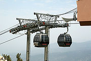
Tourist activities
Much of the area surrounding Lake Tahoe is devoted to the tourism industry and there are many restaurants, ski slopes, golf courseGolf course
A golf course comprises a series of holes, each consisting of a teeing ground, fairway, rough and other hazards, and a green with a flagstick and cup, all designed for the game of golf. A standard round of golf consists of playing 18 holes, thus most golf courses have this number of holes...
s and casino
Casino
In modern English, a casino is a facility which houses and accommodates certain types of gambling activities. Casinos are most commonly built near or combined with hotels, restaurants, retail shopping, cruise ships or other tourist attractions...
s catering to visitors.
Winter sports
Ski
A ski is a long, flat device worn on the foot, usually attached through a boot, designed to help the wearer slide smoothly over snow. Originally intended as an aid to travel in snowy regions, they are now mainly used for recreational and sporting purposes...
season, thousands of people from all over Nevada and California, including Reno
Reno, Nevada
Reno is the county seat of Washoe County, Nevada, United States. The city has a population of about 220,500 and is the most populous Nevada city outside of the Las Vegas metropolitan area...
, Las Vegas
Las Vegas, Nevada
Las Vegas is the most populous city in the U.S. state of Nevada and is also the county seat of Clark County, Nevada. Las Vegas is an internationally renowned major resort city for gambling, shopping, and fine dining. The city bills itself as The Entertainment Capital of the World, and is famous...
, Los Angeles, San Diego, San Francisco, and Sacramento
Sacramento
Sacramento is the capital of the state of California, in the United States of America.Sacramento may also refer to:- United States :*Sacramento County, California*Sacramento, Kentucky*Sacramento – San Joaquin River Delta...
, flock to the slopes for downhill skiing. Lake Tahoe, in addition to its panoramic beauty, is well known for its blizzard
Blizzard
A blizzard is a severe snowstorm characterized by strong winds. By definition, the difference between blizzard and a snowstorm is the strength of the wind. To be a blizzard, a snow storm must have winds in excess of with blowing or drifting snow which reduces visibility to 400 meters or ¼ mile or...
s.
Some of the major ski areas in Tahoe include:
- Heavenly Mountain ResortHeavenly Ski ResortHeavenly Mountain Resort is a ski resort located on the California-Nevada border in South Lake Tahoe. It has 97 runs and 30 lifts that are spread between California and Nevada and four base facilities...
: the largest ski area in California and Nevada, located near Stateline - Squaw ValleySquaw Valley Ski ResortSquaw Valley Ski Resort in Olympic Valley, California, is one of the largest ski areas in the United States, and was the site of the 1960 Winter Olympics. It is the second-largest ski area at Lake Tahoe , with 33 chairlifts, and has the only funitel lift in the U.S...
: the second largest ski area, known for its hosting of the 1960 Winter Olympics, located near Tahoe City - Alpine MeadowsAlpine Meadows, CaliforniaAlpine Meadows is an unincorporated community in Placer County, California. The community is located on Bear Creek, west of Tahoe City, at an elevation of .-Community:...
: a medium sized ski area on the north shore only a few miles from Squaw Valley - Diamond Peak: a small ski area located in Incline Village, Nevada
- Northstar at TahoeNorthstar at TahoeNorthstar California is a year-round resort situated near the North Shore of Lake Tahoe in Placer County, California, approximately from the San Francisco Bay Area...
: a popular north shore ski area - Kirkwood Mountain ResortKirkwood Mountain ResortKirkwood Mountain Resort is a year-round resort in Kirkwood, California south of Lake Tahoe that focuses on skiing and snowboarding in winter and hiking and mountain-biking in summer. Kirkwood is one of the region's larger resorts, and is well known for having one of the highest average snowfalls...
: a ski area which gets more snow than any other ski area in the Tahoe region - Sierra-at-TahoeSierra-at-TahoeSierra-at-Tahoe is a ski and snowboard resort in Twin Bridges, California south of Lake Tahoe. Sierra-at-Tahoe is approximately 16 miles south of Stateline, Nevada and 12 miles south of South Lake Tahoe on Highway 50 and is contained within the Eldorado National Forest...
: a medium sized south shore ski area - Boreal Mountain ResortBoreal Mountain ResortBoreal Mountain Resort is a ski area in Soda Springs, near the Lake Tahoe area of California. It has nine chair lifts and offers night skiing until 9 pm. It is owned by Powdr Corporation...
: a small ski area on Donner PassDonner PassDonner Pass is a mountain pass in the northern Sierra Nevada, located above Donner Lake about nine miles west of Truckee, California. It has a steep approach from the east and a gradual approach from the west.... - Sugar Bowl Ski ResortSugar Bowl Ski ResortSugar Bowl is a ski and snowboard area in northern Placer County near Norden, California along the Donner Pass of the Sierra Nevada, approximately west of Reno, Nevada on Interstate 80, that opened on December 15, 1939...
: a medium sized ski area in Donner Pass - Donner Ski RanchDonner Ski RanchDonner Ski Ranch is a budget-oriented, family owned ski area located on Donner Summit in the Tahoe National Forest of Nevada County, California. It is owned by Janet and Marshall Tuttle, who purchased it after it went into bankruptcy. The area it is on has been used for skiing since 1937. It has...
: a very small ski area on Donner Pass - Homewood Mountain ResortHomewood Mountain Resort-External links:*...
: a medium sized ski area on the west shore - Mount Rose Ski ResortMount Rose Ski ResortMount Rose Ski Tahoe is the closest ski resort to Reno, Nevada. It is located about 30 miles south of Reno in the Carson Range. Mt. Rose is Tahoe's highest base elevation at about and the summit is...
: a medium sized ski area north-east of the Lake, on Slide Mountain
The majority of the ski resorts in the Lake Tahoe region are on the northern end of the lake, near Truckee, California
Truckee, California
Truckee is an incorporated town in Nevada County, California, United States. The population was 16,180 at the 2010 census, up from 13,864 at the 2000 census.-Name:...
and Reno, Nevada. Kirkwood, Sierra-at-Tahoe and Heavenly are located on the southern side of the lake, approximately 80 miles (129 km) from Reno.
Scattered throughout Tahoe are public and private sled
Sled
A sled, sledge, or sleigh is a land vehicle with a smooth underside or possessing a separate body supported by two or more smooth, relatively narrow, longitudinal runners that travels by sliding across a surface. Most sleds are used on surfaces with low friction, such as snow or ice. In some cases,...
parks. Some, such as Granlibakken are equipped with rope tows to help sledders get up the hill.
Many ski areas around Tahoe also have snow tubing, such as Squaw Valley. Throughout Tahoe, cross-country skiing
Cross-country skiing
Cross-country skiing is a winter sport in which participants propel themselves across snow-covered terrain using skis and poles...
, snowmobile
Snowmobile
A snowmobile, also known in some places as a snowmachine, or sled,is a land vehicle for winter travel on snow. Designed to be operated on snow and ice, they require no road or trail. Design variations enable some machines to operate in deep snow or forests; most are used on open terrain, including...
riding and snowshoe
Snowshoe
A snowshoe is footwear for walking over the snow. Snowshoes work by distributing the weight of the person over a larger area so that the person's foot does not sink completely into the snow, a quality called "flotation"....
ing are also popular.
Water sports
Kings Beach, California
Kings Beach is a census-designated place in Placer County, California, United States on the north shore of Lake Tahoe. It is part of the Sacramento–Arden-Arcade–Roseville Metropolitan Statistical Area. The population was 3,796 at the 2010 census, down from 4,037 at the 2000 census.The...
.
Other popular activities include parasailing, jet ski rentals and eco-friendly paddle sport rentals. There are rental locations located around Lake Tahoe. Kayaking and stand up paddle boards have also become very popular.
Boating is a primary activity in Tahoe in the summer. There are lake front restaurants all over the lake, most equipped with dock
Pier
A pier is a raised structure, including bridge and building supports and walkways, over water, typically supported by widely spread piles or pillars...
s and buoys (See the restaurants section). There are all sorts of boating events, such as sailboat racing, firework shows over the lake, guided cruises, and more. As an interstate waterway
Waterway
A waterway is any navigable body of water. Waterways can include rivers, lakes, seas, oceans, and canals. In order for a waterway to be navigable, it must meet several criteria:...
, Lake Tahoe is subject to the United States Coast Guard
United States Coast Guard
The United States Coast Guard is a branch of the United States Armed Forces and one of the seven U.S. uniformed services. The Coast Guard is a maritime, military, multi-mission service unique among the military branches for having a maritime law enforcement mission and a federal regulatory agency...
. Lake Tahoe is home to Coast Guard Station Lake Tahoe.
SCUBA diving
Scuba diving
Scuba diving is a form of underwater diving in which a diver uses a scuba set to breathe underwater....
is popular at Lake Tahoe, with some dive sites offering dramatic drop-offs or wall dives. Diving at Lake Tahoe is considered advanced due to the increased risk of decompression sickness
Decompression sickness
Decompression sickness describes a condition arising from dissolved gases coming out of solution into bubbles inside the body on depressurization...
(DCS) while diving
Altitude diving
Altitude diving is scuba diving where the surface is 300 meters or more above sea level . The U.S. Navy tables recommend that no alteration be made for dives at altitudes lower than 91 meters and dives between 91 meters and 300 meters correction is required for dives over 44 meters sea water...
at such a high altitude.
Hiking and bicycling
Tahoe Rim Trail
The Tahoe Rim Trail is a 165-mile long-distance hiking trail which forms a loop around Lake Tahoe in the Sierra Nevada and Carson ranges of California and Nevada in the United States. The trail ranges in elevation from 6,240 feet at the outlet of Lake Tahoe to 10,338 feet at Relay Peak in Nevada...
, a 165-mile (270-km) trail that circumnavigates the lake. Directly to the west of the lake is the Granite Chief Wilderness, which provides great hiking and wilderness camping. Also, to the southwest is the very popular Desolation Wilderness. One of the most popular trailheads is the Eagle Lake Trailhead. The Flume Trail is one of Mountain Biking Magazine's Top 10 Trails in the US. There are also several paved off-road bicycle paths.
Gambling
Slot machine
A slot machine , informally fruit machine , the slots , poker machine or "pokies" or simply slot is a casino gambling machine with three or more reels which spin when a button is pushed...
s and table game
Table game
In casinos, the term table game is used to distinguish games such as blackjack, craps, roulette and baccarat that are played on a table and operated by one or more live dealers like a croupier or poker dealer, as opposed to a games played on a mechanical device like a video slot machine...
s, are located on the South Shore in Stateline, and on the North Shore in Crystal Bay and Incline Village.
When Nevada legalized gambling in 1931, the finest casino at the lake had already been open for years. First built on the North Shore in Crystal Bay by Robert Sherman in 1926 , the Calneva cabin became the property of Norman Henry Biltz and was sold to Bill Graham and Jim McKay in 1929.
The Calneva was rebuilt after a fire in 1937 and expanded several times, most noticeably in 1969 when the high-rise hotel was build. Along the way, Frank Sinatra owned the property in the early 1960's, shared his cabins with the likes of Sam Giancana and Marilyn Monroe, and sold out at the height of the area's popularity.
Other casinos at the North Shore include the Crystal Bay Club, first built in 1937 as the Ta-Neva-Ho; the Tahoe Biltmore, and the Nugget. The Hyatt Regency is found at Incline Village.
At South Shore, Bill Harrah purchased the Stateline Country Club which had stood since 1931 and built Harrah's Tahoe. Other casinos include Harvey's, Montbleu, and the Lakeside Inn.
Transport
Lake Tahoe can be reached directly by car, and indirectly by train or air. The nearest passenger train service is the Amtrak station in TruckeeTruckee (Amtrak station)
The Truckee Amtrak station is a train station in Truckee, California, served by Amtrak, the national railroad passenger system.It is currently served by one daily passenger train in each direction, the California Zephyr. The westbound train arrives in the morning from Chicago and Denver heading for...
.
Highways
The primary routes to Lake Tahoe are on Interstate 80 via Truckee, U.S. Highway 50, and Nevada Highway 431
Nevada State Route 431
State Route 431 , commonly known as the Mount Rose Highway, is a 24.4 mile two lane highway in Washoe County, Nevada that connects Incline Village-Crystal Bay at Lake Tahoe with Reno. The highway, a Nevada Scenic Byway, takes its name from Mount Rose, which lies just off the highway...
via Reno. Most of the highways accessing and encircling Lake Tahoe are paved two-lane mountain roads. US 50 is a four-lane highway passing south of the lake and along part of the eastern shore.
California Highway 89
California State Route 89
State Route 89 is a California State Highway that travels in the north–south direction, and is the major thoroughfare for many mountain communities. It starts from U.S. Route 395 near Topaz Lake, winding its way up to the Monitor Pass, down to the Carson River, and up again over the Luther...
follows the western shore of the lake through the picturesque wilderness and connects camping, fishing and hiking locations such as those at Emerald Bay State Park, DL Bliss State Park
D. L. Bliss State Park
D. L. Bliss State Park is a California state park located on the west shore of Lake Tahoe approximately 25 miles north of the city of South Lake Tahoe. In 1929, the Duane Leroy Bliss family donated to the state for the park. Rubicon Point Light, the highest lighthouse in the United States, is...
and Camp Richardson
Camp Richardson, California
Camp Richardson is an unincorporated community in El Dorado County, California. It lies at an elevation of 6250 feet .A post office operated at Camp Richardson from 1927 to 1973, with a closure from 1964 to 1965. The place is named after its first postmaster, Alonzo L. Richardson....
. Farther along are communities such as Meeks Bay
Meeks Bay, California
Meeks Bay is an unincorporated community in El Dorado County, California. It lies on Lake Tahoe at the mouth of Meeks Creek, at an elevation of 6240 feet . The place is named for John Meeks, who owned the land...
and Tahoe City. Finally, the highway turns away from the lake and heads northwest toward Truckee.
California Highway 28
California State Route 28
State Route 28 is a state highway in the U.S. state of California that travels along the northern shore of Lake Tahoe, starting at Route 89 in Tahoe City and ending at the Nevada state border, whereupon it becomes Nevada State Route 28...
completes the circuit from Tahoe City around the northern shore to communities such as Kings Beach, Crystal Bay, and into Incline Village, Nevada where the road becomes Nevada Highway 28
Nevada State Route 28
State Route 28 is a road that runs along the northeastern shore of Lake Tahoe. The road has been designated as the north piece of the Lake Tahoe–Eastshore Drive Scenic Byway as part of the National Scenic Byway program...
. Highway 28 returns along the eastern shore to US Highway 50 near Spooner Lake.
Airports serving Lake Tahoe
- Reno-Tahoe International Airport/KRNO (Reno, NevadaReno, NevadaReno is the county seat of Washoe County, Nevada, United States. The city has a population of about 220,500 and is the most populous Nevada city outside of the Las Vegas metropolitan area...
) - Sacramento International AirportSacramento International AirportSacramento International Airport is a public airport located 10 miles northwest of the central business district of Sacramento, in Sacramento County, California, USA. It is run by Sacramento County...
/KSMF (Sacramento, CaliforniaSacramento, CaliforniaSacramento is the capital city of the U.S. state of California and the county seat of Sacramento County. It is located at the confluence of the Sacramento River and the American River in the northern portion of California's expansive Central Valley. With a population of 466,488 at the 2010 census,...
) - Lake Tahoe AirportLake Tahoe AirportLake Tahoe Airport is a public airport located three miles southwest of South Lake Tahoe, serving El Dorado County, California, USA. This general aviation airport covers and has one runway. The airport is sometimes called Tahoe Valley Airport.The airport formerly offered commercial to several...
/KTVL (South Lake Tahoe, CaliforniaSouth Lake Tahoe, CaliforniaSouth Lake Tahoe is the most populous city in El Dorado County, California, in the Sierra Nevada Mountains. The population was 21,403 at the 2010 census, down from 23,609 at the 2000 census...
) - Truckee-Tahoe Airport/KTRK (Truckee, CaliforniaTruckee, CaliforniaTruckee is an incorporated town in Nevada County, California, United States. The population was 16,180 at the 2010 census, up from 13,864 at the 2000 census.-Name:...
) - Minden-Tahoe AirportMinden-Tahoe AirportMinden-Tahoe Airport is a general aviation airport serving the Carson Valley in Douglas County, including the towns of Minden, Gardnerville and Genoa, Nevada. The airport is situated four nautical miles north of Minden...
/KMEV (Minden, NevadaMinden, NevadaMinden is a census-designated place in Douglas County, Nevada, United States. The population was 2,836 at the 2000 census. It is the county seat of Douglas County and is adjacent to the city of Gardnerville. It is named after the town of Minden, in the German state of North Rhine-Westphalia. It...
)
In the media
The Ponderosa RanchPonderosa Ranch
The Ponderosa Ranch was a theme park based on the popular 1960s television western Bonanza which housed the affluent land, timber and livestock-rich Cartwright family. The amusement park operated in Incline Village, Nevada, near Lake Tahoe, from 1967 until 2004...
of the TV series Bonanza
Bonanza
Bonanza is an American western television series that both ran on and was a production of NBC from September 12, 1959 to January 16, 1973. Lasting 14 seasons and 430 episodes, it ranks as the second longest running western series and still continues to air in syndication. It centers on the...
was formerly located on the Nevada side of Lake Tahoe. The opening sequence of the TV series was filmed at the McFaul Creek Meadow, with Mount Tallac
Mount Tallac
Mount Tallac is a mountain peak southwest of Lake Tahoe, in El Dorado County, California. The peak lies within the Desolation Wilderness on the Eldorado National Forest. It is quite visible from State Route 89...
in the background. In September 2004 the Ponderosa Ranch closed its doors, after being sold to developer David Duffield for an undisclosed price.
Lake Tahoe is the second track on the tenth studio album 50 Words for Snow
50 Words for Snow
50 Words for Snow is the tenth studio album by English singer-songwriter Kate Bush. It is the second album to be released on her own label, Fish People...
by English singer-songwriter Kate Bush
Kate Bush
Kate Bush is an English singer-songwriter, musician and record producer. Her eclectic musical style and idiosyncratic vocal style have made her one of the United Kingdom's most successful solo female performers of the past 30 years.In 1978, at the age of 19, Bush topped the UK Singles Chart...
, released 21 November 2011.
Smosh
Smosh
Smosh is a web-based comedy duo consisting of Ian Hecox and Anthony Padilla. Padilla first began posting flash movies on Newgrounds in early 2003, under the name Smosh. He was later joined by his friend Ian Hecox...
filmed their "The Legend of Zelda Rap [Music Video]" on Lake Tahoe.
List of Tributaries of Lake Tahoe
This list of tributariesTributary
A tributary or affluent is a stream or river that flows into a main stem river or a lake. A tributary does not flow directly into a sea or ocean...
of Lake Tahoe groups rivers and creeks that flow into the lake by their locations on the north, east, south and west shores, and lists them in a clock-wise order. Sub-tributaries are listed under the tributaries they feed, sorted by the elevation of the confluence so that tributaries entering nearest Lake Tahoe appear first. Numbers in parentheses are Geographic Names Information System
Geographic Names Information System
The Geographic Names Information System is a database that contains name and locative information about more than two million physical and cultural features located throughout the United States of America and its territories. It is a type of gazetteer...
feature ids.
North Shore
First Creek- Griff CreekGriff CreekGriff Creek is a southward-flowing stream originating on Martis Peak in Placer County, California, United States. It culminates in north Lake Tahoe at Kings Beach, California.-History:...
(266778) – flows from Martis Peak to Kings BeachKings Beach, CaliforniaKings Beach is a census-designated place in Placer County, California, United States on the north shore of Lake Tahoe. It is part of the Sacramento–Arden-Arcade–Roseville Metropolitan Statistical Area. The population was 3,796 at the 2010 census, down from 4,037 at the 2000 census.The...
Incline Creek, Second Creek, Third Creek, and Wood Creek
East Shore
Glenbrook Creek, North Logan House Creek, Logan House Creek, and Edgewood Creek.- Marlette Creek (860476) – heads on Marlette Lake and runs west to Lake Tahoe
South Shore
- Trout CreekTrout Creek (Lake Tahoe)Trout Creek is a northward-flowing stream originating on the west side of Armstrong Pass on the Carson Range in El Dorado County, California, United States. It runs through the cities of .-History:...
(236569) – originates south of Freel Peek in the Carson RangeCarson RangeThe Carson Range is a spur of the Sierra Nevada in eastern California and western Nevada that starts at Luther Pass and West Carson Canyon and goes to the Truckee River...
to South Lake TahoeSouth Lake Tahoe, CaliforniaSouth Lake Tahoe is the most populous city in El Dorado County, California, in the Sierra Nevada Mountains. The population was 21,403 at the 2010 census, down from 23,609 at the 2000 census...
- Cold Creek (221315) – sources in Star Lake on north slope of Jobs Sister and runs to Trout Creek
- Upper Truckee RiverTruckee RiverThe Truckee River is a stream in the U.S. states of California and Nevada. The river is about long. Its endorheic drainage basin is about , of which about are in Nevada. The Truckee is the sole outlet of Lake Tahoe and drains part of the high Sierra Nevada, emptying into Pyramid Lake in the Great...
(236928) – flows from Red Lake Peak to South Lake TahoeSouth Lake Tahoe, CaliforniaSouth Lake Tahoe is the most populous city in El Dorado County, California, in the Sierra Nevada Mountains. The population was 21,403 at the 2010 census, down from 23,609 at the 2000 census... - Taylor Creek (268098) – heads in Fallen Leaf Lake and enters lake west of Camp RichardsonCamp Richardson, CaliforniaCamp Richardson is an unincorporated community in El Dorado County, California. It lies at an elevation of 6250 feet .A post office operated at Camp Richardson from 1927 to 1973, with a closure from 1964 to 1965. The place is named after its first postmaster, Alonzo L. Richardson....
- Tallac Creek (268070) – starts on Mount TallacMount TallacMount Tallac is a mountain peak southwest of Lake Tahoe, in El Dorado County, California. The peak lies within the Desolation Wilderness on the Eldorado National Forest. It is quite visible from State Route 89...
and flows north to Lake Tahoe
West Shore
- Meeks CreekMeeks CreekMeeks Creek is a western tributary of Lake Tahoe which has its source on Rubicon Lake, 1.2 miles northeast of Phipps Peak in Desolation Wilderness, trends northwest through Stony Ridge Lake, Shadow Lake, Crag Lake, and Lake Genevieve 3.5 miles , continues northeast 3.5 miles to Meeks Bay on Lake...
(263441) – heads on Rubicon Lake and flows to Meeks BayMeeks Bay, CaliforniaMeeks Bay is an unincorporated community in El Dorado County, California. It lies on Lake Tahoe at the mouth of Meeks Creek, at an elevation of 6240 feet . The place is named for John Meeks, who owned the land...
General Creek, Backwood Creek and Ward Creek
See also
- Clear Lake
- List of largest reservoirs of California
- Mono LakeMono LakeMono Lake is a large, shallow saline lake in Mono County, California, formed at least 760,000 years ago as a terminal lake in a basin that has no outlet to the ocean...
- Rubicon TrailRubicon TrailThe Rubicon Trail is a 22-mile-long route, part road and part 4x4 trail, located in the Sierra Nevada of the western United States, due west of Lake Tahoe and about east of Sacramento....
- Washoe LakeWashoe LakeWashoe Lake is a lake located in the Washoe Valley of Washoe County, Nevada. It is between Reno and Carson City . It is a very shallow lake, and the surface area can vary greatly from year to year.-Watershed:...
External links
- Lake Tahoe Data Clearinghouse – USGS/Western Geographic Science Center
- US EPA's Lake Tahoe webpage
- The Lake of the Sky by George Wharton JamesGeorge Wharton JamesGeorge Wharton James was a prolific popular lecturer and journalist, writing more than 40 books and many articles and pamphlets on California and the American Southwest....
- Truckee River Watershed Council
- Tahoe Institute for Natural Science
- Lake Tahoe remote Meteorological Data Sites
- Lake Tahoe Watershed- California Rivers Assessment database