
List of Vermont rivers
Encyclopedia
This is a list of rivers in the U.S. state
of Vermont
, sorted by drainage basin
, and ordered from lower to higher, with the towns at their mouths:
drains south. Flowing into it are:
drains north via the Magog River
in Quebec to the Saint-François River
at Sherbrooke. Flowing into the lake are:
drains into the Richelieu River
in Québec
, thence into the Saint Lawrence River, and into the Gulf of Saint Lawrence.

in New York
drains into New York Bay
.
U.S. state
A U.S. state is any one of the 50 federated states of the United States of America that share sovereignty with the federal government. Because of this shared sovereignty, an American is a citizen both of the federal entity and of his or her state of domicile. Four states use the official title of...
of Vermont
Vermont
Vermont is a state in the New England region of the northeastern United States of America. The state ranks 43rd in land area, , and 45th in total area. Its population according to the 2010 census, 630,337, is the second smallest in the country, larger only than Wyoming. It is the only New England...
, sorted by drainage basin
Drainage basin
A drainage basin is an extent or an area of land where surface water from rain and melting snow or ice converges to a single point, usually the exit of the basin, where the waters join another waterbody, such as a river, lake, reservoir, estuary, wetland, sea, or ocean...
, and ordered from lower to higher, with the towns at their mouths:
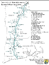
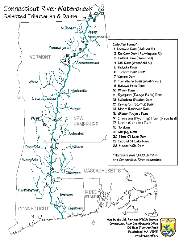
Connecticut River
The Connecticut RiverConnecticut River
The Connecticut River is the largest and longest river in New England, and also an American Heritage River. It flows roughly south, starting from the Fourth Connecticut Lake in New Hampshire. After flowing through the remaining Connecticut Lakes and Lake Francis, it defines the border between the...
drains south. Flowing into it are:
- Deerfield RiverDeerfield RiverDeerfield River is a river that runs for from southern Vermont through northwestern Massachusetts to the Connecticut River. The Deerfield was historically influential in the settlement of western Franklin County, Massachusetts, and its namesake town...
, Greenfield, MassachusettsGreenfield, MassachusettsGreenfield is a city in Franklin County, Massachusetts, United States. The population was 17,456 at the 2010 census. It is the county seat of Franklin County. Greenfield is home to Greenfield Community College, the Pioneer Valley Symphony Orchestra, and the Franklin County Fair...
- Green River, Greenfield, MassachusettsGreenfield, MassachusettsGreenfield is a city in Franklin County, Massachusetts, United States. The population was 17,456 at the 2010 census. It is the county seat of Franklin County. Greenfield is home to Greenfield Community College, the Pioneer Valley Symphony Orchestra, and the Franklin County Fair...
- Glastenbury River, SomersetSomerset, VermontSomerset is a town in Windham County, Vermont, United States. As of the 2000 census, the town had a total population of 5, and is one of only a handful of places in the United States with a population of five people. Somerset is one of five unincorporated towns in Vermont. The town disincorporated...
- Green River, Greenfield, Massachusetts
- Fall River, Greenfield, MassachusettsGreenfield, MassachusettsGreenfield is a city in Franklin County, Massachusetts, United States. The population was 17,456 at the 2010 census. It is the county seat of Franklin County. Greenfield is home to Greenfield Community College, the Pioneer Valley Symphony Orchestra, and the Franklin County Fair...
- Whetstone Brook, Brattleboro, VermontBrattleboro, VermontBrattleboro, originally Brattleborough, is a town in Windham County, Vermont, United States, located in the southeast corner of the state, along the state line with New Hampshire. The population was 12,046 at the 2010 census...
- West RiverWest River (Vermont)The West River is a tributary of the Connecticut River, about long, in southern Vermont in the United States. According to the Geographic Names Information System, it has also been known historically as "Wantastiquet" and as "Waters of the Lonely Way"...
, BrattleboroBrattleboro, VermontBrattleboro, originally Brattleborough, is a town in Windham County, Vermont, United States, located in the southeast corner of the state, along the state line with New Hampshire. The population was 12,046 at the 2010 census...
- Rock RiverRock River (West River)The Rock River is a tributary of the West River in southern Vermont in the United States. Via the West River, it is part of the watershed of the Connecticut River....
, NewfaneNewfane, VermontNewfane is the shire town of Windham County, Vermont, United States. The population was 1,680 at the 2000 census. The town includes the villages of Newfane and Williamsville.-History:... - Wardsboro Brook, JamaicaJamaica, VermontJamaica is a town in Windham County, Vermont, United States. The population was 946 at the 2000 census. Jamaica includes the villages of East Jamaica and Rawsonville....
- Winhall River, LondonderryLondonderry, VermontLondonderry is a town in Windham County, Vermont, United States. It is bounded on the north by Landgrove and Weston, on the east by Windham, on the south by Jamaica and on the west by Winhall and Landgrove. The population was 1,709 at the 2000 census. Londonderry also includes the village of South...
- Utley Brook, LondonderryLondonderry, VermontLondonderry is a town in Windham County, Vermont, United States. It is bounded on the north by Landgrove and Weston, on the east by Windham, on the south by Jamaica and on the west by Winhall and Landgrove. The population was 1,709 at the 2000 census. Londonderry also includes the village of South...
- Rock River
- Saxtons RiverSaxtons RiverThe Saxtons River is a river in the U.S. state of Vermont, a tributary of the Connecticut River. Its watershed covers and a range in altitude of ; land use is about 80% forested and 3% agricultural, and the upper river supports wild brook trout and brown trout, while Atlantic salmon occur but are...
, WestminsterWestminster (town), VermontWestminster is a town in Windham County, Vermont, United States. The population was 3,210 at the 2000 census.-Geography:According to the United States Census Bureau, the town has a total area of 46.1 square miles , of which 46.1 square miles is land and 0.04 square mile is... - Williams RiverWilliams River (Vermont)The Williams River is a river in the U.S. state of Vermont. It is a tributary of the Connecticut River. Its watershed covers 117 square miles; land use is about 80% forested and 4% agricultural, and the upper river supports wild brook trout and brown trout ....
, RockinghamRockingham, VermontRockingham is a town in Windham County, Vermont, United States, along the Connecticut River. The population was 5,309 at the 2000 census. Rockingham includes the incorporated villages of Bellows Falls and Saxtons River, as well as a large rural area west of Interstate 91.Rockingham has no formal...
- Middle Branch Williams River, ChesterChester, VermontChester is a town in Windsor County, Vermont, United States. The population was 3,044 at the 2000 census. The town was originally chartered by New Hampshire Governor Benning Wentworth as Flamstead in 1754. The terms of the charter were not met and the town was re-chartered as New Flamstead in 1761...
- Middle Branch Williams River, Chester
- Black RiverBlack River (Connecticut River)The Black River is a river in the U.S. state of Vermont, and a tributary of the Connecticut River. The watershed, or drainage basin, consists of some in southeastern Vermont, almost all of which lies in Windsor County.-Course:...
, SpringfieldSpringfield, VermontSpringfield is a town in Windsor County, Vermont, United States. The population was 9,373 at the 2010 census.-History:One of the New Hampshire grants, the township was chartered on August 20, 1761 by Governor Benning Wentworth and awarded to Gideon Lyman and 61 others... - Mill Brook, WindsorWindsor, VermontWindsor is a town in Windsor County, Vermont, United States. The population was 3,756 at the 2000 census.-History:One of the New Hampshire grants, Windsor was chartered as a town on July 6, 1761 by Colonial Governor Benning Wentworth. It was first settled in August 1764 by Captain Steele Smith and...
- Ottauquechee RiverOttauquechee RiverThe Ottauquechee River is a river in eastern Vermont in the United States. It is a tributary of the Connecticut River, which flows to Long Island Sound....
, HartlandHartland, VermontHartland is a town in Windsor County, Vermont, United States. The population was 3,223 at the 2000 census.-Geography:According to the United States Census Bureau, the town has a total area of 45.2 square miles , of which 45.0 square miles is land and 0.2 square mile is water...
- Barnard Brook, Woodstock
- Broad Brook, BridgewaterBridgewater, VermontBridgewater is a town in Windsor County, Vermont, United States. The population was 980 at the 2000 census. Bridgewater contains the hamlets of Bridgewater Village, Bridgewater Corners, West Bridgewater, and Bridgewater Center...
- North Branch Ottauquechee River, BridgewaterBridgewater, VermontBridgewater is a town in Windsor County, Vermont, United States. The population was 980 at the 2000 census. Bridgewater contains the hamlets of Bridgewater Village, Bridgewater Corners, West Bridgewater, and Bridgewater Center...
- White RiverWhite River (Vermont)The White River is a river in the U.S. state of Vermont. It is a tributary of the Connecticut River.The White River rises at Skylight Pond south of Bread Loaf Mountain near the crest of the Green Mountains. The river flows east to the town of Granville, where it receives the outflow from the...
, White River JunctionWhite River Junction, VermontWhite River Junction is an unincorporated village and census-designated place in the town of Hartford in Windsor County, Vermont, United States...
- First Branch White River, South Royalton
- Second Branch White River, North Royalton
- Third Branch White River, BethelBethel, VermontBethel is a town in Windsor County, Vermont, United States. The population was 1,968 at the 2000 census. The town includes the locations of Bethel-Gilead, East Bethel, Lilliesville, Lympus , and West Bethel...
- Tweed River, StockbridgeStockbridge, VermontStockbridge is a town in Windsor County, Vermont, United States. The population was 674 at the 2000 census.Stockbridge was one of thirteen Vermont towns isolated by flooding caused by Hurricane Irene in 2011.-Geography:...
- West Branch White River, RochesterRochester, VermontRochester is a town in Windsor County, Vermont, United States. The population was 1,171 at the 2000 census. Rochester is home to the Quarry Hill Creative Center...
- Ompompanoosuc RiverOmpompanoosuc RiverThe Ompompanoosuc River is a river, about 25 mi long, in eastern Vermont in the United States. It is a tributary of the Connecticut River, which flows to Long Island Sound...
, NorwichNorwich, VermontNorwich is a town in Windsor County, Vermont, United States, located along the Connecticut River opposite Hanover, New Hampshire. The population was 3,544 at the 2000 census....
- West Branch Ompompanoosuc River, ThetfordThetford, VermontThetford is a town in Orange County, Vermont, United States in the Connecticut River Valley. The population was 2,617 at the 2000 census. Villages within the town include East Thetford, North Thetford, Thetford Hill, Thetford Center, Rices Mills and Post Mills. The town office is in Thetford...
- West Branch Ompompanoosuc River, Thetford
- Waits RiverWaits RiverThe Waits River is a river in eastern Vermont in the United States. It is a tributary of the Connecticut River, which flows to Long Island Sound...
, BradfordBradford (village), VermontBradford is an unincorporated village in the town of Bradford, Orange County, Vermont, United States. The population was 815 at the 2000 census, at which time it was an incorporated village. The village disincorporated on December 1, 2004...
- South Branch Waits River, BradfordBradford, VermontBradford is a town in Orange County, Vermont, United States. The population was 2,619 at the 2000 census.-History:The first settler was John Hosmer in 1765...
- South Branch Waits River, Bradford
- Wells RiverWells River (Vermont)The Wells River is a river, approximately long, in the U.S. state of Vermont. It is a tributary of the Connecticut River.The Wells River begins at the outlet of Ricker Pond at the southern boundary of Groton State Forest in the town of Groton. The river flows generally southeast through the...
, Wells RiverWells River, VermontWells River is a village in the town of Newbury in Orange County, Vermont, United States. The population was 325 at the 2000 census. The village center is located at the junction of U.S... - Stevens River, BarnetBarnet, VermontBarnet is a town in Caledonia County, Vermont, United States. The population was 1,690 at the 2000 census. Barnet contains the locations of Barnet Center, East Barnet, McIndoe Falls, Mosquitoville, Passumpsic and West Barnet.-Geography:...
- Passumpsic RiverPassumpsic RiverThe Passumpsic River is a tributary of the Connecticut River, in Vermont. Though primarily a Caledonia County river, it is the only river to flow through all three counties of the Northeast Kingdom.- Course :...
, BarnetBarnet, VermontBarnet is a town in Caledonia County, Vermont, United States. The population was 1,690 at the 2000 census. Barnet contains the locations of Barnet Center, East Barnet, McIndoe Falls, Mosquitoville, Passumpsic and West Barnet.-Geography:...
- Joes Brook, BarnetBarnet, VermontBarnet is a town in Caledonia County, Vermont, United States. The population was 1,690 at the 2000 census. Barnet contains the locations of Barnet Center, East Barnet, McIndoe Falls, Mosquitoville, Passumpsic and West Barnet.-Geography:...
- Sleepers River, St. JohnsburySt. Johnsbury, VermontSt. Johnsbury is the shire town of Caledonia County, Vermont, United States. The population was 7,571 at the 2000 census. St. Johnsbury is located approximately northwest of the Connecticut River and south of the Canadian border.St...
- Moose River, St. JohnsburySt. Johnsbury, VermontSt. Johnsbury is the shire town of Caledonia County, Vermont, United States. The population was 7,571 at the 2000 census. St. Johnsbury is located approximately northwest of the Connecticut River and south of the Canadian border.St...
- Miller Run, LyndonvilleLyndonville, VermontLyndonville is a village in the town of Lyndon, in Caledonia County, Vermont, United States. Lyndonville's population was 1,227 at the 2000 census.-History:...
- Sutton River, West BurkeWest Burke, VermontWest Burke is a village in the town of Burke, Caledonia County, Vermont, United States. The population was 364 at the 2000 census.-Geography:...
- Joes Brook, Barnet
- Paul Stream, BrunswickBrunswick, VermontBrunswick is a town in Essex County, Vermont, United States. The town was named after Prince Karl Wilhelm Ferdinand of Brunswick-Lunenburg. The population was 107 at the 2000 census. It is part of the Berlin, NH–VT Micropolitan Statistical Area. Brunswick is home to six mineral springs that...
- Nulhegan River, BloomfieldBloomfield, VermontBloomfield is a town in Essex County, Vermont, United States. The population was 261 as of the 2000 census. It is part of the Berlin, NH–VT Micropolitan Statistical Area...
- Leach Creek, CanaanCanaan, VermontCanaan is a town in Essex County, Vermont, United States. The population was 1,078 at the 2000 census. Canaan contains the village of Beecher Falls, located at the confluence of the Connecticut River and Halls Stream...
- Halls StreamHalls StreamHalls Stream is a 25.2 mile long tributary of the Connecticut River. For most of its length, it forms the boundary between Canada and the United States, with the province of Quebec to its west and the state of New Hampshire to its east....
, Beecher FallsCanaan, VermontCanaan is a town in Essex County, Vermont, United States. The population was 1,078 at the 2000 census. Canaan contains the village of Beecher Falls, located at the confluence of the Connecticut River and Halls Stream...
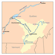
Lake Memphremagog
Lake MemphremagogLake Memphremagog
Lake Memphremagog is a fresh water glacial lake located between Newport, Vermont, United States and Magog, Quebec, Canada. The lake is long with 73 percent of the lake's surface area in Quebec, where it drains into the Magog River. However, three-quarters of its watershed, , is in Vermont. The...
drains north via the Magog River
Magog River
The Magog River is a river that drains Lake Memphremagog. The cities of Sherbrooke and Magog, Quebec, lie on the river. Engineers from the University of Sherbrooke have constructed a plastic bridge on the river. - Dams :...
in Quebec to the Saint-François River
Saint-François River
The Saint-François River is a river in the Canadian province of Quebec.The Saint-François takes its source from Lake Saint-François in Chaudière-Appalaches, southeast of Thetford Mines...
at Sherbrooke. Flowing into the lake are:
- Johns River, DerbyDerby, VermontDerby is a town in Orleans County, Vermont, United States. The population was 4,604 at the 2000 census. The town contains four unincorporated villages: Beebe Plain, Clyde Pond, Lake Salem and North Derby; and two incorporated villages: Derby Center and Derby Line...
- Clyde RiverClyde River (Vermont)The Clyde River is a tributary of Lake Memphremagog, over long, in northern Vermont in the United States. It is the easternmost of the four major rivers in Orleans County. It is the most powerful of the four within Orleans County, powering several turbines at damsites...
, NewportNewport (city), VermontNewport is a city in and the shire town of Orleans County, Vermont, United States. As of the 2000 census, the city population was 5,005. The city contains the largest population of any government in the county, yet encompasses the smallest area....
- Pherrins River, Island PondIsland Pond, VermontIsland Pond is a census-designated place in the town of Brighton in Essex County, Vermont, United States. The population was 849 at the 2000 census...
- Pherrins River, Island Pond
- Black River, Newport
- Fairfield River, FairfieldFairfield, VermontFairfield is a town in Franklin County, Vermont, United States. The population was 1,800 at the 2000 census. It is believed President Chester A...
- Fairfield River, Fairfield
- Barton RiverBarton RiverThe Barton River is a tributary of Lake Memphremagog, over long, in northern Vermont in the United States.It runs north from Glover through Barton, Brownington, Coventry and drains through Newport into Lake Memphremagog's South Bay.-Course:...
, Newport- Willoughby River, OrleansOrleans, VermontOrleans is a village in the northwestern corner of Barton, Orleans County, Vermont, United States. The population was 826 at the 2000 census, making it the largest village in Orleans County.-Government:...
- Brownington Branch, BrowningtonBrownington, VermontBrownington is a town in Orleans County, Vermont, United States. The population was 885 as of the 2000 census.-Geography:According to the United States Census Bureau, the town has a total area of 28.4 square miles , of which 28.3 square miles is land and 0.1 square mile is...
- Brownington Branch, Brownington
- Willoughby River, Orleans
Massawippi River
- Coaticook River, Sherbrooke, Quebec
- The Tomifobia RiverTomifobia RiverThe Tomifobia River is a flowing body of fresh water in the Eastern Townships region of Quebec. The river forms a part of an international border between Canada and the United States near the village of Beebe Plain, Vermont.-Course:...
, which straddles the Vermont-Quebec border for a few kilometers near the village of Stanstead, QuebecStanstead, QuebecStanstead is a town of about 3,000 people, part of the Memphrémagog Regional County Municipality in the Estrie region of Québec. Stanstead is located on the Canada-United States border across from Derby Line, Vermont....
and eventually drains north.
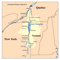
Lake Champlain
Lake ChamplainLake Champlain
Lake Champlain is a natural, freshwater lake in North America, located mainly within the borders of the United States but partially situated across the Canada—United States border in the Canadian province of Quebec.The New York portion of the Champlain Valley includes the eastern portions of...
drains into the Richelieu River
Richelieu River
The Richelieu River is a river in Quebec, Canada. It flows from the north end of Lake Champlain about north, ending at the confluence with the St. Lawrence River at Sorel-Tracy, Quebec downstream and northeast of Montreal...
in Québec
Quebec
Quebec or is a province in east-central Canada. It is the only Canadian province with a predominantly French-speaking population and the only one whose sole official language is French at the provincial level....
, thence into the Saint Lawrence River, and into the Gulf of Saint Lawrence.
- Pike River, Venise-en-Quebec, QuébecQuebecQuebec or is a province in east-central Canada. It is the only Canadian province with a predominantly French-speaking population and the only one whose sole official language is French at the provincial level....
- Rock RiverRock River (Lake Champlain)The Rock River is a short tributary of Lake Champlain in northern Vermont in the United States and southern Quebec in Canada. Via Lake Champlain and the Richelieu River, it is part of the watershed of the St. Lawrence River...
, HighgateHighgate, VermontHighgate is a town in Franklin County, Vermont, United States. The population was 3,397 at the 2000 census. The town is on the border of Quebec, Canada and is a border town of Philipsburg, Quebec.-History:... - Missisquoi RiverMissisquoi RiverThe Missisquoi River is a tributary of Lake Champlain, approximately 80 mi long, in northern Vermont in the United States and southern Quebec in Canada. It drains a rural area of the northern Green Mountains along the US-Canada border northeast of Lake Champlain, and an area of Quebec's Eastern...
, SwantonSwanton (town), VermontSwanton is a town in Franklin County, Vermont, United States. The population was 6,203 at the 2000 census.-Geography:According to the United States Census Bureau, the town has a total area of 61.7 square miles , of which 48.4 square miles is land and 13.3 square miles is...
- Black Creek, SheldonSheldon, VermontSheldon is a town in Franklin County, Vermont, United States. The population was 1,990 at the 2000 census. It contains the unincorporated village of Sheldon Springs.-Geography:...
- Tyler Branch, SheldonSheldon, VermontSheldon is a town in Franklin County, Vermont, United States. The population was 1,990 at the 2000 census. It contains the unincorporated village of Sheldon Springs.-Geography:...
- Trout River, BerkshireBerkshire, VermontBerkshire is a town in Franklin County, Vermont, United States. The population was 1,388 at the 2000 census. It contains the unincorporated village of East Berkshire.-Geography:...
- Black Creek, Sheldon
- Mill River, GeorgiaGeorgia, VermontGeorgia is a town in Franklin County, Vermont, United States. The population was 4,375 at the 2000 census.-Geography:According to the United States Census Bureau, the town has a total area of 45.2 square miles , of which, 39.5 square miles of it is land and 5.7 square miles of it ...
- Lamoille RiverLamoille RiverThe Lamoille River is a river which runs through northern Vermont and drains into Lake Champlain. It is about in length, and has a drainage area of around . The river generally flows southwest, and then northwest, from the water divide of the Green Mountains, and is the namesake of Lamoille...
, MiltonMilton, VermontMilton is a town in Chittenden County, Vermont, United States. The population was 10,352 at the 2010 census. According to local legend, the town was named for the English poet John Milton, but the name most likely originated from William FitzWilliam, 4th Earl FitzWilliam, who held the title...
- Browns RiverBrowns River (Vermont)For other places named "Browns River," see Browns River .The Browns River is an approximately waterway in northern Vermont...
, FairfaxFairfax, VermontFairfax is a town in Franklin County, Vermont, United States. The population was 3,765 at the 2000 census.-Geography:According to the United States Census Bureau, the town has a total area of 40.5 square miles , of which, 40.2 square miles of it is land and 0.3 square miles of it ...
- Lee River, Jericho
- Seymour River, CambridgeCambridge, VermontCambridge is a town in Lamoille County, Vermont, United States. The population was 3,186 at the 2000 U.S. Census. Cambridge includes the village of Jeffersonville.-History:...
- Brewster River, JeffersonvilleJeffersonville, VermontJeffersonville is a village in the town of Cambridge, Vermont, United States. The population was 568 at the 2000 census.-History:The village was originally called Cambridge Center, the name was changed to Jeffersonville in 1827 to honor Thomas Jefferson...
- North Branch Lamoille River, CambridgeCambridge, VermontCambridge is a town in Lamoille County, Vermont, United States. The population was 3,186 at the 2000 U.S. Census. Cambridge includes the village of Jeffersonville.-History:...
- Gihon River, Johnson
- Green River, WolcottWolcott, VermontWolcott is a town in Lamoille County, Vermont, United States. The town was named for General Oliver Wolcott, a signer of the Declaration of Independence...
- Browns River
- Winooski RiverWinooski RiverThe Winooski River is a tributary of Lake Champlain, approximately long, in northern Vermont in the United States. Although not Vermont's longest river, it is one of the state's most significant, forming a major valley way from Lake Champlain through the Green Mountains towards the Connecticut...
, ColchesterColchester, VermontColchester is a town in Chittenden County, Vermont, United States. The population was 17,067 at the 2010 census. It is the fourth-largest municipality and second-largest town in Vermont by population.-Geography:...
/BurlingtonBurlington, VermontBurlington is the largest city in the U.S. state of Vermont and the shire town of Chittenden County. Burlington lies south of the U.S.-Canadian border and some south of Montreal....
- Huntington River, RichmondRichmond, VermontRichmond is a town in Chittenden County, Vermont, United States. The 2000 census revealed a population of 4,090.Local students attend Mount Mansfield Union High School, Camel's Hump Middle School, And Richmond Elementary School. Mount Mansfield Union High is in the neighboring town of Jericho...
- Little River, WaterburyWaterbury, VermontWaterbury is a town in Washington County in central Vermont, in the United States. It is also the name of a village within that town. The population was 4,915 at the 2000 census.-Economy:-Industry:...
- Mad RiverMad River (Vermont)The Mad River is a tributary to the Winooski River in Vermont. It has its headwaters in Granville Gulf, then flows north through the towns of Warren, Waitsfield, and Moretown before entering the Winooski River just downstream from Middlesex. Other towns within the Mad River watershed are the...
, MiddlesexMiddlesex, VermontMiddlesex is a town in Washington County, Vermont, United States. The population was 1,729 at the 2000 census.-Geography:According to the United States Census Bureau, the town has a total area of 39.9 square miles , of which, 39.7 square miles of it is land and 0.2 square miles of... - Dog River, MontpelierMontpelier, VermontMontpelier is a city in the U.S. state of Vermont that serves as the state capital and the shire town of Washington County. As the capital of Vermont, Montpelier is the site of the Vermont State House, seat of the legislative branch of Vermont government. The population was 7,855 at the 2010...
- North Branch Winooski River, MontpelierMontpelier, VermontMontpelier is a city in the U.S. state of Vermont that serves as the state capital and the shire town of Washington County. As the capital of Vermont, Montpelier is the site of the Vermont State House, seat of the legislative branch of Vermont government. The population was 7,855 at the 2010...
- Stevens Branch, MontpelierMontpelier, VermontMontpelier is a city in the U.S. state of Vermont that serves as the state capital and the shire town of Washington County. As the capital of Vermont, Montpelier is the site of the Vermont State House, seat of the legislative branch of Vermont government. The population was 7,855 at the 2010...
- Kingsbury Branch, East MontpelierEast Montpelier, VermontEast Montpelier is a town in Washington County, Vermont, United States. The population was 2,578 at the 2000 census.-Geography:According to the United States Census Bureau, the town has a total area of 32.1 square miles , of which 32.0 square miles is land and 0.1 square mile is...
- Jail Branch RiverJail Branch RiverThe Jail Branch River is a river in central Vermont. It is a tributary of the Stevens Branch of the Winooski River and part of the Lake Champlain watershed....
, Barre
- Jail Branch River
- Huntington River, Richmond
- La Platte River, ShelburneShelburne, VermontShelburne is a town in southwestern Chittenden County, Vermont, United States, along the shores of Lake Champlain. The population was 7,144 at the 2010 census.-History:...
- Lewis Creek, Ferrisburg
- Little Otter Creek, Ferrisburg
- Otter Creek, Ferrisburg
- Lemon Fair River, WeybridgeWeybridge, VermontWeybridge is a town in Addison County, Vermont, United States. The population was 824 at the 2000 census.-Geography:According to the United States Census Bureau, the town has a total area of 17.6 square miles , of which 17.0 square miles is land and 0.6 square mile is...
- Little Lemon Fair River, OrwellOrwell, VermontOrwell is a town in Addison County, Vermont, United States. The population was 1,185 at the 2000 census. Mount Independence was the largest fortification constructed by the American colonial forces...
- Little Lemon Fair River, Orwell
- New Haven River, WeybridgeWeybridge, VermontWeybridge is a town in Addison County, Vermont, United States. The population was 824 at the 2000 census.-Geography:According to the United States Census Bureau, the town has a total area of 17.6 square miles , of which 17.0 square miles is land and 0.6 square mile is...
- Middlebury River, Middlebury
- Leicester River, LeicesterLeicester, VermontLeicester is a town in Addison County, Vermont, United States. The population was 974 at the 2000 census.Satans Kingdom is an unincorporated community located in Leicester.-Geography:...
- Neshobe River, Brandon
- Clarendon River, RutlandRutland (town), VermontRutland is a town in Rutland County, Vermont, United States. The population was 4,054 at the 2010 census. Rutland completely surrounds the city of Rutland, which is incorporated separately from the town of Rutland.-History:...
- East Creek, Rutland
- Cold River, ClarendonClarendon, VermontClarendon is a town in Rutland County, Vermont, United States. The population was 2,571 at the 2010 census. Clarendon spans U.S. Route 7 and is split by the highway, the Cold River and Mill River, Otter Creek, and the Green Mountains into the villages of Clarendon, West Clarendon, East Clarendon,...
- Mill River, ClarendonClarendon, VermontClarendon is a town in Rutland County, Vermont, United States. The population was 2,571 at the 2010 census. Clarendon spans U.S. Route 7 and is split by the highway, the Cold River and Mill River, Otter Creek, and the Green Mountains into the villages of Clarendon, West Clarendon, East Clarendon,...
- Lemon Fair River, Weybridge
- Mettawee RiverMettawee RiverMettawee River is a river in western Vermont and eastern New York in the United States, passing the town of Granville, New York. The river is particularly good for rapids and kayaking. It ends in Lake Champlain....
, West Haven, VermontWest Haven, VermontWest Haven is a town in Rutland County, Vermont, United States. The population was 264 at the 2010 census.-Geography:According to the United States Census Bureau, the town has a total area of , of which is land and , or 1.72%, is water.-Demographics:...
/Whitehall, New YorkWhitehall (town), New YorkWhitehall is a town in Washington County, New York, United States. It is part of the Glens Falls Metropolitan Statistical Area. The town population was 4,035 at the 2000 census.The Town of Whitehall contains a village also named Whitehall.- History :...
- Indian River, GranvilleGranville, VermontGranville is a town in Addison County, Vermont, United States. The population was 303 at the 2000 census. The town was originally called Kingston but was renamed in 1834....
- Indian River, Granville
- Poultney RiverPoultney RiverThe Poultney River goes through Vermont and New York, and ends in Lake Champlain....
, West Haven, VermontWest Haven, VermontWest Haven is a town in Rutland County, Vermont, United States. The population was 264 at the 2010 census.-Geography:According to the United States Census Bureau, the town has a total area of , of which is land and , or 1.72%, is water.-Demographics:...
/Whitehall, New YorkWhitehall (town), New YorkWhitehall is a town in Washington County, New York, United States. It is part of the Glens Falls Metropolitan Statistical Area. The town population was 4,035 at the 2000 census.The Town of Whitehall contains a village also named Whitehall.- History :...
- Hubbardton River, West HavenWest Haven, VermontWest Haven is a town in Rutland County, Vermont, United States. The population was 264 at the 2010 census.-Geography:According to the United States Census Bureau, the town has a total area of , of which is land and , or 1.72%, is water.-Demographics:...
- Castleton River, Fair Haven
- Hubbardton River, West Haven
Hudson River
The Hudson RiverHudson River
The Hudson is a river that flows from north to south through eastern New York. The highest official source is at Lake Tear of the Clouds, on the slopes of Mount Marcy in the Adirondack Mountains. The river itself officially begins in Henderson Lake in Newcomb, New York...
in New York
New York
New York is a state in the Northeastern region of the United States. It is the nation's third most populous state. New York is bordered by New Jersey and Pennsylvania to the south, and by Connecticut, Massachusetts and Vermont to the east...
drains into New York Bay
New York Bay
New York Bay is the collective term for the marine areas surrounding the entrance of the Hudson River into the Atlantic Ocean. Its two largest components are Upper New York Bay and Lower New York Bay, which are connected by The Narrows...
.
- Hoosic RiverHoosic RiverThe Hoosic River, also known as the Hoosac, the Hoosick and the Hoosuck , is a tributary of the Hudson River in the northeastern United States. The different spellings are the result of varying transliterations of the river's original Algonquian name...
, Schaghticoke, New YorkSchaghticoke (town), New YorkSchaghticoke is a town in Rensselaer County, New York, USA. The population was 7,456 at the 2000 census. The Schaghticoke is a native tribe original to the area. The town is on the northern border of the county, north of Troy...
- Walloomsac RiverWalloomsac RiverThe Walloomsac River from the Native American name, Wal-loom-sac is a tributary of the Hoosic River in the northeastern United States. It rises in southwestern Vermont, in the Green Mountains east of the town of Bennington in Woodford Hollow at the confluence of Bolles Brook and City Stream where...
, Hoosick, New YorkHoosick, New YorkHoosick is a town in Rensselaer County, New York, United States. The population was 6,759 at the 2000 census.The Town of Hoosick is in the northeast corner of the county.- History :...
- Roaring Branch, Bennington
- Walloomsac River
- Batten KillBatten KillThe Batten Kill, or Battenkill, or the Battenkill River, is a river rising in Vermont that flows into New York and is a tributary of the Hudson River....
, Greenwich, New YorkGreenwich (town), New YorkGreenwich is a town in the southwest part of Washington County, New York, United States. The town is located on the west border of the county. The population was 4,896 at the 2000 census. It is part of the Glens Falls Metropolitan Statistical Area...
- Green River, West Arlington
- Roaring Branch, Arlington