
History of the Ecuadorian-Peruvian territorial dispute
Encyclopedia
The territorial dispute
between Ecuador
and Peru
was the source of the longest-running international armed conflict in the Western Hemisphere. This dispute was a consequence of the imprecise geographical definitions used in colonial times to define the limits of the Royal Audiences; after Peru and neighboring Gran Colombia
proclaimed independence from the Spanish crown in 1821 and 1819, respectively, this dispute led to the war of 1828. In the aftermath, the belligerent parties agree to proclaim their limits in the basis of the principle "Utis Posedetis" and the border became the one that existed between the Spanish viceroyalties of Peru
and New Granada
.
When the Republic of Ecuador proclaimed its secession
from Gran Colombia in 1830 its government negotiated a swap of territories in the Amazon basin for debt with the British creditors, and the dispute over the territories re-ignited in 1857. Peru implemented a maritime blockade
of the port of Guayaquil
demanding a revocation of the deal, as well as an acknowledgment of Peruvian sovereignty over the disputed territories. These demands went unheeded and with Ecuador in a state of civil war, the government of Guillermo Franco
in the province of Guayaquil, claiming to represent the entire country, agreed to Peru's demands and signed the Treaty of Mapasingue
of 1860. Gabriel García Moreno
's provisional government won the civil war later that year, and voided this treaty, with the new Peruvian government following suit several years later.
The dispute continued through the late 19th century and beginning of the 20th century. Numerous attempts were made to define the borders, but both governments could not deal to an agreement acceptable to their constituencies. A war between Colombia and Peru occurred during 1932 and 1933 in the Eastern region of the Amazon territories and resulted in the official designation of the Putumayo River
as a border between Colombia and Peru; but sectors of the society considered this detrimental to the Ecuadorian cause, with Colombia now recognizing Peru's rights to the territory that Ecuador claimed as its own. An agreement recognizing territories in de facto
possession by each country was signed in 1936, but minor military skirmishes began to occur in 1938. Tensions escalated, and war broke out in July 1941, and officially came to an end with the signing of the Rio de Janeiro Protocol
on January 29, 1942. The treaty was intended to finally bring the long-running territorial dispute to an end, but in 1960 the then president of Ecuador Dr. José Mª Velasco Ibarra proposed to the Congress a thesis of nullity based in the fact that the 1942 protocol was forced unto the Ecuadorian government under duress.
A brief military clash took place in early 1981, when the Peruvian Army
forcefully took control of three Ecuadorian military outposts on the eastern slopes of the Cordillera del Cóndor
mountain range. An agreement in 1992 between the presidents of the two countries promised to seek peaceful resolution to the conflict. However, in December 1994, the Ecuadorian army was seen to be mobilizing in the vicinity of the Cordillera del Cóndor. On January 26, 1995, war broke out
over control of several outposts located on the headwaters of the Cenepa River
, within a 78-kilometer strip of territory that both countries claimed as their own. In contrast to previous encounters, which had resulted in favorable outcomes for Peru, Ecuador was able to claim limited but emotionally significant tactical success, retaining control of the embattled outpost of Tiwinza and wresting local air superiority from the Peruvian Air Force
. The fighting came to an end after just over one month, with the signing of the Montevideo Declaration on February 28, and the later signing of the Itamaraty Peace Declaration under the supervision of the guarantors of the Rio Protocol of 1942: Argentina
, Brazil
, Chile
, and the U.S.
Tensions subsided but persisted over the next three years. On October 26, 1998, Ecuador and Peru signed a comprehensive peace accord that established a framework for ending a border dispute. Formal demarcation of border regions started on May 13, 1999. The agreement was ratified without opposition by the congresses of both nations, finally bringing an end to the dispute, almost two centuries after the South American nations (or their predecessors) claimed their independence from the Spanish Crown.
in 1492, the Spanish conquistadores expanded the range of the Spanish Crown's
reach from early small settlements in the Caribbean to various continental territories, eventually including Central America
and most of South America
.
The Spaniards arrived at the borders of the Inca Empire
in 1528, and on November 16, 1532, taking advantage of the Inca Civil War
, the tiny army of Francisco Pizzaro began the Spanish conquest of Peru. In the following decades, Spain consolidated its power over the entire Andean region, repressing successive indigenous rebellions.
To govern the new territories of Spain, in 1542 Holy Roman Emperor
Charles V
(King Charles I of Spain) created two Viceroyalties, the Viceroyalty of New Spain (in modern-day Mexico
) and the Viceroyalty of Peru
(a.k.a. the Viceroyalty of New Castile). In 1542, King Charles named Blasco Núñez Vela
Peru's first viceroy, but the viceroyalty was not organized until the arrival of Viceroy Francisco de Toledo
in 1572. Toledo promptly declared war on Vilcabamba
, the last refuge of the Inca; soon afterwards, Tupac Amaru
, the last Inca emperor, was captured and executed in Cuzco.
 Because the territory of the Viceroyalty of Peru was so large, and far away from centers of government in Lima
and Santo Domingo
, Peru (as well as New Spain) was divided into a number of real audiencias (royal audiences), a type of superior judicial tribunal that combined executive and judicial authority, and can be considered "major province
s". The audiences controlled the gobernaciones,Defined as "the civil, as distinguished from the military, branch of the colonial governmental entities lesser in extent than the audiencias." (1910) alcaldias mayores,Defined as "the jurisdiction of the Alcalde mayor, who, as mayor, governed a town of lesser importance than the capital of a province." (1910) corregimientos,Defined as "the district governed by a Corregidor, a correctional magistrate, who, in colonial times, exercised administrative functions over a district. (1910) and alcaldias ordinarias.Defined as "jurisdiction of the Alcalde ordinario, who was similar to the alcaldia mayor, but of lesser extent. (1910) The territory was also divided ecclesiastically, into archbishoprics, religious provinces, suggragan bishopries, parishes and curateships. The archbishoprics and religious provinces corresponded with the audiences, the bishoprics with the gobernaciones and alcaldias mayores, and the parishes and curateships with the corregimientos and alcaldias ordinarias.
These civil divisions were not uniform, with numerous exceptions being made based on the specific circumstances. The Viceroys were presidents of the audiences at the capitals of their Viceroyalties, with other audiences being presided over by captains-generals, or by persons known as gowned presidents. Power was devolved to the captains-general of an audience by the Viceroy, and the audience's territory was administered by the audience's president and the political, military, and religious officials underneath him.
Between 1542 and 1717, the Viceroyalty controlled most of the territory of South America (save for a few non-Spanish colonies and the Commandancy General of Caracas
, which was a dependency of the Captaincy General of Santo Domingo). The territory was divided among (noting dates of creation):
The district of an audience was established in the royal decree by which it was created; the laws laid out in the myriad of Cédulas Reales issued by the Spanish Crown were compiled several times throughout the centuries-long history of Spanish presence in the region. These compilations were referred to as the Laws of the Indies
; the 1680 compilation, organized under Charles II, known as the Recopilación de las Leyes de los Reynos de Indias (Compilation of the Laws of the Kingdoms of the Indies), set a template by which the laws were organized.
Under Title XV of Book II of the Recopilación, the limits of the audiences of Lima and Quito were defined as follows:
issued the Real Cédula of May 27, 1717. The order split off the northwestern corner of Peru and created the Viceroyalty of New Granada
. New Granada shared its capital with the Royal Audience of Santa Fé de Bogotá, and additionally had jurisdiction over the New Kingdom of Granada
, as well as the audiences of Tierra Firme (now called Panama), Quito, and the Captaincy General of Venezuela
. The territories of the Viceroyalty comprised the territories of, respectively, the modern Republics of Colombia, Ecuador
, Panama
, and Venezuela
, as well as the northern regions of Peru
, the Brazil
ian northwest, and the western part of Guyana
.
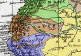
The Royal Audience of Quito had been established by a royal decree in 1563, its territory including Pasto
, Popayán
, Cali
, Buenaventura
and Buga
in what is currently Colombia
, and extended as far south as Piura
in what is now Peru
. The eastern limit was ill-defined at the time, due to a lack of geographical knowledge and the low importance given to unpopulated, hard-to-reach territories.
Having temporarily suppressed the Viceroyalty of New Granada, on November 5, 1723, Philip V emitted another Cédula, which returned control of the Royal Audience of Quito to the Viceroyalty of Peru. The Cédula of August 20, 1739 (also called the Cédula de Reerección Definitiva del Virreinato de Nueva Granada, "Definitive Decree of Re-erection of the Viceroyalty of New Granada") reinstated the viceroyalty with its 1717 territories, including the Royal Audience of Quito. The border between Quito and the Viceroyalty of Peru was defined in 1740 by another Cédula:
This cedula greatly modified the original demarcation, but served only to fix the starting point of the line on the pacific coast at the river Tumbes. This document was the first mention of the Tumbes as the boundary between the two viceroyalties.
issued the Real Cédula of 1802. The decree split the Government and Commandancy General of Maynas
and the Government of Quijos
from the Audience of Quito, and added them to the Viceroyalty of Peru. The text of the decree, as reproduced in the Annals of the diplomatic and consular missions of Colombia (1901), reads:
In a footnote, Dr. Antonio José Uribe, Minister of Foreign Affairs of Colombia
from 1901 to 1902, wrote,
thereby casting suspicion on the authenticity of one or more of the copies of the document, complicating the already difficult matter of interpreting its meaning.Bowman, p.759: "A royal cedula, dated 1802, complicated matters ... [there] was considerable uncertainty as to the validity of the cedula as well as its meaning..." (This paper was published in 1942, and establishes uncertainty of the Cedula's authenticity at least up until that date.)
According to Pedro Moncayo y Esparza, a 19th-century Ecuadorian writer, the Viceroy of Santa Fe and the President of Quito objected to the execution of the Real Cédula of 1802, as it had all the makings of an apocryphal document: it was not registered in the official cedulario, and its contents could not be found in the Recopilacion de Indias, nor had it been located in the Archive of the Indies in Spain
. However, during the Peruvian congressional committee hearings regarding the dismissal of the Treaty of Mapasingue, signed between Ecuador and Peru at the end of the dispute of 1857-1860, it was stated that the Real Cédula of 1802 and the documents proving its execution were found in the archives of the ancient government of Maynas.
The lack of clarity within the document as to whether the transfer of administrative power was purely military and ecclesiasticcal in nature, or territorial as well, formed the basis for an imprecise territorial situation between Ecuador and Peru when the two nations obtained their independence from Spain.
as President. On August 7 of that year, the independence of what is now Colombia
was won in the Battle of Boyacá
. The independence of Venezuela
was won on June 24, 1821 in the Battle of Carabobo
. One of Bolivar's generals, Venezuelan-born General Antonio José de Sucre
won the Battle of Pichincha
on May 24, 1822 and freed the territory that was then Ecuador.
Gran Colombia comprised what is now Colombia
, Ecuador
, Venezuela
and
Panama
. It was Simón Bolivar's dream to unite all of South America, a project which he would never achieve.
Even before the battles for the freedom of the South American colonies were over, Bolivar established the uti possidetis juris
principle as the basis for the territorial demarcation of the new nation-states that were to be born out of the ancient colonial jurisdictions. In essence, the principle stated that the borders of the new countries should correspond to the Spanish administrative borders, as they were in 1809. This would present some difficulties due to lack of geographical knowledge, and also because much of the territory was unpopulated and unexplored. By this principle, the territory of the Viceroyalty of Peru would become part of Peru, and the territory of the Viceroyalty of New Granada part of Gran Colombia.
, a republic that would unite most of the former Spanish colonies under his rule. Peruvian President José de la Mar
, who had been a member of Bolivar's troops during the wars of independence and born in Cuenca, Ecuador, had his own political ambition: to establish himself as the formal ruler of Peru. As a result, relations between Bolivar and de la Mar quickly cooled, and the two soon became rivals. Bolivar's promotion of Antonio José de Sucre to "Mariscal" (Marshall), which made him his personal war assistant, particularly angered de la Mar, who officially became Bolivar's enemy.
Deciding to free Peru (what is now Peru and Bolivia) from what he considered to be an authoritarian project, he promoted an anti-Bolivarian campaign which gained popular support and led to insurrections, both in Peru and in Bolivia (Alto Perú), where the Colombian Army was expelled. Finally, he decided to confront Bolivar more directly by launching an attack. On June 3, 1828, de la Mar invaded the southern region of Gran Columbia; he occupied Loja
and tried to capture Guayas
, and intended to annex those territories to Peru.
Furious when he received the news, Simon Bolivar resolved to declare war against Peru. Sucre was appointed Commander of the Colombian Army. In 1829, La Mar and General Agustin Gamarra
occupied Cuenca, but were defeated in what is known as the Battle of Portete de Tarqui (also known as the Battle of Tarqui
) by Sucre on February 27, 1829. A coup supported by General Gamarra in the Peruvian Army against President de la Mar paved the way for a peace treaty. Subsequently, the Convenio de Girón between Peru and Gran Colombia recognizes as borders the "same ones of the corresponding Viceroyalties before independence." On July 10, the Piura Armistice recognised the annexation of Guayaquil
to Gran Colombia, and on September 22, the war between Peru and Gran Colombia ended. http://www.webcitation.org/query?url=http://www.geocities.com/equatorial2000/&date=2009-10-25+21:52:12
The Gran Colombia federation dissolved during 1830 because of political struggles between regions which strengthened after Bolivar's resignation. Ecuador was born as a country on May 13, 1830 and began its separate existence with the adoption of a Constitution on September 23, 1830. According to this constitution, the Republic of Ecuador was composed of the provinces of Azuay
, Guayas
and Quito
. These provinces later divided into the many provinces that exist today in Ecuador.
In Peru, the dissolution of Gran Colombia is seen as a country ceasing to exist, giving way to the formation of new nation states that had nothing to do with the original federation. The significant implication of this view is that the treaties Peru had signed with Gran Colombia were voided, as the country in question no longer existed, and was replaced with three new states, the Republic of the New Granada (which subsequently changed its name to Republic of Colombia), the Republic of Venezuela and the Republic of Ecuador.
An alternative view is that Ecuador and Venezuela separated from the Gran Colombia Federation (from Colombia in actuality) and inherited any treaties that Gran Colombia had signed with Peru as they applied to their corresponding territories. There are indications that Colombia itself maintained this position. On the surface, it seems far-fetched that the Republic of Colombia after 1830 is a different country from the Republic of Colombia before 1830, even though they shared a capital city, a subset of territory and much of their citizenry. Additionally, the argument that border treaties are voided when federations are dissolved does not appear to have substantial merit and is clearly conflict-prone.
on August 11, 1830 by Peru and Gran Colombia as a result of the Battle of Portete de Tarqui. The protocol settled the eastern section of the disputed border from the Andes Mountains to Brazil by making the Marañón river
and Amazon river
the new border between the two republics. The protocol settled the western section of the border from the Andes Mountains to the Atlantic Ocean by making the Macará river and the Tumbes
river the new boundary. However, it left the status of a small area in the Andes Mountains named Jaén de Bracamoros in dispute. It was decided by Pedemonte and Mosquera that on a later date, either the Chinchipe River or the Huancabamba River would be chosen as the new boundary.
Ecuador has used this protocol as primary legal support of its core claims throughout the history of the conflict. Peru has disputed the credibility and the existence of the Pedemonte-Mosquera protocol on several points:
Even though it seems unlikely that Ecuador would have concocted a historical treaty of this nature, the fact that the existence of the original document cannot be demonstrated conclusively is significant.
Ecuador has managed to produce a copy made in 1870 that the Colombian embassy in Lima sent to Bogotá
. The copy in question was obtained from someone's personal collection. However, it was not certified by Peru and remains disputed.
The Mosquera-Pedemonte protocol is mentioned in a Colombian document titled Legislative Act No. 3 published October 31, 1910. http://www.cervantesvirtual.com/servlet/SirveObras/12726101947818273098435/p0000001.htm The document explains how the borders between Colombia and its neighbors have been established; as to its border with Peru, it indicates they are those adopted by Mosquera-Pedemonte, in development of the treaty of September 22, 1829.
There are conflicting versions of what exactly took place. For an Ecuadorian view point, see http://www.diccionariobiograficoecuador.com/tomos/tomo9/p3.htm.
For Peruvian points of view, see http://www.up.edu.pe/ciup/data%5C98-16.pdfhttp://www.congreso.gob.pe/libro1/3volum/11tudela.htm.
March 10, 1853: Creation of the Peruvian Government of Loreto
by president Castilla. (Ecuador at the time was undergoing a civil struggle.) On February 25, 1860, Peruvian minister Manuel Morales and his Ecuadorian counterpart, Nicolás Estrada, signed the Treaty of Mapasingue in order to end the dispute. (Mapasingue is a location near Guayaquil where Peruvian troops had stationed.) Ecuador voided the concession of territories claimed by Peru to the British, and Peru withdrew its forces. However, the territorial situation remained unclear and was left to be resolved at a later time.
Given these circumstances, the President of Peru, Manuel Prado Ugarteche
, ordered the formation of the North Grouping, a military unit in charge of the Northern Operational Theater, on January 11, 1941, consisting of two light divisions with three battalions each, plus four other independent battalions and three artillery batteries (one with six 105 mm guns) (Delgado).
In front of these forces, the Ecuadorian Border Security command had under its orders two Army battalions, the "Montecristi" and the "Cayambe", each one consisting of around 250 troops, armed with 7,92 mm Mauser
rifles and a couple of Czech 7,92 mm ZB-26 light machine-guns, plus two Vickers-Maxim machine-guns. There was also a "Córdova" battalion, made up of around 100 troops, and a so-called "Mariscal Sucre" artillery battery, with 71 troops and no artillery pieces. In fact, the only artillery in the whole province of El Oro consisted of six Italian 65 mm mountain guns, sold to Ecuador as leftovers from the Great War, and almost without shells. These guns were never put into action. (Rodríguez, 1943).
As for anti-aircraft defenses, the Ecuadorians had only a pair of 20 mm Breda
guns deployed on Puerto Bolivar, which was the only port of entry for supplies, reinforcements, and weapons to arrive to the province, by sea, from the port-city of Guayaquil. The Ecuadorian Army of 1941 had not a single warplane. (Rodríguez, 1943).
It is claimed that on Saturday, July 5, 1941 the Huaquillas
unit of the Ecuadorian army invaded Peruvian territory, an action which originated a combat that extended across the entire Zarumilla
front, up to a region known as Quebrada Seca.
Ecuador's version of events is that Peru's invasion was an unprovoked act of aggression carried out with the explicit purpose of forcing Ecuador to sign an unfavorable treaty that would impose the status quo border line.
A communiqué by Ecuador's Foreign Ministry indicated that Peruvian forces had been seen advancing north towards the border; all of the Peruvian troops stationed in Tumbes had left Zarumilla
and those in Piura
and other nearby sites were in turn advancing towards Zarumilla
.
According to the Ministry, the actions of the Ecuadorian army were limited to repelling the invasion which was occurring across much of the border. http://www.alasdegloria.com/elcomercio/elc4.htm As support for its arguments Ecuador has repeatedly cited the obvious difference in military might between the two countries, and the lack of preparedness of its forces. It has been speculated that Peru prepared to carry out an all-out invasion and could have been simply waiting for the slightest provocation.
Ecuador has also cited Peru's history of conflict with its other neighbors as evidence of its belligerence. It has been pointed out, however, that these circumstances did not preclude Ecuador from attempting to lay claim to territories it still considered its own. Also, during the War of the Pacific
, Ecuador military occupied a portion of the disputed territories.
The much larger and better equipped Peruvian force of 13,000 men quickly overwhelmed the 1,800 Ecuadorian troops guarding the province of El Oro
. The Peruvian army had at its disposal a battalion of armor made up of Czech tanks LTP
, with artillery and air support. (Beginning with the second third of the 20th century, Peru allegedly has one of the strongest military forces in South America
, even as recently as 2005 ranked second after Brazil
and stronger than Argentina
http://americas.irc-online.org/am/165).
The Ecuadorian president, Carlos Arroyo del Río, kept Ecuador's best forces in Quito
, for fear of his political opponents (Arroyo would later resign on May 31, 1944 after much unrest in the country). Peru carried out the first use of paratroops in combat in the Western Hemisphere
, dropping three paratroopers over the port-city of Puerto Bolívar (Delgado), one of them having been rescued by Ecuadorian fishermen when he landed on the waters of the Jambelí channel.
This attempt was largely successful in allowing a relatively easy takeover of El Oro towns, devoid by then of any Ecuadorian military presence after the short-lived ceasefire of July 26, brokered by the mediator countries (USA, Brazil and Argentina). After the ceasefire, most of the Ecuadorian troops, by now exhausted and without ammunition, left the field of battle and made their way out of El Oro, towards the city of Cuenca
.
Thus, when Peru reopened the advance on July 29, which began with simultaneous bombings on the Ecuadorian towns of Machala, Puerto Bolívar, Pasaje, Santa Rosa, and Arenillas, plus a mission to the city of Guayaquil to drop leaflets, the Peruvian forces easily occupied the deserted towns of the province. A new ceasefire having been decreed to enter in effect on July 31 at 18h00 forced the Peruvian command to step up its efforts to occupy Machala and Puerto Bolívar, which they did with troops disembarked directly on Puerto Bolívar from the sea in the afternoon of July 31. (Delgado)
Even then, hostilities didn't cease, as Peruvian forces began operations against the Ecuadorian posts on the Amazonian jungle, most of which were easily overrun.
With Peru occupying El Oro
and menacing Guayaquil
, plus pressure from the United States
and Latin America
to stop the hostilities as a sign of hemispheric unity against the Axis powers
(in World War II
), Peru and Ecuador signed the Rio de Janeiro
Protocol.
 In May 1941, as tensions at the Ecuadorian-Peruvian border mounted and war was imminent, the governments of the United States of America, Brazil
, and Argentina
offered their services in aiding in the mediation of the dispute. Their efforts failed to prevent the outbreak of hostilities on July 23, 1941, but the diplomatic intervention led to a definitive cease-fire being put into place on July 31. Despite this, limited skirmishes continued to occur through the months of August and September in the Ecuadorian provinces of El Oro
and Loja
, as well as in the Amazonian lands. Ecuador accused Peru of continuing its advances into the highland province of Azuay
.
On October 2, with military observers from the three mediating countries serving as witnesses, Ecuador and Peru signed the Talara Accord, which created a demilitarized zone inside the provinces of El Oro and Loja, pending the signing of a definitive peace treaty. Diplomatic efforts continued, with the mediating countries being joined by Chile
.
On January 29, 1942, on the final day of the third Pan-American Summit, held in Rio de Janeiro
, the foreign ministers of Ecuador and Peru, Julio Tobar Donoso and Alfredo Solf y Muro
, signed a "Protocol of Peace, Friendship, and Boundaries", known as the Rio de Janeiro Protocol. The observers from the United States, Brazil, Argentina, and Chile co-signed the document, becoming "Guarantors of the Protocol". The Rio Protocol was subsequently ratified by each country's congress on February 26, 1942.
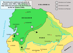
By the terms of the Protocol, Ecuador agreed to withdraw its long-standing claim for rights to direct land access to the Marañon
and Amazon
rivers; Peru agreed to withdraw Peruvian military forces from Ecuadorian territory. An area of 200000 km² (77,220.4 sq mi) of hitherto disputed territory in the Maynas region of the Amazonian basin was awarded to Peru, which had been established to be the de facto
possessor of the land since the end of the 19th century. The "status quo" line defined in the 1936 Lima Accord was used as the basis for the definitive border line; the previous border recognized current possessions, but not sovereignty
. Relative to the 1936 line, Ecuador ceded 18,552 km² of previously possessed territory to Peru, while Peru ceded 5,072 km² of previously possessed territory to Ecuador.
acting as lead. One of them, which involved the then contested Cordillera del Cóndor, was submitted to arbitration by Captain Braz Dias de Aguiar. Both countries initially accepted the arbiter's award, issued July 1945, and demarcation began in the area according to that ruling.
During 1943 and 1946 the United States Air Force
performed several aerial reconnaissance missions over the Cordillera del Cóndor region (losing 2 aircraft and 14 men in accidents.) to help in the demarcation efforts. They found that the Cenepa river was much longer than previously thought and that it runs between the Zamora
and the Santiago
. This finding conflicted with article VIII, point B-1 of the Rio Protocol, which laid out delineation of the border for that area as follows:
The difficulty was that there is not one watershed between the Zamora and the Santiago, but two, as interpreted by Ecuador. This resulted in Ecuadorian president Galo Plaza
halting demarcation in 1949. About 78 kilometers of border were left unmarked. In 1953 Ecuador withdrew from the Demarcation Commissions, claiming the Protocol "impossible to implement" in that area.
On September 29, 1960 Ecuadorian president José María Velasco Ibarra
declared the Rio Protocol null and void. (Peruvian analysts have speculated that this was a politically motivated move by Velasco Ibarra, who was considered a populist, but evidence to support this assertion is totally circumstantial).
With the sole exception of Cuba
, the American community did not approve of Ecuador's diplomatic move, with the United States sending a letter of protest to Ecuador.
The arguments for what is called Ecuador's thesis of nullity varied, but they were generally the following:
Peru's counter-arguments included the following:
Ecuador argued its thesis extensively for 30 years, but did not find support in the international community. Peru's position, on the other hand, was that a dispute did not exist at all after 1941, a position which lasted until 1995, when it was recognized as a problematic diplomatic issue.
Maps published in Ecuador since the 1960s up to the end of the 20th century officially had to exclude the unmarked 78 kilometers of border, that is, the Rio Protocol line was drawn as unresolved, and to include what Ecuador considered as its own by right, according to the Pedemonte-Mosquera protocol (1830) line, which puts the Marañon
(Amazon
) river as the border between Peru and Ecuador.
Such controversial maps of Ecuador, known in Ecuador as "Tufiño's map", were referred in Peru as "mapa recortado del Peru" (cut-off map of Peru).
One of the declaration's clauses included the creation the Military Observer Mission Ecuador-Peru (MOMEP) in order
to verify ceasefire agreements, observe and report infractions
through diplomatic channels.
The MOMEP contingent was made up
of observers, logistics, and aviation support from the United States
,
Argentina
, Brazil
, and Chile
as part of Operation Safe Border.
The mission, unique in its scope, was fully funded by Peru and Ecuador.
MOMEP was largely successful despite several tragic accidents due to
land mines left in the area.
At a critical moment during late July and early August 1998 it appeared that Peruvian forces were preparing a preemptive assault on Ecuadorian forces (this is partially believed due to the Peruvian airforce buying 19 Mig-29S and 18 Sukhoi-25 aircraft from Bielorussia to counter the abysmal state the airforce was at the beginning of the conflict, with 80% of the fleet grounded due to lack of spares), but the presence of the MOMEP contingent was instrumental in defusing the
situation. http://66.218.69.11/search/cache?p=ecuador+peru+1995+arbitration&toggle=1&ei=UTF-8&u=www.bu.edu/ihi/site_links/ihi_media_archive/downloads/peru.pdf&w=ecuador+peru+1995+arbitration&d=eV6CtGFULtkC&icp=1&.intl=us
The guarantors assisted the parties in ministerial level discussions aimed
at identifying the significant claims and disagreements of each side.
Both countries agreed to a guarantor-sponsored technical commission composed
of boundary experts in order to resolve the matter.
Before a critical meeting planned in Brazil for early 1997, both countries
entered a period of unforeseen political events. In Peru, there was a hostage
crisis in its Japanese embassy
involving guerrillas of the Túpac Amaru Revolutionary Movement
. Ecuador was going through a period of political instability as
President Abdala Bucaram
, a strong supporter of an agreement on the border
issue, was removed by congress due to alleged mental incapacity. (President Bucaram, who is known for his unusual antics, had visited Peru and was seen on TV eating ceviche
and wearing alpaca hoods—a traditional indigenous outfit—along with President Alberto Fujimori
.)
These delays nevertheless gave the guarantors more time to come up with
a solution to the dispute. Eventually they concluded that a resolution
would not be possible without granting something to each party.
The commission recognized Ecuador's position on one small already demarcated section of the border, and Peru's position on the larger issue of the single watershed between the
Zamora and Santiago rivers. The latter was a blow to Ecuador's historic position,
and left Tiwintza
in Peruvian territory.
The solution the commission arrived was that an area of one square kilometer at the site of
the fiercest fighting, Tiwintza, on the Peruvian side of the border,
be granted to Ecuador as a non-sovereign private property. The site
could be used by Ecuador to erect a monument and fly their flag.
Even though neither country was completely satisfied with the solution,
they both accepted it, which was a significant diplomatic success.
The resolution also called for the creation of two national parks
contiguous to one another (also referred to as a binational park)
in the Cordillera del Condor region.
Ambassador Luigi Einaudi, the US guarantor representative, is credited with coming
up with the idea of a private property concession in Tiwintza, working almost full time
on the problem, and coming up with ways to express issues in a manner not offensive
to either party. http://www.bu.edu/ihi/site_links/ihi_media_archive/downloads/peru.pdf#search='ecuador%20peru%201995%20arbitration'
On October 26, 1998, these two nations signed a comprehensive peace accord establishing the framework for ending a border dispute. Formal demarcation of border regions started on May 13, 1999. The agreement was ratified without opposition by both nations' congress. U.S. President Bill Clinton
said: "This signing marks the end of the last and longest running source of armed international conflict in the Western hemisphere".
Many examples of bias are cited, which can typically be characterized as removal of critical information about the other side's position. Emotional and nationalistic coloring of the material also appears to be routine. Although expected under the circumstances, this has likely fed the cycle of conflict in the past.
Citizens of Ecuador and Peru feel both their countries have lost territory over time. The issue is one of overlapping maximalist territorial claims and aspirations.
Many Peruvians, for example, believe that their country is related with the Inca Empire
, and that compared to the Tahuantinsuyo, is relatively small. At one point, the Viceroyalty of Peru
contained most of South America. The Republic of Peru lost territorial claims to Bolivia
(formerly known as Upper Peru
), Brazil
(Acre
and other Amazon territory), Colombia
(Leticia
province) and Chile
(Arica province and Tarapaca). Ecuadorians see their country as a continuation of what was the Real Audiencia de Quito, containing territories that are now parts of Peru and Colombia, reaching Brazil to the east.
High Peruvian military spending is seen by Ecuador as evidence of belligerence and expansionism. Peru also considers Ecuador belligerent and expansionist.
At the end of the 20th century things appear to have improved considerably. Ecuador's partial military success in the Cenepa War
of 1995 allowed an honorable resolution of the conflict without a clear winner. To many Ecuadorians this was viewed as restoring the honor of the country, which was at least as important as their claims to the disputed territory. Unfortunately, not everyone is completely satisfied.
One example of this is the fact that in Peru there are still some who believe Ecuador shouldn't have been given perpetual private property rights over the single km² spot of land known as Tiwintza
, which saw some of the most fierce fighting during the war of 1995. In time, more progressive views have found their way in the public discourse. More significantly perhaps, by the 1990s both nations had become exhausted by the endless dispute, and were more interested in finding a definitive negotiated solution to the border problem than ever before.
Today, the entire Ecuadorian-Peruvian border is clearly delimited and demarcated, and the maps of both countries agree on the location of the common frontier. Bilateral work is being done by both countries Foreign Affairs officers to consolidate the economic and social integration. We can see part of this done by the Peruvian government with their Consulate in Machala, El Oro, where Minister Efrain Saavedra
is the Consul General.
, has said peace is essential to South America's economic recovery. He added: "You clearly cannot have long-term growth and prosperity involving foreign investment without stability". http://news.bbc.co.uk/2/hi/americas/201442.stm While there are still political instability issues in the region, resolution of the territorial conflict is helpful.
Trade between both countries has benefited considerably. Before signing the peace treaty, annual trade between Peru and Ecuador was about 100 million dollars. But as early as 1998, it had increased 5-fold. http://www.fujimorialberto.com/index.php?selection=artAll&articleId=1038
There was also a broad agreement of integration between both countries. http://www.opanal.org/Articles/Seminar-Lima/cabezas_lima_e.htm http://planbinacional.rree.gob.pe/domino/nsf/planbinacional.nsf/0/B773348FF71A8F9C05256F5D007779A0?OpenDocument It included a binational fund for peace and development, national plans for productive, social and environmental development, and so on.
), as
a result of the Ecuadorian-Peruvian territorial dispute "a number
of emerging views about international affairs, U.S. foreign policy, and modern
inter-American affairs were either shattered or seriously challenged". http://www.dtic.mil/doctrine/jel/research_pubs/amazon.pdf Some of the
global and regional political implications of the dispute which have been
noted are the following:
Territorial dispute
A territorial dispute is a disagreement over the possession/control of land between two or more states or over the possession or control of land by a new state and occupying power after it has conquered the land from a former state no longer currently recognized by the new state.-Context and...
between Ecuador
Ecuador
Ecuador , officially the Republic of Ecuador is a representative democratic republic in South America, bordered by Colombia on the north, Peru on the east and south, and by the Pacific Ocean to the west. It is one of only two countries in South America, along with Chile, that do not have a border...
and Peru
Peru
Peru , officially the Republic of Peru , is a country in western South America. It is bordered on the north by Ecuador and Colombia, on the east by Brazil, on the southeast by Bolivia, on the south by Chile, and on the west by the Pacific Ocean....
was the source of the longest-running international armed conflict in the Western Hemisphere. This dispute was a consequence of the imprecise geographical definitions used in colonial times to define the limits of the Royal Audiences; after Peru and neighboring Gran Colombia
Gran Colombia
Gran Colombia is a name used today for the state that encompassed much of northern South America and part of southern Central America from 1819 to 1831. This short-lived republic included the territories of present-day Colombia, Venezuela, Ecuador, Panama, northern Peru and northwest Brazil. The...
proclaimed independence from the Spanish crown in 1821 and 1819, respectively, this dispute led to the war of 1828. In the aftermath, the belligerent parties agree to proclaim their limits in the basis of the principle "Utis Posedetis" and the border became the one that existed between the Spanish viceroyalties of Peru
Viceroyalty of Peru
Created in 1542, the Viceroyalty of Peru was a Spanish colonial administrative district that originally contained most of Spanish-ruled South America, governed from the capital of Lima...
and New Granada
Viceroyalty of New Granada
The Viceroyalty of New Granada was the name given on 27 May 1717, to a Spanish colonial jurisdiction in northern South America, corresponding mainly to modern Colombia, Ecuador, Panama, and Venezuela. The territory corresponding to Panama was incorporated later in 1739...
.
When the Republic of Ecuador proclaimed its secession
Secession
Secession is the act of withdrawing from an organization, union, or especially a political entity. Threats of secession also can be a strategy for achieving more limited goals.-Secession theory:...
from Gran Colombia in 1830 its government negotiated a swap of territories in the Amazon basin for debt with the British creditors, and the dispute over the territories re-ignited in 1857. Peru implemented a maritime blockade
Blockade
A blockade is an effort to cut off food, supplies, war material or communications from a particular area by force, either in part or totally. A blockade should not be confused with an embargo or sanctions, which are legal barriers to trade, and is distinct from a siege in that a blockade is usually...
of the port of Guayaquil
Guayaquil
Guayaquil , officially Santiago de Guayaquil , is the largest and the most populous city in Ecuador,with about 2.3 million inhabitants in the city and nearly 3.1 million in the metropolitan area, as well as that nation's main port...
demanding a revocation of the deal, as well as an acknowledgment of Peruvian sovereignty over the disputed territories. These demands went unheeded and with Ecuador in a state of civil war, the government of Guillermo Franco
Guillermo Franco (Ecuadorian general)
Guillermo Franco was an Ecuadorian general.From a young age, Franco was interested in becoming a military man. He could not participate in the Revolution of October 9, 1820 due to his young age, but soon thereafter enrolled at the Nautical School founded by Admiral Illingworth...
in the province of Guayaquil, claiming to represent the entire country, agreed to Peru's demands and signed the Treaty of Mapasingue
Mapasingue
Mapasingue is a barrio of the city of Guayaquil, Ecuador. Mapasingue was an hacienda in the 19th century; in November 1859, a Peruvian army contingent occupied its lands as a result of an agreement between Peruvian President Ramon Castilla and Supreme Chief of Guayas Guillermo Franco, in the...
of 1860. Gabriel García Moreno
Gabriel García Moreno
Gabriel Gregorio Fernando José María García y Moreno y Morán de Buitrón was an Ecuadorian statesman who twice served as President of Ecuador and was assassinated during his second term, after being elected to a third term...
's provisional government won the civil war later that year, and voided this treaty, with the new Peruvian government following suit several years later.
The dispute continued through the late 19th century and beginning of the 20th century. Numerous attempts were made to define the borders, but both governments could not deal to an agreement acceptable to their constituencies. A war between Colombia and Peru occurred during 1932 and 1933 in the Eastern region of the Amazon territories and resulted in the official designation of the Putumayo River
Putumayo River
The Içá or Putumayo River is one of the tributaries of the Amazon River, west of and parallel to the Yapura. It forms part of Colombia's border with Ecuador, as well as most of the frontier with Peru...
as a border between Colombia and Peru; but sectors of the society considered this detrimental to the Ecuadorian cause, with Colombia now recognizing Peru's rights to the territory that Ecuador claimed as its own. An agreement recognizing territories in de facto
De facto
De facto is a Latin expression that means "concerning fact." In law, it often means "in practice but not necessarily ordained by law" or "in practice or actuality, but not officially established." It is commonly used in contrast to de jure when referring to matters of law, governance, or...
possession by each country was signed in 1936, but minor military skirmishes began to occur in 1938. Tensions escalated, and war broke out in July 1941, and officially came to an end with the signing of the Rio de Janeiro Protocol
Rio Protocol
The Protocol of Peace, Friendship, and Boundaries between Peru and Ecuador, or Rio Protocol for short, was an international agreement signed in Rio de Janeiro, Brazil, on January 29, 1942, by the foreign ministers of Peru and Ecuador, with the participation of the United States, Brazil, Chile, and...
on January 29, 1942. The treaty was intended to finally bring the long-running territorial dispute to an end, but in 1960 the then president of Ecuador Dr. José Mª Velasco Ibarra proposed to the Congress a thesis of nullity based in the fact that the 1942 protocol was forced unto the Ecuadorian government under duress.
A brief military clash took place in early 1981, when the Peruvian Army
Peruvian Army
The Peruvian Army is the branch of the Peruvian Armed Forces tasked with safeguarding the independence, sovereignty and integrity of national territory on land through military force. Additional missions include assistance in safeguarding internal security, conducting disaster relief operations...
forcefully took control of three Ecuadorian military outposts on the eastern slopes of the Cordillera del Cóndor
Cordillera del Cóndor
The Cordillera del Condor is a range in Ecuador and Peru....
mountain range. An agreement in 1992 between the presidents of the two countries promised to seek peaceful resolution to the conflict. However, in December 1994, the Ecuadorian army was seen to be mobilizing in the vicinity of the Cordillera del Cóndor. On January 26, 1995, war broke out
Cenepa War
The Cenepa War , also known as the Alto Cenepa War, was a brief and localized military conflict between Ecuador and Peru, fought over control of a disputed area on the border between the two countries...
over control of several outposts located on the headwaters of the Cenepa River
Cenepa River
The Cenepa River rises in the Condor mountain range in Peru, South America and has a length of 185 km. It borders to the North on Ecuador, to the East on the districts of Río Santiago and Nieva, on the South with the district of Imaza, and on the West with Ecuador....
, within a 78-kilometer strip of territory that both countries claimed as their own. In contrast to previous encounters, which had resulted in favorable outcomes for Peru, Ecuador was able to claim limited but emotionally significant tactical success, retaining control of the embattled outpost of Tiwinza and wresting local air superiority from the Peruvian Air Force
Peruvian Air Force
The Peruvian Air Force is the branch of the Peruvian Armed Forces tasked with defending the nation and its interests through the use of air power...
. The fighting came to an end after just over one month, with the signing of the Montevideo Declaration on February 28, and the later signing of the Itamaraty Peace Declaration under the supervision of the guarantors of the Rio Protocol of 1942: Argentina
Argentina
Argentina , officially the Argentine Republic , is the second largest country in South America by land area, after Brazil. It is constituted as a federation of 23 provinces and an autonomous city, Buenos Aires...
, Brazil
Brazil
Brazil , officially the Federative Republic of Brazil , is the largest country in South America. It is the world's fifth largest country, both by geographical area and by population with over 192 million people...
, Chile
Chile
Chile ,officially the Republic of Chile , is a country in South America occupying a long, narrow coastal strip between the Andes mountains to the east and the Pacific Ocean to the west. It borders Peru to the north, Bolivia to the northeast, Argentina to the east, and the Drake Passage in the far...
, and the U.S.
Tensions subsided but persisted over the next three years. On October 26, 1998, Ecuador and Peru signed a comprehensive peace accord that established a framework for ending a border dispute. Formal demarcation of border regions started on May 13, 1999. The agreement was ratified without opposition by the congresses of both nations, finally bringing an end to the dispute, almost two centuries after the South American nations (or their predecessors) claimed their independence from the Spanish Crown.
Spanish conquest and establishment of the Viceroyalty of Peru
Beginning with the arrival of Christopher ColumbusChristopher Columbus
Christopher Columbus was an explorer, colonizer, and navigator, born in the Republic of Genoa, in northwestern Italy. Under the auspices of the Catholic Monarchs of Spain, he completed four voyages across the Atlantic Ocean that led to general European awareness of the American continents in the...
in 1492, the Spanish conquistadores expanded the range of the Spanish Crown's
Crown of Castile
The Crown of Castile was a medieval and modern state in the Iberian Peninsula that formed in 1230 as a result of the third and definitive union of the crowns and parliaments of the kingdoms of Castile and León upon the accession of the then King Ferdinand III of Castile to the vacant Leonese throne...
reach from early small settlements in the Caribbean to various continental territories, eventually including Central America
Central America
Central America is the central geographic region of the Americas. It is the southernmost, isthmian portion of the North American continent, which connects with South America on the southeast. When considered part of the unified continental model, it is considered a subcontinent...
and most of South America
South America
South America is a continent situated in the Western Hemisphere, mostly in the Southern Hemisphere, with a relatively small portion in the Northern Hemisphere. The continent is also considered a subcontinent of the Americas. It is bordered on the west by the Pacific Ocean and on the north and east...
.
The Spaniards arrived at the borders of the Inca Empire
Inca Empire
The Inca Empire, or Inka Empire , was the largest empire in pre-Columbian America. The administrative, political and military center of the empire was located in Cusco in modern-day Peru. The Inca civilization arose from the highlands of Peru sometime in the early 13th century...
in 1528, and on November 16, 1532, taking advantage of the Inca Civil War
Inca Civil War
The Inca Civil War, the Inca Dynastic War, the Inca War of Succession, or, sometimes, the War of the Two Brothers was fought between two brothers, Huáscar and Atahualpa, sons of Huayna Capac, over the succession to the Inca throne. The war followed Huayna Capac's death in 1527, although it did not...
, the tiny army of Francisco Pizzaro began the Spanish conquest of Peru. In the following decades, Spain consolidated its power over the entire Andean region, repressing successive indigenous rebellions.
To govern the new territories of Spain, in 1542 Holy Roman Emperor
Holy Roman Emperor
The Holy Roman Emperor is a term used by historians to denote a medieval ruler who, as German King, had also received the title of "Emperor of the Romans" from the Pope...
Charles V
Charles V, Holy Roman Emperor
Charles V was ruler of the Holy Roman Empire from 1519 and, as Charles I, of the Spanish Empire from 1516 until his voluntary retirement and abdication in favor of his younger brother Ferdinand I and his son Philip II in 1556.As...
(King Charles I of Spain) created two Viceroyalties, the Viceroyalty of New Spain (in modern-day Mexico
Mexico
The United Mexican States , commonly known as Mexico , is a federal constitutional republic in North America. It is bordered on the north by the United States; on the south and west by the Pacific Ocean; on the southeast by Guatemala, Belize, and the Caribbean Sea; and on the east by the Gulf of...
) and the Viceroyalty of Peru
Viceroyalty of Peru
Created in 1542, the Viceroyalty of Peru was a Spanish colonial administrative district that originally contained most of Spanish-ruled South America, governed from the capital of Lima...
(a.k.a. the Viceroyalty of New Castile). In 1542, King Charles named Blasco Núñez Vela
Blasco Núñez Vela
Blasco Núñez Vela y Villalba was the first Spanish viceroy of Peru, from May 15, 1544 to January 18, 1546. He was charged by King Charles I with the enforcement of the controversial New Laws, which dealt with the failure of the encomienda system to protect the indigenous people of America from the...
Peru's first viceroy, but the viceroyalty was not organized until the arrival of Viceroy Francisco de Toledo
Francisco de Toledo, Count of Oropesa
Francisco Álvarez de Toledo, Count of Oropesa was Spanish viceroy of Peru from November 26, 1569 to September 23, 1581.-Early years:...
in 1572. Toledo promptly declared war on Vilcabamba
Vilcabamba, Peru
Vilcabamba was a city founded by Manco Inca in 1539 and was the last refuge of the Inca Empire until it fell to the Spaniards in 1572, signaling the end of Inca resistance to Spanish rule.- History :...
, the last refuge of the Inca; soon afterwards, Tupac Amaru
Túpac Amaru
Túpac Amaru, also called Thupa Amaro , was the last indigenous leader of the Inca state in Peru.-Accession:...
, the last Inca emperor, was captured and executed in Cuzco.
Territorial division of the Viceroyalty of Peru
Real Audiencia of Lima
The Royal Audiencia and Chancery of Lima was a superior court in the New World empire of Spain, located in the city of Lima, capital of the Viceroyalty of Peru. It was created on November 20, 1542 as was the viceroyalty itself, by the Emperor Charles V...
and Santo Domingo
Real Audiencia of Santo Domingo
The Royal Audiencia of Santo Domingo was the first court of the Spanish crown in America. It was created by Ferdinand V of Castile in his decree of 1511, but due to disagreements between the governor of Hispaniola, Diego Colon and the Crown, it was not implemented until it was reestablished by...
, Peru (as well as New Spain) was divided into a number of real audiencias (royal audiences), a type of superior judicial tribunal that combined executive and judicial authority, and can be considered "major province
Province
A province is a territorial unit, almost always an administrative division, within a country or state.-Etymology:The English word "province" is attested since about 1330 and derives from the 13th-century Old French "province," which itself comes from the Latin word "provincia," which referred to...
s". The audiences controlled the gobernaciones,Defined as "the civil, as distinguished from the military, branch of the colonial governmental entities lesser in extent than the audiencias." (1910) alcaldias mayores,Defined as "the jurisdiction of the Alcalde mayor, who, as mayor, governed a town of lesser importance than the capital of a province." (1910) corregimientos,Defined as "the district governed by a Corregidor, a correctional magistrate, who, in colonial times, exercised administrative functions over a district. (1910) and alcaldias ordinarias.Defined as "jurisdiction of the Alcalde ordinario, who was similar to the alcaldia mayor, but of lesser extent. (1910) The territory was also divided ecclesiastically, into archbishoprics, religious provinces, suggragan bishopries, parishes and curateships. The archbishoprics and religious provinces corresponded with the audiences, the bishoprics with the gobernaciones and alcaldias mayores, and the parishes and curateships with the corregimientos and alcaldias ordinarias.
These civil divisions were not uniform, with numerous exceptions being made based on the specific circumstances. The Viceroys were presidents of the audiences at the capitals of their Viceroyalties, with other audiences being presided over by captains-generals, or by persons known as gowned presidents. Power was devolved to the captains-general of an audience by the Viceroy, and the audience's territory was administered by the audience's president and the political, military, and religious officials underneath him.
Between 1542 and 1717, the Viceroyalty controlled most of the territory of South America (save for a few non-Spanish colonies and the Commandancy General of Caracas
Caracas
Caracas , officially Santiago de León de Caracas, is the capital and largest city of Venezuela; natives or residents are known as Caraquenians in English . It is located in the northern part of the country, following the contours of the narrow Caracas Valley on the Venezuelan coastal mountain range...
, which was a dependency of the Captaincy General of Santo Domingo). The territory was divided among (noting dates of creation):
- Royal Audience of Tierra Firme (1564)
- Royal Audience of Santa Fe de Bogotá (1548)
- Royal Audience of San Francisco of QuitoRoyal Audience of QuitoThe Royal Audience of Quito was an administrative unit in the Spanish Empire which had political, military, and religious jurisdiction over territories that today include Ecuador, parts of northern Peru, parts of southern Colombia and parts of northern Brazil...
(1563) - Royal Audience of the City of Kings LimaReal Audiencia of LimaThe Royal Audiencia and Chancery of Lima was a superior court in the New World empire of Spain, located in the city of Lima, capital of the Viceroyalty of Peru. It was created on November 20, 1542 as was the viceroyalty itself, by the Emperor Charles V...
(1543) - Royal Audience of La Plata de los Charcas (1559)
- Royal Audience of ChileReal Audiencia of ChileRoyal Audience of Santiago :-Structure:Law XII of Title XV of Book II of the Recopilación de Leyes de las Indias of 1680—which reproduces Philip IV's decree of February 17, 1609—describes the limits and functions of the Audiencia.In the city of Santiago de Chile shall...
(1563–1573; 1606, sometimes referred to as the Kingdom of ChileKingdom of ChileThe General Captaincy of Chile or Gobernacion de Chile, was an administrative territory of the Viceroyalty of Peru in the Spanish Empire from 1541 to 1818, the year in which it declared itself independent, becoming the Republic of Chile...
)
The district of an audience was established in the royal decree by which it was created; the laws laid out in the myriad of Cédulas Reales issued by the Spanish Crown were compiled several times throughout the centuries-long history of Spanish presence in the region. These compilations were referred to as the Laws of the Indies
Laws of the Indies
The Laws of the Indies are the entire body of laws issued by the Spanish Crown for its American and Philippine possessions of its empire. They regulated social, political and economic life in these areas...
; the 1680 compilation, organized under Charles II, known as the Recopilación de las Leyes de los Reynos de Indias (Compilation of the Laws of the Kingdoms of the Indies), set a template by which the laws were organized.
Under Title XV of Book II of the Recopilación, the limits of the audiences of Lima and Quito were defined as follows:
Creation of the Viceroyalty of New Granada
The two original Spanish viceroyalties of New Spain and Peru had existed intact up until 1717, when King Philip V of SpainPhilip V of Spain
Philip V was King of Spain from 15 November 1700 to 15 January 1724, when he abdicated in favor of his son Louis, and from 6 September 1724, when he assumed the throne again upon his son's death, to his death.Before his reign, Philip occupied an exalted place in the royal family of France as a...
issued the Real Cédula of May 27, 1717. The order split off the northwestern corner of Peru and created the Viceroyalty of New Granada
Viceroyalty of New Granada
The Viceroyalty of New Granada was the name given on 27 May 1717, to a Spanish colonial jurisdiction in northern South America, corresponding mainly to modern Colombia, Ecuador, Panama, and Venezuela. The territory corresponding to Panama was incorporated later in 1739...
. New Granada shared its capital with the Royal Audience of Santa Fé de Bogotá, and additionally had jurisdiction over the New Kingdom of Granada
New Kingdom of Granada
The New Kingdom of Granada was the name given to a group of 16th century Spanish colonial provinces in northern South America governed by the president of the Audiencia of Bogotá, an area corresponding mainly to modern day Colombia and parts of Venezuela. Originally part of the Viceroyalty of...
, as well as the audiences of Tierra Firme (now called Panama), Quito, and the Captaincy General of Venezuela
Captaincy General of Venezuela
The Captaincy General of Venezuela was an administrative district of colonial Spain, created in 1777 to provide more autonomy for the provinces of Venezuela, previously under the jurisdiction of the Viceroyalty of New Granada and the Audiencia of Santo Domingo...
. The territories of the Viceroyalty comprised the territories of, respectively, the modern Republics of Colombia, Ecuador
Ecuador
Ecuador , officially the Republic of Ecuador is a representative democratic republic in South America, bordered by Colombia on the north, Peru on the east and south, and by the Pacific Ocean to the west. It is one of only two countries in South America, along with Chile, that do not have a border...
, Panama
Panama
Panama , officially the Republic of Panama , is the southernmost country of Central America. Situated on the isthmus connecting North and South America, it is bordered by Costa Rica to the northwest, Colombia to the southeast, the Caribbean Sea to the north and the Pacific Ocean to the south. The...
, and Venezuela
Venezuela
Venezuela , officially called the Bolivarian Republic of Venezuela , is a tropical country on the northern coast of South America. It borders Colombia to the west, Guyana to the east, and Brazil to the south...
, as well as the northern regions of Peru
Peru
Peru , officially the Republic of Peru , is a country in western South America. It is bordered on the north by Ecuador and Colombia, on the east by Brazil, on the southeast by Bolivia, on the south by Chile, and on the west by the Pacific Ocean....
, the Brazil
Brazil
Brazil , officially the Federative Republic of Brazil , is the largest country in South America. It is the world's fifth largest country, both by geographical area and by population with over 192 million people...
ian northwest, and the western part of Guyana
Guyana
Guyana , officially the Co-operative Republic of Guyana, previously the colony of British Guiana, is a sovereign state on the northern coast of South America that is culturally part of the Anglophone Caribbean. Guyana was a former colony of the Dutch and of the British...
.
The Royal Audience of Quito had been established by a royal decree in 1563, its territory including Pasto
Pasto
Pasto, officially San Juan de Pasto, is the capital of the department of Nariño, located in southwest Colombia. The city is located in the "Atriz Valley", on the Andes cordillera, at the foot of the Galeras volcano, at an altitude of 8,290 feet above sea level...
, Popayán
Popayán
Popayán is the capital of the Colombian department of Cauca. It is located in southwestern Colombia between Colombia's Western Mountain Range and Central Mountain Range...
, Cali
Calì
Calì, also written in English as Cali, is an Italian surname, widespread mainly in the Ionian side of Sicily.For the surname Calì is assumed the origin of the Greek word kalos , or from its Sanskrit root kali, "time."The surname refers to:...
, Buenaventura
Buenaventura
-Myths and legends:*Buenaventura River , a legendary but non-existent river that was once believed to run from the Rocky Mountains to the Pacific Ocean in what is now the western United States-People:...
and Buga
Buga
Buğa or Boğa means "bull" in Turkic languages, also transliterated as Bugha, or Buqa . It may refer to one of the following persons.*Tala Buga, the khan of Golden Horde between 1287 and 1291...
in what is currently Colombia
Colombia
Colombia, officially the Republic of Colombia , is a unitary constitutional republic comprising thirty-two departments. The country is located in northwestern South America, bordered to the east by Venezuela and Brazil; to the south by Ecuador and Peru; to the north by the Caribbean Sea; to the...
, and extended as far south as Piura
Piura
Piura is a city in northwestern Peru. It is the capital of the Piura Region and the Piura Province. The population is 377,496.It was here that Spanish Conqueror Francisco Pizarro founded the third Spanish city in South America and first in Peru, San Miguel de Piura, in July 1532...
in what is now Peru
Peru
Peru , officially the Republic of Peru , is a country in western South America. It is bordered on the north by Ecuador and Colombia, on the east by Brazil, on the southeast by Bolivia, on the south by Chile, and on the west by the Pacific Ocean....
. The eastern limit was ill-defined at the time, due to a lack of geographical knowledge and the low importance given to unpopulated, hard-to-reach territories.
Having temporarily suppressed the Viceroyalty of New Granada, on November 5, 1723, Philip V emitted another Cédula, which returned control of the Royal Audience of Quito to the Viceroyalty of Peru. The Cédula of August 20, 1739 (also called the Cédula de Reerección Definitiva del Virreinato de Nueva Granada, "Definitive Decree of Re-erection of the Viceroyalty of New Granada") reinstated the viceroyalty with its 1717 territories, including the Royal Audience of Quito. The border between Quito and the Viceroyalty of Peru was defined in 1740 by another Cédula:
This cedula greatly modified the original demarcation, but served only to fix the starting point of the line on the pacific coast at the river Tumbes. This document was the first mention of the Tumbes as the boundary between the two viceroyalties.
Real Cedula of 1802
Don Francisco de Requena requested that control of the Government and Commandancy General of Maynas pass from the Viceroyalty of Santa Fe (New Granada) to the Viceroyalty of Peru. In response, on July 15, 1802, the Spanish crown under the rule of Charles IV of SpainCharles IV of Spain
Charles IV was King of Spain from 14 December 1788 until his abdication on 19 March 1808.-Early life:...
issued the Real Cédula of 1802. The decree split the Government and Commandancy General of Maynas
Maynas Province
Maynas is a province in the Loreto Region in northeastern Peru. Its capital, Iquitos, is also Loreto's regional capital and the largest city in the Peruvian Amazon Rainforest.-Boundaries:...
and the Government of Quijos
Quijos Canton
Quijos Canton is a canton of Ecuador, located in the Napo Province. Its capital is the town of Baeza. Its population at the 2001 census was 5,505....
from the Audience of Quito, and added them to the Viceroyalty of Peru. The text of the decree, as reproduced in the Annals of the diplomatic and consular missions of Colombia (1901), reads:
In a footnote, Dr. Antonio José Uribe, Minister of Foreign Affairs of Colombia
Ministry of Foreign Affairs (Colombia)
The Ministry of Foreign Affairs also known as the Chancellery, is the national executive ministry of the Government of Colombia responsible for the foreign relations of Colombia through its diplomatic missions abroad by formulating foreign policy relevant to the matters of the State, it is...
from 1901 to 1902, wrote,
thereby casting suspicion on the authenticity of one or more of the copies of the document, complicating the already difficult matter of interpreting its meaning.Bowman, p.759: "A royal cedula, dated 1802, complicated matters ... [there] was considerable uncertainty as to the validity of the cedula as well as its meaning..." (This paper was published in 1942, and establishes uncertainty of the Cedula's authenticity at least up until that date.)
According to Pedro Moncayo y Esparza, a 19th-century Ecuadorian writer, the Viceroy of Santa Fe and the President of Quito objected to the execution of the Real Cédula of 1802, as it had all the makings of an apocryphal document: it was not registered in the official cedulario, and its contents could not be found in the Recopilacion de Indias, nor had it been located in the Archive of the Indies in Spain
Spain
Spain , officially the Kingdom of Spain languages]] under the European Charter for Regional or Minority Languages. In each of these, Spain's official name is as follows:;;;;;;), is a country and member state of the European Union located in southwestern Europe on the Iberian Peninsula...
. However, during the Peruvian congressional committee hearings regarding the dismissal of the Treaty of Mapasingue, signed between Ecuador and Peru at the end of the dispute of 1857-1860, it was stated that the Real Cédula of 1802 and the documents proving its execution were found in the archives of the ancient government of Maynas.
The lack of clarity within the document as to whether the transfer of administrative power was purely military and ecclesiasticcal in nature, or territorial as well, formed the basis for an imprecise territorial situation between Ecuador and Peru when the two nations obtained their independence from Spain.
1803-1818
- 1803: A similar event occurred in 1803, when it was decided that the military affairs of the Province of Guayaquil (whose capital was the strategically situated port city of GuayaquilGuayaquilGuayaquil , officially Santiago de Guayaquil , is the largest and the most populous city in Ecuador,with about 2.3 million inhabitants in the city and nearly 3.1 million in the metropolitan area, as well as that nation's main port...
) would be run from Lima.
- 1810: all administrative and economic affairs of the province were turned over to the Viceroyalty of Peru, a state of affairs that would endure until 1819. Jaen de Bracamoros had no such cedula transferring it to Peru and would rightly belong to Ecuador. However, Jaen decided to join Peru after it took part in northern Peru's revolutionary wars of independence.-->
- September 28, 1812: the Council of Regency requested from Madrid the Expediente sobre la erección del Obispado de Maynas y las Cédulas que se expedieron en 1805 acerca de los limites ("File on the erection of the Diocese of Maynas and the Decrees that were issued in 1805 regarding the borders"). With no response forthcoming, a Decree of the Courts rendered the Decree of 1802 null and void on November 13, 1812.
- September 13, 1813: the Real Cédula de 1813 was issued to replace the 1802 decree, in its first article ordering "entregar al Ordinario las nuevas Reducciones y Doctrinas que tuviesen mas de 10 años de antiguedad, proveyéndose en eclesiásticos seculares, conforme a las Leyes del Patronato. "
- September 26, 1813: the Bishop of Maynas, Friar Hipólito Sánchez Rangel, notifies the Overseas Minister that "solo assisten los Religiosos de Quito en Maynas y dice es fuerza, pues, si se tratan de hacer justicia que se me ponga en otro Obispado que sea menos penoso."
- May 1, 1814: the census carried out by Sanchez Rangel reads: in 58 towns of the 90 that make up said diocese there are no more than eight assistant priests, three of which are located at the extremes of the Bishopric: three in small rivers, one in the dilated course of the great rivers Guallaga and Marañon, and none in the Napo, Putumayo, Ucayale and Pastaza. This mean that 60 villages were without a parish and almost all the missions were abandoned. Sanchez Rangel had written in 1813: "Desde que salieron los jesuitas de estas tierras no ha habido quien se contraiga a su fomento espiritual ni temporal; todos se han buscado a sí mismos. De esta proposición que es absoluta y de una eterna verdad se ha seguido naturalmente lo que estamos viendo y tocando con dolor, que ya no ha quedado cosa alguna de lo que aquellos padres establecieron y solo hay lo que produce la madre naturaleza."
- September 27, 1814: Sanchez Rangle requests that the Bishopric of Maynas be suppressed, its erection null and void due to a lack of compliance with the Real Cédula de 1802.
- February 22, 1815: The Council of the Indies receives a letter from Sanchez Rangel dated January 28, 1814. Bishop Rangel proves that the Decree of 1802 has not been met by the government, the priests at the edges of the Bishopric, nor the "P.P. de Ocopa".
- February 7, 1815: The President of Quito, Toribio Montes reports regarding the Missions of Maynas, saying "He manifesto a V.E. en informes anteriores, que las Missiones del Marañon se hallan en un sensible atraso, faltándoles el número completamente Ministros evangélicos...Incluye a Maynas en los dominios de Quito"
- 1816: The King of Spain issues a Royal Order revoking and annulling the Real Cédula de 1802; on September 22, the President of Quito receives the files related to the revocation.
- 1818: The President of Quito names Don Juan Navas Governor of Quijos. On June 19, the Council of the Indies tells the story of the creation of the Bishopric and the General Command of Maynas, the lack of compliance with the Decree of 1802, and the impossibility of compliance with the former.
- July 22, 1818: The President of Quito asks the Viceroy of Peru for the revocation and annulment of the Real Cédula de 1802. On August 23, the Viceroy acknowledges the Royal Order of 1816, returning the province of Maynas to Quito.
Independence from Spain
The Republic of Gran Colombia was founded in 1819, with Simón BolivarSimón Bolívar
Simón José Antonio de la Santísima Trinidad Bolívar y Palacios Ponte y Yeiter, commonly known as Simón Bolívar was a Venezuelan military and political leader...
as President. On August 7 of that year, the independence of what is now Colombia
Colombia
Colombia, officially the Republic of Colombia , is a unitary constitutional republic comprising thirty-two departments. The country is located in northwestern South America, bordered to the east by Venezuela and Brazil; to the south by Ecuador and Peru; to the north by the Caribbean Sea; to the...
was won in the Battle of Boyacá
Battle of Boyacá
The Battle of Boyacá in Colombia, then known as New Granada, was the battle in which Colombia acquired its definitive independence from Spanish Monarchy, although fighting with royalist forces would continue for years....
. The independence of Venezuela
Venezuela
Venezuela , officially called the Bolivarian Republic of Venezuela , is a tropical country on the northern coast of South America. It borders Colombia to the west, Guyana to the east, and Brazil to the south...
was won on June 24, 1821 in the Battle of Carabobo
Battle of Carabobo
The Battle of Carabobo, 24 June 1821, was fought between independence fighters, led by Simón Bolívar, and the Royalist forces, led by Spanish Field Marshal Miguel de la Torre. Bolívar's decisive victory at Carabobo led to the independence of Venezuela....
. One of Bolivar's generals, Venezuelan-born General Antonio José de Sucre
Antonio José de Sucre
Antonio José de Sucre y Alcalá , known as the "Gran Mariscal de Ayacucho" , was a Venezuelan independence leader. Sucre was one of Simón Bolívar's closest friends, generals and statesmen.-Ancestry:...
won the Battle of Pichincha
Battle of Pichincha
The Battle of Pichincha took place on 24 May 1822, on the slopes of the Pichincha volcano, 3,500 meters above sea-level, right next to the city of Quito, in modern Ecuador....
on May 24, 1822 and freed the territory that was then Ecuador.
Gran Colombia comprised what is now Colombia
Colombia
Colombia, officially the Republic of Colombia , is a unitary constitutional republic comprising thirty-two departments. The country is located in northwestern South America, bordered to the east by Venezuela and Brazil; to the south by Ecuador and Peru; to the north by the Caribbean Sea; to the...
, Ecuador
Ecuador
Ecuador , officially the Republic of Ecuador is a representative democratic republic in South America, bordered by Colombia on the north, Peru on the east and south, and by the Pacific Ocean to the west. It is one of only two countries in South America, along with Chile, that do not have a border...
, Venezuela
Venezuela
Venezuela , officially called the Bolivarian Republic of Venezuela , is a tropical country on the northern coast of South America. It borders Colombia to the west, Guyana to the east, and Brazil to the south...
and
Panama
Panama
Panama , officially the Republic of Panama , is the southernmost country of Central America. Situated on the isthmus connecting North and South America, it is bordered by Costa Rica to the northwest, Colombia to the southeast, the Caribbean Sea to the north and the Pacific Ocean to the south. The...
. It was Simón Bolivar's dream to unite all of South America, a project which he would never achieve.
Even before the battles for the freedom of the South American colonies were over, Bolivar established the uti possidetis juris
Uti Possidetis Juris
Uti possidetis juris is a principle of international law that states that newly formed sovereign states should have the same borders that their preceding dependent area had before their independence.-History:...
principle as the basis for the territorial demarcation of the new nation-states that were to be born out of the ancient colonial jurisdictions. In essence, the principle stated that the borders of the new countries should correspond to the Spanish administrative borders, as they were in 1809. This would present some difficulties due to lack of geographical knowledge, and also because much of the territory was unpopulated and unexplored. By this principle, the territory of the Viceroyalty of Peru would become part of Peru, and the territory of the Viceroyalty of New Granada part of Gran Colombia.
- July 6, 1822: Monteagudo-Mosquera Treaty
- Mosquera's mission to Lima had two objectives: (1) To come up with a treaty of alliance between Gran Colombia and Peru against Spain, and (2) To have Peru recognize that GuayaquilGuayaquilGuayaquil , officially Santiago de Guayaquil , is the largest and the most populous city in Ecuador,with about 2.3 million inhabitants in the city and nearly 3.1 million in the metropolitan area, as well as that nation's main port...
was to be part of Gran Colombia. Monteagudo initially refused to give up GuayaquilGuayaquilGuayaquil , officially Santiago de Guayaquil , is the largest and the most populous city in Ecuador,with about 2.3 million inhabitants in the city and nearly 3.1 million in the metropolitan area, as well as that nation's main port...
without first having the people of that city express their will voluntarily. The treaty was signed, nonetheless, but precise territorial demarcation was left for a later treaty . http://www.congreso.gob.pe/comisiones/1999/exteriores/Libroweb/cap2.htm
The Gran Colombia–Peru War
Bolivar had aspirations to be president for life of Gran ColombiaGran Colombia
Gran Colombia is a name used today for the state that encompassed much of northern South America and part of southern Central America from 1819 to 1831. This short-lived republic included the territories of present-day Colombia, Venezuela, Ecuador, Panama, northern Peru and northwest Brazil. The...
, a republic that would unite most of the former Spanish colonies under his rule. Peruvian President José de la Mar
José de la Mar
José de la Mar was a South American military leader.He was born in Cuenca in what today is Ecuador. He spent his early childhood in Spain, where he started his military career...
, who had been a member of Bolivar's troops during the wars of independence and born in Cuenca, Ecuador, had his own political ambition: to establish himself as the formal ruler of Peru. As a result, relations between Bolivar and de la Mar quickly cooled, and the two soon became rivals. Bolivar's promotion of Antonio José de Sucre to "Mariscal" (Marshall), which made him his personal war assistant, particularly angered de la Mar, who officially became Bolivar's enemy.
Deciding to free Peru (what is now Peru and Bolivia) from what he considered to be an authoritarian project, he promoted an anti-Bolivarian campaign which gained popular support and led to insurrections, both in Peru and in Bolivia (Alto Perú), where the Colombian Army was expelled. Finally, he decided to confront Bolivar more directly by launching an attack. On June 3, 1828, de la Mar invaded the southern region of Gran Columbia; he occupied Loja
Loja Province
Loja Province is one of 24 provinces in Ecuador and shares its southern border on the west by El Oro Province, on the north by El Azuay, and on the east by Zamora-Chinchipe. Founded on its present site in 1548 by Captain Alonso de Mercadillo the site had been previously moved and rebuilt from La...
and tried to capture Guayas
Guayas Province
Guayas is a coastal province in Ecuador. It is bordered to the west by Manabí, Santa Elena, and the Pacific Ocean ; to the east by Los Ríos, Bolívar, Chimborazo, Cañar, and Azuay; to the north by Los Ríos and Bolívar; and to the south by El Oro and the Pacific Ocean.With a population of over 3...
, and intended to annex those territories to Peru.
Furious when he received the news, Simon Bolivar resolved to declare war against Peru. Sucre was appointed Commander of the Colombian Army. In 1829, La Mar and General Agustin Gamarra
Agustín Gamarra
Agustín Gamarra Messia was a Peruvian soldier and politician, becoming twice President of Peru from 1829 to 1833 and from 1838 to 1841....
occupied Cuenca, but were defeated in what is known as the Battle of Portete de Tarqui (also known as the Battle of Tarqui
Battle of Tarqui
The Battle of Tarqui, also known as the Battle of Portete de Tarqui, took place on February 27, 1829 at Portete de Tarqui, near Cuenca, Ecuador. It was fought between troops from Gran Colombia, commanded by Antonio José de Sucre, and Peruvian troops under José de La Mar...
) by Sucre on February 27, 1829. A coup supported by General Gamarra in the Peruvian Army against President de la Mar paved the way for a peace treaty. Subsequently, the Convenio de Girón between Peru and Gran Colombia recognizes as borders the "same ones of the corresponding Viceroyalties before independence." On July 10, the Piura Armistice recognised the annexation of Guayaquil
Guayaquil
Guayaquil , officially Santiago de Guayaquil , is the largest and the most populous city in Ecuador,with about 2.3 million inhabitants in the city and nearly 3.1 million in the metropolitan area, as well as that nation's main port...
to Gran Colombia, and on September 22, the war between Peru and Gran Colombia ended. http://www.webcitation.org/query?url=http://www.geocities.com/equatorial2000/&date=2009-10-25+21:52:12
- February 28, 1829: La Mar-Sucre Convention
- This convention was signed the day after the Battle of Tarqui was won by Gran Colombia ending Peru's attempt to forcefully annex the Department of Guayaquil and the Department of Azuay from the Gran Colombia.
- September 22, 1829: Larrea-Gual Treaty
- Ecuador considers this a transitional treaty that resulted from the Battle of Tarqui and later developed into the disputed Pedemonte-Mosquera Protocol the next year. The uti possidetis principle was ratified, allowing for small concessions with the end of coming up with a more natural and precise border so as to avoid further conflict. The parties agreed to form a binational commission to establish a permanent border. http://www.congreso.gob.pe/comisiones/1999/exteriores/Libroweb/cap2.htm
The Gran Colombia federation dissolved during 1830 because of political struggles between regions which strengthened after Bolivar's resignation. Ecuador was born as a country on May 13, 1830 and began its separate existence with the adoption of a Constitution on September 23, 1830. According to this constitution, the Republic of Ecuador was composed of the provinces of Azuay
Azuay Province
Azuay is a province of Ecuador, created 25 June 1824. It encompasses an area of . Its capital is Cuenca. It is located in the south center of Ecuador in the highlands. Its mountains reach above sea level in the national park of El Cajas....
, Guayas
Guayas Province
Guayas is a coastal province in Ecuador. It is bordered to the west by Manabí, Santa Elena, and the Pacific Ocean ; to the east by Los Ríos, Bolívar, Chimborazo, Cañar, and Azuay; to the north by Los Ríos and Bolívar; and to the south by El Oro and the Pacific Ocean.With a population of over 3...
and Quito
Quito
San Francisco de Quito, most often called Quito , is the capital city of Ecuador in northwestern South America. It is located in north-central Ecuador in the Guayllabamba river basin, on the eastern slopes of Pichincha, an active stratovolcano in the Andes mountains...
. These provinces later divided into the many provinces that exist today in Ecuador.
Confusion about Gran Colombia
The term Gran Colombia is used today to refer to the federation that was formed between the Republics of Ecuador, Colombia (with Panama) and Venezuela before 1830. However, Gran Colombia is an anachronistic term, as the country was simply referred to as Colombia, which is clear, for example, by looking at original documentation of the many treaties signed between Colombia and Peru before 1830.In Peru, the dissolution of Gran Colombia is seen as a country ceasing to exist, giving way to the formation of new nation states that had nothing to do with the original federation. The significant implication of this view is that the treaties Peru had signed with Gran Colombia were voided, as the country in question no longer existed, and was replaced with three new states, the Republic of the New Granada (which subsequently changed its name to Republic of Colombia), the Republic of Venezuela and the Republic of Ecuador.
An alternative view is that Ecuador and Venezuela separated from the Gran Colombia Federation (from Colombia in actuality) and inherited any treaties that Gran Colombia had signed with Peru as they applied to their corresponding territories. There are indications that Colombia itself maintained this position. On the surface, it seems far-fetched that the Republic of Colombia after 1830 is a different country from the Republic of Colombia before 1830, even though they shared a capital city, a subset of territory and much of their citizenry. Additionally, the argument that border treaties are voided when federations are dissolved does not appear to have substantial merit and is clearly conflict-prone.
The Pedemonte-Mosquera Protocol
Ecuador and Colombia maintain that the Pedemonte-Mosquea Protocol was signed in LimaLima
Lima is the capital and the largest city of Peru. It is located in the valleys of the Chillón, Rímac and Lurín rivers, in the central part of the country, on a desert coast overlooking the Pacific Ocean. Together with the seaport of Callao, it forms a contiguous urban area known as the Lima...
on August 11, 1830 by Peru and Gran Colombia as a result of the Battle of Portete de Tarqui. The protocol settled the eastern section of the disputed border from the Andes Mountains to Brazil by making the Marañón river
Marañón River
The Marañón River rises about 160 km to the northeast of Lima, Peru, flows through a deeply-eroded Andean valley in a northwesterly direction, along the eastern base of the Cordillera of the Andes, as far as 5 degrees 36' southern latitude; then it makes a great bend to the northeast, and...
and Amazon river
Amazon River
The Amazon of South America is the second longest river in the world and by far the largest by waterflow with an average discharge greater than the next seven largest rivers combined...
the new border between the two republics. The protocol settled the western section of the border from the Andes Mountains to the Atlantic Ocean by making the Macará river and the Tumbes
Tumbes River
The Tumbes River , is a river in South America.The river's sources are located between Ecuadorian El Oro and Loja provinces. It is the border between El Oro and Loja, and afterwards the border between Loja and the Tumbes Region in Peru...
river the new boundary. However, it left the status of a small area in the Andes Mountains named Jaén de Bracamoros in dispute. It was decided by Pedemonte and Mosquera that on a later date, either the Chinchipe River or the Huancabamba River would be chosen as the new boundary.
Ecuador has used this protocol as primary legal support of its core claims throughout the history of the conflict. Peru has disputed the credibility and the existence of the Pedemonte-Mosquera protocol on several points:
- The original document has not been produced either by Colombia or Ecuador.
- Pedemonte and Mosquera were believed to be at different locations on the day in question.
- The protocol was never ratified by either country's congress.
- Even if the protocol took place, Ecuador had separated from the Gran Colombia Federation a month before the signing of the protocol - August 11, 1830.
- The copy produced by Colombia is not sufficient evidence for Peru.
Even though it seems unlikely that Ecuador would have concocted a historical treaty of this nature, the fact that the existence of the original document cannot be demonstrated conclusively is significant.
Ecuador has managed to produce a copy made in 1870 that the Colombian embassy in Lima sent to Bogotá
Bogotá
Bogotá, Distrito Capital , from 1991 to 2000 called Santa Fé de Bogotá, is the capital, and largest city, of Colombia. It is also designated by the national constitution as the capital of the department of Cundinamarca, even though the city of Bogotá now comprises an independent Capital district...
. The copy in question was obtained from someone's personal collection. However, it was not certified by Peru and remains disputed.
The Mosquera-Pedemonte protocol is mentioned in a Colombian document titled Legislative Act No. 3 published October 31, 1910. http://www.cervantesvirtual.com/servlet/SirveObras/12726101947818273098435/p0000001.htm The document explains how the borders between Colombia and its neighbors have been established; as to its border with Peru, it indicates they are those adopted by Mosquera-Pedemonte, in development of the treaty of September 22, 1829.
There are conflicting versions of what exactly took place. For an Ecuadorian view point, see http://www.diccionariobiograficoecuador.com/tomos/tomo9/p3.htm.
For Peruvian points of view, see http://www.up.edu.pe/ciup/data%5C98-16.pdfhttp://www.congreso.gob.pe/libro1/3volum/11tudela.htm.
1832-1856
- February 10, 1832: The Separation of Ecuador from Gran Colombia legally Recognized
- The Republic of Nueva Granada (Colombia) recognizes separation of the Departments of Quito, Guayaquil, and Azuay from the Gran Colombia union to form the New nation of Ecuador which declared its separation May 12, 1830.
- July 12, 1832: Pando-Noboa Treaty
- Peru recognizes Ecuador as a new republic and signs a treaty of friendship, alliance and commerce. Article XIV mentions that until a convention, respecting the limits of the 2 states, shall have been concluded, the present limits shall be recognized and respected.
- 1841-1842 Period: León-Valdivieso and Daste-Charún Negotiations
- In 1841 Ecuador demands return of the jurisdictions of Tumbes, JaénJaén, SpainJaén is a city in south-central Spain, the name is derived from the Arabic word Jayyan, . It is the capital of the province of Jaén. It is located in the autonomous community of Andalusia....
and Maynas. After violent discussions, Ecuador gives an ultimatum to the effect that if there's no answer from Peru by a certain date, Ecuador would be forced to occupy territories considered Ecuadorian according to article 5 of the Larrea-Gual treaty of 1829. http://www.dlh.lahora.com.ec/paginas/debate/paginas/debate890.htm Peru considered it absurd to return provinces that were de facto, if not in fact, Peruvian. Recall that Peru considered Maynas annexed to the Viceroyalty of PeruViceroyalty of PeruCreated in 1542, the Viceroyalty of Peru was a Spanish colonial administrative district that originally contained most of Spanish-ruled South America, governed from the capital of Lima...
by the Cedula of 1802. Additionally, inhabitants of Jaén and Tumbes had freely indicated their desire to belong to Peru (free determination), even though there was no Royal Decree (Real Cédula) from the King of Spain substantiating their claim. Moreover, Ecuador's claim to Tumbes and Jaén is solely from the Cedula of 1563 and Cedula of 1740 unmodified in the eastern regions of Ecuador. http://www.congreso.gob.pe/comisiones/1999/exteriores/Libroweb/cap3.html Territorial negotiations failed in 1842 as the Ecuadorian envoy insisted on the return of Jaén and Maynas.
- October 23, 1851: Peru-Brazil Treaty
- Peru fixes its eastern border with Brazil; however, Ecuador and Colombia protested that the border fixed with Brazil north of the Amazon called the Apoparis-Tabatinga line is within disputed Amazon Territories. The disputed territories (triangular in shape) at that time was disputed between Ecuador, Colombia and Peru and covered everything east of the Andes mountains and everything in between the Caquetá-Japurá river and Marañon-Amazon river.
March 10, 1853: Creation of the Peruvian Government of Loreto
- To justify its claims to the disputed amazonian territory Peru decides to create a separate amazonian political military government naming it the Government of Loreto, after Peru successfully takes over a small amazonian port called Nauta. The policy of the Loreto Government is to concentrate on exploring, taking over, and settling these vacant areas with Peruvian citizens before Ecuador and Colombia, thus having a good de facto position if the dispute goes to arbitration. Before 1890, the fluvial armada concentrated in taking over the small river ports along the Marañon river like Nauta, Omaguas, Iquitos, Regis, Parinari, Antonio, Santander, Barrabca, Borja, Mazan, and Destacamento. Most of the exploration of the tributary rivers north of the Marañon river was conducted by a Peruvian military commander named Coronel Pedro Portillo in the early 20th century. The Peruvian fluvial armada at that time consisted of lightly armed rafts and boats with its main base in Iquitos, the capital of Loreto. In this way most of the northern tributary rivers which drained into the Marañon - Amazon river and its adjacent disputed territories were occupied by Peruvians.
The Ecuadorian–Peruvian territorial dispute of 1857-1860
This was an expensive war fought over disputed territory bordering the Amazon. On September 21, 1857 Ecuador decided to adjudicate to Britain territories in the Canelos region as payment for international debt it had incurred during the war of independence. Peru immediately protested the Ecuadorian action citing the uti possidetis juris principle by which the Canelos region would belong to Peru, based on the territorial concession of 1802 to the Viceroyalty of Peru. Despite Peruvian complaints, Ecuador proceeded in its negotiations with the British. This led to a 1859 occupation and blockade of GuayaquilGuayaquil
Guayaquil , officially Santiago de Guayaquil , is the largest and the most populous city in Ecuador,with about 2.3 million inhabitants in the city and nearly 3.1 million in the metropolitan area, as well as that nation's main port...
by president Castilla. (Ecuador at the time was undergoing a civil struggle.) On February 25, 1860, Peruvian minister Manuel Morales and his Ecuadorian counterpart, Nicolás Estrada, signed the Treaty of Mapasingue in order to end the dispute. (Mapasingue is a location near Guayaquil where Peruvian troops had stationed.) Ecuador voided the concession of territories claimed by Peru to the British, and Peru withdrew its forces. However, the territorial situation remained unclear and was left to be resolved at a later time.
1860-1941
- 1864: Peruvian Navy establishes presence in Iquitos
- Steamships of the Peruvian Navy arrived at Iquitos, first the Morona and Pastaza of 500 and 300 tons, and then two smaller steamboats of 50 tons, the Napo and the Putumayo. Shortly afterwards a dockyard and a navy factory arrive from England and are installed, thus establishing the Factoria Naval de Iquitos.
- August 1, 1887: Espinoza-Bonifaz Convention
- In the Espinoza-Bonifaz convention Ecuador and Peru submitted their dispute to arbitration by the King of Spain. Ecuador announced its withdrawal from the process months before a decision was issued, which was expected to be in 1910. Ecuador alleged that the King was not impartial because the officially undisclosed decision was not favorable. Additionally, there were popular protests in Ecuador against Peru. The King subsequently abstained from issuing a decision. Arbitration documents confirmed Peru's right to Maynas and other lands in dispute. http://abyayala.nativeweb.org/ecuador/border/border1.html Ecuador's position was that arbitration did not arrive at a satisfactory conclusion because even Peru's representative had expressed that the King did not have the capacity to consolidate peace, as both countries were parting from absolutely opposing principles. http://www.dlh.lahora.com.ec/paginas/debate/paginas/debate891.htm
- May 2, 1890: Herrera-García Treaty
- Because of disagreements during arbitration by the King of Spain, Ecuador and Peru decided to enter direct negotiations. The treaty signed by Pablo Herrera and Arturo García gave Ecuador access to the Amazon river, dominion over the NapoNapo RiverThe Napo is a tributary to the Amazon River that rises in Ecuador on the flanks of the volcanoes of Antisana, Sincholagua and Cotopaxi.The total length of 1075 km. Catchment area of 100,518 square kilometers...
and Putumayo rivers, part of the provinces of TumbesTumbes ProvinceTumbes is a province in Peru, located in the region of the same name. It borders the Pacific Ocean on the north, the Zarumilla Province on the east, the Piura Region and Ecuador on the south and the Contralmirante Villar Province on the west...
and Maynas, and the Canelos region. http://www.congreso.gob.pe/comisiones/1999/exteriores/Libroweb/cap5.htm The treaty was quickly ratified by Ecuador's congress. As the treaty was not favorable to Peru, its congress maintained discussions, introduced modifications, and approved it on October 1891. (This was in part accepted by Peru due to the recently Peru-Chile (1879 - 1883) war which resulted on the defeat of the Peruvian army.) The modifications mainly removed access to the Amazon river. Ecuador's congress subsequently disapproved the Herrera-García treaty due to the modifications introduced by Peru. Ecuador also requested meetings to further discuss its validity thesis on the Guayaquil (Gual-Larrea) Treaty of 1829. http://www.dlh.lahora.com.ec/paginas/debate/paginas/debate891.htm
- 1903-1904 incidents
- In both 1903 and 1904 there were military confrontations in the Napo RiverNapo RiverThe Napo is a tributary to the Amazon River that rises in Ecuador on the flanks of the volcanoes of Antisana, Sincholagua and Cotopaxi.The total length of 1075 km. Catchment area of 100,518 square kilometers...
basin. The first one is known as the Angostero Combat and the second one occurred at a location known as Torres Causana. Less numerous but better equipped Peruvian forces were able to cause the retreat of Ecuadorian troops to locations around the TenaTenaTena may refer to:* TENA , a brand of incontinence products for adults and teenagers* Tena, Ecuador, capital of Ecuador's Napo Province* Tena , a district in the Oromia Region of Ethiopia* Tena Negere, an Ethiopian long-distance runner...
and ArchidonaArchidonaArchidona is a town and municipality in the province of Málaga, part of the autonomous community of Andalusia in southern Spain. The municipality is situated approximately 50 kilometres from the city of Málaga and 20 from Antequera. It has a population of approximately 8,500 residents. The natives...
rivers. http://www.dlh.lahora.com.ec/paginas/debate/paginas/debate891.htm
- July 15, 1916: Muñoz-Suarez Treaty between Colombia and Ecuador
- Ecuador maintains that the Muñoz-Suarez Treaty was an instrument which resulted from a "secret pact" between Colombia and Peru in order to take away Ecuadorian territory that reached BrazilBrazilBrazil , officially the Federative Republic of Brazil , is the largest country in South America. It is the world's fifth largest country, both by geographical area and by population with over 192 million people...
. http://www.dlh.lahora.com.ec/paginas/debate/paginas/debate892.htm
- June 21, 1924: Ponce-Castro Protocol
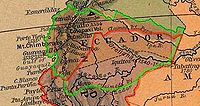
- Peru alleges that between 1910 and 1936 Ecuador took advantage of Peru's conflict with ChileChileChile ,officially the Republic of Chile , is a country in South America occupying a long, narrow coastal strip between the Andes mountains to the east and the Pacific Ocean to the west. It borders Peru to the north, Bolivia to the northeast, Argentina to the east, and the Drake Passage in the far...
and repeatedly made clandestine incursions into Peruvian territory. http://www.dlh.lahora.com.ec/paginas/debate/paginas/debate892.htm The 1924 agreement was intended to settle the dispute by arbitration.
- July 6, 1936: Ulloa-Viteri Accord
- This agreement established a status quoStatus quoStatu quo, a commonly used form of the original Latin "statu quo" – literally "the state in which" – is a Latin term meaning the current or existing state of affairs. To maintain the status quo is to keep the things the way they presently are...
border line based on the effective possession of territory that each country had in the Amazon region at the time. This border was very similar to that established by the Rio de Janeiro Protocol 5 years later. To Ecuador, the status quo line simply demonstrated how much territory Peru had taken from Ecuador in the preceding century. Ecuador never considered this agreement a final treaty of borders, and continued its aspirations which were based on Gual-Larrea and Pedemonte-Mosquera.
The Ecuadorian–Peruvian War
In 1941, the two countries went to war. As with all other such incidents, there are conflicting accounts to this day as to which side fired the first shot. Peru's version of events (notably well documented in Peruvian sources http://www.alasdegloria.com/Sec5p1.htmhttp://www.geocities.com/peruvictorsofcenepa/fap-1941.html) is that Ecuador had been making incursions into its territory since 1937 and occupied several border locations by 1940.Given these circumstances, the President of Peru, Manuel Prado Ugarteche
Manuel Prado Ugarteche
Manuel Prado y Ugarteche was a Peruvian banker and political figure. Son of former president, Mariano Ignacio Prado, he was born in Lima and served as the President of Peru twice, from 1939 until 1945 and again between 1956 and 1962...
, ordered the formation of the North Grouping, a military unit in charge of the Northern Operational Theater, on January 11, 1941, consisting of two light divisions with three battalions each, plus four other independent battalions and three artillery batteries (one with six 105 mm guns) (Delgado).
In front of these forces, the Ecuadorian Border Security command had under its orders two Army battalions, the "Montecristi" and the "Cayambe", each one consisting of around 250 troops, armed with 7,92 mm Mauser
Karabiner 98k
The Karabiner 98 Kurz was a bolt action rifle chambered for the 8x57mm IS/7.92×57mm IS cartridge that was adopted as the standard service rifle in 1935 by the German Wehrmacht. It was one of the final developments in the long line of Mauser military rifles...
rifles and a couple of Czech 7,92 mm ZB-26 light machine-guns, plus two Vickers-Maxim machine-guns. There was also a "Córdova" battalion, made up of around 100 troops, and a so-called "Mariscal Sucre" artillery battery, with 71 troops and no artillery pieces. In fact, the only artillery in the whole province of El Oro consisted of six Italian 65 mm mountain guns, sold to Ecuador as leftovers from the Great War, and almost without shells. These guns were never put into action. (Rodríguez, 1943).
As for anti-aircraft defenses, the Ecuadorians had only a pair of 20 mm Breda
Breda Model 35
The Cannone-Mitragliera da 20/65 modello 35 , also known as Breda Model 35, was a 20 mm anti-aircraft gun produced by the Società Italiana Ernesto Breda of Brescia company in Italy and used during World War II. It was designed in 1932 and was adopted by the Italian armed forces in 1935...
guns deployed on Puerto Bolivar, which was the only port of entry for supplies, reinforcements, and weapons to arrive to the province, by sea, from the port-city of Guayaquil. The Ecuadorian Army of 1941 had not a single warplane. (Rodríguez, 1943).
It is claimed that on Saturday, July 5, 1941 the Huaquillas
Huaquillas
Huaquillas is a town in western El Oro, a province of SW Ecuador. It is the canton seat of the Huaquillas Canton.Huaquillas is located on the border with Peru. An international bridge that goes over the Zarumilla River connects it with the Peruvian town of Aguas Verdes...
unit of the Ecuadorian army invaded Peruvian territory, an action which originated a combat that extended across the entire Zarumilla
Zarumilla
Zarumilla is a town in the Tumbes Region, in northwestern Peru. It has a population of 17,587 and is the capital of the Zarumilla Province...
front, up to a region known as Quebrada Seca.
Ecuador's version of events is that Peru's invasion was an unprovoked act of aggression carried out with the explicit purpose of forcing Ecuador to sign an unfavorable treaty that would impose the status quo border line.
A communiqué by Ecuador's Foreign Ministry indicated that Peruvian forces had been seen advancing north towards the border; all of the Peruvian troops stationed in Tumbes had left Zarumilla
Zarumilla
Zarumilla is a town in the Tumbes Region, in northwestern Peru. It has a population of 17,587 and is the capital of the Zarumilla Province...
and those in Piura
Piura
Piura is a city in northwestern Peru. It is the capital of the Piura Region and the Piura Province. The population is 377,496.It was here that Spanish Conqueror Francisco Pizarro founded the third Spanish city in South America and first in Peru, San Miguel de Piura, in July 1532...
and other nearby sites were in turn advancing towards Zarumilla
Zarumilla
Zarumilla is a town in the Tumbes Region, in northwestern Peru. It has a population of 17,587 and is the capital of the Zarumilla Province...
.
According to the Ministry, the actions of the Ecuadorian army were limited to repelling the invasion which was occurring across much of the border. http://www.alasdegloria.com/elcomercio/elc4.htm As support for its arguments Ecuador has repeatedly cited the obvious difference in military might between the two countries, and the lack of preparedness of its forces. It has been speculated that Peru prepared to carry out an all-out invasion and could have been simply waiting for the slightest provocation.
Ecuador has also cited Peru's history of conflict with its other neighbors as evidence of its belligerence. It has been pointed out, however, that these circumstances did not preclude Ecuador from attempting to lay claim to territories it still considered its own. Also, during the War of the Pacific
War of the Pacific
The War of the Pacific took place in western South America from 1879 through 1883. Chile fought against Bolivia and Peru. Despite cooperation among the three nations in the war against Spain, disputes soon arose over the mineral-rich Peruvian provinces of Tarapaca, Tacna, and Arica, and the...
, Ecuador military occupied a portion of the disputed territories.
The much larger and better equipped Peruvian force of 13,000 men quickly overwhelmed the 1,800 Ecuadorian troops guarding the province of El Oro
El Oro Province
El Oro province is the southernmost of Ecuador's coastal provinces. It was named for its historically important gold production. Today it is one of the world's major exporters of bananas. The capital is Machala.-Geography:To the north and east the province has borders with the provinces Guayas,...
. The Peruvian army had at its disposal a battalion of armor made up of Czech tanks LTP
Panzer 38(t)
The Panzerkampfwagen 38 was originally a Czech tank of pre-World War II design. After Czechoslovakia was taken over by Germany, it was adopted by the German Army, seeing service in the invasions of Poland and Russia. Production ended in 1942, when its armament was deemed inadequate. In all, over...
, with artillery and air support. (Beginning with the second third of the 20th century, Peru allegedly has one of the strongest military forces in South America
South America
South America is a continent situated in the Western Hemisphere, mostly in the Southern Hemisphere, with a relatively small portion in the Northern Hemisphere. The continent is also considered a subcontinent of the Americas. It is bordered on the west by the Pacific Ocean and on the north and east...
, even as recently as 2005 ranked second after Brazil
Brazil
Brazil , officially the Federative Republic of Brazil , is the largest country in South America. It is the world's fifth largest country, both by geographical area and by population with over 192 million people...
and stronger than Argentina
Argentina
Argentina , officially the Argentine Republic , is the second largest country in South America by land area, after Brazil. It is constituted as a federation of 23 provinces and an autonomous city, Buenos Aires...
http://americas.irc-online.org/am/165).
The Ecuadorian president, Carlos Arroyo del Río, kept Ecuador's best forces in Quito
Quito
San Francisco de Quito, most often called Quito , is the capital city of Ecuador in northwestern South America. It is located in north-central Ecuador in the Guayllabamba river basin, on the eastern slopes of Pichincha, an active stratovolcano in the Andes mountains...
, for fear of his political opponents (Arroyo would later resign on May 31, 1944 after much unrest in the country). Peru carried out the first use of paratroops in combat in the Western Hemisphere
Western Hemisphere
The Western Hemisphere or western hemisphere is mainly used as a geographical term for the half of the Earth that lies west of the Prime Meridian and east of the Antimeridian , the other half being called the Eastern Hemisphere.In this sense, the western hemisphere consists of the western portions...
, dropping three paratroopers over the port-city of Puerto Bolívar (Delgado), one of them having been rescued by Ecuadorian fishermen when he landed on the waters of the Jambelí channel.
This attempt was largely successful in allowing a relatively easy takeover of El Oro towns, devoid by then of any Ecuadorian military presence after the short-lived ceasefire of July 26, brokered by the mediator countries (USA, Brazil and Argentina). After the ceasefire, most of the Ecuadorian troops, by now exhausted and without ammunition, left the field of battle and made their way out of El Oro, towards the city of Cuenca
Cuenca, Ecuador
Cuenca is the capital of the Azuay Province. It is located in the highlands of Ecuador at about 2500 m above sea level...
.
Thus, when Peru reopened the advance on July 29, which began with simultaneous bombings on the Ecuadorian towns of Machala, Puerto Bolívar, Pasaje, Santa Rosa, and Arenillas, plus a mission to the city of Guayaquil to drop leaflets, the Peruvian forces easily occupied the deserted towns of the province. A new ceasefire having been decreed to enter in effect on July 31 at 18h00 forced the Peruvian command to step up its efforts to occupy Machala and Puerto Bolívar, which they did with troops disembarked directly on Puerto Bolívar from the sea in the afternoon of July 31. (Delgado)
Even then, hostilities didn't cease, as Peruvian forces began operations against the Ecuadorian posts on the Amazonian jungle, most of which were easily overrun.
With Peru occupying El Oro
El Oro Province
El Oro province is the southernmost of Ecuador's coastal provinces. It was named for its historically important gold production. Today it is one of the world's major exporters of bananas. The capital is Machala.-Geography:To the north and east the province has borders with the provinces Guayas,...
and menacing Guayaquil
Guayaquil
Guayaquil , officially Santiago de Guayaquil , is the largest and the most populous city in Ecuador,with about 2.3 million inhabitants in the city and nearly 3.1 million in the metropolitan area, as well as that nation's main port...
, plus pressure from the United States
United States
The United States of America is a federal constitutional republic comprising fifty states and a federal district...
and Latin America
Latin America
Latin America is a region of the Americas where Romance languages – particularly Spanish and Portuguese, and variably French – are primarily spoken. Latin America has an area of approximately 21,069,500 km² , almost 3.9% of the Earth's surface or 14.1% of its land surface area...
to stop the hostilities as a sign of hemispheric unity against the Axis powers
Axis Powers
The Axis powers , also known as the Axis alliance, Axis nations, Axis countries, or just the Axis, was an alignment of great powers during the mid-20th century that fought World War II against the Allies. It began in 1936 with treaties of friendship between Germany and Italy and between Germany and...
(in World War II
World War II
World War II, or the Second World War , was a global conflict lasting from 1939 to 1945, involving most of the world's nations—including all of the great powers—eventually forming two opposing military alliances: the Allies and the Axis...
), Peru and Ecuador signed the Rio de Janeiro
Rio de Janeiro
Rio de Janeiro , commonly referred to simply as Rio, is the capital city of the State of Rio de Janeiro, the second largest city of Brazil, and the third largest metropolitan area and agglomeration in South America, boasting approximately 6.3 million people within the city proper, making it the 6th...
Protocol.
Rio de Janeiro Protocol
Brazil
Brazil , officially the Federative Republic of Brazil , is the largest country in South America. It is the world's fifth largest country, both by geographical area and by population with over 192 million people...
, and Argentina
Argentina
Argentina , officially the Argentine Republic , is the second largest country in South America by land area, after Brazil. It is constituted as a federation of 23 provinces and an autonomous city, Buenos Aires...
offered their services in aiding in the mediation of the dispute. Their efforts failed to prevent the outbreak of hostilities on July 23, 1941, but the diplomatic intervention led to a definitive cease-fire being put into place on July 31. Despite this, limited skirmishes continued to occur through the months of August and September in the Ecuadorian provinces of El Oro
El Oro Province
El Oro province is the southernmost of Ecuador's coastal provinces. It was named for its historically important gold production. Today it is one of the world's major exporters of bananas. The capital is Machala.-Geography:To the north and east the province has borders with the provinces Guayas,...
and Loja
Loja Province
Loja Province is one of 24 provinces in Ecuador and shares its southern border on the west by El Oro Province, on the north by El Azuay, and on the east by Zamora-Chinchipe. Founded on its present site in 1548 by Captain Alonso de Mercadillo the site had been previously moved and rebuilt from La...
, as well as in the Amazonian lands. Ecuador accused Peru of continuing its advances into the highland province of Azuay
Azuay Province
Azuay is a province of Ecuador, created 25 June 1824. It encompasses an area of . Its capital is Cuenca. It is located in the south center of Ecuador in the highlands. Its mountains reach above sea level in the national park of El Cajas....
.
On October 2, with military observers from the three mediating countries serving as witnesses, Ecuador and Peru signed the Talara Accord, which created a demilitarized zone inside the provinces of El Oro and Loja, pending the signing of a definitive peace treaty. Diplomatic efforts continued, with the mediating countries being joined by Chile
Chile
Chile ,officially the Republic of Chile , is a country in South America occupying a long, narrow coastal strip between the Andes mountains to the east and the Pacific Ocean to the west. It borders Peru to the north, Bolivia to the northeast, Argentina to the east, and the Drake Passage in the far...
.
On January 29, 1942, on the final day of the third Pan-American Summit, held in Rio de Janeiro
Rio de Janeiro
Rio de Janeiro , commonly referred to simply as Rio, is the capital city of the State of Rio de Janeiro, the second largest city of Brazil, and the third largest metropolitan area and agglomeration in South America, boasting approximately 6.3 million people within the city proper, making it the 6th...
, the foreign ministers of Ecuador and Peru, Julio Tobar Donoso and Alfredo Solf y Muro
Alfredo Solf y Muro
Alfredo Solf y Muro was a Peruvian statesman. He was the Prime Minister of Peru from 8 December 1939 until 3 December 1944.- References :...
, signed a "Protocol of Peace, Friendship, and Boundaries", known as the Rio de Janeiro Protocol. The observers from the United States, Brazil, Argentina, and Chile co-signed the document, becoming "Guarantors of the Protocol". The Rio Protocol was subsequently ratified by each country's congress on February 26, 1942.
By the terms of the Protocol, Ecuador agreed to withdraw its long-standing claim for rights to direct land access to the Marañon
Marañón River
The Marañón River rises about 160 km to the northeast of Lima, Peru, flows through a deeply-eroded Andean valley in a northwesterly direction, along the eastern base of the Cordillera of the Andes, as far as 5 degrees 36' southern latitude; then it makes a great bend to the northeast, and...
and Amazon
Amazon River
The Amazon of South America is the second longest river in the world and by far the largest by waterflow with an average discharge greater than the next seven largest rivers combined...
rivers; Peru agreed to withdraw Peruvian military forces from Ecuadorian territory. An area of 200000 km² (77,220.4 sq mi) of hitherto disputed territory in the Maynas region of the Amazonian basin was awarded to Peru, which had been established to be the de facto
De facto
De facto is a Latin expression that means "concerning fact." In law, it often means "in practice but not necessarily ordained by law" or "in practice or actuality, but not officially established." It is commonly used in contrast to de jure when referring to matters of law, governance, or...
possessor of the land since the end of the 19th century. The "status quo" line defined in the 1936 Lima Accord was used as the basis for the definitive border line; the previous border recognized current possessions, but not sovereignty
Sovereignty
Sovereignty is the quality of having supreme, independent authority over a geographic area, such as a territory. It can be found in a power to rule and make law that rests on a political fact for which no purely legal explanation can be provided...
. Relative to the 1936 line, Ecuador ceded 18,552 km² of previously possessed territory to Peru, while Peru ceded 5,072 km² of previously possessed territory to Ecuador.
Ecuador's objections to the Protocol and thesis of Nullity
Six times during the demarcation technical problems were found and referred to the Guarantors, with BrazilBrazil
Brazil , officially the Federative Republic of Brazil , is the largest country in South America. It is the world's fifth largest country, both by geographical area and by population with over 192 million people...
acting as lead. One of them, which involved the then contested Cordillera del Cóndor, was submitted to arbitration by Captain Braz Dias de Aguiar. Both countries initially accepted the arbiter's award, issued July 1945, and demarcation began in the area according to that ruling.
During 1943 and 1946 the United States Air Force
United States Air Force
The United States Air Force is the aerial warfare service branch of the United States Armed Forces and one of the American uniformed services. Initially part of the United States Army, the USAF was formed as a separate branch of the military on September 18, 1947 under the National Security Act of...
performed several aerial reconnaissance missions over the Cordillera del Cóndor region (losing 2 aircraft and 14 men in accidents.) to help in the demarcation efforts. They found that the Cenepa river was much longer than previously thought and that it runs between the Zamora
Zamora River
The Zamora River is a tributary of the Santiago River located in the south-east of Ecuador. Historically, it was known to the Spanish as Yaya Mayu , from the river's name among a group of Shuar encountered nearby.The sources of the Zamora River are in the Podocarpus National Park, specifically at...
and the Santiago
Santiago River
Santiago River is a river of eastern Mexico. It flows through the municipality of Xalapa, in the state of Veracruz.-References:...
. This finding conflicted with article VIII, point B-1 of the Rio Protocol, which laid out delineation of the border for that area as follows:
- From the Quebrada de San Francisco, the watershed between the Zamora and Santiago Rivers, to the confluence of the Santiago River with the Yaupi;
The difficulty was that there is not one watershed between the Zamora and the Santiago, but two, as interpreted by Ecuador. This resulted in Ecuadorian president Galo Plaza
Galo Plaza
Galo Plaza Lasso was an Ecuadorian politician and statesman who served as the Ecuadorian Ambassador to the U.S, President of Ecuador from 1948 to 1952, and Secretary General of the Organization of American States from 1968 to 1975...
halting demarcation in 1949. About 78 kilometers of border were left unmarked. In 1953 Ecuador withdrew from the Demarcation Commissions, claiming the Protocol "impossible to implement" in that area.
On September 29, 1960 Ecuadorian president José María Velasco Ibarra
José María Velasco Ibarra
José María Velasco Ibarra was an Ecuadorian political figure. He served as the president of Ecuador from 1934–1935, 1944–1947, 1952–1956, 1960–1961, and 1968-1972. He only served one of those terms without being ousted by the army, from 1952-1956.-Early life and career:Velasco Ibarra was born on...
declared the Rio Protocol null and void. (Peruvian analysts have speculated that this was a politically motivated move by Velasco Ibarra, who was considered a populist, but evidence to support this assertion is totally circumstantial).
With the sole exception of Cuba
Cuba
The Republic of Cuba is an island nation in the Caribbean. The nation of Cuba consists of the main island of Cuba, the Isla de la Juventud, and several archipelagos. Havana is the largest city in Cuba and the country's capital. Santiago de Cuba is the second largest city...
, the American community did not approve of Ecuador's diplomatic move, with the United States sending a letter of protest to Ecuador.
The arguments for what is called Ecuador's thesis of nullity varied, but they were generally the following:
- It was imposed by military force.
- It was signed while Ecuadorian towns were under occupation; invasion and occupation of nation states are prohibited by international law.
- International law does not accept the conquest of territory by force or violence. Even considering de facto possession (1936 status quo border line) Peru took about 14,000 km² of territory.
- There was lack of compliance by Peru in denying Ecuador free navigation in Amazonian rivers as stipulated.
- It was a blow to the economic development of a South AmericaSouth AmericaSouth America is a continent situated in the Western Hemisphere, mostly in the Southern Hemisphere, with a relatively small portion in the Northern Hemisphere. The continent is also considered a subcontinent of the Americas. It is bordered on the west by the Pacific Ocean and on the north and east...
n country, which is contrary to existing pacts of cooperation.
Peru's counter-arguments included the following:
- Ecuador cannot unilaterally invalidate a protocol.
- The core argument on implementability is a demarcation issue, not a justification to invalidate the entire protocol.
- Peru disputes the notion that the protocol was imposed by premeditated military force.
- Even though the protocol was signed while Peruvian troops were still occupying El Oro for tactical reasons, the Ecuadorian congress ratified it long after Peruvian troops had left.
- Several Peruvian governments restricted the navigation clause in response to Ecuador's position on the treaty.
- On the issue of conquest of territory by force, Peru has pointed out that the disputed territories (Tumbes, Jaen and Maynas) were not under de jure Ecuadorian administration, and that the province of El Oro was not annexed to Peru.
Ecuador argued its thesis extensively for 30 years, but did not find support in the international community. Peru's position, on the other hand, was that a dispute did not exist at all after 1941, a position which lasted until 1995, when it was recognized as a problematic diplomatic issue.
Maps published in Ecuador since the 1960s up to the end of the 20th century officially had to exclude the unmarked 78 kilometers of border, that is, the Rio Protocol line was drawn as unresolved, and to include what Ecuador considered as its own by right, according to the Pedemonte-Mosquera protocol (1830) line, which puts the Marañon
Marañón
Marañón may refer to:* Marañón, Navarre, a town and municipality in Spain* Marañón River, in Peru* Marañón Province, in Peru* Valle del Marañón, a valley in Peru* Gregorio Marañón , Spanish physician, historian, writer and philosopher...
(Amazon
Amazon River
The Amazon of South America is the second longest river in the world and by far the largest by waterflow with an average discharge greater than the next seven largest rivers combined...
) river as the border between Peru and Ecuador.
Such controversial maps of Ecuador, known in Ecuador as "Tufiño's map", were referred in Peru as "mapa recortado del Peru" (cut-off map of Peru).
1995-1998: Arbitration and final resolution
A cease fire was brokered by the four guarantor countries, and subsequently the Itamaraty Peace Declaration was signed on February 17, 1995.One of the declaration's clauses included the creation the Military Observer Mission Ecuador-Peru (MOMEP) in order
to verify ceasefire agreements, observe and report infractions
through diplomatic channels.
The MOMEP contingent was made up
of observers, logistics, and aviation support from the United States
United States
The United States of America is a federal constitutional republic comprising fifty states and a federal district...
,
Argentina
Argentina
Argentina , officially the Argentine Republic , is the second largest country in South America by land area, after Brazil. It is constituted as a federation of 23 provinces and an autonomous city, Buenos Aires...
, Brazil
Brazil
Brazil , officially the Federative Republic of Brazil , is the largest country in South America. It is the world's fifth largest country, both by geographical area and by population with over 192 million people...
, and Chile
Chile
Chile ,officially the Republic of Chile , is a country in South America occupying a long, narrow coastal strip between the Andes mountains to the east and the Pacific Ocean to the west. It borders Peru to the north, Bolivia to the northeast, Argentina to the east, and the Drake Passage in the far...
as part of Operation Safe Border.
The mission, unique in its scope, was fully funded by Peru and Ecuador.
MOMEP was largely successful despite several tragic accidents due to
land mines left in the area.
At a critical moment during late July and early August 1998 it appeared that Peruvian forces were preparing a preemptive assault on Ecuadorian forces (this is partially believed due to the Peruvian airforce buying 19 Mig-29S and 18 Sukhoi-25 aircraft from Bielorussia to counter the abysmal state the airforce was at the beginning of the conflict, with 80% of the fleet grounded due to lack of spares), but the presence of the MOMEP contingent was instrumental in defusing the
situation. http://66.218.69.11/search/cache?p=ecuador+peru+1995+arbitration&toggle=1&ei=UTF-8&u=www.bu.edu/ihi/site_links/ihi_media_archive/downloads/peru.pdf&w=ecuador+peru+1995+arbitration&d=eV6CtGFULtkC&icp=1&.intl=us
The guarantors assisted the parties in ministerial level discussions aimed
at identifying the significant claims and disagreements of each side.
Both countries agreed to a guarantor-sponsored technical commission composed
of boundary experts in order to resolve the matter.
Before a critical meeting planned in Brazil for early 1997, both countries
entered a period of unforeseen political events. In Peru, there was a hostage
crisis in its Japanese embassy
Japanese embassy hostage crisis
The Japanese embassy hostage crisis began on 17 December 1996 in Lima, Peru, when 14 members of the Túpac Amaru Revolutionary Movement took hostage hundreds of high-level diplomats, government and military officials and business executives who were attending a party at the official residence of...
involving guerrillas of the Túpac Amaru Revolutionary Movement
Túpac Amaru Revolutionary Movement
The Túpac Amaru Revolutionary Movement was a Marxist revolutionary group active in Peru from the early 1980s to 1997 and one of the main actors in the internal conflict in Peru...
. Ecuador was going through a period of political instability as
President Abdala Bucaram
Abdalá Bucaram
Abdalá Jaime Bucaram Ortíz is an Ecuadorian politician and lawyer who briefly occupied the Presidency of Ecuador...
, a strong supporter of an agreement on the border
issue, was removed by congress due to alleged mental incapacity. (President Bucaram, who is known for his unusual antics, had visited Peru and was seen on TV eating ceviche
Ceviche
Ceviche is a seafood dish popular in the coastal regions of the Americas, especially Central and South America. The dish is typically made from fresh raw fish marinated in citrus juices such as lemon or lime and spiced with chilli peppers. Additional seasonings such as onion, salt,...
and wearing alpaca hoods—a traditional indigenous outfit—along with President Alberto Fujimori
Alberto Fujimori
Alberto Fujimori Fujimori served as President of Peru from 28 July 1990 to 17 November 2000. A controversial figure, Fujimori has been credited with the creation of Fujimorism, uprooting terrorism in Peru and restoring its macroeconomic stability, though his methods have drawn charges of...
.)
These delays nevertheless gave the guarantors more time to come up with
a solution to the dispute. Eventually they concluded that a resolution
would not be possible without granting something to each party.
The commission recognized Ecuador's position on one small already demarcated section of the border, and Peru's position on the larger issue of the single watershed between the
Zamora and Santiago rivers. The latter was a blow to Ecuador's historic position,
and left Tiwintza
Tiwintza Canton
Tiwintza Canton is a canton of Ecuador, located in the Morona-Santiago Province. Its seat is located in the town of Santiago....
in Peruvian territory.
The solution the commission arrived was that an area of one square kilometer at the site of
the fiercest fighting, Tiwintza, on the Peruvian side of the border,
be granted to Ecuador as a non-sovereign private property. The site
could be used by Ecuador to erect a monument and fly their flag.
Even though neither country was completely satisfied with the solution,
they both accepted it, which was a significant diplomatic success.
The resolution also called for the creation of two national parks
contiguous to one another (also referred to as a binational park)
in the Cordillera del Condor region.
Ambassador Luigi Einaudi, the US guarantor representative, is credited with coming
up with the idea of a private property concession in Tiwintza, working almost full time
on the problem, and coming up with ways to express issues in a manner not offensive
to either party. http://www.bu.edu/ihi/site_links/ihi_media_archive/downloads/peru.pdf#search='ecuador%20peru%201995%20arbitration'
On October 26, 1998, these two nations signed a comprehensive peace accord establishing the framework for ending a border dispute. Formal demarcation of border regions started on May 13, 1999. The agreement was ratified without opposition by both nations' congress. U.S. President Bill Clinton
Bill Clinton
William Jefferson "Bill" Clinton is an American politician who served as the 42nd President of the United States from 1993 to 2001. Inaugurated at age 46, he was the third-youngest president. He took office at the end of the Cold War, and was the first president of the baby boomer generation...
said: "This signing marks the end of the last and longest running source of armed international conflict in the Western hemisphere".
Political, social and economic impact
This dispute is unique and significant in the study of causes and resolution of international conflict. Ecuador and Peru are populated by people who share a language, a culture, a religious preference, have basically the same social and ethnic diversity, and comparable economic difficulties. They are also both democracies (for the most part in modern times) which puts in doubt the common contention that democracies never go to war with each other.Education and public perception
A 2000 study carried out as part of the educational ASA Program found teaching curriculum relating to the dispute to be extremely one-sided in both countries http://www.8ung.at/griesse/spanisch/themen/peru-ec/informe.pdf:- Notably, in Ecuador the dispute is a central issue in the study of Ecuador's borders. (Traditionally there has been a course named "History of Borders.")
- In Peru, the educational system does not give as much importance to the dispute with Ecuador, and is part of the course "Peruvian History". In contrast, the only topic related to the territorial dispute that is normally taught is the Rio Protocol, and its importance in the settlement of this dispute.
Many examples of bias are cited, which can typically be characterized as removal of critical information about the other side's position. Emotional and nationalistic coloring of the material also appears to be routine. Although expected under the circumstances, this has likely fed the cycle of conflict in the past.
Citizens of Ecuador and Peru feel both their countries have lost territory over time. The issue is one of overlapping maximalist territorial claims and aspirations.
Many Peruvians, for example, believe that their country is related with the Inca Empire
Inca Empire
The Inca Empire, or Inka Empire , was the largest empire in pre-Columbian America. The administrative, political and military center of the empire was located in Cusco in modern-day Peru. The Inca civilization arose from the highlands of Peru sometime in the early 13th century...
, and that compared to the Tahuantinsuyo, is relatively small. At one point, the Viceroyalty of Peru
Viceroyalty of Peru
Created in 1542, the Viceroyalty of Peru was a Spanish colonial administrative district that originally contained most of Spanish-ruled South America, governed from the capital of Lima...
contained most of South America. The Republic of Peru lost territorial claims to Bolivia
Bolivia
Bolivia officially known as Plurinational State of Bolivia , is a landlocked country in central South America. It is the poorest country in South America...
(formerly known as Upper Peru
Upper Peru
Upper Peru was the region in the Viceroyalty of Peru, and after 1776, the Viceroyalty of the Río de la Plata, comprising the governorships of Potosí, La Paz, Cochabamba, Los Chiquitos, Moxos and Charcas...
), Brazil
Brazil
Brazil , officially the Federative Republic of Brazil , is the largest country in South America. It is the world's fifth largest country, both by geographical area and by population with over 192 million people...
(Acre
Acre
The acre is a unit of area in a number of different systems, including the imperial and U.S. customary systems. The most commonly used acres today are the international acre and, in the United States, the survey acre. The most common use of the acre is to measure tracts of land.The acre is related...
and other Amazon territory), Colombia
Colombia
Colombia, officially the Republic of Colombia , is a unitary constitutional republic comprising thirty-two departments. The country is located in northwestern South America, bordered to the east by Venezuela and Brazil; to the south by Ecuador and Peru; to the north by the Caribbean Sea; to the...
(Leticia
Leticia
Leticia is a city in the Republic of Colombia, capital of the department of Amazonas, Colombia's southernmost town and the only major port on the Amazon river. It has an elevation of 96 meters above sea level and an average temperature of 27 °C . Leticia has long been Colombia's shipping point...
province) and Chile
Chile
Chile ,officially the Republic of Chile , is a country in South America occupying a long, narrow coastal strip between the Andes mountains to the east and the Pacific Ocean to the west. It borders Peru to the north, Bolivia to the northeast, Argentina to the east, and the Drake Passage in the far...
(Arica province and Tarapaca). Ecuadorians see their country as a continuation of what was the Real Audiencia de Quito, containing territories that are now parts of Peru and Colombia, reaching Brazil to the east.
High Peruvian military spending is seen by Ecuador as evidence of belligerence and expansionism. Peru also considers Ecuador belligerent and expansionist.
At the end of the 20th century things appear to have improved considerably. Ecuador's partial military success in the Cenepa War
Cenepa War
The Cenepa War , also known as the Alto Cenepa War, was a brief and localized military conflict between Ecuador and Peru, fought over control of a disputed area on the border between the two countries...
of 1995 allowed an honorable resolution of the conflict without a clear winner. To many Ecuadorians this was viewed as restoring the honor of the country, which was at least as important as their claims to the disputed territory. Unfortunately, not everyone is completely satisfied.
One example of this is the fact that in Peru there are still some who believe Ecuador shouldn't have been given perpetual private property rights over the single km² spot of land known as Tiwintza
Tiwintza Canton
Tiwintza Canton is a canton of Ecuador, located in the Morona-Santiago Province. Its seat is located in the town of Santiago....
, which saw some of the most fierce fighting during the war of 1995. In time, more progressive views have found their way in the public discourse. More significantly perhaps, by the 1990s both nations had become exhausted by the endless dispute, and were more interested in finding a definitive negotiated solution to the border problem than ever before.
Today, the entire Ecuadorian-Peruvian border is clearly delimited and demarcated, and the maps of both countries agree on the location of the common frontier. Bilateral work is being done by both countries Foreign Affairs officers to consolidate the economic and social integration. We can see part of this done by the Peruvian government with their Consulate in Machala, El Oro, where Minister Efrain Saavedra
Efrain Saavedra
Efrain Saavedra Barrera is a Peruvian diplomat who has served for the Peruvian Diplomatic office since 1972 in Rome, Italy; Vatican City, The Vatican; Tegucigalpa, Honduras; Valparaiso, Chile; Chicago, USA; Montevideo, Uruguay; Buenos Aires, Argentina and is currently assigned to Machala,...
is the Consul General.
Economic impact
One of the concerns both countries have had is the impact of the dispute on foreign investment. Thomas McLarty, US envoy at the resolution talks and former aid to President Bill ClintonBill Clinton
William Jefferson "Bill" Clinton is an American politician who served as the 42nd President of the United States from 1993 to 2001. Inaugurated at age 46, he was the third-youngest president. He took office at the end of the Cold War, and was the first president of the baby boomer generation...
, has said peace is essential to South America's economic recovery. He added: "You clearly cannot have long-term growth and prosperity involving foreign investment without stability". http://news.bbc.co.uk/2/hi/americas/201442.stm While there are still political instability issues in the region, resolution of the territorial conflict is helpful.
Trade between both countries has benefited considerably. Before signing the peace treaty, annual trade between Peru and Ecuador was about 100 million dollars. But as early as 1998, it had increased 5-fold. http://www.fujimorialberto.com/index.php?selection=artAll&articleId=1038
There was also a broad agreement of integration between both countries. http://www.opanal.org/Articles/Seminar-Lima/cabezas_lima_e.htm http://planbinacional.rree.gob.pe/domino/nsf/planbinacional.nsf/0/B773348FF71A8F9C05256F5D007779A0?OpenDocument It included a binational fund for peace and development, national plans for productive, social and environmental development, and so on.
Political implications
According to Gabriel Marcella (US Department of National Security and StrategyUnited States Department of Homeland Security
The United States Department of Homeland Security is a cabinet department of the United States federal government, created in response to the September 11 attacks, and with the primary responsibilities of protecting the territory of the United States and protectorates from and responding to...
), as
a result of the Ecuadorian-Peruvian territorial dispute "a number
of emerging views about international affairs, U.S. foreign policy, and modern
inter-American affairs were either shattered or seriously challenged". http://www.dtic.mil/doctrine/jel/research_pubs/amazon.pdf Some of the
global and regional political implications of the dispute which have been
noted are the following:
- It was a blow to the idea that democracies do not go to war with one another. An armed conflict between these two nations has existed well before then, nevertheless, on and off with major confrontations occurring in 1941, 1981 and 1995. Ecuador and Peru have both been full-fledged democracies for the most part in modern times, although of course not perfect or politically stable.
- It was a blow to the idea that Latin AmericaLatin AmericaLatin America is a region of the Americas where Romance languages – particularly Spanish and Portuguese, and variably French – are primarily spoken. Latin America has an area of approximately 21,069,500 km² , almost 3.9% of the Earth's surface or 14.1% of its land surface area...
is a model for peaceful international relations. It is a reminder that there are other territorial disputes and conflicting claims among other Latin American countries which could potentially threaten peace in the region.
- Civil-military relations in both countries have been impacted and need to be reexamined. If in fact the conflict was allowed to escalate after accidental encounters between patrols, it has been suggested that the civilian authority should perhaps assume more solid leadership and control.
- The principle that territorial treaties in Latin AmericaLatin AmericaLatin America is a region of the Americas where Romance languages – particularly Spanish and Portuguese, and variably French – are primarily spoken. Latin America has an area of approximately 21,069,500 km² , almost 3.9% of the Earth's surface or 14.1% of its land surface area...
are not the result of force or violence needs to be reexamined as a result.
Further reading
- Zook, David H., Jr. Zarumilla-Marañón: The Ecuador-Peru Dispute. New York: Bookman Associates, 1964.
- Marcella, Grabriel. Downes, Richard. Security Cooperation in the Western Hemisphere: Resolving the Ecuador-Peru Conflict. University of Miami Iberian Studies Institute, 1999.
- Lyman, Eric J., "War of the Map: The territorial dispute between Peru and Ecuador has its roots in the Inca Empire", Mercator's World Magazine, 2000.
- Peirce, Holly. Security cooperation in the western hemisphere: Lessons from the 1995 Ecuador-Peru conflict (North-South Center conference reports). North-South Center at the University of Miami, 1997.
- Delgado, Luis Humberto. Las Guerras del Perú. Tomo I. Lima, 1971.
- Rodríguez, Luis. La Agresión Peruana de 1941. Quito, 1943.
- Herz, Monica and Nogueira, João. Ecuador vs. Peru: Peacemaking amid Rivalry. Boulder: Lynne Rienner Publishers, 2002.
See also
- EcuadorEcuadorEcuador , officially the Republic of Ecuador is a representative democratic republic in South America, bordered by Colombia on the north, Peru on the east and south, and by the Pacific Ocean to the west. It is one of only two countries in South America, along with Chile, that do not have a border...
- PeruPeruPeru , officially the Republic of Peru , is a country in western South America. It is bordered on the north by Ecuador and Colombia, on the east by Brazil, on the southeast by Bolivia, on the south by Chile, and on the west by the Pacific Ocean....
- Dispute resolutionDispute resolutionDispute resolution is the process of resolving disputes between parties.-Methods:Methods of dispute resolution include:* lawsuits * arbitration* collaborative law* mediation* conciliation* many types of negotiation* facilitation...
- Territorial disputeTerritorial disputeA territorial dispute is a disagreement over the possession/control of land between two or more states or over the possession or control of land by a new state and occupying power after it has conquered the land from a former state no longer currently recognized by the new state.-Context and...
- Ecuadorian-Peruvian WarEcuadorian-Peruvian warThe Ecuadorian–Peruvian War was a border war fought between July 5, 1941 and July 31, 1941, the first of three military conflicts that occurred between these two South American nations during the 20th century....
- Paquisha Incident
- Cenepa WarCenepa WarThe Cenepa War , also known as the Alto Cenepa War, was a brief and localized military conflict between Ecuador and Peru, fought over control of a disputed area on the border between the two countries...
- General Richelieu LevoyerRichelieu LevoyerLevoyer Artieda, Richelieu. Military and politician of the Republic of Ecuador . Son of the Ecuadorian painter Jorge Levoyer and educator Maria Delia Artieda....