
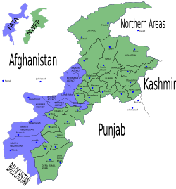
North-West Frontier Province
Encyclopedia
Khyber Pakhtunkhwa formerly known as the North-West Frontier Province and various other names, is one of the four provinces of Pakistan, located in the north-west of the country. It borders Afghanistan
to the north-west, Gilgit-Baltistan to the north-east, Azad Kashmir
to the east, the Federally Administered Tribal Areas
(FATA) to the west and south, Balochistan to the south and Punjab
and the Islamabad Capital Territory
to the south-east.
The main ethnic group in the province is the Pashtuns
; other smaller ethnic groups include most notably the Hazarewal
s and Chitralis. The principal languages are Pashto
, locally referred to as Pukhto.
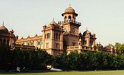
The provincial capital is Peshawar
, locally referred to as Pekhawar.
and comprises the junction where the slopes of the Hindu Kush
mountains on the Eurasian plate
give way to the Indus-watered hills approaching South Asia
. This situation has led to seismic activity in the past.
The famous Khyber Pass
links the province to Afghanistan, while the Kohalla Bridge in Circle Bakote Abbottabad is a major crossing point over the Jhelum River
in the east.
The province has an area of 28,773 mi² or (74,521 km²) - comparable in size to New England
in North America.
The province's main districts are Peshawar
, Mardan
, Dera Ismail Khan
, Lakki Marwat
, Kohistan, Kohat
, Abbottabad
, Haripur
and Mansehra
, Swat, Bannu
and Karak
. Peshawar
, Mardan
, Kohat
, Abbottabad
and Dera Ismail Khan
are the main cities.
The region varies in topography from dry rocky areas in the south to forests and green plains in the north. The climate can be extreme with intensely hot summers to freezing cold winters. Despite these extremes in weather, agriculture remains important and viable in the area.
The hilly terrain of Kalam
, Upper Dir, Naran
and Kaghan
is renowned for its beauty and attracts a great many tourists from neighboring regions and from around the world. Swat is termed 'a piece of Switzerland
' as there are many landscape similarities between it and the mountainous terrain of Switzerland.
According to the 1998 census, the population of the province was approximately 17 million. of whom 52% are males and 48% are females. The density of population is 187 per km² and the intercensal change of population is of about 30%. Geographically the province could be divided into two zones: the northern one extending from the ranges of the Hindu Kush
to the borders of Peshawar basin, and the southern one extending from Peshawar to the Derajat basin.
The northern zone is cold and snowy in winters with heavy rainfall and pleasant summers with the exception of Peshawar basin, which is hot in summer and cold in winter. It has moderate rainfall. The southern zone is arid with hot summers and relatively cold winters and scanty rainfall.
The major rivers that criss-cross the province are Kabul River, Swat River, Chitral River, Kunar River, Siran River, Panjgora River, Bara River, Kurram River, Dor River, Haroo River, Gomal River and Zhob River.
Its snow-capped peaks and lush green valleys of unusual beauty have enormous potential for tourism .
of Khyber Pakhtunkhwa varies immensely for a region of its size, encompassing most of the many climate types found in Pakistan. The province stretching southwards from the Baroghil Pass in the Hindu Kush
covers almost six degrees of latitude; it is mainly a mountainous region. Dera Ismail Khan is one of the hottest places in the South Asia while in the mountains to the north the weather is temperate in the summer and intensely cold in the winter. The air is generally very dry and consequently the daily and annual range of temperature is quite large.
Rainfall also varies widely. Although large parts of Khyber Pakhtunkhwa are typically dry, the province also contains the wettest parts of Pakistan in its eastern fringe.
Three main climatic regions can be distinguished within Khyber Pakhtunkhwa:
lies completely sheltered from the monsoon
that controls the weather in eastern Pakistan, owing to its relatively westerly location and the shielding effect of the Nanga Parbat
massif. In many ways Chitral District has more in common regarding climate with Central Asia
than South Asia. The winters are generally cold even in the valleys, and heavy snow
during the winter blocks passes and isolates the region from the world. In the valleys, however, summers can be hotter than on the windward side of the mountains due to lower cloud cover: Chitral can reach 40 °C (104 °F) frequently during this period. However, the humidity is extremely low during these hot spells and as a result the summer climate is less torrid than in the rest of the Indian subcontinent.
Most precipitation falls as thunderstorms or snow during winter and spring, so that the climate at the lowest elevations is classed as
Mediterranean
(Csa), continental Mediterranean (Dsa) or semi-arid (BSk). Summers are extremely dry in the north of Chitral district and receive only a little rain in the south around Drosh
. However, at elevations above 5000 metres (16,404.2 ft), it is known that as much as a third of the snow which feeds the large Karakoram and Hindukush glacier
s comes from the monsoon since these elevations are too high to be shielded from its moisture.
and in Upper
and Lower Dir District
s, rainfall is much heavier than further north because moist winds from the Arabian Sea
are able to penetrate the region and when they collide with the mountain slopes winter depressions provide heavy precipitation. The monsoon
, although short, is generally powerful and as a result the southern slopes of Khyber Pakhtunkhwa are the wettest part of Pakistan. Annual rainfall ranges from around 500 millimetres (19.7 in) in the most sheltered areas to as much as 1750 millimetres (68.9 in) in parts of Abbottabad and Mansehra Districts.
This region’s climate is classed at lower elevations as humid subtropical
(Cfa in the west; Cwa in the east); whilst at higher elevations with a southerly aspect it becomes classed as humid continental
(Dfb). However, accurate data for altitudes above 2000 metres (6,561.7 ft) are practically nonexistent either here, in Chitral, or in the south of the province.
The seasonality of rainfall in central Khyber Pakhtunkhwa shows very marked gradients from east to west. At Dir, March remains the wettest month due to frequent frontal cloud-bands, whereas in Hazara more than half the rainfall comes from the monsoon. This creates a unique situation characterized by a bimodal rainfall regime, which extends into the southern part of the province described below.
Since cold air from the Siberian High
loses its chilling capacity upon crossing the vast Karakoram and Himalaya ranges, winters in central Khyber Pakhtunkhwa are somewhat milder than in Chitral. Snow
remains very frequent at high altitudes but rarely lasts long on the ground in the major towns and agricultural valleys. Outside of winter, temperatures in central Khyber Pakhtunkhwa are not so hot as in Chitral, but significantly higher humidity when the monsoon is active means that heat discomfort can be greater. However, even during the most humid periods the high altitudes typically allow for some relief from the heat overnight.
, Balochistan and southern Punjab. As in central Khyber Pakhtunkhwa, the seasonality of precipitation shows a very sharp gradient from west to east, but the whole region very rarely receives significant monsoonal rainfall. Even at high elevations annual rainfall is less than 400 millimetres (16 in) and in some places as little as 200 millimetres (8 in).
Temperatures in southern Khyber Pakhtunkhwa are extremely hot: Dera Ismail Khan in the southernmost district of the province is known as one of the hottest places in the world with temperatures known to have reached 50 °C (122 °F). In the cooler months, however, nights can be cold and frosts remain frequent, though snow is very rare and daytime temperatures remain comfortably warm with abundant sunshine.
The province has an estimated population of about 21 million. The largest ethnic group is the Pashtun
, historically known as ethnic Afghans, who form well over two-thirds of the population. Around 1.5 Afghan refugees
also remain in the province, majority of which are Pashtuns followed by Tajiks, Hazaras, and other smaller groups. Despite having lived in the province for over two decades, they are registered as citizens of Afghanistan
.
Pashto
is the most pervasive language while Hindko is the second most commonly spoken indigenous language. It is predominant in eastern parts of Khyber Pakhtunkhwa and is the main language in most cities and towns including Peshawar.
Hindko is mostly spoken in eastern parts of Khyber Pakhtunkhwa, the Hazara Division
, and especially in the cities of Abbottabad
, Mansehra
, and Haripur, and also as a minority in the city of Peshawar. This language is spoken by the Hindkowan
who are an indian ethnic group.some afghan tribes also speak hindko as a first language. The provincial government is planning to introduce Hindko-medium education in Peshawar, Nowshera, Kohat, Haripur, Abbottabad and Mansehra districts.
In most rural areas of the centre and south various Pashtun tribes can be found including the Yusufzai
, Bhittani
, Daavi, Khattak
, Babar
, Gandapur
, Gharghasht, Marwat
, Afridi, Tanoli
, Shinwari, Orakzai
, Bangash
, Mahsud
, Mohmand
, and Wazir
as well as numerous other pushtun tribes of Hazara
division •, Swati
, Kakar
, Tareen
, Jadoon
and Mashwani. There are various non-Pashtun tribes including Mughal
, Turks, Gujjar
,Gujjar are also main tribe of Khaber pukhtoonkhwa,majority of the gujjar tribe has been further divede into different su-clan they speak pushtoo and write their cast afghan because some of them migrated from afghanistan and settled across the province, pukthoon concider these people as non pukhtoon tribe.Gujjar in afghanistan count 35 percent of the total population majority of them speak pushtoo and other languages.In pakistan punjab,sindh karachi,kashmir they are main ethnic group and Enjoing high positions in governament. in India gujjar are have high ranking tribes and ethnic group of baharath,they follow muslim relgion, hidusim and sikism. Karlal
, Rajpoot, Dhund Abbasi, Syed
, Kashmiri
, Awan
, Qureshi and Sarrara
.Kaka khels, Akhund Khel Akhund is the title given to any chief of special sanctity, Many Akhund Khels are Yousafzai Many Akhunkhels are Syeds. The Syed Akhunkhel Mians, enjoy special respect amongst the peoples on account of their ancestry. These individuals were religious people who traveled many years back and the Pukhtons welcomed and honored them. Visits to shrines or ziarats were very common especially by the women. Syed (Akhunkhel) is a respectable family of Khyber Pukhtoonkhwa who are known for their religious background. The mountainous extreme north includes the Chitral
and Kohistan
districts that are home to diverse Dardic ethnic groups such as the Khowar, Kohistani, Shina
, Torwali, Kalasha and Kalami.
However in the southern-most district live some of the Baloch tribe: Kori
, Buzdar, Kunara
, Leghari
, Rind
and some other sub tribes of Lashari tribe. These Baloch tribes speak Saraiki
as their first language. In this southern district, most of its population speaks Saraiki.
Nearly all of the inhabitants of the Khyber Pakhtunkhwa profess Islam
, with a Sunni majority and significant minorities of Shias and Ismaili
s. Many of the Kalasha of Southern Chitral still retain their ancient Animist/Shamanist religion.
, Scythians, Kushans, Huns
, Arabs, Turks
, Mongols
, Mughals
, and the British
. Between 2000 and 1500 BC, the Aryans split off into an Iranian branch
, represented by the Pushtuns who came to dominate most of the region, an Indo-Aryan branch represented by the Hindkowans
who populated much of the region before the time of the Pashtuns and various Dardic
peoples who came to populate much of the north. Earlier pre-Aryan inhabitants include the Shin or shinwaris and Burusho.
The region is mentioned in the Mahabharatha epic as Gandhara Kingdom
and lied in the outer fringes of Bharatvarsha.
The Vale of Peshawar was home to the Kingdom of Gandhara
probably from around the 6th century BC. It was known for its Hindu
and Buddhist heritage. It was part of Nanda
, Mauryan and Sunga empire before being overrun by foreigners. Ancient Peshawar
then known as Purushupura became a capital of the Kushan Empire
. The region was visited by such notable historical figures as Darius II
, Hsuan Tsang, Fa Hsien, Marco Polo
, and Mountstuart Elphinstone
, among others.
Following the Mauryan conquest of the region, Buddhism
became a major faith, at least in urban centres, as attested by recent archaeological and hermeneutic evidence. Kanishka
, a prominent Kushan ruler was one of the prominent Buddhist kings.
Rural areas retained numerous Shamanistic faiths as evident with the Kalash and other groups. The roots of Pashtunwali
or the traditional code of honor followed by the Pashtuns is also believed to have Pre-Islamic
origins. Persian invasions left small pockets of Zoroastrians and, later, a ruling Hindu
elite established itself during the later Shahi
period.
, prior to the arrival of Muslims
, Khyber Pakhtunkhwa region was ruled by the Shahi kings. The early Shahis were Buddhist rulers and reigned over the area until 870 CE when they were overthrown and then later replaced.
When the Chinese monk Xuanzang
visited the region early in the 7th century CE, the Kabul valley region was still ruled by affiliates of the Shahi kings, who is identified as the Shahi Khingal, and whose name has been found in an inscription found in Gardez.
While the early Shahis were Turko-Iranian
and Kabulistan
i in origin referred as Kushano-Hepthalites, the later Shahi kings of Kabul and Gandhara were Hindu
and had links to some ruling families in neighbouring Kashmir and the Punjab. The Hindu Shahis are believed to have been a ruling elite of a predominantly Buddhist, Hindu and Shamanistic population and were thus patrons of numerous faiths, and various artefacts and coins from their rule have been found that display their multicultural domain.
The last Shahi rulers were eventually wiped out by Mahmud of Ghazni
in the early 11th century AD.
, Zoroastrianism
, Buddhism
and Shamanism
were the prominent in the region until Muslim Arabs
and Turks
conquered the area before the 2nd millennium CE. Over the centuries some migrations took place by the local population consisting majorly of Hindus and Buddhists while the remaining converted to Islam
. Local Pashtun and Dardic tribes converted to Islam, while retaining some local traditions (albeit altered by Islam) such as Pashtunwali
or the Pashtun code of honor.
(975-1187), headed by Sultan Mahmud of Ghazni
, and the empire of Muhammad Shahabuddin Ghauri (reigned 1202–1206). The Ghaznavid domain included Afghanistan extending up to Punjab and parts of the Indian subcontinent, with its capital at Lahore
from 1151 to 1186.
Later the Afghan Pashtun Muslims of the Delhi Sultanate
controlled the region. (The "Delhi Sultanate" refers to the many Muslim
states that ruled in India
from 1206 to 1526.)
Several Turkic
and Afghan
dynasties ruled from Delhi instead of from Lahore: the Mamluk dynasty (1206–90), the Khilji dynasty
(1290–1320), the Tughlaq dynasty
(1320–1413), the Sayyid dynasty
(1414–51), and the Lodi dynasty (1451–1526).
and the Ilkhanate
Empire of the Turks, coming from Great Timur Lang and his grandsons like Babur
the Mughal Dynasty.
Muslim technocrats, bureaucrats, soldiers, traders, scientists, architects, teachers, theologians and sufis flocked from the rest of the Muslim world to the region and Islam flourished because of these Northern Afghan and Central Asian invaders.
founded by Ahmad Shah Durrani
in 1747. Ahmed Shah Durrani was born in Kabul
which was at that time part of Afghanistan
. The empire included Bahwalpur, Kashmir
, Gilgit
, Hazara with its main city Haripur. Under Ahmed Shah Durrani and later his son Timur Shah, who ruled from Lahore and Multan, but later shifted it back to Kandahar
.
Khyber Pakhtunkhwa was an important iranian
borderland that was often contested by the Mughals and Safavids who considered it part of their land. During the reign of the Mughal emperor Aurangzeb
, Khyber Pakhtunkhwa required formidable military forces to control and the emergence of Pashtun
nationalism, who opposed Mughals who were trying to infiltrate it from India across the Indus River
. A leading force in inspiring Pashtun miltancy was the local warrier poet Khushal Khan Khattak
who united some of the tribes against the various empires around the region.
As the Mughal had lost control by 1757, Khyber Pakhtunkhwa came under the control of the Amir of Afghanistan Ahmad Shah Abdali.
The Afghans governed Hazara-i-Karlugh
, Gandhgarh and the Gakhar
territory from Attock
; while Kashmir
collected the revenue from the upper regions of Pakhli
, Damtaur and Darband. In 1813, the Sikhs conquered the fort of Attock, at which time lower Hazara became tributary to them. Upper Hazara shared the same fate in 1819, when the Sikhs conquered Kashmir. The territory referred to as Hazara formed when Maharaja Ranjit Singh
bestowed the area as a jagir on Hari Singh Nalwa
, Commander-in-Chief of the Sikh army, in 1822.
The Sikhs forayed into Peshawar
for the first time in 1818, but did not occupy the territory. In 1823, following the Battle of Naushehra on the banks of the Kabul river
, Hari Singh Nalwa and his men chased the Afghans first to Peshawar and then to the mouth of the Khyber Pass
. The Sikhs entered the city of Peshawar for a second time, once again affirming to hold Peshawar as a tributary to the Sikh Court of Lahore
. After plundering the city they burnt its fortress, the Bala Hissar
.
The Sikh occupation of Peshawar in 1834, was executed in a most unusual manner. By 1836, with the conquest of Jamrud
the frontier of the Sikh Kingdom bordered the foothills of the Hindu Kush Mountains and the Khyber Pass formed its western boundary. However the death of sikh general Hari Singh Nalwa
at Battle of Jamrud spelt a blow to Sikh forward advance policy and their wish to conquer Kabul. The death of King Ranjit Singh
in 1839 plunged the Sikh kingdom into turmoil and after the loss in 2 Anglo-Sikh wars, British took direct control of the region.
The most significant contributions of Sikh rule to this region were the city of Haripur, the first planned city in this entire region, and the forts of Sumergarh (Bala Hissar, Peshawar) and Fatehgarh
(Fort of Jamrud at the mouth of the Khyber Pass).
 The British, who had captured most of the subcontinent without significant problems, faced a number of difficulties here. However, crossing the Indus River
on to the Iranian plateau
and Pushtun territory which lay there gave them a new type of challenge. The Pashtuns, strong in their belief that they must defend their land from foreign incursion, resisted the British advancement. The first war between British and the Pashtuns
resulted in a devastating defeat for the British, with just one individual, Dr. William Brydon
coming back alive (out of a total of 14,800-21,000 people). This happened during the First Anglo-Afghan War
of 1849 and later the Second Anglo-Afghan War
of 1876. The Third Anglo-Afghan War
of 1919, was also a continuation of the fight for Reclaiming Areas of Khyber Pakhtunkhwa and claiming independence from British occupation efforts which the Afghans
or the Pashtuns resisted with greatest zeal and effort to remain as independent nation.
Unable to enforce their rule and invade these territories fully in the region, the British changed their tactics and played a game of divide and rule
. They exploited religious differences, installed puppet Pushtun rulers, divided the Pashtuns through artificially-created regions, and ruled indirectly to reduce the chance of confrontation between Pashtuns and themselves. Although the smallest size province Pushtoons were divided into Provincially Administered Tribal Areas
(PATA), Federally Administered Tribal Areas
(FATA), Frontier Regions
(FR) and Settled Areas of Khyber Pakhtunkhwa and Baluchistan
. Khyber Pakhtunkhwa was restricted to five districts.
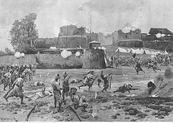
Occasional Pushtun resistance and attacks did take place on British in Khyber Pakhtunkhwa, including the Siege of Malakand
and Swat, both well documented by Winston Churchill
who was a war correspondent at the time.
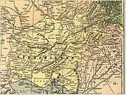
A series of conflicts known as the Anglo-Afghan Wars during the imperialist Great Game
, wars between the British and Russia
n governments, led to the eventual dismemberment of Afghanistan into Khyber Pakhtunkhwa, Baluchistan
and Khurasan
. Divide and rule policy and the annexation of Khyber Pakhtunkhwa and Baluchistan region led to the demarcation of the Durand Line and administration as part of British India.
The Durand line is a poorly marked 1519 miles (2,445 km) border between Afghanistan and Pakistan. After fighting in two wars against Afghans, the British succeeded in 1893 in imposing the Durand line, dividing Afghanistan from Khyber Pakhtunkhwa, Baluchistan, FR regions, FATA which were incorporated into what was then British India
. It was agreed upon by representatives of both governments.
The international boundary line separating two countries was named after Sir Mortimer Durand
, foreign secretary of the British colonial government, who in 1893 had negotiated with Abdur Rahman Khan
, the Amir of Afghanistan, on the frontier between modern-day Afghanistan and Pakistan.
Areas annexed from Afghanistan were the FATA, Khyber Pakhtunkhwa and Balochistan provinces of Pakistan, the successor state of British India and the successor Iran
ian state of Khorasan
.
In 1893, Sir Mortimer Durand was sent to Kabul by the government of British India for the purpose of settling an exchange of territory required by the demarcation of the boundary between northeastern Afghanistan, Iran and the Russian possessions.
The Amir showed ability in diplomatic argument, his tenacity where his own views or claims were in debate, with a sure underlying insight into the real situation. The territorial exchanges were amicably agreed upon; the relations between the British Indian and Afghan governments, as previously arranged, were confirmed; and an understanding was reached upon the important and difficult subject of the border line of Afghanistan on the east, towards India.
From the British side the camp was attended by Sir Mortimer Durand and Sahibzada Abdul Qayyum the, Political Agent
for the Khyber Agency
. Afghanistan was represented by Sahibzada Abdul Latif
and the Governor Sardar Shireendil Khan
representing the King Amir Abdur Rahman Khan.
While the Afghan side greatly resented the border and viewed it as a temporary development, the British viewed it as being a permanent settlement. The North-West Frontier Province was formed on November 9, 1901, as a Chief Commissioner
ruled province, the Chief Commissioner was the chief executive of the province.
He ran the administration with the help of his principal advisers and Civil servants better known as judicial and Revenue Commissioners.
The formal inauguration of the province took place five and half months later, at Shahi Bagh on April 26, 1902, on the occasion of the historical Darbar in the Shahi Bagh (Kings Garden) in the capital town of Peshawar
.
It was held by Lord Curzon
the Governor of the North-West Frontier Province. The province then comprised only five districts after dividing annexed areas from Afghanistan into FATA, Frontier Regions and the North-West Frontier Province and Southern Punjab
.
North-West Frontier Province districts were Peshawar District
, Hazara District
, Kohat District
, Bannu District
and the Dera Ismail Khan District
.
The first Chief Commissioner of the North-West Frontier Province was Harold Deane
. He was known as a strong administrator and he was succeeded by Ross-Keppel
, in 1908, whose contribution as a political officer was widely known amongst the tribal/frontier people.
North-West Frontier Province was raised to a full-fledged governor-ruled province in 1931 in accordance with the demand by the Round Table Conference
held in 1931. It was agreed upon in the conference that the North-West Frontier Province would be raised to a governor-ruled province with its own Legislative Council
. Sir Ralph Griffith
was appointed the first Governor in 1932 (having succeeded Stuart Pearks
as Chief Commissioner in 1931).
Therefore, on January 25, 1932, the Viceroy
inaugurated the first North-West Frontier Province Legislative Council. The first provincial elections were held in 1937 and the independent candidate and noted British loyal civil servant Sahibzada Abdul Qayyum was elected as the province's first Chief Minister.
agitated through Non-violence for the rights of Pashtun areas.
Following independence, the North-West Frontier Province voted to join Pakistan
in a referendum in 1947. However, Afghanistan's loya jirga
of 1949 declared the Durand Line invalid, which led to border tensions with Pakistan. Afghanistan's governments have periodically refused to recognize Pakistan's inheritance of British treaties regarding the region, leading to a counter-claim by Pakistan that the original treaties, if they must be discussed, can only be held with the original signer, the Kingdom of Afghanistan, which is now defunct - essentially denying modern Afghanistan the same sort of inheritance rights that it denies Pakistan.
During the 1950s, Afghanistan supported the Pushtunistan Movement, a secessionist movement that failed to gain substantial support amongst the tribes of the North-West Frontier Province. Afghanistan's refusal to recognize the Durrand Line, and its subsequent support for the Pashtunistan Movement has been cited as the main cause of tensions between the two countries that have existed since Pakistan's independence.
After Ayub Khan eliminated Pakistan's provinces, Yahya Khan
, in 1969, abolished this "one unit" scheme and added Amb
, Swat, Dir, Chitral and Kohistan
to the new North-West Frontier Province as the Provincially Administered Tribal Areas
.
who fought the Soviets
during the 1980s.
Following the arrival of Soviet forces, over five million Afghan refugees poured into Pakistan, most residing in the North-West Frontier Province (as of 2007, nearly 3 million remained).
The North-West Frontier Province remained heavily influenced by events in Afghanistan. Civil war in Afghanistan (1989–1992) led to the rise of the Taliban, which had emerged in the border region between Afghanistan, Baluchistan, PATA and FATA as a formidable political force. Following the terrorist attacks of September 11, 2001, the FATA and bordering North-West Frontier Province became a front-line region again, as part of the global "War on Terror
".
In 2010 the name of the province changed to "Khyber Pakhtunkhwa". Protests arose among the local ethnic Hazara population due to this name change, as they began to demand their own province. Seven people were killed and 100 injured in protests on 11 April 2011.
 The Provincial Assembly of Khyber Pakhtunkhwa is unicameral and consists of 124 seats of which 2% are reserved for non-Muslims and 17% for women only.
The President of Pakistan appoints a Governor as head of the provincial government of Khyber Pakhtunkhwa. There is a directly-elected Provincial Assembly, which has 124 elected members (including 22 seats reserved for women and 3 seats for non-Muslims). The Provincial Assembly elects a Chief Minister to act as the chief executive of the province, assisted by a cabinet of ministers.
Khyber Pakhtunkhwa is divided into 25 districts, comprising 20 Settled Area Districts and 5 Provincially Administered Tribal Area
(PATA) Districts. The administration of the PATA districts is vested in the President of Pakistan and the Governor of Khyber Pakhtunkhwa, by Articles 246 and 247 of the Constitution of Pakistan.
TOR GHAR(kala dhaka)
 Khyber Pakhtunkhwa's share of Pakistan's GDP has historically comprised 10.5%, although the province accounts for 11.9% of Pakistan's total population, rendering it the second-poorest province after neighboring Balochistan
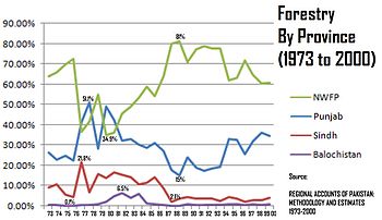
. The part of the economy that Khyber Pakhtunkhwa dominates is forestry, where its share has historically ranged from a low of 34.9% to a high of 81%, giving an average of 61.56%. Currently, Khyber Pakhtunkhwa accounts for 10% of Pakistan's GDP, 20% of Pakistan's mining output and since 1972, it has seen its economy grow in size by 3.6 times.
After suffering for decades due to the fallout of the Soviet invasion of Afghanistan, today they are again are being targeted for totally a different situation of terrorism.
Agriculture remains important and the main cash crops include wheat, maize, Tobacco (in Swabi), rice, sugar beets, as well as various fruits are grown in the province.
Some manufacturing and high tech investments in Peshawar has helped improve job prospects for many locals, while trade in the province involves nearly every product. The bazaars in the province are renowned throughout Pakistan. Unemployment has been reduced due to establishment of industrial zones.
Numerous workshops throughout the province support the manufacture of small arms and weapons of various types. The province accounts for at least 78% of the marble
production in Pakistan.
The Awami National Party
sought to rename the province "Pakhtunkhwa", which translates to "Land of Pakhtuns" in the Pashto language
. This was opposed by some of the non-Pashtuns, and especially by parties such as the Pakistan Muslim League-N (PML-N) and Muttahida Majlis-e-Amal
(MMA). The PML-N derives its support in the province from primarily non-Pashtun Hazara regions.
In 2010 the announcement that the province would have a new name led to a wave of protests in the Hazara region.
On April 15, 2010 Pakistan's senate
officially named the province "Khyber Pakhtunkhwa" - with 80 senators in favor and 12 opposed. The MMA, who until the elections of 2008 had a majority in the Khyber Pakhtunkhwa government, had proposed "Afghania" as a compromise name.
After the 2008 general election
, the Awami National Party formed a coalition provincial government with the Pakistan Peoples Party
. The Awami National Party has its strongholds in the Pashtun areas of Pakistan, particularly in the Peshawar
valley, while Karachi
in Sindh
has one of the largest Pashtun populations in the world - around 7 million by some estimates. In the 2008 election the ANP won two Sindh assembly seats in Karachi. The Awami National Party has been instrumental in fighting the Taliban.
Khowar folk music is popular in Chitral and northern Swat. The tunes of Khowar music are very different from those of Pashto and the main instrument is the Chitrali Sitar.
A form of band music composed of clarinets (surnai) and drums is popular in Chitral. It is played at polo matches and dances. The same form of band music is also played in the neighbouring Northern Areas
.
), which is located in Topi, a town in Swabi district. The University of Peshawar
is also a notable institution of higher learning. The Frontier Post
is perhaps the province's best-known newspaper and addresses many of the various issues facing the local population.
Sources:
This is a chart of the education market of Khyber Pakhtunkhwa estimated by the government in 1998. Also see
Afghanistan
Afghanistan , officially the Islamic Republic of Afghanistan, is a landlocked country located in the centre of Asia, forming South Asia, Central Asia and the Middle East. With a population of about 29 million, it has an area of , making it the 42nd most populous and 41st largest nation in the world...
to the north-west, Gilgit-Baltistan to the north-east, Azad Kashmir
Azad Kashmir
Azad Jammu and Kashmir or Azad Kashmir for short, is the southernmost political entity within the Pakistani-administered part of the former princely state of Jammu and Kashmir...
to the east, the Federally Administered Tribal Areas
Federally Administered Tribal Areas
The Federally Administered Tribal Areas are a semi-autonomous tribal region in the northwest of Pakistan, lying between the province of Khyber Pakhtunkhwa, Balochistan, and the neighboring country of Afghanistan. The FATA comprise seven Agencies and six FRs...
(FATA) to the west and south, Balochistan to the south and Punjab
Punjab (Pakistan)
Punjab is the most populous province of Pakistan, with approximately 45% of the country's total population. Forming most of the Punjab region, the province is bordered by Kashmir to the north-east, the Indian states of Punjab and Rajasthan to the east, the Pakistani province of Sindh to the...
and the Islamabad Capital Territory
Islamabad Capital Territory
The Islamabad Capital Territory is one of the two federal territories of Pakistan. It includes Islamabad, the capital city of Pakistan, and covers an area of 1,165.5 km² of which 906 km² is Islamabad proper...
to the south-east.
The main ethnic group in the province is the Pashtuns
Pashtun people
Pashtuns or Pathans , also known as ethnic Afghans , are an Eastern Iranic ethnic group with populations primarily between the Hindu Kush mountains in Afghanistan and the Indus River in Pakistan...
; other smaller ethnic groups include most notably the Hazarewal
Hazarewal
Hazarewal or Hazarawal is another name or term for the Hindkowan people, a Hindko speaking community who belong to the Hazara region of Khyber Pakhtunkhwa ,Pakistan. The Hazarewal/Hindkowan/s are not to be confused with the ethnic Hazara people inhabiting parts of Baluchistan province in Pakistan...
s and Chitralis. The principal languages are Pashto
Pashto language
Pashto , known as Afghani in Persian and Pathani in Punjabi , is the native language of the indigenous Pashtun people or Afghan people who are found primarily between an area south of the Amu Darya in Afghanistan and...
, locally referred to as Pukhto.
The provincial capital is Peshawar
Peshawar
Peshawar is the capital of Khyber-Pakhtunkhwa and the administrative center and central economic hub for the Federally Administered Tribal Areas of Pakistan....
, locally referred to as Pekhawar.
Geography
Khyber Pakhtunkhwa sits primarily on the Iranian plateauIranian plateau
The Iranian plateau, or Iranic plateau, is a geological formation in Southwest Asia. It is the part of the Eurasian Plate wedged between the Arabian and Indian plates, situated between the Zagros mountains to the west, the Caspian Sea and the Kopet Dag to the north, the Hormuz Strait and Persian...
and comprises the junction where the slopes of the Hindu Kush
Hindu Kush
The Hindu Kush is an mountain range that stretches between central Afghanistan and northern Pakistan. The highest point in the Hindu Kush is Tirich Mir in the Chitral region of Khyber-Pakhtunkhwa, Pakistan.It is the westernmost extension of the Pamir Mountains, the Karakoram Range, and is a...
mountains on the Eurasian plate
Eurasian Plate
The Eurasian Plate is a tectonic plate which includes most of the continent of Eurasia , with the notable exceptions of the Indian subcontinent, the Arabian subcontinent, and the area east of the Chersky Range in East Siberia...
give way to the Indus-watered hills approaching South Asia
South Asia
South Asia, also known as Southern Asia, is the southern region of the Asian continent, which comprises the sub-Himalayan countries and, for some authorities , also includes the adjoining countries to the west and the east...
. This situation has led to seismic activity in the past.
The famous Khyber Pass
Khyber Pass
The Khyber Pass, is a mountain pass linking Pakistan and Afghanistan.The Pass was an integral part of the ancient Silk Road. It is mentioned in the Bible as the "Pesh Habor," and it is one of the oldest known passes in the world....
links the province to Afghanistan, while the Kohalla Bridge in Circle Bakote Abbottabad is a major crossing point over the Jhelum River
Jhelum River
Jehlum River or Jhelum River , ) is a river that flows in India and Pakistan. It is the largest and most western of the five rivers of Punjab, and passes through Jhelum District...
in the east.
The province has an area of 28,773 mi² or (74,521 km²) - comparable in size to New England
New England
New England is a region in the northeastern corner of the United States consisting of the six states of Maine, New Hampshire, Vermont, Massachusetts, Rhode Island, and Connecticut...
in North America.
The province's main districts are Peshawar
Peshawar District
Peshawar is a district in the Khyber Pakhtunkhwa province of Pakistan. Until divisions were abolished as part of local government reforms in 2000 it was part of Peshawar Division. The city of Peshawar, as well as being the provincial capital, is the capital of the district...
, Mardan
Mardan District
Mardan is a district in the Khyber Pakhtunkhwa province of Pakistan. The city of Mardan is the headquarters of the district. The district also contains the famous archaeological site of Takht Bhai, Jamal Ghari and Sawal Dher.-Administration:...
, Dera Ismail Khan
Dera Ismail Khan District
Dera Ismail Khan is one of the 24 districts in the Khyber Pakhtunkhwa province of Pakistan. The capital of the district is the town of Dera Ismail Khan...
, Lakki Marwat
Lakki Marwat District
Lakki Marwat is one of the Southern Districts of Khyber Pakhtunkhwa in Pakistan. It was created as an administrative district on July 1, 1992, prior to which it was a Tehsil of Bannu District.-Etymology:...
, Kohistan, Kohat
Kohat District
Kohat is a district of the Khyber-Pakhtunkhwa province of Pakistan, Kohat city is the capital of the district. It is inhabited by various Pashtun tribes such as Afridi,Khattaks, Bangash and the Orakzaies. The main language of the district is Pashto....
, Abbottabad
Abbottabad District
Abbottabad is a district in the Khyber Pakhtunkhwa province of Pakistan. The district covers an area of 1,969 km with the city of Abbottabad being the principal town...
, Haripur
Haripur District
Haripur is a district in the Hazara region of Khyber-Pukhtunkhwa, province of Pakistan with an altitude of around above sea level. Haripur District has the highest Human Development Index of all the districts in the Hazara....
and Mansehra
Mansehra District
Mansehra District is in the Khyber Pakhtunkhwa province of Pakistan, an area still unofficially known as the Northwest Frontier. Mansehra district and town are named after Man Singh, a leading general of Mughal Emperor Akbar...
, Swat, Bannu
Bannu District
Bannu District is one of the twenty four districts of the Khyber Pakhtunkhwa province of Pakistan, it is represented in the provincial assembly by four MPAs. The chief city of the district is Bannu. The major industries are cloth weaving and the manufacture of cotton fabrics, machinery, and...
and Karak
Karak District
Karak is a district of the Khyber Pakhtunkhwa province of Pakistan. It is situated to the south of Kohat District and on the north side of Bannu and Lakki Marwat districts on the main Indus Highway between Peshawar and Karachi - it is 123 km from the provincial capital Peshawar...
. Peshawar
Peshawar
Peshawar is the capital of Khyber-Pakhtunkhwa and the administrative center and central economic hub for the Federally Administered Tribal Areas of Pakistan....
, Mardan
Mardan
Mardan , known as The city of hospitality, is a city and headquarters of Mardan District in Khyber Pakhtunkhwa Province, Pakistan. It is the de facto headquarters of the Yousafzai tribe and the second most populous city in the province, located at 34°12'0N 72°1'60E and an altitude of in the south...
, Kohat
Kohat
Kohat is a medium sized town in Khyber Pakhtunkhwa province of Pakistan. It is located at 33°35'13N 71°26'29E with an altitude of 489 metres and is the capital of Kohat District. The town centres around a British-era fort, various bazaars, and a military cantonment. A British-built narrow gauge...
, Abbottabad
Abbottabad
Abbottabad is a city located in the Hazara region of the Khyber Pakhtunkhwa province, in Pakistan. The city is situated in the Orash Valley, northeast of the capital Islamabad and east of Peshawar at an altitude of and is the capital of the Abbottabad District...
and Dera Ismail Khan
Dera Ismail Khan
Dera Ismail Khan is a city in Khyber-Pakhtunkhwa Province, Pakistan. It is situated on the west bank of the Indus River, west of Lahore and northwest of Multan. The city is the capital of the district and tehsil of the same name. In Pakistan, its name is often abbreviated to D. I...
are the main cities.
The region varies in topography from dry rocky areas in the south to forests and green plains in the north. The climate can be extreme with intensely hot summers to freezing cold winters. Despite these extremes in weather, agriculture remains important and viable in the area.
The hilly terrain of Kalam
Kalam valley
Kalam Valley is a valley along the upper reaches of the Swat River in Swat, in the Khyber Pakhtunkhwa province of Pakistan.Kalam Valley is known for its waterfalls, lakes and lush green hills, and is a 270 km drive from Islamabad, the capital of Pakistan...
, Upper Dir, Naran
Naran Valley
Naran Valley is located in Khyber-Pakhtunkhwa, Pakistan. The Kunhar River, swollen by glacier melt, meanders its way through the Naran Valley. Makra Peak, Malka Parbat, Lalazar and Saiful Muluk are the main attractions.- External links :****...
and Kaghan
Kaghan Valley
The Kaghan Valley is a valley in the north-east of Mansehra District of the Khyber Pakhtunkhwa Province of Pakistan. It attracts many tourists from around the world. The inhabitants were affected by the earthquake disaster on 8 October 2005....
is renowned for its beauty and attracts a great many tourists from neighboring regions and from around the world. Swat is termed 'a piece of Switzerland
Switzerland
Switzerland name of one of the Swiss cantons. ; ; ; or ), in its full name the Swiss Confederation , is a federal republic consisting of 26 cantons, with Bern as the seat of the federal authorities. The country is situated in Western Europe,Or Central Europe depending on the definition....
' as there are many landscape similarities between it and the mountainous terrain of Switzerland.
According to the 1998 census, the population of the province was approximately 17 million. of whom 52% are males and 48% are females. The density of population is 187 per km² and the intercensal change of population is of about 30%. Geographically the province could be divided into two zones: the northern one extending from the ranges of the Hindu Kush
Hindu Kush
The Hindu Kush is an mountain range that stretches between central Afghanistan and northern Pakistan. The highest point in the Hindu Kush is Tirich Mir in the Chitral region of Khyber-Pakhtunkhwa, Pakistan.It is the westernmost extension of the Pamir Mountains, the Karakoram Range, and is a...
to the borders of Peshawar basin, and the southern one extending from Peshawar to the Derajat basin.
The northern zone is cold and snowy in winters with heavy rainfall and pleasant summers with the exception of Peshawar basin, which is hot in summer and cold in winter. It has moderate rainfall. The southern zone is arid with hot summers and relatively cold winters and scanty rainfall.
The major rivers that criss-cross the province are Kabul River, Swat River, Chitral River, Kunar River, Siran River, Panjgora River, Bara River, Kurram River, Dor River, Haroo River, Gomal River and Zhob River.
Its snow-capped peaks and lush green valleys of unusual beauty have enormous potential for tourism .
Climate
The climateClimate
Climate encompasses the statistics of temperature, humidity, atmospheric pressure, wind, rainfall, atmospheric particle count and other meteorological elemental measurements in a given region over long periods...
of Khyber Pakhtunkhwa varies immensely for a region of its size, encompassing most of the many climate types found in Pakistan. The province stretching southwards from the Baroghil Pass in the Hindu Kush
Hindu Kush
The Hindu Kush is an mountain range that stretches between central Afghanistan and northern Pakistan. The highest point in the Hindu Kush is Tirich Mir in the Chitral region of Khyber-Pakhtunkhwa, Pakistan.It is the westernmost extension of the Pamir Mountains, the Karakoram Range, and is a...
covers almost six degrees of latitude; it is mainly a mountainous region. Dera Ismail Khan is one of the hottest places in the South Asia while in the mountains to the north the weather is temperate in the summer and intensely cold in the winter. The air is generally very dry and consequently the daily and annual range of temperature is quite large.
Rainfall also varies widely. Although large parts of Khyber Pakhtunkhwa are typically dry, the province also contains the wettest parts of Pakistan in its eastern fringe.
Three main climatic regions can be distinguished within Khyber Pakhtunkhwa:
Chitral District
Chitral DistrictChitral District
Chitral is a district in the Khyber-Pakhtunkhwa province of Pakistan that contains the town of Chitral. It has an area of 14,850 km² and a population of 318,689 at the 1998 Census, which had subsequently risen to about 378,000 people by 2004. It has one of the highest mountains of the world,...
lies completely sheltered from the monsoon
Monsoon
Monsoon is traditionally defined as a seasonal reversing wind accompanied by corresponding changes in precipitation, but is now used to describe seasonal changes in atmospheric circulation and precipitation associated with the asymmetric heating of land and sea...
that controls the weather in eastern Pakistan, owing to its relatively westerly location and the shielding effect of the Nanga Parbat
Nanga Parbat
Nanga Parbat is the ninth highest mountain on Earth, the second highest mountain in Pakistan and among the eight-thousanders with a summit elevation of 8,126 meters...
massif. In many ways Chitral District has more in common regarding climate with Central Asia
Central Asia
Central Asia is a core region of the Asian continent from the Caspian Sea in the west, China in the east, Afghanistan in the south, and Russia in the north...
than South Asia. The winters are generally cold even in the valleys, and heavy snow
Snow
Snow is a form of precipitation within the Earth's atmosphere in the form of crystalline water ice, consisting of a multitude of snowflakes that fall from clouds. Since snow is composed of small ice particles, it is a granular material. It has an open and therefore soft structure, unless packed by...
during the winter blocks passes and isolates the region from the world. In the valleys, however, summers can be hotter than on the windward side of the mountains due to lower cloud cover: Chitral can reach 40 °C (104 °F) frequently during this period. However, the humidity is extremely low during these hot spells and as a result the summer climate is less torrid than in the rest of the Indian subcontinent.
Most precipitation falls as thunderstorms or snow during winter and spring, so that the climate at the lowest elevations is classed as
Köppen climate classification
The Köppen climate classification is one of the most widely used climate classification systems. It was first published by Crimea German climatologist Wladimir Köppen in 1884, with several later modifications by Köppen himself, notably in 1918 and 1936...
Mediterranean
Mediterranean climate
A Mediterranean climate is the climate typical of most of the lands in the Mediterranean Basin, and is a particular variety of subtropical climate...
(Csa), continental Mediterranean (Dsa) or semi-arid (BSk). Summers are extremely dry in the north of Chitral district and receive only a little rain in the south around Drosh
Drosh
Drosh is a town of Chitral District in Khyber-Pakhtunkhwa province of Pakistan. It is located at 35°33'29N 71°47'33E with an altitude of 1,100 m ....
. However, at elevations above 5000 metres (16,404.2 ft), it is known that as much as a third of the snow which feeds the large Karakoram and Hindukush glacier
Glacier
A glacier is a large persistent body of ice that forms where the accumulation of snow exceeds its ablation over many years, often centuries. At least 0.1 km² in area and 50 m thick, but often much larger, a glacier slowly deforms and flows due to stresses induced by its weight...
s comes from the monsoon since these elevations are too high to be shielded from its moisture.
Central Khyber Pakhtunkhwa
On the southern flanks of Nanga ParbatNanga Parbat
Nanga Parbat is the ninth highest mountain on Earth, the second highest mountain in Pakistan and among the eight-thousanders with a summit elevation of 8,126 meters...
and in Upper
Upper Dir District
Upper Dir is one the 24 districts in the Khyber Pakhtunkhwa Province of Pakistan. The district was formed in 1996, when Dir District was divided into Upper Dir and Lower Dir.-Location:...
and Lower Dir District
Lower Dir District
Lower Dir is one the 24 districts of Khyber Pakhtunkhwa, Pakistan. The district was formed in 1996, when the district of Dir was divided into Upper Dir and Lower Dir.- Administration :...
s, rainfall is much heavier than further north because moist winds from the Arabian Sea
Arabian Sea
The Arabian Sea is a region of the Indian Ocean bounded on the east by India, on the north by Pakistan and Iran, on the west by the Arabian Peninsula, on the south, approximately, by a line between Cape Guardafui in northeastern Somalia and Kanyakumari in India...
are able to penetrate the region and when they collide with the mountain slopes winter depressions provide heavy precipitation. The monsoon
Monsoon
Monsoon is traditionally defined as a seasonal reversing wind accompanied by corresponding changes in precipitation, but is now used to describe seasonal changes in atmospheric circulation and precipitation associated with the asymmetric heating of land and sea...
, although short, is generally powerful and as a result the southern slopes of Khyber Pakhtunkhwa are the wettest part of Pakistan. Annual rainfall ranges from around 500 millimetres (19.7 in) in the most sheltered areas to as much as 1750 millimetres (68.9 in) in parts of Abbottabad and Mansehra Districts.
This region’s climate is classed at lower elevations as humid subtropical
Humid subtropical climate
A humid subtropical climate is a climate zone characterized by hot, humid summers and mild to cool winters...
(Cfa in the west; Cwa in the east); whilst at higher elevations with a southerly aspect it becomes classed as humid continental
Humid continental climate
A humid continental climate is a climatic region typified by large seasonal temperature differences, with warm to hot summers and cold winters....
(Dfb). However, accurate data for altitudes above 2000 metres (6,561.7 ft) are practically nonexistent either here, in Chitral, or in the south of the province.
The seasonality of rainfall in central Khyber Pakhtunkhwa shows very marked gradients from east to west. At Dir, March remains the wettest month due to frequent frontal cloud-bands, whereas in Hazara more than half the rainfall comes from the monsoon. This creates a unique situation characterized by a bimodal rainfall regime, which extends into the southern part of the province described below.
Since cold air from the Siberian High
Siberian High
The Siberian High is a massive collection of cold or very cold dry air that accumulates on the Eurasian terrain for much of the year. It reaches its greatest size and strength in the winter, when the air temperature near the center of the high-pressure cell or anticyclone is often lower than...
loses its chilling capacity upon crossing the vast Karakoram and Himalaya ranges, winters in central Khyber Pakhtunkhwa are somewhat milder than in Chitral. Snow
Snow
Snow is a form of precipitation within the Earth's atmosphere in the form of crystalline water ice, consisting of a multitude of snowflakes that fall from clouds. Since snow is composed of small ice particles, it is a granular material. It has an open and therefore soft structure, unless packed by...
remains very frequent at high altitudes but rarely lasts long on the ground in the major towns and agricultural valleys. Outside of winter, temperatures in central Khyber Pakhtunkhwa are not so hot as in Chitral, but significantly higher humidity when the monsoon is active means that heat discomfort can be greater. However, even during the most humid periods the high altitudes typically allow for some relief from the heat overnight.
Southern Khyber Pakhtunkhwa
As one moves further away from the foothills of the Himalaya and Karakoram ranges, the climate changes from the humid subtropical climate of the foothills to the typically arid climate of SindhSindh
Sindh historically referred to as Ba'ab-ul-Islam , is one of the four provinces of Pakistan and historically is home to the Sindhi people. It is also locally known as the "Mehran". Though Muslims form the largest religious group in Sindh, a good number of Christians, Zoroastrians and Hindus can...
, Balochistan and southern Punjab. As in central Khyber Pakhtunkhwa, the seasonality of precipitation shows a very sharp gradient from west to east, but the whole region very rarely receives significant monsoonal rainfall. Even at high elevations annual rainfall is less than 400 millimetres (16 in) and in some places as little as 200 millimetres (8 in).
Temperatures in southern Khyber Pakhtunkhwa are extremely hot: Dera Ismail Khan in the southernmost district of the province is known as one of the hottest places in the world with temperatures known to have reached 50 °C (122 °F). In the cooler months, however, nights can be cold and frosts remain frequent, though snow is very rare and daytime temperatures remain comfortably warm with abundant sunshine.
Administrative Districts
The province consists of the following 25 districts, including 5 Provincially Administered Tribal Areas (PATAs):- AbbottabadAbbottabad DistrictAbbottabad is a district in the Khyber Pakhtunkhwa province of Pakistan. The district covers an area of 1,969 km with the city of Abbottabad being the principal town...
- BannuBannu DistrictBannu District is one of the twenty four districts of the Khyber Pakhtunkhwa province of Pakistan, it is represented in the provincial assembly by four MPAs. The chief city of the district is Bannu. The major industries are cloth weaving and the manufacture of cotton fabrics, machinery, and...
- Battagram
- BunerBuner DistrictBuner District is a district of the Khyber Pakhtunkhwa province of Pakistan.- History :The Buner Valley lies on the Peshawar valley border of the Khyber Pakhtunkhwa. It is a small mountain valley, dotted with villages and divided into seven sub-divisions...
- CharsaddaCharsadda DistrictCharsadda is a district in the Khyber Pakhtunkhwa province of Pakistan that contains the town of Charsadda. The town was part of the Peshawar ex-metropolitan region...
- Chitral (PATA)Chitral DistrictChitral is a district in the Khyber-Pakhtunkhwa province of Pakistan that contains the town of Chitral. It has an area of 14,850 km² and a population of 318,689 at the 1998 Census, which had subsequently risen to about 378,000 people by 2004. It has one of the highest mountains of the world,...
- Dera Ismail KhanDera Ismail Khan DistrictDera Ismail Khan is one of the 24 districts in the Khyber Pakhtunkhwa province of Pakistan. The capital of the district is the town of Dera Ismail Khan...
- HanguHangu District (Pakistan)Hangu is a district in Khyber Pakhtunkhwa province of Pakistan. The district takes its name from the town of Hangu. The name Hangu may also sometimes be applied to the Miranzai Valley which is partly within the district, bordering the Samana Range....
- HaripurHaripur DistrictHaripur is a district in the Hazara region of Khyber-Pukhtunkhwa, province of Pakistan with an altitude of around above sea level. Haripur District has the highest Human Development Index of all the districts in the Hazara....
- KarakKarak DistrictKarak is a district of the Khyber Pakhtunkhwa province of Pakistan. It is situated to the south of Kohat District and on the north side of Bannu and Lakki Marwat districts on the main Indus Highway between Peshawar and Karachi - it is 123 km from the provincial capital Peshawar...
- KohatKohat DistrictKohat is a district of the Khyber-Pakhtunkhwa province of Pakistan, Kohat city is the capital of the district. It is inhabited by various Pashtun tribes such as Afridi,Khattaks, Bangash and the Orakzaies. The main language of the district is Pashto....
- Kohistan
- Lakki MarwatLakki Marwat DistrictLakki Marwat is one of the Southern Districts of Khyber Pakhtunkhwa in Pakistan. It was created as an administrative district on July 1, 1992, prior to which it was a Tehsil of Bannu District.-Etymology:...
- Lower Dir (PATA)Lower Dir DistrictLower Dir is one the 24 districts of Khyber Pakhtunkhwa, Pakistan. The district was formed in 1996, when the district of Dir was divided into Upper Dir and Lower Dir.- Administration :...
- Malakand (PATA)Malakand DistrictMalakand District is a district of the province of Khyber Pakhtunkhwa in Pakistan.The District was formed in 1970 as a Provincially Administered Tribal Area, It had previously been a Tribal Area known as the Malakand Protected Area, part of the Malakand Agency...
- MansehraMansehra DistrictMansehra District is in the Khyber Pakhtunkhwa province of Pakistan, an area still unofficially known as the Northwest Frontier. Mansehra district and town are named after Man Singh, a leading general of Mughal Emperor Akbar...
- MardanMardan DistrictMardan is a district in the Khyber Pakhtunkhwa province of Pakistan. The city of Mardan is the headquarters of the district. The district also contains the famous archaeological site of Takht Bhai, Jamal Ghari and Sawal Dher.-Administration:...
- NowsheraNowshera DistrictNowshera is a district in the Khyber Pakhtunkhwa Province of Pakistan - the principal city is Nowshera. Nowshera District is divided into 47 Union Councils and 5 provincial seats....
- PeshawarPeshawar DistrictPeshawar is a district in the Khyber Pakhtunkhwa province of Pakistan. Until divisions were abolished as part of local government reforms in 2000 it was part of Peshawar Division. The city of Peshawar, as well as being the provincial capital, is the capital of the district...
- ShanglaShangla DistrictShangla District ' is located in the Khyber-Pakhtunkhwa province of Pakistan.The district headquarters are located at Alpuri. It was previously a subdivision of Swat District, but was upgraded to the status of a district on July 10, 1995 by the then Chief Minister Aftab Khan Sherpao. The total...
- SwabiSwabi DistrictSwabi District is the fourth most populous district of the province of Khyber Pakhtunkhwa, Pakistan. It lies between the Indus and Kabul Rivers. The residents are referred to as Swabva'l. The Mandanr Yusufzai subsection of the Yousafzai clan of the Pashtuns form a majority of the population.-...
- Swat (PATA)
- TankTank DistrictTank , is the southern district in the Khyber Pakhtunkhwa province of Pakistan, the city of Tank is the capital of the district, which consists Union Council City I and Union Council City II. There are totally sixteen Union councils of district Tank. Tank was formerly part of district Dera Ismail...
- Tor Ghar
- Upper Dir (PATA)Upper Dir DistrictUpper Dir is one the 24 districts in the Khyber Pakhtunkhwa Province of Pakistan. The district was formed in 1996, when Dir District was divided into Upper Dir and Lower Dir.-Location:...
Demographics
| Historical populations | |||
|---|---|---|---|
| Census | 1951 | 4,556,545 | 11.07% |
| 1961 | 5,730,991 | 13.23% | |
| 1972 | 8,388,551 | 14.25% | |
| 1981 | 11,061,328 | 15.05% | |
| 1998 | 17,743,645 | 16.87% | |
The province has an estimated population of about 21 million. The largest ethnic group is the Pashtun
Pashtun people
Pashtuns or Pathans , also known as ethnic Afghans , are an Eastern Iranic ethnic group with populations primarily between the Hindu Kush mountains in Afghanistan and the Indus River in Pakistan...
, historically known as ethnic Afghans, who form well over two-thirds of the population. Around 1.5 Afghan refugees
Afghans in Pakistan
Afghans in Pakistan are mostly refugees who fled Afghanistan during the 1980s Soviet war as well as diplomats, traders, businesspersons, workers, exchange students, tourists and other visitors. As of March 2009, some 1.7 million registered Afghan nationals were reported to be living in Pakistan,...
also remain in the province, majority of which are Pashtuns followed by Tajiks, Hazaras, and other smaller groups. Despite having lived in the province for over two decades, they are registered as citizens of Afghanistan
Demography of Afghanistan
The population of Afghanistan is around 29,835,392 as of the year 2011, which is unclear if the refugees living outside the country are included or not. The nation is composed of a multi-ethnic and multi-lingual society, reflecting its location astride historic trade and invasion routes between...
.
Pashto
Pashto language
Pashto , known as Afghani in Persian and Pathani in Punjabi , is the native language of the indigenous Pashtun people or Afghan people who are found primarily between an area south of the Amu Darya in Afghanistan and...
is the most pervasive language while Hindko is the second most commonly spoken indigenous language. It is predominant in eastern parts of Khyber Pakhtunkhwa and is the main language in most cities and towns including Peshawar.
Hindko is mostly spoken in eastern parts of Khyber Pakhtunkhwa, the Hazara Division
Hazara Division
On the dissolution of West Pakistan in 1970, Hazara District and the two tribal agencies were merged to form the new Hazara Division with its capital at Abbottabad...
, and especially in the cities of Abbottabad
Abbottabad
Abbottabad is a city located in the Hazara region of the Khyber Pakhtunkhwa province, in Pakistan. The city is situated in the Orash Valley, northeast of the capital Islamabad and east of Peshawar at an altitude of and is the capital of the Abbottabad District...
, Mansehra
Mansehra
Mansehra city is located at in Mansehra District, Khyber-Pakhtunkhwa province of Pakistan. It is very near to Abbottabad city. It is a major stop for tourists on the Karakoram Highway which leads to China...
, and Haripur, and also as a minority in the city of Peshawar. This language is spoken by the Hindkowan
Hindkowans
Hindkowans or known locally as "Chachi's" are an Indo-Aryan ethno-linguistic group native to the Khyber-Pakhtunkhwa and Punjab provinces of Pakistan...
who are an indian ethnic group.some afghan tribes also speak hindko as a first language. The provincial government is planning to introduce Hindko-medium education in Peshawar, Nowshera, Kohat, Haripur, Abbottabad and Mansehra districts.
In most rural areas of the centre and south various Pashtun tribes can be found including the Yusufzai
Yousafzai
The Yūsufzai is one of the largest Pashtun tribes...
, Bhittani
Bhittani
The Bhittani/Bettani is a Pashtun tribe located in the Federally Administered Tribal Areas of Pakistan. The Bettanis reside in a territory that is a buffer zone separating Tank District from the Mahsud tribe of South Waziristan Region. The Bettani tribe live in the Frontier Region of Tank District...
, Daavi, Khattak
Khattak
Khattak or Khatak , is the name of an Afghan tribe. speaking a variant of the Kandahari Pashto. They are accorded the status of being one of the original and true Afghans. The tribe is settled along the western bank of the river Indus from as north upwards as Sammah; modern day Lund Khwar & Sher...
, Babar
Babar (tribe)
The Babar tribe is a Pakhtun tribe descending from Sarban, a son of Qais Abdur Rashid along with other tribes such as the Yusafzais, Tareens, Durranis and Mohmands....
, Gandapur
Gandapur
The Gandapurs are a Pashtun tribe inhabiting the environs of Dera Ismail Khan, a major commercial center on the west bank of the Indus River, in the southern region of the Khyber Pukhtoonkhwa of Pakistan, near the frontier with South Waziristan. The Gandapurs reside principally in the small town of...
, Gharghasht, Marwat
Marwat
Marwat مروت, refers to a Pashtun tribe, located primarily in Lakki Marwat District in the south of Khyber Pakhtunkhwa province in Pakistan as well the districts of Tank and Dera Ismail Khan...
, Afridi, Tanoli
Tanoli
The Tanoli are a Hazarewal tribe of the Tanawal valley, Hazara region of Khyber Pakhtunkhwa province of Pakistan. Although not usually acknowledged as Pashtuns, the Tanoli have to an extent assimilated many Pashtun cultural features and become Pashtunified. Tribally allied with the Pathans,. The...
, Shinwari, Orakzai
Orakzai
Orakzai is a Pashtun tribe settled in the Orakzai Agency of Pakistan. It consists of eighteen clans. Most of the members are situated in the North West Frontier Province of Pakistan.-Location:...
, Bangash
Bangash
Bangash is the name of a Pashtun clan. The Bangash clan inhabit regions within the Federally Administered Tribal Areas , the Kurram Agency, the Miranzai Valley bordering the Samana Range, Naryab, Tirah, Kohat and Peshawar within the Sarhad province...
, Mahsud
Mahsud
Mahsud is a Pashtun tribe in South Waziristan, a tribal region in Pakistan. Mahsud are considered to be one of the bravest and toughest Pashtun Tribes. The Mahsud tribe lives in the centre of South Waziristan valley, surrounded on three sides by the Darwesh Waziris, and being shut off by the...
, Mohmand
Mohmand
The Mohmand are a clan of Sarban Pashtuns, living primarily in the FATA & Khyber-Pakhtunkhwa province of Pakistan & northeastern Afghanistan.- Demographics :...
, and Wazir
Wazir (tribe)
Wazirs or Waziris are a Pashtun tribe settled in the North Waziristan and South Waziristan agencies of Pakistan as well in the urban cities of Tank, F.R Bannu,i.e Domel and adjacent villages, Karachi and Lahore. Across the border, they can also be found in Paktia, Khost and Paktika provinces of...
as well as numerous other pushtun tribes of Hazara
Hazara Division
On the dissolution of West Pakistan in 1970, Hazara District and the two tribal agencies were merged to form the new Hazara Division with its capital at Abbottabad...
division •, Swati
Swati (tribe)
The Swatis are a Pashtun tribe based around the Swat valley, in the Khyber-Pakhtunkhwa province of Pakistan. They are the largest tribal group of land owners in the Mansehra and Battagram districts....
, Kakar
Kakar
The Kakar are a Pashtun tribe, with members living in Afghanistan and Pakistan.-Kakar :Kakar Afghan was one of the grandsons of Qais Abdur Rashid. Kakar's father's name was Dani, son of Gharghasht, who was the son of Qais in the Afghan appendix of tribes. According to Afghan and Muslim historians,...
, Tareen
Tareen
The Tareen are a prominent Sarbanri Pashtun tribe residing in Afghanistan and in Pakistan. They are one of the largest Pashtun tribes.-History:...
, Jadoon
Jadoon
The Jadoons are one of the largest Pashtun tribes in Pakistan. They originate from Jallalabad and are now located in the southern Hazara Division area of Khyber Pakhtoonkhuwa, Pakistan, partly in Gadoon area in Swabi on the southern slopes of Mahaban Mountains, and partly in Abbottabad District...
and Mashwani. There are various non-Pashtun tribes including Mughal
Mughal (tribe)
The term Mughal is simply a Turkic word and many groups in India, Pakistan, Afghanistan, and Bangladesh use the term Mughal to describe themselves...
, Turks, Gujjar
Gujjar
The Gurjar are an ethnic group in India, Pakistan and Afghanistan. Alternative spellings include Gurjara, Gujar, Gurjjara and Gūrjara. The spelling Gurjara or Gurjar is preferable to the rest....
,Gujjar are also main tribe of Khaber pukhtoonkhwa,majority of the gujjar tribe has been further divede into different su-clan they speak pushtoo and write their cast afghan because some of them migrated from afghanistan and settled across the province, pukthoon concider these people as non pukhtoon tribe.Gujjar in afghanistan count 35 percent of the total population majority of them speak pushtoo and other languages.In pakistan punjab,sindh karachi,kashmir they are main ethnic group and Enjoing high positions in governament. in India gujjar are have high ranking tribes and ethnic group of baharath,they follow muslim relgion, hidusim and sikism. Karlal
Karlal
The Karlal are a tribe found in the Abbottabad and Haripur districts of Khyber-Pakhtunkhwa province of Pakistan...
, Rajpoot, Dhund Abbasi, Syed
Syed
Syed is a masculine given name derived from the title Sayyid, it is not to be confused with the similar looking name Sayid...
, Kashmiri
Kashmiri people
The Kashmiri people are a Dardic linguistic group living in Kashmir Valley in Indian state of Jammu and Kashmir and parts of the Pakistani territory of Azad Kashmir who speak the Kashmiri language...
, Awan
Awan (Pakistan)
Awan , is a South Asian Zamindar tribe, putatively of Arab origin, living predominantly in northern, central, and western parts of Punjab, Pakistan...
, Qureshi and Sarrara
Sarrara
The Sarrara are a tribe found in the Hazara Division of Khyber-Pakhtunkhwa province of Pakistan.-History and origin:They connect themselves with the Dhund Abbasi and the Tanoli tribes, which also found in the Hazara Division. According to of their traditions,they say at some time they came from...
.Kaka khels, Akhund Khel Akhund is the title given to any chief of special sanctity, Many Akhund Khels are Yousafzai Many Akhunkhels are Syeds. The Syed Akhunkhel Mians, enjoy special respect amongst the peoples on account of their ancestry. These individuals were religious people who traveled many years back and the Pukhtons welcomed and honored them. Visits to shrines or ziarats were very common especially by the women. Syed (Akhunkhel) is a respectable family of Khyber Pukhtoonkhwa who are known for their religious background. The mountainous extreme north includes the Chitral
Chitral
Chitral or Chetrar , translated as field in the native language Khowar, is the capital of the Chitral District, situated on the western bank of the Kunar River , in Pakistan. The town is at the foot of Tirich Mir, the highest peak of the Hindu Kush, high...
and Kohistan
Kohistan District, Kapisa
Kohistan District was a district in Kapisa Province, Afghanistan. The district center was Kohistan. The population was 100,200 , mostly Tajik. The Kohistani Tajiks were the most powerful and best organized groups that fought against the British occupation of Kabul in 1879 to 1880....
districts that are home to diverse Dardic ethnic groups such as the Khowar, Kohistani, Shina
Shina people
The Shina are the Dardic people originating in southern Gilgit Baltistan and western part of Kohistan district in Khyber Pakhtunkhwa province of Pakistan, as well as Dras Valley and Gurais/ Kishenganga Valley region in northern Kashmir of India. They also live in some parts of Pakistani Kashmir....
, Torwali, Kalasha and Kalami.
However in the southern-most district live some of the Baloch tribe: Kori
Kori
Kori may refer to:* Kori, Central African Republic* Kōri, Fukushima, a town in Japan* Kori one of the scheduled castes of India* Kori or kouri, the Hausa language term for a wadi* Kōri, a possible Japanese reading of Goryeo, a dynasty in Korea...
, Buzdar, Kunara
Kunara
The Kunara are a Baloch tribe, sub tribe of Azam Khel clan, which is a major clan of Lashari tribe. Azam Khel and Kundo Khel had been migrated to Mianwali District after the Baloch civil war in Balochistan. They are a branch from the main Baluchi tribe...
, Leghari
Leghari
The Leghari , or Laghari) are a Baloch tribe living in Balochistan, Sindh and Punjab provinces of Pakistan. The Leghari Baloch primarily speak the Seraiki, Sindhi, and Balochi language, and are largely Sunni Muslims....
, Rind
Rind (tribe)
Rind are a Baloch tribe settled in the Balochistan province of Iran, and the Balochistan Province of Pakistan, Sindh and Punjab provinces of Pakistan....
and some other sub tribes of Lashari tribe. These Baloch tribes speak Saraiki
Saraiki language
Saraiki , transliterated as Sirāikī and sometimes spelled Seraiki and Saraiki, is a standardized written language of Pakistan belonging to the Indo-Aryan languages. It is a language spoken in the heart of Pakistan...
as their first language. In this southern district, most of its population speaks Saraiki.
Nearly all of the inhabitants of the Khyber Pakhtunkhwa profess Islam
Islam
Islam . The most common are and . : Arabic pronunciation varies regionally. The first vowel ranges from ~~. The second vowel ranges from ~~~...
, with a Sunni majority and significant minorities of Shias and Ismaili
Ismaili
' is a branch of Shia Islam. It is the second largest branch of Shia Islam, after the Twelvers...
s. Many of the Kalasha of Southern Chitral still retain their ancient Animist/Shamanist religion.
History
Ancient history
Since ancient times the region numerous groups have invaded Khyber Pakhtunkhwa including the Persians, GreeksGreeks
The Greeks, also known as the Hellenes , are a nation and ethnic group native to Greece, Cyprus and neighboring regions. They also form a significant diaspora, with Greek communities established around the world....
, Scythians, Kushans, Huns
Huns
The Huns were a group of nomadic people who, appearing from east of the Volga River, migrated into Europe c. AD 370 and established the vast Hunnic Empire there. Since de Guignes linked them with the Xiongnu, who had been northern neighbours of China 300 years prior to the emergence of the Huns,...
, Arabs, Turks
Turkic peoples
The Turkic peoples are peoples residing in northern, central and western Asia, southern Siberia and northwestern China and parts of eastern Europe. They speak languages belonging to the Turkic language family. They share, to varying degrees, certain cultural traits and historical backgrounds...
, Mongols
Mongols
Mongols ) are a Central-East Asian ethnic group that lives mainly in the countries of Mongolia, China, and Russia. In China, ethnic Mongols can be found mainly in the central north region of China such as Inner Mongolia...
, Mughals
Mughal (tribe)
The term Mughal is simply a Turkic word and many groups in India, Pakistan, Afghanistan, and Bangladesh use the term Mughal to describe themselves...
, and the British
British Empire
The British Empire comprised the dominions, colonies, protectorates, mandates and other territories ruled or administered by the United Kingdom. It originated with the overseas colonies and trading posts established by England in the late 16th and early 17th centuries. At its height, it was the...
. Between 2000 and 1500 BC, the Aryans split off into an Iranian branch
Ancient Iranian peoples
Iranian peoples first appear in Assyrian records in the 9th century BCE. In Classical Antiquity they were found primarily in Scythia and Persia...
, represented by the Pushtuns who came to dominate most of the region, an Indo-Aryan branch represented by the Hindkowans
Hindkowans
Hindkowans or known locally as "Chachi's" are an Indo-Aryan ethno-linguistic group native to the Khyber-Pakhtunkhwa and Punjab provinces of Pakistan...
who populated much of the region before the time of the Pashtuns and various Dardic
Dardic languages
The Dardic languages are a sub-group of the Indo-Aryan languages spoken in northern Pakistan, eastern Afghanistan, and the Indian region of Jammu and Kashmir...
peoples who came to populate much of the north. Earlier pre-Aryan inhabitants include the Shin or shinwaris and Burusho.
The region is mentioned in the Mahabharatha epic as Gandhara Kingdom
Gandhara Kingdom
Gandhara is a kingdom grouped among the western kingdoms in the epic Mahabharata. The epic Ramayana also mentions it as a western kingdom. Gandhara prince Sakuni was the root of all the conspiracies of Duryodhana against the Pandavas, which finally resulted in the Kurukshetra War. Sakuni's sister...
and lied in the outer fringes of Bharatvarsha.
The Vale of Peshawar was home to the Kingdom of Gandhara
Gandhara
Gandhāra , is the name of an ancient kingdom , located in northern Pakistan and eastern Afghanistan. Gandhara was located mainly in the vale of Peshawar, the Potohar plateau and on the Kabul River...
probably from around the 6th century BC. It was known for its Hindu
Hindu
Hindu refers to an identity associated with the philosophical, religious and cultural systems that are indigenous to the Indian subcontinent. As used in the Constitution of India, the word "Hindu" is also attributed to all persons professing any Indian religion...
and Buddhist heritage. It was part of Nanda
Nanda
Nanda is a surname of Punjabis . Nanda is a Tarkhan , Ahluwalia and Kamboj surname. All the clans of Tarkhan , Lohar, Gujjar, Kamboj, Ahluwalia tribes have a close genetic and ancestral relationship with each other, and together they form the Khatri/Rajput caste.-Among Kamboj people:*Nanda is a...
, Mauryan and Sunga empire before being overrun by foreigners. Ancient Peshawar
Peshawar
Peshawar is the capital of Khyber-Pakhtunkhwa and the administrative center and central economic hub for the Federally Administered Tribal Areas of Pakistan....
then known as Purushupura became a capital of the Kushan Empire
Kushan Empire
The Kushan Empire originally formed in the early 1st century AD under Kujula Kadphises in the territories of ancient Bactria on either side of the middle course of the Oxus in what is now northern Afghanistan, Pakistan, and southern Tajikistan and Uzbekistan.During the 1st and early 2nd centuries...
. The region was visited by such notable historical figures as Darius II
Darius II of Persia
Darius II , was king of the Persian Empire from 423 BC to 405 BC.Artaxerxes I, who died on December 25, 424 BC, was followed by his son Xerxes II. After a month and a half Xerxes II was murdered by his brother Secydianus or Sogdianus...
, Hsuan Tsang, Fa Hsien, Marco Polo
Marco Polo
Marco Polo was a Venetian merchant traveler from the Venetian Republic whose travels are recorded in Il Milione, a book which did much to introduce Europeans to Central Asia and China. He learned about trading whilst his father and uncle, Niccolò and Maffeo, travelled through Asia and apparently...
, and Mountstuart Elphinstone
Mountstuart Elphinstone
Mountstuart Elphinstone was a Scottish statesman and historian, associated with the government of British India. He later became the Governor of Bombay where he is credited with the opening of several educational institutions accessible to the Indian population...
, among others.
Following the Mauryan conquest of the region, Buddhism
Buddhism
Buddhism is a religion and philosophy encompassing a variety of traditions, beliefs and practices, largely based on teachings attributed to Siddhartha Gautama, commonly known as the Buddha . The Buddha lived and taught in the northeastern Indian subcontinent some time between the 6th and 4th...
became a major faith, at least in urban centres, as attested by recent archaeological and hermeneutic evidence. Kanishka
Kanishka
Kanishka ) was an emperor of the Kushan Empire, ruling an empire extending from Bactria to large parts of northern India in the 2nd century of the common era, and famous for his military, political, and spiritual achievements...
, a prominent Kushan ruler was one of the prominent Buddhist kings.
Rural areas retained numerous Shamanistic faiths as evident with the Kalash and other groups. The roots of Pashtunwali
Pashtunwali
Pashtunwali or Pakhtunwali is a non-written ethical code and traditional lifestyle which the indigenous Pashtun people from Afghanistan and Pakistan follow. Some in the Indian subcontinent refer to it as "Pathanwali". Its meaning may also be interpreted as "the way of the Pashtuns" or "the code of...
or the traditional code of honor followed by the Pashtuns is also believed to have Pre-Islamic
Pre-Islamic period of Afghanistan
Archaeological exploration of the pre-Islamic period of Afghanistan began in Afghanistan in earnest after World War II and proceeded until the late 1970s when the nation was invaded by the Soviet Union. Archaeologists and historians suggest that humans were living in Afghanistan at least 50,000...
origins. Persian invasions left small pockets of Zoroastrians and, later, a ruling Hindu
Hindu
Hindu refers to an identity associated with the philosophical, religious and cultural systems that are indigenous to the Indian subcontinent. As used in the Constitution of India, the word "Hindu" is also attributed to all persons professing any Indian religion...
elite established itself during the later Shahi
Shahi
The Shahi , Sahi, also called Shahiya dynasties ruled one of the Middle kingdoms of India which included portions of the Kabulistan and the old province of Gandhara , from the decline of the Kushan Empire in the 3rd century to the early 9th century...
period.
The Shahi era
During the early 1st millennium1st millennium
File:1st millennium montage.png|From left, clockwise: Depiction of Jesus, the central figure in Christianity; The Colosseum, a landmark of the once Roman Empire; Gunpowder is invented during the latter part of the millennium, in China; Chess, a new board game, takes on popularity across the globe;...
, prior to the arrival of Muslims
Muslim conquests
Muslim conquests also referred to as the Islamic conquests or Arab conquests, began with the Islamic prophet Muhammad. He established a new unified polity in the Arabian Peninsula which under the subsequent Rashidun and Umayyad Caliphates saw a century of rapid expansion of Muslim power.They...
, Khyber Pakhtunkhwa region was ruled by the Shahi kings. The early Shahis were Buddhist rulers and reigned over the area until 870 CE when they were overthrown and then later replaced.
When the Chinese monk Xuanzang
Xuanzang
Xuanzang was a famous Chinese Buddhist monk, scholar, traveler, and translator who described the interaction between China and India in the early Tang period...
visited the region early in the 7th century CE, the Kabul valley region was still ruled by affiliates of the Shahi kings, who is identified as the Shahi Khingal, and whose name has been found in an inscription found in Gardez.
While the early Shahis were Turko-Iranian
Turko-Iranian
Turko-Iranian can refer to:* The various Turkic and Iranian hybrid traits pertaining to culture, dynasties as well population genetics of various peoples in Central Asia, as well as parts of West Asia and South Asia...
and Kabulistan
Kabulistan
Kabulistan is a historical term referring to the eastern territories of Greater Khorasan that is centered around present-day Kabul, Afghanistan...
i in origin referred as Kushano-Hepthalites, the later Shahi kings of Kabul and Gandhara were Hindu
Hindu
Hindu refers to an identity associated with the philosophical, religious and cultural systems that are indigenous to the Indian subcontinent. As used in the Constitution of India, the word "Hindu" is also attributed to all persons professing any Indian religion...
and had links to some ruling families in neighbouring Kashmir and the Punjab. The Hindu Shahis are believed to have been a ruling elite of a predominantly Buddhist, Hindu and Shamanistic population and were thus patrons of numerous faiths, and various artefacts and coins from their rule have been found that display their multicultural domain.
The last Shahi rulers were eventually wiped out by Mahmud of Ghazni
Mahmud of Ghazni
Mahmud of Ghazni , actually ', was the most prominent ruler of the Ghaznavid dynasty who ruled from 997 until his death in 1030 in the eastern Iranian lands. Mahmud turned the former provincial city of Ghazni into the wealthy capital of an extensive empire which covered most of today's Iran,...
in the early 11th century AD.
Arrival of Islam
HinduismHinduism
Hinduism is the predominant and indigenous religious tradition of the Indian Subcontinent. Hinduism is known to its followers as , amongst many other expressions...
, Zoroastrianism
Zoroastrianism
Zoroastrianism is a religion and philosophy based on the teachings of prophet Zoroaster and was formerly among the world's largest religions. It was probably founded some time before the 6th century BCE in Greater Iran.In Zoroastrianism, the Creator Ahura Mazda is all good, and no evil...
, Buddhism
Buddhism
Buddhism is a religion and philosophy encompassing a variety of traditions, beliefs and practices, largely based on teachings attributed to Siddhartha Gautama, commonly known as the Buddha . The Buddha lived and taught in the northeastern Indian subcontinent some time between the 6th and 4th...
and Shamanism
Shamanism
Shamanism is an anthropological term referencing a range of beliefs and practices regarding communication with the spiritual world. To quote Eliade: "A first definition of this complex phenomenon, and perhaps the least hazardous, will be: shamanism = technique of ecstasy." Shamanism encompasses the...
were the prominent in the region until Muslim Arabs
History of Arabs in Afghanistan
The history of Arabs in Afghanistan spans over one millennium, from the 7th century Islamic conquest when Arab ghazis arrived with their Islamic mission until recently when others from the Arab world arrived to defend fellow Muslims from the Soviet followed by their liberation by NATO forces...
and Turks
Oghuz Turks
The Turkomen also known as Oghuz Turks were a historical Turkic tribal confederation in Central Asia during the early medieval Turkic expansion....
conquered the area before the 2nd millennium CE. Over the centuries some migrations took place by the local population consisting majorly of Hindus and Buddhists while the remaining converted to Islam
Islam
Islam . The most common are and . : Arabic pronunciation varies regionally. The first vowel ranges from ~~. The second vowel ranges from ~~~...
. Local Pashtun and Dardic tribes converted to Islam, while retaining some local traditions (albeit altered by Islam) such as Pashtunwali
Pashtunwali
Pashtunwali or Pakhtunwali is a non-written ethical code and traditional lifestyle which the indigenous Pashtun people from Afghanistan and Pakistan follow. Some in the Indian subcontinent refer to it as "Pathanwali". Its meaning may also be interpreted as "the way of the Pashtuns" or "the code of...
or the Pashtun code of honor.
Ghaznavid Empire
Between 963 and 1187 AD the area of Khyber Pakhtunkhwa became part of larger Islamic empires, including the Ghaznavid EmpireGhaznavid Empire
The Ghaznavids were a Persianate Muslim dynasty of Turkic slave origin which existed from 975 to 1187 and ruled much of Persia, Transoxania, and the northern parts of the Indian subcontinent. The Ghaznavid state was centered in Ghazni, a city in modern-day Afghanistan...
(975-1187), headed by Sultan Mahmud of Ghazni
Mahmud of Ghazni
Mahmud of Ghazni , actually ', was the most prominent ruler of the Ghaznavid dynasty who ruled from 997 until his death in 1030 in the eastern Iranian lands. Mahmud turned the former provincial city of Ghazni into the wealthy capital of an extensive empire which covered most of today's Iran,...
, and the empire of Muhammad Shahabuddin Ghauri (reigned 1202–1206). The Ghaznavid domain included Afghanistan extending up to Punjab and parts of the Indian subcontinent, with its capital at Lahore
Lahore
Lahore is the capital of the Pakistani province of Punjab and the second largest city in the country. With a rich and fabulous history dating back to over a thousand years ago, Lahore is no doubt Pakistan's cultural capital. One of the most densely populated cities in the world, Lahore remains a...
from 1151 to 1186.
Later the Afghan Pashtun Muslims of the Delhi Sultanate
Delhi Sultanate
The Delhi Sultanate is a term used to cover five short-lived, Delhi based kingdoms or sultanates, of Turkic origin in medieval India. The sultanates ruled from Delhi between 1206 and 1526, when the last was replaced by the Mughal dynasty...
controlled the region. (The "Delhi Sultanate" refers to the many Muslim
Muslim
A Muslim, also spelled Moslem, is an adherent of Islam, a monotheistic, Abrahamic religion based on the Quran, which Muslims consider the verbatim word of God as revealed to prophet Muhammad. "Muslim" is the Arabic term for "submitter" .Muslims believe that God is one and incomparable...
states that ruled in India
Hindustan
Hindustan or Indostan, literal translation "Land of River Sindhu ", is one of the popular names of South Asia. It can also mean "the land of the Hindus"...
from 1206 to 1526.)
Several Turkic
Turkic peoples
The Turkic peoples are peoples residing in northern, central and western Asia, southern Siberia and northwestern China and parts of eastern Europe. They speak languages belonging to the Turkic language family. They share, to varying degrees, certain cultural traits and historical backgrounds...
and Afghan
Pashtun people
Pashtuns or Pathans , also known as ethnic Afghans , are an Eastern Iranic ethnic group with populations primarily between the Hindu Kush mountains in Afghanistan and the Indus River in Pakistan...
dynasties ruled from Delhi instead of from Lahore: the Mamluk dynasty (1206–90), the Khilji dynasty
Khilji dynasty
The Khilji Sultanate was a dynasty of Turko-Afghan Khalaj origin who ruled large parts of South Asia from 1290 - 1320. They were the second dynasty to rule the Delhi Sultanate of India...
(1290–1320), the Tughlaq dynasty
Tughlaq dynasty
The Tughlaq dynasty of north India started in 1321 in Delhi when Ghazi Malik assumed the throne under the title of Ghiyath al-Din Tughluq. The Tughluqs were a Muslim family of Turkic origin...
(1320–1413), the Sayyid dynasty
Sayyid dynasty
The Sayyid dynasty ruled Delhi sultanate in India from 1414 to 1451. They succeeded the Tughlaq dynasty and ruled that sultanate until they were displaced by the Lodi dynasty.This family claimed to be Sayyids, or descendants of Prophet Muhammad...
(1414–51), and the Lodi dynasty (1451–1526).
Mughal Empire
In 1526 the Delhi Sultanate was absorbed by the emerging Mughal EmpireMughal Empire
The Mughal Empire , or Mogul Empire in traditional English usage, was an imperial power from the Indian Subcontinent. The Mughal emperors were descendants of the Timurids...
and the Ilkhanate
Ilkhanate
The Ilkhanate, also spelled Il-khanate , was a Mongol khanate established in Azerbaijan and Persia in the 13th century, considered a part of the Mongol Empire...
Empire of the Turks, coming from Great Timur Lang and his grandsons like Babur
Babur
Babur was a Muslim conqueror from Central Asia who, following a series of setbacks, finally succeeded in laying the basis for the Mughal dynasty of South Asia. He was a direct descendant of Timur through his father, and a descendant also of Genghis Khan through his mother...
the Mughal Dynasty.
Muslim technocrats, bureaucrats, soldiers, traders, scientists, architects, teachers, theologians and sufis flocked from the rest of the Muslim world to the region and Islam flourished because of these Northern Afghan and Central Asian invaders.
Afghan control
The area formed part of the Durrani EmpireDurrani Empire
The Durrani Empire was a Pashtun dynasty centered in Afghanistan and included northeastern Iran, the Kashmir region, the modern state of Pakistan, and northwestern India. It was established at Kandahar in 1747 by Ahmad Shah Durrani, an Afghan military commander under Nader Shah of Persia and chief...
founded by Ahmad Shah Durrani
Ahmad Shah Durrani
Ahmad Shah Durrani , also known as Ahmad Shāh Abdālī and born as Ahmad Khān, was the founder of the Durrani Empire in 1747 and is regarded by many to be the founder of the modern state of Afghanistan.Ahmad Khan enlisted as a young soldier in the military of the Afsharid kingdom and quickly rose...
in 1747. Ahmed Shah Durrani was born in Kabul
Kabul
Kabul , spelt Caubul in some classic literatures, is the capital and largest city of Afghanistan. It is also the capital of the Kabul Province, located in the eastern section of Afghanistan...
which was at that time part of Afghanistan
Afghanistan
Afghanistan , officially the Islamic Republic of Afghanistan, is a landlocked country located in the centre of Asia, forming South Asia, Central Asia and the Middle East. With a population of about 29 million, it has an area of , making it the 42nd most populous and 41st largest nation in the world...
. The empire included Bahwalpur, Kashmir
Kashmir
Kashmir is the northwestern region of the Indian subcontinent. Until the mid-19th century, the term Kashmir geographically denoted only the valley between the Great Himalayas and the Pir Panjal mountain range...
, Gilgit
Gilgit
Gilgit is a city in northern PakistanGilgit may refer to other terms related with the area of the city:* Gilgit River* Gilgit Valley* Gilgit District* Gilgit Agency * Gilgit Airport...
, Hazara with its main city Haripur. Under Ahmed Shah Durrani and later his son Timur Shah, who ruled from Lahore and Multan, but later shifted it back to Kandahar
Kandahar
Kandahar is the second largest city in Afghanistan, with a population of about 512,200 as of 2011. It is the capital of Kandahar Province, located in the south of the country at about 1,005 m above sea level...
.
Khyber Pakhtunkhwa was an important iranian
Greater Iran
Greater Iran refers to the regions that have significant Iranian cultural influence. It roughly corresponds to the territory on the Iranian plateau and its bordering plains, stretching from Iraq, the Caucasus, and Turkey in the west to the Indus River in the east...
borderland that was often contested by the Mughals and Safavids who considered it part of their land. During the reign of the Mughal emperor Aurangzeb
Aurangzeb
Abul Muzaffar Muhy-ud-Din Muhammad Aurangzeb Alamgir , more commonly known as Aurangzeb or by his chosen imperial title Alamgir , was the sixth Mughal Emperor of India, whose reign lasted from 1658 until his death in 1707.Badshah Aurangzeb, having ruled most of the Indian subcontinent for nearly...
, Khyber Pakhtunkhwa required formidable military forces to control and the emergence of Pashtun
Pashtun people
Pashtuns or Pathans , also known as ethnic Afghans , are an Eastern Iranic ethnic group with populations primarily between the Hindu Kush mountains in Afghanistan and the Indus River in Pakistan...
nationalism, who opposed Mughals who were trying to infiltrate it from India across the Indus River
Indus River
The Indus River is a major river which flows through Pakistan. It also has courses through China and India.Originating in the Tibetan plateau of western China in the vicinity of Lake Mansarovar in Tibet Autonomous Region, the river runs a course through the Ladakh district of Jammu and Kashmir and...
. A leading force in inspiring Pashtun miltancy was the local warrier poet Khushal Khan Khattak
Khushal Khan Khattak
Khushal Khan Khattak was a prominent Pashtun malik, poet, warrior,A charismatic personality and tribal chief of the Khattak tribe. He wrote a huge collection of Pashto poems during the Mughal Empire in the 17th century, and admonished Pashtuns to forsake their divisive tendencies and unite...
who united some of the tribes against the various empires around the region.
As the Mughal had lost control by 1757, Khyber Pakhtunkhwa came under the control of the Amir of Afghanistan Ahmad Shah Abdali.
Sikh rule
Most of the region referred to in the twenty first century as the Khyber Pakhtunkhwa came under Sikh rule in the first half of the nineteenth century, when the Sikhs gained control of Peshawar.The Afghans governed Hazara-i-Karlugh
Hazara-i-Karlugh
The Hazara-i-Karlugh were the Turkic soldiers that founded and ruled the Turki Shahi dynasties from 1400 to 1700 in what is now the current Hazara area of Pakistan.-Etymology:Hazara-i-Karlugh literally means "The Legion of Karlugh"...
, Gandhgarh and the Gakhar
Gakhars
The Gakhars are an ancient warrior clan who have predominantly resided in what is present day northern Punjab and South-Western Kashmir, Pakistan. In particular in the cities of Rawalpindi, Jhelum and regions of Gilgit, Baltistan, Chitral, Khanpur and Mirpur, Pakistan...
territory from Attock
Attock
Attock is a city located in the northern border of the Punjab province of Pakistan and the headquarters of Attock District...
; while Kashmir
Kashmir
Kashmir is the northwestern region of the Indian subcontinent. Until the mid-19th century, the term Kashmir geographically denoted only the valley between the Great Himalayas and the Pir Panjal mountain range...
collected the revenue from the upper regions of Pakhli
Pakhli
Pakhli was an ancient sarkar of the Mughal Subah of Punjab, now part of Hazara, Pakistan. It roughly corresponds to the ancient Urasa, the Aρσa or Οΰaρσa which Ptolemy placed between the Bidaspes and the Indus....
, Damtaur and Darband. In 1813, the Sikhs conquered the fort of Attock, at which time lower Hazara became tributary to them. Upper Hazara shared the same fate in 1819, when the Sikhs conquered Kashmir. The territory referred to as Hazara formed when Maharaja Ranjit Singh
Ranjit Singh
Maharaja Ranjit Singh Ji was the first Maharaja of the Sikh Empire.-Early life:...
bestowed the area as a jagir on Hari Singh Nalwa
Hari Singh Nalwa
Hari Singh Nalwa was Commander-in-chief of the Khalsa, the army of the Sikh Empire. He is known for his role in the conquests of Kasur, Sialkot, Multan, Kashmir, Attock, and Peshawar. He led the Sikh Army in freeing Shah Shuja from Kashmir and secured the Koh-i-Nor diamond for Maharaja Ranjit Singh...
, Commander-in-Chief of the Sikh army, in 1822.
The Sikhs forayed into Peshawar
Peshawar
Peshawar is the capital of Khyber-Pakhtunkhwa and the administrative center and central economic hub for the Federally Administered Tribal Areas of Pakistan....
for the first time in 1818, but did not occupy the territory. In 1823, following the Battle of Naushehra on the banks of the Kabul river
Kabul River
Kabul River , the classical Cophes , is a 700 km long river that starts in the Sanglakh Range of the Hindu Kush Mountains in Afghanistan and ends in the Indus River near Attock, Pakistan. It is the main river in eastern Afghanistan and is separated from the watershed of the Helmand by the Unai Pass...
, Hari Singh Nalwa and his men chased the Afghans first to Peshawar and then to the mouth of the Khyber Pass
Khyber Pass
The Khyber Pass, is a mountain pass linking Pakistan and Afghanistan.The Pass was an integral part of the ancient Silk Road. It is mentioned in the Bible as the "Pesh Habor," and it is one of the oldest known passes in the world....
. The Sikhs entered the city of Peshawar for a second time, once again affirming to hold Peshawar as a tributary to the Sikh Court of Lahore
Lahore
Lahore is the capital of the Pakistani province of Punjab and the second largest city in the country. With a rich and fabulous history dating back to over a thousand years ago, Lahore is no doubt Pakistan's cultural capital. One of the most densely populated cities in the world, Lahore remains a...
. After plundering the city they burnt its fortress, the Bala Hissar
Bala Hissar
Bala Hissar is an ancient fortress located in the city of Kabul, Afghanistan. The estimated date of construction is around the 5th century A.D. Bala Hissar sits to the south of the modern city centre at the tail end of the Kuh-e-Sherdarwaza Mountain...
.
The Sikh occupation of Peshawar in 1834, was executed in a most unusual manner. By 1836, with the conquest of Jamrud
Jamrud
Jamrud , is a town located in the Khyber Agency, one of the Federally Administered Tribal Areas of Pakistan. The town is the doorway to the Khyber pass, part of the Hindu Kush range...
the frontier of the Sikh Kingdom bordered the foothills of the Hindu Kush Mountains and the Khyber Pass formed its western boundary. However the death of sikh general Hari Singh Nalwa
Hari Singh Nalwa
Hari Singh Nalwa was Commander-in-chief of the Khalsa, the army of the Sikh Empire. He is known for his role in the conquests of Kasur, Sialkot, Multan, Kashmir, Attock, and Peshawar. He led the Sikh Army in freeing Shah Shuja from Kashmir and secured the Koh-i-Nor diamond for Maharaja Ranjit Singh...
at Battle of Jamrud spelt a blow to Sikh forward advance policy and their wish to conquer Kabul. The death of King Ranjit Singh
Ranjit Singh
Maharaja Ranjit Singh Ji was the first Maharaja of the Sikh Empire.-Early life:...
in 1839 plunged the Sikh kingdom into turmoil and after the loss in 2 Anglo-Sikh wars, British took direct control of the region.
The most significant contributions of Sikh rule to this region were the city of Haripur, the first planned city in this entire region, and the forts of Sumergarh (Bala Hissar, Peshawar) and Fatehgarh
Fatehgarh
Fatehgarh is a cantonment town in Farrukhabad district in the state of Uttar Pradesh, India. It is located on the right bank of the Ganges River. It is the administrative headquarters of Farrukhabad District. Fatehgarh derives its name from an old fort. It is a small city with no significant...
(Fort of Jamrud at the mouth of the Khyber Pass).
The British Raj and the Durand Line Agreement
Indus River
The Indus River is a major river which flows through Pakistan. It also has courses through China and India.Originating in the Tibetan plateau of western China in the vicinity of Lake Mansarovar in Tibet Autonomous Region, the river runs a course through the Ladakh district of Jammu and Kashmir and...
on to the Iranian plateau
Iranian plateau
The Iranian plateau, or Iranic plateau, is a geological formation in Southwest Asia. It is the part of the Eurasian Plate wedged between the Arabian and Indian plates, situated between the Zagros mountains to the west, the Caspian Sea and the Kopet Dag to the north, the Hormuz Strait and Persian...
and Pushtun territory which lay there gave them a new type of challenge. The Pashtuns, strong in their belief that they must defend their land from foreign incursion, resisted the British advancement. The first war between British and the Pashtuns
Pashtun people
Pashtuns or Pathans , also known as ethnic Afghans , are an Eastern Iranic ethnic group with populations primarily between the Hindu Kush mountains in Afghanistan and the Indus River in Pakistan...
resulted in a devastating defeat for the British, with just one individual, Dr. William Brydon
William Brydon
William Brydon CB was an assistant surgeon in the British East India Company Army during the First Anglo-Afghan War and is famous for being the only member of an army of 4,500 men to reach safety in Jalalabad at the end of the long retreat from Kabul.He was born in London of Scottish descent...
coming back alive (out of a total of 14,800-21,000 people). This happened during the First Anglo-Afghan War
First Anglo-Afghan War
The First Anglo-Afghan War was fought between British India and Afghanistan from 1839 to 1842. It was one of the first major conflicts during the Great Game, the 19th century competition for power and influence in Central Asia between the United Kingdom and Russia, and also marked one of the worst...
of 1849 and later the Second Anglo-Afghan War
Second Anglo-Afghan War
The Second Anglo-Afghan War was fought between the United Kingdom and Afghanistan from 1878 to 1880, when the nation was ruled by Sher Ali Khan of the Barakzai dynasty, the son of former Emir Dost Mohammad Khan. This was the second time British India invaded Afghanistan. The war ended in a manner...
of 1876. The Third Anglo-Afghan War
Third Anglo-Afghan War
The Third Anglo-Afghan War began on 6 May 1919 and ended with an armistice on 8 August 1919. It was a minor tactical victory for the British. For the British, the Durand Line was reaffirmed as the political boundary between the Emirate of Afghanistan and British India and the Afghans agreed not to...
of 1919, was also a continuation of the fight for Reclaiming Areas of Khyber Pakhtunkhwa and claiming independence from British occupation efforts which the Afghans
Demography of Afghanistan
The population of Afghanistan is around 29,835,392 as of the year 2011, which is unclear if the refugees living outside the country are included or not. The nation is composed of a multi-ethnic and multi-lingual society, reflecting its location astride historic trade and invasion routes between...
or the Pashtuns resisted with greatest zeal and effort to remain as independent nation.
Unable to enforce their rule and invade these territories fully in the region, the British changed their tactics and played a game of divide and rule
Divide and rule
In politics and sociology, divide and rule is a combination of political, military and economic strategy of gaining and maintaining power by breaking up larger concentrations of power into chunks that individually have less power than the one implementing the strategy...
. They exploited religious differences, installed puppet Pushtun rulers, divided the Pashtuns through artificially-created regions, and ruled indirectly to reduce the chance of confrontation between Pashtuns and themselves. Although the smallest size province Pushtoons were divided into Provincially Administered Tribal Areas
Provincially Administered Tribal Areas
The Provincially Administered Tribal Areas are Pakistani administrative subdivisions designated in the Article 246 of the Constitution of Pakistan...
(PATA), Federally Administered Tribal Areas
Federally Administered Tribal Areas
The Federally Administered Tribal Areas are a semi-autonomous tribal region in the northwest of Pakistan, lying between the province of Khyber Pakhtunkhwa, Balochistan, and the neighboring country of Afghanistan. The FATA comprise seven Agencies and six FRs...
(FATA), Frontier Regions
Frontier Regions
The Frontier Regions of Pakistan are a group of small administrative units in the Federally Administered Tribal Areas , lying immediately to the east of the seven main tribal agencies and west of the settled districts of Khyber Pakhtunkhwa...
(FR) and Settled Areas of Khyber Pakhtunkhwa and Baluchistan
Balochistan (Pakistan)
Balochistan is one of the four provinces or federating units of Pakistan. With an area of 134,051 mi2 or , it is the largest province of Pakistan, constituting approximately 44% of the total land mass of Pakistan. According to the 1998 population census, Balochistan had a population of...
. Khyber Pakhtunkhwa was restricted to five districts.
Occasional Pushtun resistance and attacks did take place on British in Khyber Pakhtunkhwa, including the Siege of Malakand
Siege of Malakand
The Siege of Malakand was the 26 July – 2 August 1897 siege of the British garrison in the Malakand region of colonial British India's North West Frontier Province...
and Swat, both well documented by Winston Churchill
Winston Churchill
Sir Winston Leonard Spencer-Churchill, was a predominantly Conservative British politician and statesman known for his leadership of the United Kingdom during the Second World War. He is widely regarded as one of the greatest wartime leaders of the century and served as Prime Minister twice...
who was a war correspondent at the time.
A series of conflicts known as the Anglo-Afghan Wars during the imperialist Great Game
The Great Game
The Great Game or Tournament of Shadows in Russia, were terms for the strategic rivalry and conflict between the British Empire and the Russian Empire for supremacy in Central Asia. The classic Great Game period is generally regarded as running approximately from the Russo-Persian Treaty of 1813...
, wars between the British and Russia
Russia
Russia or , officially known as both Russia and the Russian Federation , is a country in northern Eurasia. It is a federal semi-presidential republic, comprising 83 federal subjects...
n governments, led to the eventual dismemberment of Afghanistan into Khyber Pakhtunkhwa, Baluchistan
Balochistan (Pakistan)
Balochistan is one of the four provinces or federating units of Pakistan. With an area of 134,051 mi2 or , it is the largest province of Pakistan, constituting approximately 44% of the total land mass of Pakistan. According to the 1998 population census, Balochistan had a population of...
and Khurasan
Greater Khorasan
Greater Khorasan or Ancient Khorasan is a historical region of Greater Iran mentioned in sources from Sassanid and Islamic eras which "frequently" had a denotation wider than current three provinces of Khorasan in Iran...
. Divide and rule policy and the annexation of Khyber Pakhtunkhwa and Baluchistan region led to the demarcation of the Durand Line and administration as part of British India.
The Durand line is a poorly marked 1519 miles (2,445 km) border between Afghanistan and Pakistan. After fighting in two wars against Afghans, the British succeeded in 1893 in imposing the Durand line, dividing Afghanistan from Khyber Pakhtunkhwa, Baluchistan, FR regions, FATA which were incorporated into what was then British India
British Raj
British Raj was the British rule in the Indian subcontinent between 1858 and 1947; The term can also refer to the period of dominion...
. It was agreed upon by representatives of both governments.
The international boundary line separating two countries was named after Sir Mortimer Durand
Mortimer Durand
Sir Henry Mortimer Durand was a British diplomat and civil servant of colonial British India.-Background:Born at Sehore, Bhopal, India, he was the son of Sir Henry Marion Durand, the Resident of Baroda and he was educated at Blackheath Proprietary School, and Tonbridge School.-Career:Durand...
, foreign secretary of the British colonial government, who in 1893 had negotiated with Abdur Rahman Khan
Abdur Rahman Khan
Abdur Rahman Khan was Emir of Afghanistan from 1880 to 1901.The third son of Mohammad Afzal Khan, and grandson of Dost Mohammad Khan, Abdur Rahman Khan was considered a strong ruler who re-established the writ of the Afghan government in Kabul after the disarray that followed the second...
, the Amir of Afghanistan, on the frontier between modern-day Afghanistan and Pakistan.
Areas annexed from Afghanistan were the FATA, Khyber Pakhtunkhwa and Balochistan provinces of Pakistan, the successor state of British India and the successor Iran
Iran
Iran , officially the Islamic Republic of Iran , is a country in Southern and Western Asia. The name "Iran" has been in use natively since the Sassanian era and came into use internationally in 1935, before which the country was known to the Western world as Persia...
ian state of Khorasan
Greater Khorasan
Greater Khorasan or Ancient Khorasan is a historical region of Greater Iran mentioned in sources from Sassanid and Islamic eras which "frequently" had a denotation wider than current three provinces of Khorasan in Iran...
.
In 1893, Sir Mortimer Durand was sent to Kabul by the government of British India for the purpose of settling an exchange of territory required by the demarcation of the boundary between northeastern Afghanistan, Iran and the Russian possessions.
The Amir showed ability in diplomatic argument, his tenacity where his own views or claims were in debate, with a sure underlying insight into the real situation. The territorial exchanges were amicably agreed upon; the relations between the British Indian and Afghan governments, as previously arranged, were confirmed; and an understanding was reached upon the important and difficult subject of the border line of Afghanistan on the east, towards India.
From the British side the camp was attended by Sir Mortimer Durand and Sahibzada Abdul Qayyum the, Political Agent
Political officer (British Empire)
In the British Empire, a Political officer or Political Agent was an officer of the imperial Civil Administration , as opposed to the Military administration , usually operating outside imperial territory from a base outside or inside imperial territory...
for the Khyber Agency
Khyber agency
Khyber is a tribal area in the FATA region of Pakistan. It is one of the eight tribal areas, better known as agencies in Pakistan. It ranges from the Tirah valley down to Peshawar...
. Afghanistan was represented by Sahibzada Abdul Latif
Sahibzada Abdul Latif
Sahibzada Abdul Latif was an Afghan of Khost. He was born in Sayed Ga of Tani District in Khost Province, Afghanistan in 1853, to Sahibzada Mohmmad Shareef. He had two brothers, Sahibzada Abdul Aziz and Sahibzada Abdul Haleef...
and the Governor Sardar Shireendil Khan
Sardar Shireendil Khan
In the year 1893 during rule of Amir Abdur Rahman Khan of Afghanistan a Royal Commission for setting up of Boundary the Durand line between Afghanistan and the British governed India was set up to negotiate terms with the British, for the agreeing to the Durand line, and the two parties camped at...
representing the King Amir Abdur Rahman Khan.
While the Afghan side greatly resented the border and viewed it as a temporary development, the British viewed it as being a permanent settlement. The North-West Frontier Province was formed on November 9, 1901, as a Chief Commissioner
Chief Commissioner
A Chief Commissioner is a commissioner of a high rank, usually in chief of several Commissioners or similarly styled officers.-Colonial:In British India the gubernatorial style was Chief Commissioner in various provinces , the style being applied especially where an elected assembly did not exist,...
ruled province, the Chief Commissioner was the chief executive of the province.
He ran the administration with the help of his principal advisers and Civil servants better known as judicial and Revenue Commissioners.
The formal inauguration of the province took place five and half months later, at Shahi Bagh on April 26, 1902, on the occasion of the historical Darbar in the Shahi Bagh (Kings Garden) in the capital town of Peshawar
Peshawar
Peshawar is the capital of Khyber-Pakhtunkhwa and the administrative center and central economic hub for the Federally Administered Tribal Areas of Pakistan....
.
It was held by Lord Curzon
George Curzon, 1st Marquess Curzon of Kedleston
George Nathaniel Curzon, 1st Marquess Curzon of Kedleston, KG, GCSI, GCIE, PC , known as The Lord Curzon of Kedleston between 1898 and 1911 and as The Earl Curzon of Kedleston between 1911 and 1921, was a British Conservative statesman who was Viceroy of India and Foreign Secretary...
the Governor of the North-West Frontier Province. The province then comprised only five districts after dividing annexed areas from Afghanistan into FATA, Frontier Regions and the North-West Frontier Province and Southern Punjab
Punjab (British India)
Punjab was a province of British India, it was one of the last areas of the Indian subcontinent to fall under British rule. With the end of British rule in 1947 the province was split between West Punjab, which went to Pakistan, and East Punjab, which went to India...
.
North-West Frontier Province districts were Peshawar District
Peshawar Division
Peshawar Division was an administrative division of the Khyber Pakhtunkhwa province of Pakistan until the reforms of 2000 abolished the third tier of government. At independence in 1947, the Khyber Pakhtunkhwa was split into two divisions, Dera Ismail Khan and Peshawar...
, Hazara District
Hazara Division
On the dissolution of West Pakistan in 1970, Hazara District and the two tribal agencies were merged to form the new Hazara Division with its capital at Abbottabad...
, Kohat District
Kohat District
Kohat is a district of the Khyber-Pakhtunkhwa province of Pakistan, Kohat city is the capital of the district. It is inhabited by various Pashtun tribes such as Afridi,Khattaks, Bangash and the Orakzaies. The main language of the district is Pashto....
, Bannu District
Bannu District
Bannu District is one of the twenty four districts of the Khyber Pakhtunkhwa province of Pakistan, it is represented in the provincial assembly by four MPAs. The chief city of the district is Bannu. The major industries are cloth weaving and the manufacture of cotton fabrics, machinery, and...
and the Dera Ismail Khan District
Dera Ismail Khan District
Dera Ismail Khan is one of the 24 districts in the Khyber Pakhtunkhwa province of Pakistan. The capital of the district is the town of Dera Ismail Khan...
.
The first Chief Commissioner of the North-West Frontier Province was Harold Deane
Harold Arthur Deane
Lieutenant-Colonel Sir Harold Arthur Deane KCSI was an administrator in British India. Deane served as the first Political Agent of the Malakand in 1895 and also as the first Chief Commissioner of the North-West Frontier Province upon the creation of the province on 9 November 1901.-Career:Deane...
. He was known as a strong administrator and he was succeeded by Ross-Keppel
George Roos-Keppel
Lieutenant-Colonel Sir George Olaf Roos-Keppel, GCIE, KCSI was a British military officer who served in the capacities of Political Agent to the Governor-General in Kurram and Khyber, and later as Chief Commissioner, North West Frontier Province from 1908 till 1919...
, in 1908, whose contribution as a political officer was widely known amongst the tribal/frontier people.
North-West Frontier Province was raised to a full-fledged governor-ruled province in 1931 in accordance with the demand by the Round Table Conference
Round Table Conferences (India)
This article is about the Anglo-Indian Round Table Conferences. For the Dutch-Indonesian Round Table Conference, see Dutch-Indonesian Round Table Conference. For other uses of Round Table, see Round Table ....
held in 1931. It was agreed upon in the conference that the North-West Frontier Province would be raised to a governor-ruled province with its own Legislative Council
Legislative Council
A Legislative Council is the name given to the legislatures, or one of the chambers of the legislature of many nations and colonies.A Member of the Legislative Council is commonly referred to as an MLC.- Unicameral legislatures :...
. Sir Ralph Griffith
Ralph Griffith (governor)
Sir Ralph Griffith, K.C.S.I., C.I.E. was an administrator in British India and served as the last Chief Commissioner and the first Governor of the North-West Frontier Province during the British Raj....
was appointed the first Governor in 1932 (having succeeded Stuart Pearks
Stuart Pearks
Sir Stuart Edmond Pearks served as the Chief Commissioner of the North-West Frontier Province of British India from 1930 until 1931. - References :...
as Chief Commissioner in 1931).
Therefore, on January 25, 1932, the Viceroy
Governor-General of India
The Governor-General of India was the head of the British administration in India, and later, after Indian independence, the representative of the monarch and de facto head of state. The office was created in 1773, with the title of Governor-General of the Presidency of Fort William...
inaugurated the first North-West Frontier Province Legislative Council. The first provincial elections were held in 1937 and the independent candidate and noted British loyal civil servant Sahibzada Abdul Qayyum was elected as the province's first Chief Minister.
After independence
During the early 20th century the so-called Red Shirts led by Khan Abdul Ghaffar KhanKhan Abdul Ghaffar Khan
Khan Abdul Ghaffar Khan was an Afghan, Pashtun political and spiritual leader known for his non-violent opposition to British Rule in India...
agitated through Non-violence for the rights of Pashtun areas.
Following independence, the North-West Frontier Province voted to join Pakistan
Pakistan
Pakistan , officially the Islamic Republic of Pakistan is a sovereign state in South Asia. It has a coastline along the Arabian Sea and the Gulf of Oman in the south and is bordered by Afghanistan and Iran in the west, India in the east and China in the far northeast. In the north, Tajikistan...
in a referendum in 1947. However, Afghanistan's loya jirga
Loya jirga
A loya jirga is a type of jirga regarded as "grand assembly," a phrase in the Pashto language meaning "grand council." A loya jirga is a mass meeting usually prepared for major events such as choosing a new king, adopting a constitution, or discussing important national political or emergency...
of 1949 declared the Durand Line invalid, which led to border tensions with Pakistan. Afghanistan's governments have periodically refused to recognize Pakistan's inheritance of British treaties regarding the region, leading to a counter-claim by Pakistan that the original treaties, if they must be discussed, can only be held with the original signer, the Kingdom of Afghanistan, which is now defunct - essentially denying modern Afghanistan the same sort of inheritance rights that it denies Pakistan.
During the 1950s, Afghanistan supported the Pushtunistan Movement, a secessionist movement that failed to gain substantial support amongst the tribes of the North-West Frontier Province. Afghanistan's refusal to recognize the Durrand Line, and its subsequent support for the Pashtunistan Movement has been cited as the main cause of tensions between the two countries that have existed since Pakistan's independence.
After Ayub Khan eliminated Pakistan's provinces, Yahya Khan
Yahya Khan
General Agha Mohammad Yahya Khan Qizilbash, H.Pk, HJ, S.Pk, psc was the third President of Pakistan from 1969 to 1971, following the resignation of Ayub Khan...
, in 1969, abolished this "one unit" scheme and added Amb
Amb (princely state)
Amb was a princely state of the former British Indian Empire. In 1947, by the Indian Independence Act 1947, the British abandoned their supremacy, and following the Partition of India Amb's Nawab decided to give up his state's independence by acceding to the new country of Pakistan...
, Swat, Dir, Chitral and Kohistan
Kohistan District (Pakistan)
Kohistan has two distinct meanings in Pakistan. In Persian "koh" means "peak" and "istaan" means "land of". In its usual modern sense Kohistan District is an administrative district within Pakistan's Khyber-Pakhtunkhwa Province covering an area of 7,492 sq.kilometres; it had a population of...
to the new North-West Frontier Province as the Provincially Administered Tribal Areas
Provincially Administered Tribal Areas
The Provincially Administered Tribal Areas are Pakistani administrative subdivisions designated in the Article 246 of the Constitution of Pakistan...
.
Afghan jihad and war with the USSR
During the Soviet occupation of Afghanistan (1979–1989) the North-West Frontier Province served as a major base for supplying the MujahideenMujahideen
Mujahideen are Muslims who struggle in the path of God. The word is from the same Arabic triliteral as jihad .Mujahideen is also transliterated from Arabic as mujahedin, mujahedeen, mudžahedin, mudžahidin, mujahidīn, mujaheddīn and more.-Origin of the concept:The beginnings of Jihad are traced...
who fought the Soviets
Soviet Union
The Soviet Union , officially the Union of Soviet Socialist Republics , was a constitutionally socialist state that existed in Eurasia between 1922 and 1991....
during the 1980s.
Following the arrival of Soviet forces, over five million Afghan refugees poured into Pakistan, most residing in the North-West Frontier Province (as of 2007, nearly 3 million remained).
The North-West Frontier Province remained heavily influenced by events in Afghanistan. Civil war in Afghanistan (1989–1992) led to the rise of the Taliban, which had emerged in the border region between Afghanistan, Baluchistan, PATA and FATA as a formidable political force. Following the terrorist attacks of September 11, 2001, the FATA and bordering North-West Frontier Province became a front-line region again, as part of the global "War on Terror
War on Terror
The War on Terror is a term commonly applied to an international military campaign led by the United States and the United Kingdom with the support of other North Atlantic Treaty Organisation as well as non-NATO countries...
".
In 2010 the name of the province changed to "Khyber Pakhtunkhwa". Protests arose among the local ethnic Hazara population due to this name change, as they began to demand their own province. Seven people were killed and 100 injured in protests on 11 April 2011.
Provincial government
| Provincial animal | Kabul Markhor Kabul Markhor The Kabul Markhor or Straight-horned Markhor is an endangered goat-antelope native to Afghanistan and Pakistan within Pakistan it is the Provincial animal of Khyber Pakhtunkhwa.... |
 |
|---|---|---|
| Provincial bird | White-crested Kalij Pheasant |  |
| Provincial tree | Juniperus squamata Juniperus squamata Juniperus squamata is a species of juniper native to the Himalaya and China, from northeastern Afghanistan east to western Yunnan in southwestern China, and with disjunct populations north to western Gansu and east to Fujian. It grows at 1,600-4,900 m altitude... |
 |
| Provincial flower | Morina Morina ----Morina is a genus of the angiosperm family Morinaceae. It is the provincial flower of the Khyber Pakhtunkhwa province of Pakistan. Morina is named in honor of Louis-Pierre Morin , a french physician and botanist.... |
 |
The President of Pakistan appoints a Governor as head of the provincial government of Khyber Pakhtunkhwa. There is a directly-elected Provincial Assembly, which has 124 elected members (including 22 seats reserved for women and 3 seats for non-Muslims). The Provincial Assembly elects a Chief Minister to act as the chief executive of the province, assisted by a cabinet of ministers.
Khyber Pakhtunkhwa is divided into 25 districts, comprising 20 Settled Area Districts and 5 Provincially Administered Tribal Area
Provincially Administered Tribal Areas
The Provincially Administered Tribal Areas are Pakistani administrative subdivisions designated in the Article 246 of the Constitution of Pakistan...
(PATA) Districts. The administration of the PATA districts is vested in the President of Pakistan and the Governor of Khyber Pakhtunkhwa, by Articles 246 and 247 of the Constitution of Pakistan.
The 25 districts are:
|
Important cities
|
|
|
|
|
|
|
TOR GHAR(kala dhaka)
Economy
Balochistan
Balochistan or Baluchistan is a region which covers parts of Afghanistan, Iran and Pakistan. It can also refer to one of several modern and historical territories within that region:...
. The part of the economy that Khyber Pakhtunkhwa dominates is forestry, where its share has historically ranged from a low of 34.9% to a high of 81%, giving an average of 61.56%. Currently, Khyber Pakhtunkhwa accounts for 10% of Pakistan's GDP, 20% of Pakistan's mining output and since 1972, it has seen its economy grow in size by 3.6 times.
After suffering for decades due to the fallout of the Soviet invasion of Afghanistan, today they are again are being targeted for totally a different situation of terrorism.
Agriculture remains important and the main cash crops include wheat, maize, Tobacco (in Swabi), rice, sugar beets, as well as various fruits are grown in the province.
Some manufacturing and high tech investments in Peshawar has helped improve job prospects for many locals, while trade in the province involves nearly every product. The bazaars in the province are renowned throughout Pakistan. Unemployment has been reduced due to establishment of industrial zones.
Numerous workshops throughout the province support the manufacture of small arms and weapons of various types. The province accounts for at least 78% of the marble
Marble
Marble is a metamorphic rock composed of recrystallized carbonate minerals, most commonly calcite or dolomite.Geologists use the term "marble" to refer to metamorphosed limestone; however stonemasons use the term more broadly to encompass unmetamorphosed limestone.Marble is commonly used for...
production in Pakistan.
Social issues
Khyber Pakhtunkhwa has the second-lowest Human Development Index out of all of Pakistan's provinces, at 0.607. Furthermore, it also continues to have an image problem. Even within Pakistan it is regarded as a "radical state" due to the rise of Islamist parties in the province and purported support for the remnants of the Taliban,. Some people believe that Taliban members have gone into hiding in the province.The Awami National Party
Awami National Party
The Awami National Party is an Pashtun nationalist, socialist, centre-left political party in Pakistan affiliated with Socialist International...
sought to rename the province "Pakhtunkhwa", which translates to "Land of Pakhtuns" in the Pashto language
Pashto language
Pashto , known as Afghani in Persian and Pathani in Punjabi , is the native language of the indigenous Pashtun people or Afghan people who are found primarily between an area south of the Amu Darya in Afghanistan and...
. This was opposed by some of the non-Pashtuns, and especially by parties such as the Pakistan Muslim League-N (PML-N) and Muttahida Majlis-e-Amal
Muttahida Majlis-e-Amal
Muttahida Majlis-e-Amal is a coalition of Islamist parties that was formed in 2002 to electorally challenge the Pakistan Parliament's incumbent parties...
(MMA). The PML-N derives its support in the province from primarily non-Pashtun Hazara regions.
In 2010 the announcement that the province would have a new name led to a wave of protests in the Hazara region.
On April 15, 2010 Pakistan's senate
Senate of Pakistan
The Senate of Pakistan is the upper house of the bicameral Parliament of Pakistan. Elections are held every three years for one half of the senate and each senator has a term of six years...
officially named the province "Khyber Pakhtunkhwa" - with 80 senators in favor and 12 opposed. The MMA, who until the elections of 2008 had a majority in the Khyber Pakhtunkhwa government, had proposed "Afghania" as a compromise name.
After the 2008 general election
Pakistani general election, 2008
A general election was held in Pakistan on 18 February 2008, after being postponed from 8 January 2008. The original date was intended to elect members of the National Assembly of Pakistan, the lower house of the Majlis-e-Shoora...
, the Awami National Party formed a coalition provincial government with the Pakistan Peoples Party
Pakistan Peoples Party
The Pakistan Peoples Party , is a democratic socialist political party in Pakistan affiliated with Socialist International. Pakistan People's Party is the largest political party of Pakistan...
. The Awami National Party has its strongholds in the Pashtun areas of Pakistan, particularly in the Peshawar
Peshawar
Peshawar is the capital of Khyber-Pakhtunkhwa and the administrative center and central economic hub for the Federally Administered Tribal Areas of Pakistan....
valley, while Karachi
Karachi
Karachi is the largest city, main seaport and the main financial centre of Pakistan, as well as the capital of the province of Sindh. The city has an estimated population of 13 to 15 million, while the total metropolitan area has a population of over 18 million...
in Sindh
Sindh
Sindh historically referred to as Ba'ab-ul-Islam , is one of the four provinces of Pakistan and historically is home to the Sindhi people. It is also locally known as the "Mehran". Though Muslims form the largest religious group in Sindh, a good number of Christians, Zoroastrians and Hindus can...
has one of the largest Pashtun populations in the world - around 7 million by some estimates. In the 2008 election the ANP won two Sindh assembly seats in Karachi. The Awami National Party has been instrumental in fighting the Taliban.
Corruption
Khyber Pakhtunkhwa has suffered from worse corruption ever since Pakistan came into being. Jobs are sold and new jobs are not announced despite the fact that several thousand seats in different sectors are vacant. There is no Body in the province that could keep a watch on corruption. The Courts in the Khyber Pakhtunkhwa province are known for their lack of decision making capacity.Folk music
Hindko and Pashto folk music are popular in Khyber Pakhtunkhwa and has a rich tradition going back hundreds of years. The main instruments are the Rubab, mangey and harmonium.Khowar folk music is popular in Chitral and northern Swat. The tunes of Khowar music are very different from those of Pashto and the main instrument is the Chitrali Sitar.
A form of band music composed of clarinets (surnai) and drums is popular in Chitral. It is played at polo matches and dances. The same form of band music is also played in the neighbouring Northern Areas
Northern Areas
Gilgit-Baltistan , is the northernmost political entity within Pakistan. It borders Pakistan's Khyber Pukhtunkhwa province to the west, Afghanistan's Wakhan Corridor to the north, China to the east and northeast, Azad Kashmir to the southwest, and Indian-administered Jammu and Kashmir to the...
.
Education
The trend towards higher education is rapidly increasing in the province and the Khyber Pakhtunkhwa is home to Pakistan's foremost engineering university (Ghulam Ishaq Khan Institute of Engineering Sciences and TechnologyGhulam Ishaq Khan Institute of Engineering Sciences and Technology
-See also:* List of universities in Pakistan* GIKI clock tower* Project topi-External links:* * * * *...
), which is located in Topi, a town in Swabi district. The University of Peshawar
University of Peshawar
The University of Peshawar is a public sector university in the city of Peshawar, Pakistan. The university was established in October 1950 by Mr...
is also a notable institution of higher learning. The Frontier Post
Frontier Post
The only English-language newspaper distributed through Pakistan and Afghanistan collectively, The Frontier Post is based in Peshawar, in Khyber Pakhtunkhwa, previously known as the North-West Frontier Province of Pakistan....
is perhaps the province's best-known newspaper and addresses many of the various issues facing the local population.
| Year | Literacy Rate |
|---|---|
| 1972 | 15.5% |
| 1981 | 16.7% |
| 1998 | 35.41% |
| 2008 | 49.9% |
Sources:
This is a chart of the education market of Khyber Pakhtunkhwa estimated by the government in 1998. Also see
| Qualification | Urban | Rural | Total | Enrolment Ratio(%) |
|---|---|---|---|---|
| — | 2,994,084 | 14,749,561 | 17,743,645 | — |
| Below Primary | 413,782 | 3,252,278 | 3,666,060 | 100.00 |
| Primary | 741,035 | 4,646,111 | 5,387,146 | 79.33 |
| Middle | 613,188 | 2,911,563 | 3,524,751 | 48.97 |
| Matriculation | 647,919 | 2,573,798 | 3,221,717 | 29.11 |
| Intermediate | 272,761 | 728,628 | 1,001,389 | 10.95 |
| BA, BSc… degrees | 20,359 | 42,773 | 63,132 | 5.31 |
| MA, MSc… degrees | 18,237 | 35,989 | 53,226 | 4.95 |
| Diploma, Certificate… | 82,037 | 165,195 | 247,232 | 1.92 |
| Other qualifications | 19,766 | 75,226 | 94,992 | 0.53 |
Major educational establishments
- Abbottabad Public SchoolAbbottabad Public SchoolAbbottabad Public School, or APS or Railway Public School, is a public, all boys, boarding school for 7th to 12th grade students, located in Abbottabad, Pakistan...
, Abbottabad - University of SwatUniversity of SwatThe University of Swat is a university in Swat in Khyber Pakhtunkhwa Province, Pakistan.-External links:*...
, Saidu Sharif Swat - Abdul Wali Khan University, Mardan
- Army Burn Hall CollegeArmy Burn Hall CollegeArmy Burn Hall College is situated in Abbottabad, Pakistan. There are separate wings for boys and girls. The girls section is located on Mall Road near the city center, the boys branch is in Mandian. Originally these were Junior Burn Hall and Senior Burn Hall Schools respectively...
, Abbottabad - Ayub Medical CollegeAyub Medical CollegeAyub Medical College is one of several medical schools affiliated to Khyber Medical University located in Abbottabad, Khyber-Pakhtunkhwa, Pakistan. As of January 2011, AMC is home to 1350 students in the MBBS and BDS programs. The school has a large and experienced faculty to support its...
, Abbottabad - Ayub Dental CollegeAyub Dental College- History :ADC was established in order to provide better dental education and dental facilities to the Hazara region and thus ADC was established at Ayub Medical College. The college first opened its doors to students in 1998. The Government of Pakistan decided to complete the establishment of the...
, Abbottabad - Bacha Khan Medical College, Mardan
- Pakistan International Public School and College, Abbottabad
- Women Medical College, Abbottabad
- Bannu Medical College, Bannu
- Cadet College RazmakCadet College RazmakCadet College Razmak is a Military High School, located in the valley of Razmak, in North Waziristan, Federally Administered Tribal Areas , Pakistan.-Academics:...
, Razmak - Cadet College KohatCadet College KohatCadet College Kohat is a military high school for boys grades eight through twelve. The high school is located in the outskirts of Kohat, Pakistan.-History:...
, Kohat - Cadet College Batrasi, Mansehra
- COMSATS Institute of Information TechnologyCOMSATS Institute of Information TechnologyCOMSATS University of Science and Technology or CUST is a public sector university in Pakistan. It comes under the umbrella of Commission on Science and Technology for Sustainable Development in the South or COMSATS, an international inter-governmental organization.COMSATS Institute of...
, Abbottabad Campus - Gandhara UniversityGandhara UniversityFounded initially in 1995 as Gandhara Institute of Medical Sciences in Peshawar, Pakistan, as the first private Medical college in the Khyber-Pakhtunkhwa province.Gandhara University became the first private University in the Province in November 2002....
, Peshawar - Ghulam Ishaq Khan Institute of Engineering Sciences and TechnologyGhulam Ishaq Khan Institute of Engineering Sciences and Technology-See also:* List of universities in Pakistan* GIKI clock tower* Project topi-External links:* * * * *...
, Topi, Swabi - Gomal Medical CollegeGomal Medical CollegeGomal Medical College , Dera Ismail Khan is one of the newer generation of medical colleges in the public sector that were set up by the government in the 1990s to meet the ever-growing demand for health service providers in the Pakistan. It started functioning in 1998 and now has grown into an...
, D. I. Khan - Gomal UniversityGomal UniversityGomal University is located in Dera Ismail Khan in the Khyber-Pakhtunkhwa province of Pakistan. Former Prime Minister Zulfikar Ali Bhutto was the founder of the university, laying the foundation store on May 1, 1974...
, Dera Ismail Khan - Hazara University, Mansehra
- Islamia CollegeIslamia College (Peshawar)Islamia College is a renowned educational institution located in the city of Peshawar in the Khyber-Pukhtoonkhwa province of Pakistan. It was founded in October 1913 by regional leader Nawab Sir Sahibzada Abdul Qayyum and then Chief Commissioner of the province Sir George Roos-Keppel in an effort...
, Peshawar - Khyber College of Dentistry, Peshawar
- Khyber Medical CollegeKhyber Medical CollegeKhyber Medical College is located in the city of Peshawar, Pakistan. It is listed in the World Health Organization directory of medical schools and is one of the several graduate colleges of the University of Peshawar. It provides training to future leaders in patient care and provides modern...
, Peshawar - Khyber Medical UniversityKhyber Medical UniversityKhyber Medical University, in Peshawar, Khyber Pakhtunkhwa, Pakistan, is first public sector medical university. It was established in January 2007 with jurisdiction on the entire province including the Federally Administered Tribal Areas....
, Peshawar - Khyber Girls Medical College, Peshawar
- Kabir Medical College, Peshawar
- Kohat University of Science & TechnologyKohat University of Science & TechnologyKohat University of Science and Technology is a public sector university established in 2001 at Kohat District, Khyber-Pakhtunkhwa province of Pakistan by the governor, Lt. Gen. Syed Iftikhar Hussan Shah. It had four institutes - Institute of Information Technology, Institute of Management...
, Kohat - KUST Institute of Medical SciencesKust Institute of Medical SciencesThe Kust Institute of Medical Sciences was established in 2005 under the auspices of Kohat University of Science and Technology , Pakistan...
, Kohat - Military College of Engineering, Risalpur
- National Institute of TransportationNational Institute of TransportationNational Institute of Transportation is located at H-12, Islamabad Pakistan. National Institute of Transportation is affiliated with National University of Sciences and Technology.-External links:*...
, Risalpur - National University of Computer and Emerging SciencesNational University of Computer and Emerging SciencesThe National University of Computer and Emerging Sciences is a university in Pakistan with headquarters at Islamabad and campuses at Karachi, Lahore, Islamabad and Peshawar...
, Peshawar Campus - NWFP University of Agriculture, Peshawar
- Pakistan Air Force AcademyPakistan Air Force Academy"RAF Risalpur", "Risalpur Airbase/Airfield" & "Pakistan Air Force/PAF Base Risalpur" redirects here.The Pakistan Air Force Academy also known as PAFA, is an accredited co-educational four-year college for the undergraduate education of officer candidates for the Pakistan Air Force...
, Risalpur - Pakistan Military AcademyPakistan Military AcademyThe Pakistan Military Academy is a four-year coeducational federal service military academy. It is located at Kakul near Abbottabad in Khyber-Pakhtunkhwa, Pakistan....
, Abbottabad - Saidu Medical CollegeSaidu Medical CollegeSaidu Medical College is one of the medical schools affiliated to Khyber Medical University located in Swat, Khyber-Pakhtunkhwa. SMC is home to approximately 1000 students in the MBBS.History=...
, Swat - Shaheed Benazir Bhutto UniversityShaheed Benazir Bhutto UniversityShaheed Benazir Bhutto University is a higher education institution, established in 2009 with a presidential order . which is located at Sheringal in the Dir district of Khyber Pakhtunkhwa, Pakistan.- History and Background :...
, Sheringal - University of Engineering and TechnologyUniversity of Engineering and Technology (Peshawar)The University of Engineering and Technology, Peshawar is a public, coeducational, university located in Peshawar, Pakistan. The Earthquake Engineering Center of the Civil Engineering department played a key role after the October 8, 2005 earthquake...
, Peshawar - University of MalakandUniversity of MalakandUniversity of Malakand is a higher education institution, established in 2001 which is located at Chakdara in the Dir district of Khyber-Pakhtunkhwa, Pakistan. It is located on the bank of the river Swat.The university is ranked at No...
, Chakdara - University of PeshawarUniversity of PeshawarThe University of Peshawar is a public sector university in the city of Peshawar, Pakistan. The university was established in October 1950 by Mr...
, Peshawar - University of Science & Technology Bannu, Bannu
See also
- Federally Administered Tribal AreasFederally Administered Tribal AreasThe Federally Administered Tribal Areas are a semi-autonomous tribal region in the northwest of Pakistan, lying between the province of Khyber Pakhtunkhwa, Balochistan, and the neighboring country of Afghanistan. The FATA comprise seven Agencies and six FRs...
- KakazaiKakazaiThe Kakazai , also known as Loye Mamund , are a Pashtun tribe originally from the Laghman province of Afghanistan.They came to South Asia during Afghan invasions such as those of Mahmud of Ghazni, settling in various regions....
- Provincially Administered Tribal AreasProvincially Administered Tribal AreasThe Provincially Administered Tribal Areas are Pakistani administrative subdivisions designated in the Article 246 of the Constitution of Pakistan...
- Frontier RegionsFrontier RegionsThe Frontier Regions of Pakistan are a group of small administrative units in the Federally Administered Tribal Areas , lying immediately to the east of the seven main tribal agencies and west of the settled districts of Khyber Pakhtunkhwa...
- North-West Frontier (military history)North-West Frontier (military history)The North-West Frontier was the most difficult area, from a military point of view, of the former British India in the Indian sub-continent. It remains the frontier of present-day Pakistan, extending from the Pamir Knot in the north to the Koh-i-Malik Siah in the west, and separating the...
- PashtunistanPashtunistanPakhtunistan or Pashtunistan, meaning the "land of Pakhtuns" or "land of Pashtuns", is a modern term used for the historical region inhabited by the native Afghans or Pashtun since at least the 1st millennium BC...
- Durand lineDurand LineThe Durand Line refers to the porous international border between Pakistan and Afghanistan, which has divided the ethnic Pashtuns . This poorly marked line is approximately long...
- 2010 Pakistan floods2010 Pakistan floodsThe 2010 Pakistan floods began in late July 2010, resulting from heavy monsoon rains in the Khyber Pakhtunkhwa, Sindh, Punjab and Balochistan regions of Pakistan and affected the Indus River basin. Approximately one-fifth of Pakistan's total land area was underwater, approximately...
External links
- Government of Khyber Pakhtunkhwa
- http://www.pukhtunkhwa.com