
Neva River
Encyclopedia
The Neva is a river
in northwestern Russia
flowing from Lake Ladoga
through the western part of Leningrad Oblast
(historical region of Ingria
) to the Neva Bay
of the Gulf of Finland
. Despite its modest length (74 km), it is the third largest river in Europe
in terms of average discharge (after the Volga and the Danube
).
The Neva is the only river flowing from Lake Ladoga
. It flows through the city Saint Petersburg
, three smaller towns of Shlisselburg
, Kirovsk
and Otradnoye, and dozens of settlements. The river is navigable throughout and is part of the Volga–Baltic Waterway and White Sea – Baltic Canal. It is a site of numerous major historical events, including the Battle of the Neva
in 1240 which gave Alexander Nevsky
his name, the founding of Saint Petersburg in 1703, and the Siege of Leningrad
by the German army during World War II
.
of the river delta
were settled only by the end of the 18th century.
, 300–400 million years ago, the entire territory of the modern delta
of the Neva River was covered by a sea. Modern relief was formed as a result of glacier activity. Its retreat formed the Littorina Sea
, the water level of which was some 7–9 meters higher than the present level of the Baltic Sea. Then, the Tosna River
was flowing in the modern bed of the Neva, from east to west into the Litorinal Sea. In the north of the Karelian Isthmus
, the Littorina Sea united by a wide strait with Lake Ladoga
. The Mga River
then flowed to the east, into Lake Ladoga, near the modern source of the Neva River; the Mga then was separated from the basin of the Tosna.
Near the modern Lake Ladoga, land rose faster, and a closed reservoir was formed. Its water level began to rise, eventually flooded the valley of Mga and broke into the valley of the river Tosna. The Ivanovo rapid
s of the modern Neva were created in the breakthrough area. So about 2000 BC the Neva was created with its tributaries Tosna and Mga. According to some newer data, it happened at 1410–1250 BC making the Neva a rather young river. The valley of Neva is formed by glacial and post-glacial sediments and it did not change much over the past 2500 years. The delta of Neva was formed at that time, which is actually pseudodelta, as it was formed not by accumulation of river material but by plunging into the past sediments.
near Shlisselburg
, runs on the Neva Lowland and falls into the Gulf of Finland
, Baltic Sea
. Its length is 74 km and the shortest distance from the source to the mouth is 45 km. The river banks are low and steep, on average about 3–6 meters and 2–3 meters in the mouth. There are three sharp turns: the Ivanov rapids, at Nevsky Forest Park of the Ust-Slavyanka region (the so-called crooked knee) and near the Smolny Institute, below the mouth of the river Ohta. The average decline of the river is 4.27 meters. At one point the river crosses a moraine
ridge and forms the Ivanov rapids. There, at the beginning of the rapids is the narrowest place of the river (210 m). The average flow rate in the rapids is about 0.8–1.1 m/s. The average width along the river is 400–600 m. The widest places (1000–1250 m) are in the delta, near the gates of Sea trading port, at the end of the Ivanovo rapids near the confluence of the river Tosna, and near the island Fabrinchny near the source. The average depth is 8–11 m; the maximum of 24 m is reached above the Liteyny Bridge
and the minimum (4.0–4.5 m) is in Ivanov rapids.
In the area of Neva basin, rainfall greatly exceeds evaporation; the latter accounts for only 37.7% of the water consumption from Neva and the remaining 62.3% is water runoff. Since 1859, the largest volume of 116 km³ was observed in 1924 and the lowest in 1900 (40.2 km³). The average annual water consumption is 78.9 km³ (2500 m³/s on average). Because of the uniform water flow from Lake Ladoga to Neva over the whole year, there is almost no flood
s and corresponding water rise in the spring. Neva freezes throughout from early December to early April. The ice thickness is 0.3–0.4 m within Saint Petersburg and 0.5–0.6 m in other areas. Ice congestions may form in winter in the upper reaches of the river, this sometimes causes upstream floods. Of the total ice volume of Lake Ladoga (10.6 km³) only less than 5% is brought to Neva. Average summer water temperature is 17–20 °C. Swimming season is short and lasts only about 1.5 months. Water is fresh, with medium turbidity; the average salinity is 61.3 mg/L and the calcium bicarbonate
content is 7 mg/L.
, Tosna
, Izhora
, Slavyanka
and Murzinka on the left, and Okhta
and Chernaya River
on the right side of Neva.
The hydrological network had been altered by the development of St. Petersburg through its entire history. When it was founded in 1703, the area was low and swampy and required construction of canals and ponds for drainage. The earth excavated during their construction was used to raise the city. At the end of 19 century, the delta of Neva consisted of 48 rivers and canals and 101 islands. The most significant distributaries of the delta are listed in the table. Before construction of the Obvodny Canal
, the left tributary of that area was Volkovka River; its part at the confluence is now called Monastyrka River. The Ladoga Canal
starts at the root of Neva and connects it along the southern coast of Lake Ladoga with Volkhov River
.
Some canals of the delta were filled over time, so that only 42 islands remained by 1972, all within the city limits of St. Petersburg. The largest islands are Vasilievsky
(1050 ha
), Petrogradsky
(570 ha), Krestovsky
(420 ha) and Dekabristov (410 hectares); others include Zayachy
, Yelagin and Kamenny Island
s. At the source of the Neva, near Shlisselburg
, there are the two small islands of Orekhovy and Fabrichny. Island Glavryba lies up the river, above the town of Otradnoye.
 There is almost no aquatic vegetation in Neva. The river banks mostly consist of sand, podsol
, gleysols
, peat
and boggy peat soils. Several centuries ago, the whole territory of the Neva lowland was covered by pine
and spruce
moss
y forests. They were gradually reduced by the fires and cutting for technical needs. Extensive damage was caused during World War II
: in St. Petersburg, the forests were reduced completely, and in the upper reaches down to 40–50%. Forest were replanted after the war with spruce, pine, cedar, Siberian larch, oak
, Norway maple, elm
, America, ash, apple
tree, mountain ash
and other species. The shrubs include barberry
, lilac, jasmine
, hazel
, honeysuckle
, hawthorn
, rose hip
, viburnum
, juniper
, elder, shadbush and many others.
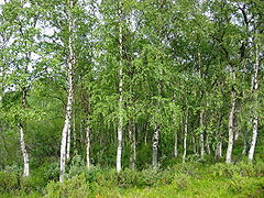
Nowadays, the upper regions of the river are dominated by birch
and pine-birch grass-shrub forests and in the middle regions there are swampy pine forests. In St. Petersburg, along the Neva, there are many gardens and parks, including the Summer Garden
, Field of Mars
, Rumyantsev, Smolny
, Alexander Garden
s, Garden of the Alexander Nevsky Lavra
and many others.
Because of the rapid flow, cold water and lack of quiet pools and aquatic vegetation the diversity of fish species in Neva is small. Permanent residents include such undemanding to environment species as perch
, ruffe
and roaches
. Many fish species are transitory, of which commercial value have smelt
, vendace
and partly salmon
.
. They are registered when the water rises above 160 cm with respect to a gauge at the Mining Institute
. More than 300 floods occurred after the city was founded in 1703. Three of them were catastrophic: on 7 November 1824, when water rose to 421 cm; on 23 September 1924 (369 cm) and 10 September 1777 (321 cm) and (321 cm). However, a much larger flood of 760 cm was described in 1691.
Besides flooding as a result of tidal waves, in 1903, 1921 and 1956 floods were caused by the melting of snow.
|+ Floods in St. Petersburg
|width="25%"|
|width="25%"|
|width="25%"|
|width="25%"|
|-
|7 November 1824, in front of Bolshoi Theatre
|7 November 1824
|Sadovaya Street near the former Nikolsky Market, 15 November 1903
|Bolshaya Podyacheskaya Street, 25 November 1903
|-
|
|
|
|
|-
|Boat transportation over Vasilievsky Island
during the flood of 23 September 1924
|Vladimirsky Avenue after the flood of 1924
|A pier during the flood of 18 October 1967
|Near the Mining Institute
on 18 October 1967
|}>
, zinc
, manganese
, nitrite
s and nitrogen
. The dirties tributaries of Neva are Mga, Slavyanka, Ohta and Chernaya. Hundreds of factories pour wastewaters into Neva within St. Petersburg and petroleum
is regularly transported along the river. The annual income of pollutants is 80,000 tonnes, and the heaviest polluters are Power-and-heating Plant 2 , "Plastpolymer" and "Obukhov State Plant
". The biggest polluters in the Leningrad Oblast are the cities of Shlisselburg, Kirovsk and Otradnoye, as well as the Kirov TPS
. More than 40 oil spills are registered on the river every year. In 2008, the Federal Service of St. Petersburg announced that no beach of Neva is fit for swimming.
Cleaning of waste water in St. Petersburg was started in 1979 and by 1997 about 74% of wastewater was purified. This number rose to 85% in 2005, to 91.7% by 2008, and is expected to reach 100% by 2011 with the completion of the expansion of the main sewerage plant.
(Votes
and Izhorians
) moved to this area from the Ural Mountains
.
In the 8 and 9th centuries AD, the area was inhabited by the East Slavs
who were mainly engaged in slash and burn
agriculture, hunting and fishing. In the 8 to 13th centuries, Neva provided a waterway from Scandinavia to the Byzantine Empire
. From the 9th century, the area belonged to Veliky Novgorod
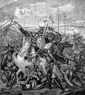
. Neva is already mentioned in the Life of Alexander Nevsky
(13 century). At that time, Veliky Novgorod was engaged in nearly constant wars with Sweden. A major battle occurred on 15 July 1240 at the confluence of the Izhora and Neva Rivers. The Russian army, led by the 20-year-old Prince Alexander Yaroslavich
, aimed to stop the planned Swedish invasion. The Swedish army was defeated; the prince showed personal courage in combat and received the honorary name of "Nevsky".
As a result of the Russian defeat in the Ingrian War
of 1610–1617 and the concomitant Treaty of Stolbovo
, the area of the Neva River became part of Swedish Ingria
. Beginning in 1642, the capital of Ingria was Nyen, a city near the Nyenschantz fortress. Because of financial and religious oppression, much of the Orthodox
population left the Neva region, emptying 60% of the villages by 1620. The abandoned areas became populated by people from the Karelian Isthmus
and Savonia
.
of 1700–1721, the valley of Neva River became part of Russian Empire
. On 16 May 1703, the city of St. Petersburg was founded in the mouth of Neva and became capital of Russia in 1712. Neva became the central part of the city. It was cleaned, intersected with canals and enclosed with embankments. In 1715, construction began of the first wooden embankment between the Admiralty building
and the Summer Garden
. In the early 1760s works started to cover it in granite
and to build bridges across Neva and its canals and tributaries, such as the Hermitage Bridge
.
From 1727 to 1916, the temporary Isaakievsky pontoon bridge
was early constructed between the modern Saint Isaac's Square and Vasilievsky Island
. A similar, but much longer (500 m) Trinity pontoon bridge was brought from the Summer Garden to Petrogradsky Island
. The first permanent bridge across Neva, Blagoveshchensky Bridge, was opened in 1850, and the second, Liteyny Bridge
, came into operation in 1879.
In 1858, a "Joint-stock company St. Petersburg water supply" was established, which built the first water supply network in the city. A two-stage water purification station was constructed in 1911. The development of the sewerage system began only in 1920, after the October Revolution
, and by 1941, the sewerage network was 1,130 km long.
Every winter from 1895 to 1910, electric tram
ways were laid on the ice of the river, connecting the Senate Square, Vasilievsky island
, Palace Embankment
and other parts of the city. The power was supplied through the rails and a top cable supported by wooden piles frozen into the ice. The service was highly successful and ran without major accidents except for a few failures in the top electrical wires. The trams ran at the speed of 20 km/h and could carry 20 passengers per carriage. The carriages were converted from the used horsecar
s. About 900,000 passengers were transported over a regular season between 20 January and 21 March. The sparking of contacts at the top wires amused spectators in the night.
, was built in 1936. During World War II, from 8 September 1941 to 27 January 1944 Leningrad was in the devastating German Siege
. On 30 August 1941, the German army captured Mga and came to Neva. On 8 September Germans captured Shlisselburg and cut all land communications and waterways to St. Petersburg (then Leningrad). The siege was partly relieved in January 1943, and ended on 27 January 1944.
A river station was built above the Volodarsky Bridge
in 1970 which could accept 10 large ships at a time. Wastewater treatment plants were built in Krasnoselsk in 1978, on the Belyi Island in 1979–1983, and in Olgino
in 1987–1994. The South-West Wastewater Treatment Plant was constructed in 2003–2005.
and Vologda
; apatite
, granite
and diabase
from Kola Peninsula
; cast iron
and steel
from Cherepovets
; coal from Donetsk
and Kuznetsk
; pyrite
from Ural; potassium chloride
from Solikamsk
; oil from Volga region. There are also many passenger routes to Moscow
, Astrakhan
, Rostov
, Perm
, Nizhny Novgorod
, Valaam
and other destinations. Navigation season on the Neva River runs from late April to November.
To the west of Shlisselburg, an oil pipeline runs under the river. The pipeline is part of the Baltic Pipeline System
, which provides oil from Timan-Pechora plate, West Siberia
, Ural, Kazakhstan
and Primorsk
to the Gulf of Finland. The 774 meter long pipeline lies 7–9 meters below the river bottom and transits about 42 million tonnes of oil a year.
Near the Ladozhsky Bridge
there is an underwater tunnel to host a gas pipeline
Nord Stream. The tunnel has diameter of 2 meters, length of 750 meters and is laid at a maximum depth of 25 meters.
Neva is the main source of water (96%) of St. Petersburg and its suburbs. From 26 June 2009, St. Petersburg started processing the drinking water by ultraviolet light, abandoning the use of chlorine for disinfection. Neva also has developed fishery, both commercial and recreational.
:
St. Petersburg:
St. Petersburg, delta of Neva River
Construction of the Novo-Admiralteisky Bridge
, a movable drawbridge
across the river, has been approved, but will not commence before 2011.
, which was built in 1323 on the Orekhovy Island at the source of Neva River, south-west of the Petrokrepost Bay, near the city of Shlisselburg
. The waterfront of Schlisselburg has a monument of Peter I. In the city, there are Blagoveshchensky Cathedral (1764–1795) and a still functioning Orthodox church of St. Nicholas, built in 1739. On the river bank stands the Church of the Intercession. Raised in 2007, it is a wooden replica of a historical church which stood on the southern shore of Lake Onega. That church was constructed in 1708 and it burned down in 1963. It is believed to be the forerunner of the famous Kizhi Pogost
.
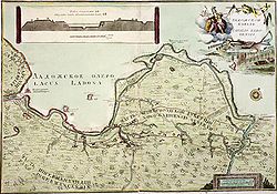
Old Ladoga Canal
, built in the first half of the 18th century, is a water transport route along the shore of Lake Ladoga which is connecting the River Volkhov and Neva. Some of its historical structures are preserved, such as a four-chamber granite sluice (1836) and a bridge (1832).
airliner performed an emergency water landing
on Neva near the Finland Railway Bridge
. The plane took off from Tallinn
-Ülemiste Airport (TLL) at 08:55 on August 21, 1963 with 45 passengers and 7 crew on board and was scheduled to land at Moscow
-Vnukovo (VKO
). After liftoff, the crew noticed that the nose gear undercarriage did not retract, and the ground control
diverted the flight to Leningrad
(LED
) – because of fog
at Tallinn. While circling above St. Petersburg at the altitude of at 1650 feet (502.9 m), under unclear circumstances (lack of fuel was one of the factors), both engines stalled. The crew performed emergency landing on the Neva River barely missing some of its bridges and a 1898-built steam tugboat
. The tugboat rushed to the plane and towed it to the shore. No casualties were sustained at any stage. The plane captain was first fired from job but then restored and awarded with the Order of the Red Star
.
River
A river is a natural watercourse, usually freshwater, flowing towards an ocean, a lake, a sea, or another river. In a few cases, a river simply flows into the ground or dries up completely before reaching another body of water. Small rivers may also be called by several other names, including...
in northwestern Russia
Russia
Russia or , officially known as both Russia and the Russian Federation , is a country in northern Eurasia. It is a federal semi-presidential republic, comprising 83 federal subjects...
flowing from Lake Ladoga
Lake Ladoga
Lake Ladoga is a freshwater lake located in the Republic of Karelia and Leningrad Oblast in northwestern Russia, not far from Saint Petersburg. It is the largest lake in Europe, and the 14th largest lake by area in the world.-Geography:...
through the western part of Leningrad Oblast
Leningrad Oblast
Leningrad Oblast is a federal subject of Russia . It was established on August 1, 1927, although it was not until 1946 that the oblast's borders had been mostly settled in their present position...
(historical region of Ingria
Ingria
Ingria is a historical region in the eastern Baltic, now part of Russia, comprising the southern bank of the river Neva, between the Gulf of Finland, the Narva River, Lake Peipus in the west, and Lake Ladoga and the western bank of the Volkhov river in the east...
) to the Neva Bay
Neva Bay
The Neva Bay , also known as the Gulf of Kronstadt, is the easternmost part of the Gulf of Finland between Kotlin Island and the Neva River estuary where the city of St. Petersburg is sited....
of the Gulf of Finland
Gulf of Finland
The Gulf of Finland is the easternmost arm of the Baltic Sea. It extends between Finland and Estonia all the way to Saint Petersburg in Russia, where the river Neva drains into it. Other major cities around the gulf include Helsinki and Tallinn...
. Despite its modest length (74 km), it is the third largest river in Europe
Europe
Europe is, by convention, one of the world's seven continents. Comprising the westernmost peninsula of Eurasia, Europe is generally 'divided' from Asia to its east by the watershed divides of the Ural and Caucasus Mountains, the Ural River, the Caspian and Black Seas, and the waterways connecting...
in terms of average discharge (after the Volga and the Danube
Danube
The Danube is a river in the Central Europe and the Europe's second longest river after the Volga. It is classified as an international waterway....
).
The Neva is the only river flowing from Lake Ladoga
Lake Ladoga
Lake Ladoga is a freshwater lake located in the Republic of Karelia and Leningrad Oblast in northwestern Russia, not far from Saint Petersburg. It is the largest lake in Europe, and the 14th largest lake by area in the world.-Geography:...
. It flows through the city Saint Petersburg
Saint Petersburg
Saint Petersburg is a city and a federal subject of Russia located on the Neva River at the head of the Gulf of Finland on the Baltic Sea...
, three smaller towns of Shlisselburg
Shlisselburg
Shlisselburg is a town in Leningrad Oblast, Russia, situated at the head of the Neva River on Lake Ladoga, east of St. Petersburg. From 1944 to 1992, it was known as Petrokrepost...
, Kirovsk
Kirovsk, Leningrad Oblast
Kirovsk is a town and the administrative center of Kirovsky District of Leningrad Oblast, Russia, located on the left bank of the Neva River, east of St. Petersburg. Population:...
and Otradnoye, and dozens of settlements. The river is navigable throughout and is part of the Volga–Baltic Waterway and White Sea – Baltic Canal. It is a site of numerous major historical events, including the Battle of the Neva
Battle of the Neva
The Battle of the Neva was fought between the Novgorod Republic and Swedish armies on the Neva River, near the settlement of Ust-Izhora, on July 15, 1240...
in 1240 which gave Alexander Nevsky
Alexander Nevsky
Alexander Nevsky was the Prince of Novgorod and Grand Prince of Vladimir during some of the most trying times in the city's history. Commonly regarded as the key figure of medieval Rus, Alexander was the grandson of Vsevolod the Big Nest and rose to legendary status on account of his military...
his name, the founding of Saint Petersburg in 1703, and the Siege of Leningrad
Siege of Leningrad
The Siege of Leningrad, also known as the Leningrad Blockade was a prolonged military operation resulting from the failure of the German Army Group North to capture Leningrad, now known as Saint Petersburg, in the Eastern Front theatre of World War II. It started on 8 September 1941, when the last...
by the German army during World War II
World War II
World War II, or the Second World War , was a global conflict lasting from 1939 to 1945, involving most of the world's nations—including all of the great powers—eventually forming two opposing military alliances: the Allies and the Axis...
.
Etymology
There are at least three versions of the origin of the name Neva: from the ancient Finnish name of Lake Ladoga ( meaning sea), from the (short from ) meaning swamp, or from the – new river. Modern names for the distributariesDistributary
A distributary, or a distributary channel, is a stream that branches off and flows away from a main stream channel. They are a common feature of river deltas. The phenomenon is known as river bifurcation. The opposite of a distributary is a tributary...
of the river delta
River delta
A delta is a landform that is formed at the mouth of a river where that river flows into an ocean, sea, estuary, lake, reservoir, flat arid area, or another river. Deltas are formed from the deposition of the sediment carried by the river as the flow leaves the mouth of the river...
were settled only by the end of the 18th century.
The history of the delta
In the PaleozoicPaleozoic
The Paleozoic era is the earliest of three geologic eras of the Phanerozoic eon, spanning from roughly...
, 300–400 million years ago, the entire territory of the modern delta
River delta
A delta is a landform that is formed at the mouth of a river where that river flows into an ocean, sea, estuary, lake, reservoir, flat arid area, or another river. Deltas are formed from the deposition of the sediment carried by the river as the flow leaves the mouth of the river...
of the Neva River was covered by a sea. Modern relief was formed as a result of glacier activity. Its retreat formed the Littorina Sea
Littorina Sea
Littorina Sea is a geological brackish-water stage of the Baltic Sea, which existed around 7500–4000 BP and followed the Mastogloia Sea, transitional stage of the Ancylus Lake...
, the water level of which was some 7–9 meters higher than the present level of the Baltic Sea. Then, the Tosna River
Tosna River
Tosna River is a river in Leningrad Oblast, Russia, a left tributary of Neva River. The towns of Tosno, Nikolskoye, and Otradnoye are located along the Tosna .Sablinskiye Caves are located by the Tosna River....
was flowing in the modern bed of the Neva, from east to west into the Litorinal Sea. In the north of the Karelian Isthmus
Karelian Isthmus
The Karelian Isthmus is the approximately 45–110 km wide stretch of land, situated between the Gulf of Finland and Lake Ladoga in northwestern Russia, to the north of the River Neva . Its northwestern boundary is the relatively narrow area between the Bay of Vyborg and Lake Ladoga...
, the Littorina Sea united by a wide strait with Lake Ladoga
Lake Ladoga
Lake Ladoga is a freshwater lake located in the Republic of Karelia and Leningrad Oblast in northwestern Russia, not far from Saint Petersburg. It is the largest lake in Europe, and the 14th largest lake by area in the world.-Geography:...
. The Mga River
Mga River
Mga is a river in Leningrad Oblast in northwestern Russia. Mga is a left tributary of Neva River. The settlement of Mga is located along it....
then flowed to the east, into Lake Ladoga, near the modern source of the Neva River; the Mga then was separated from the basin of the Tosna.
Near the modern Lake Ladoga, land rose faster, and a closed reservoir was formed. Its water level began to rise, eventually flooded the valley of Mga and broke into the valley of the river Tosna. The Ivanovo rapid
Rapid
A rapid is a section of a river where the river bed has a relatively steep gradient causing an increase in water velocity and turbulence. A rapid is a hydrological feature between a run and a cascade. A rapid is characterised by the river becoming shallower and having some rocks exposed above the...
s of the modern Neva were created in the breakthrough area. So about 2000 BC the Neva was created with its tributaries Tosna and Mga. According to some newer data, it happened at 1410–1250 BC making the Neva a rather young river. The valley of Neva is formed by glacial and post-glacial sediments and it did not change much over the past 2500 years. The delta of Neva was formed at that time, which is actually pseudodelta, as it was formed not by accumulation of river material but by plunging into the past sediments.
Topography and hydrography
Neva flows from Lake LadogaLake Ladoga
Lake Ladoga is a freshwater lake located in the Republic of Karelia and Leningrad Oblast in northwestern Russia, not far from Saint Petersburg. It is the largest lake in Europe, and the 14th largest lake by area in the world.-Geography:...
near Shlisselburg
Shlisselburg
Shlisselburg is a town in Leningrad Oblast, Russia, situated at the head of the Neva River on Lake Ladoga, east of St. Petersburg. From 1944 to 1992, it was known as Petrokrepost...
, runs on the Neva Lowland and falls into the Gulf of Finland
Gulf of Finland
The Gulf of Finland is the easternmost arm of the Baltic Sea. It extends between Finland and Estonia all the way to Saint Petersburg in Russia, where the river Neva drains into it. Other major cities around the gulf include Helsinki and Tallinn...
, Baltic Sea
Baltic Sea
The Baltic Sea is a brackish mediterranean sea located in Northern Europe, from 53°N to 66°N latitude and from 20°E to 26°E longitude. It is bounded by the Scandinavian Peninsula, the mainland of Europe, and the Danish islands. It drains into the Kattegat by way of the Øresund, the Great Belt and...
. Its length is 74 km and the shortest distance from the source to the mouth is 45 km. The river banks are low and steep, on average about 3–6 meters and 2–3 meters in the mouth. There are three sharp turns: the Ivanov rapids, at Nevsky Forest Park of the Ust-Slavyanka region (the so-called crooked knee) and near the Smolny Institute, below the mouth of the river Ohta. The average decline of the river is 4.27 meters. At one point the river crosses a moraine
Moraine
A moraine is any glacially formed accumulation of unconsolidated glacial debris which can occur in currently glaciated and formerly glaciated regions, such as those areas acted upon by a past glacial maximum. This debris may have been plucked off a valley floor as a glacier advanced or it may have...
ridge and forms the Ivanov rapids. There, at the beginning of the rapids is the narrowest place of the river (210 m). The average flow rate in the rapids is about 0.8–1.1 m/s. The average width along the river is 400–600 m. The widest places (1000–1250 m) are in the delta, near the gates of Sea trading port, at the end of the Ivanovo rapids near the confluence of the river Tosna, and near the island Fabrinchny near the source. The average depth is 8–11 m; the maximum of 24 m is reached above the Liteyny Bridge
Liteyny Bridge
The Liteyny Bridge is the second permanent bridge across the Neva river in Saint Petersburg, Russia. It connects Liteyny Prospekt with Vyborgsky district. The bridge's length is 396 meters, the width is 34 meters...
and the minimum (4.0–4.5 m) is in Ivanov rapids.
In the area of Neva basin, rainfall greatly exceeds evaporation; the latter accounts for only 37.7% of the water consumption from Neva and the remaining 62.3% is water runoff. Since 1859, the largest volume of 116 km³ was observed in 1924 and the lowest in 1900 (40.2 km³). The average annual water consumption is 78.9 km³ (2500 m³/s on average). Because of the uniform water flow from Lake Ladoga to Neva over the whole year, there is almost no flood
Flood
A flood is an overflow of an expanse of water that submerges land. The EU Floods directive defines a flood as a temporary covering by water of land not normally covered by water...
s and corresponding water rise in the spring. Neva freezes throughout from early December to early April. The ice thickness is 0.3–0.4 m within Saint Petersburg and 0.5–0.6 m in other areas. Ice congestions may form in winter in the upper reaches of the river, this sometimes causes upstream floods. Of the total ice volume of Lake Ladoga (10.6 km³) only less than 5% is brought to Neva. Average summer water temperature is 17–20 °C. Swimming season is short and lasts only about 1.5 months. Water is fresh, with medium turbidity; the average salinity is 61.3 mg/L and the calcium bicarbonate
Calcium bicarbonate
Calcium bicarbonate , also called calcium hydrogencarbonate, does not refer to a known solid compound; it exists only in aqueous solution containing the calcium , bicarbonate , and carbonate ions, together with dissolved carbon dioxide...
content is 7 mg/L.
| Quantity | April to June |
July to September |
October to November |
December to March |
Total |
|---|---|---|---|---|---|
| Runoff, km³ | 22.7 (28.5%) | 23.5 (29.4%) | 14.1 (17.7%) | 19.4 (24.4%) | 79.7 |
| Suspended sediment, kt Ton The ton is a unit of measure. It has a long history and has acquired a number of meanings and uses over the years. It is used principally as a unit of weight, and as a unit of volume. It can also be used as a measure of energy, for truck classification, or as a colloquial term.It is derived from... |
162 (31.7%) | 136 (26.7%) | 143 (28.0%) | 69 (13.6%) | 510 |
| Bottom sediments, kt | 26.5 (40.8%) | 15.8 (24.3%) | 21.3 (32.7%) | 1.4 ( 2.2%) | 65.0 |
| Ions runoff, kt | 735 (25.6%) | 729 (25.4%) | 712 (24.8%) | 694 (24.2%) | 2870 |
| Heat sink, 1015 cal Calorie The calorie is a pre-SI metric unit of energy. It was first defined by Nicolas Clément in 1824 as a unit of heat, entering French and English dictionaries between 1841 and 1867. In most fields its use is archaic, having been replaced by the SI unit of energy, the joule... |
168 (28.4%) | 359 (60.7%) | 63 (10.7%) | 1 (0.2%) | 591 |
| Ice runoff, km³ | 0.57 (81.4%) | – | 0.13 (18.6%) | – | 0.7 |
 |
||
| View on the mouth of Ladoga Canal Ladoga Canal Ladoga Canal is a historical water transport route, now situated in Leningrad Oblast, linking the Neva and the Svir River so as to bypass the stormy waters of Lake Ladoga which lies immediately to the north... and on the Neva |
Neva at the mouth of the Izhora River Izhora River The Izhora , also known as Inger River, is a left tributary of the Neva River on its run through Ingria in northwestern Russia from Lake Ladoga to Gulf of Finland. A settlement of Ust-Izhora is situated at the confluence of Izhora and Neva, halfway between Saint Petersburg and Schlisselburg. The... |
Neva near the Peter the Great Bridge Peter the Great Bridge Bolsheokhtinsky Bridge is a bridge across the Neva River in Saint Petersburg, Russia. The bridge's length is 334 meters, the width is 23 meters. The bridge features only three spans, the central one can be drawn.-History:... |
Basin, tributaries and distributaries
The basin area of Neva is 5,000 km², including the pools of Lake Ladoga and Onega (281 km²). The basin contains 26,300 lakes and has a complex hydrological network of more than 48,300 rivers, however only 26 flow directly into Neva. Main tributaries are MgaMga River
Mga is a river in Leningrad Oblast in northwestern Russia. Mga is a left tributary of Neva River. The settlement of Mga is located along it....
, Tosna
Tosna River
Tosna River is a river in Leningrad Oblast, Russia, a left tributary of Neva River. The towns of Tosno, Nikolskoye, and Otradnoye are located along the Tosna .Sablinskiye Caves are located by the Tosna River....
, Izhora
Izhora River
The Izhora , also known as Inger River, is a left tributary of the Neva River on its run through Ingria in northwestern Russia from Lake Ladoga to Gulf of Finland. A settlement of Ust-Izhora is situated at the confluence of Izhora and Neva, halfway between Saint Petersburg and Schlisselburg. The...
, Slavyanka
Slavyanka River
Slavyanka is a river in Leningrad Oblast of Russia. It is a tributary of the Neva River, and it is 31 km long, with a drainage basin of 230 km²....
and Murzinka on the left, and Okhta
Okhta River, Neva basin
Okhta River is a river in Leningrad Oblast and the eastern part of the city of Saint Petersburg, Russia. It is the largest right tributary of the Neva river. It joins the Neva 12 km upstream of the Neva's mouth, within the city limits of Saint Petersburg. Rzhevsky reservoir has been built on...
and Chernaya River
Chernaya River (Saint Petersburg)
The Chernaya River , originally Mustajogi also known as the Tchernaya Rechka or Black River, is a small river in Saint Petersburg....
on the right side of Neva.
The hydrological network had been altered by the development of St. Petersburg through its entire history. When it was founded in 1703, the area was low and swampy and required construction of canals and ponds for drainage. The earth excavated during their construction was used to raise the city. At the end of 19 century, the delta of Neva consisted of 48 rivers and canals and 101 islands. The most significant distributaries of the delta are listed in the table. Before construction of the Obvodny Canal
Obvodny Canal
Obvodny Canal is the longest canal in Saint Petersburg, Russia, which in the 19th century served as the southern limit of the city. It is 8 km long and flows from the Neva River near Alexander Nevsky Lavra to the Yekaterinhofka not far from the sea port. The canal was dug in 1769-1780 and 1805-1833...
, the left tributary of that area was Volkovka River; its part at the confluence is now called Monastyrka River. The Ladoga Canal
Ladoga Canal
Ladoga Canal is a historical water transport route, now situated in Leningrad Oblast, linking the Neva and the Svir River so as to bypass the stormy waters of Lake Ladoga which lies immediately to the north...
starts at the root of Neva and connects it along the southern coast of Lake Ladoga with Volkhov River
Volkhov River
Volkhov is a river in Novgorod Oblast and Leningrad Oblast in northwestern Russia.-Geography:The Volkhov flows out of Lake Ilmen north into Lake Ladoga, the largest lake of Europe. It is the second largest tributary of Lake Ladoga. It is navigable over its whole length. Discharge is highly...
.
Some canals of the delta were filled over time, so that only 42 islands remained by 1972, all within the city limits of St. Petersburg. The largest islands are Vasilievsky
Vasilievsky Island
Vasilyevsky Island is an island in Saint Petersburg, Russia, bordered by the rivers Bolshaya Neva and Malaya Neva in the south and northeast, and by the Gulf of Finland in the west. Vasilyevsky Island is separated from Dekabristov Island by the Smolenka River...
(1050 ha
Hectare
The hectare is a metric unit of area defined as 10,000 square metres , and primarily used in the measurement of land. In 1795, when the metric system was introduced, the are was defined as being 100 square metres and the hectare was thus 100 ares or 1/100 km2...
), Petrogradsky
Petrogradsky Island
Petrogradsky Island is the third largest island in the Neva River deltain Saint Petersburg, Russia.Along with Zayachy Island, Aptekarsky Island, and Petrovsky Island,it constitutes the Petrogradskaya Side...
(570 ha), Krestovsky
Krestovsky Island
Krestovsky Island is a 3.4 km² island in Saint Petersburg, Russia, situated between several tributaries of the Neva: the Srednyaya Nevka, the Malaya Nevka and the Krestovka. The island is served by the Krestovsky Ostrov "Крестовский остров" station of Saint Petersburg Metro...
(420 ha) and Dekabristov (410 hectares); others include Zayachy
Zayachy Island
Zayachy Island is an island in the Neva River in St. Petersburg, Russia...
, Yelagin and Kamenny Island
Kamenny Island
Kamenny Ostrov, Kamenny Island, or Stony Island is one of the islands in the Neva delta. It is part of Saint Petersburg, Russia....
s. At the source of the Neva, near Shlisselburg
Shlisselburg
Shlisselburg is a town in Leningrad Oblast, Russia, situated at the head of the Neva River on Lake Ladoga, east of St. Petersburg. From 1944 to 1992, it was known as Petrokrepost...
, there are the two small islands of Orekhovy and Fabrichny. Island Glavryba lies up the river, above the town of Otradnoye.
| Name | Region | Length, km |
|---|---|---|
| Bolshaya Neva Bolshaya Neva Bolshaya Neva is the largest armlet of Neva river. It starts near the Vasilievsky Island's Strelka .The length of Bolshaya Neva is 3.5 km, the width is from 200 to 400 meters, depth up to 12.8 meters... |
from the mouth of the Fontanka Fontanka Fontanka is a left branch of the river Neva, which flows through the whole of Central Saint Petersburg, Russia. Its length is 6,700 meters, its width is up to 70 meters, and its depth is up to 3,5 meters. The Fontanka Embankment is lined with the former private residences of Russian nobility.This... to the Blagoveshchensky Bridge |
2.40 |
| From the Blagoveshchensky Bridge to the Palace Bridge Palace Bridge Palace Bridge is a road traffic and foot bascule bridge spanning the Neva River in Saint Petersburg between Palace Square and Vasilievsky Island. Like every other Neva bridge , it is drawn by night, making foot travel between various parts of the city virtually impossible... |
1.22 | |
| Malaya Neva Malaya Neva Malaya Neva is the second largest distributary of the Neva River. The Neva splits into Bolshaya Neva and Malaya Neva near the Vasilievsky Island's Strelka , in the historic center of the city of Saint Petersburg.The length of Malaya Neva is 4.25 km, the width is from 200 to 400 meters, depth is... |
4.85 | |
| Ekateringofka | 3.60 | |
| Zhdanovka Zhdanovka River The Zhdanovka River is a short river in the Neva River delta in Saint Petersburg, Russia. It separates Petrogradsky Island from Petrovsky Island.-History:... |
2.20 | |
| Smolenka Smolenka River Smolenka is a minor river in the city of Saint Petersburg, Russia. It is one of the armlets of the Neva River forming its delta. It branches off the Malaya Neva armlet at , and flows through the Smolensky Cemetery into the Gulf of Finland, separating Decembrists' Island from the Vasilievsky... |
3.30 | |
| Bolshaya Nevka | from the Neva to Malaya Nevka Malaya Nevka Malaya Nevka is the southern distributary of the Bolshaya Nevka. The Bolshaya Nevka splits into Malaya Nevka and Srednaya Nevka near the Kamenny Island's easternmost tip.... |
3.70 |
| from Malaya Nevka to Middle Nevka | 2.05 | |
| From Middle Nevka to Neva Bay Neva Bay The Neva Bay , also known as the Gulf of Kronstadt, is the easternmost part of the Gulf of Finland between Kotlin Island and the Neva River estuary where the city of St. Petersburg is sited.... |
2.15 | |
| Middle Nevka | 2.60 | |
| Malaya Nevka Malaya Nevka Malaya Nevka is the southern distributary of the Bolshaya Nevka. The Bolshaya Nevka splits into Malaya Nevka and Srednaya Nevka near the Kamenny Island's easternmost tip.... |
4.90 | |
| Karpovka Karpovka River The Karpovka is a small river of the Neva basin in Saint Petersburg, Russia. It separates Aptekarsky Island from Petrogradsky Island . The Karpovka flows from the Bolshaya Nevka to the Malaya Nevka and is 3 km long. The Russian name is derived from the old Finnish name of the river, Korpijoki... |
3.00 | |
| Krestovka | 0.74 | |
| Fontanka Fontanka Fontanka is a left branch of the river Neva, which flows through the whole of Central Saint Petersburg, Russia. Its length is 6,700 meters, its width is up to 70 meters, and its depth is up to 3,5 meters. The Fontanka Embankment is lined with the former private residences of Russian nobility.This... |
6.70 | |
| Moyka | 4.67 | |
| Griboyedov Canal | 5.00 | |
| Pryazhka | 1.32 | |
| Kryukov Canal | 1.15 | |
| Obvodny Canal Obvodny Canal Obvodny Canal is the longest canal in Saint Petersburg, Russia, which in the 19th century served as the southern limit of the city. It is 8 km long and flows from the Neva River near Alexander Nevsky Lavra to the Yekaterinhofka not far from the sea port. The canal was dug in 1769-1780 and 1805-1833... |
8.08 |
Flora and fauna
Podsol
In soil science, podzols are the typical soils of coniferous, or boreal forests. They are also the typical soils of eucalypt forests and heathlands in southern Australia...
, gleysols
Gleysols
A Gleysol in the FAO World Reference Base for Soil Resources is a wetland soil that, unless drained, is saturated with groundwater for long enough periods to develop a characteristic gleyic colour pattern...
, peat
Peat
Peat is an accumulation of partially decayed vegetation matter or histosol. Peat forms in wetland bogs, moors, muskegs, pocosins, mires, and peat swamp forests. Peat is harvested as an important source of fuel in certain parts of the world...
and boggy peat soils. Several centuries ago, the whole territory of the Neva lowland was covered by pine
Pine
Pines are trees in the genus Pinus ,in the family Pinaceae. They make up the monotypic subfamily Pinoideae. There are about 115 species of pine, although different authorities accept between 105 and 125 species.-Etymology:...
and spruce
Norway Spruce
Norway Spruce is a species of spruce native to Europe. It is also commonly referred to as the European Spruce.- Description :...
moss
Moss
Mosses are small, soft plants that are typically 1–10 cm tall, though some species are much larger. They commonly grow close together in clumps or mats in damp or shady locations. They do not have flowers or seeds, and their simple leaves cover the thin wiry stems...
y forests. They were gradually reduced by the fires and cutting for technical needs. Extensive damage was caused during World War II
World War II
World War II, or the Second World War , was a global conflict lasting from 1939 to 1945, involving most of the world's nations—including all of the great powers—eventually forming two opposing military alliances: the Allies and the Axis...
: in St. Petersburg, the forests were reduced completely, and in the upper reaches down to 40–50%. Forest were replanted after the war with spruce, pine, cedar, Siberian larch, oak
Oak
An oak is a tree or shrub in the genus Quercus , of which about 600 species exist. "Oak" may also appear in the names of species in related genera, notably Lithocarpus...
, Norway maple, elm
Elm
Elms are deciduous and semi-deciduous trees comprising the genus Ulmus in the plant family Ulmaceae. The dozens of species are found in temperate and tropical-montane regions of North America and Eurasia, ranging southward into Indonesia. Elms are components of many kinds of natural forests...
, America, ash, apple
Apple
The apple is the pomaceous fruit of the apple tree, species Malus domestica in the rose family . It is one of the most widely cultivated tree fruits, and the most widely known of the many members of genus Malus that are used by humans. Apple grow on small, deciduous trees that blossom in the spring...
tree, mountain ash
Mountain Ash
Mountain Ash is a name used for several trees, none of immediate relation. It may refer to:* Eucalyptus regnans, the tallest of all flowering plants and other floral species* Fraxinus texensis, an ash tree species in Texas...
and other species. The shrubs include barberry
Berberis
Berberis , the barberries or pepperidge bushes, is a genus of about 450-500 species of deciduous and evergreen shrubs from 1-5 m tall with thorny shoots, native to the temperate and subtropical regions of Europe, Asia, Africa, North America and South America. They are closely related to the genus...
, lilac, jasmine
Jasmine
Jasminum , commonly known as jasmines, is a genus of shrubs and vines in the olive family . It contains around 200 species native to tropical and warm temperate regions of the Old World...
, hazel
Hazel
The hazels are a genus of deciduous trees and large shrubs native to the temperate northern hemisphere. The genus is usually placed in the birch family Betulaceae, though some botanists split the hazels into a separate family Corylaceae.They have simple, rounded leaves with double-serrate margins...
, honeysuckle
Honeysuckle
Honeysuckles are arching shrubs or twining vines in the family Caprifoliaceae, native to the Northern Hemisphere. There are about 180 species of honeysuckle, 100 of which occur in China; Europe, India and North America have only about 20 native species each...
, hawthorn
Crataegus
Crataegus , commonly called hawthorn or thornapple, is a large genus of shrubs and trees in the rose family, Rosaceae, native to temperate regions of the Northern Hemisphere in Europe, Asia and North America. The name hawthorn was originally applied to the species native to northern Europe,...
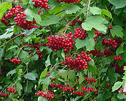
, rose hip
Rose hip
The rose hip, or rose haw, is the fruit of the rose plant, that typically is red-to-orange, but ranges from dark purple to black in some species. Rose hips begin to form in spring, and ripen in late summer through autumn.-Usage:...
, viburnum
Viburnum
Viburnum is a genus of about 150–175 species of shrubs or small trees in the moschatel family, Adoxaceae. Its current classification is based on molecular phylogeny...
, juniper
Juniper
Junipers are coniferous plants in the genus Juniperus of the cypress family Cupressaceae. Depending on taxonomic viewpoint, there are between 50-67 species of juniper, widely distributed throughout the northern hemisphere, from the Arctic, south to tropical Africa in the Old World, and to the...
, elder, shadbush and many others.
Nowadays, the upper regions of the river are dominated by birch
Birch
Birch is a tree or shrub of the genus Betula , in the family Betulaceae, closely related to the beech/oak family, Fagaceae. The Betula genus contains 30–60 known taxa...
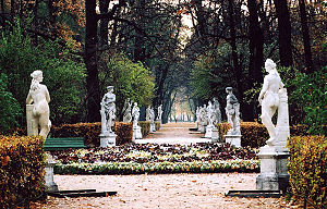
and pine-birch grass-shrub forests and in the middle regions there are swampy pine forests. In St. Petersburg, along the Neva, there are many gardens and parks, including the Summer Garden
Summer Garden
The Summer Garden occupies an island between the Fontanka, Moika, and the Swan Canal in Saint Petersburg and shares its name with the adjacent Summer Palace of Peter the Great.-Original:...
, Field of Mars
Field of Mars (Saint Petersburg)
The Field of Mars or Marsovo Polye is a large park named after the Mars - Roman god of war situated in the center of Saint-Petersburg, with an area of about 9 hectares. Bordering the Field of Mars to the north are the Marble Palace, Suvorova Square and Betskoi’s and Saltykov’s houses. To the west...
, Rumyantsev, Smolny
Smolny Convent
Smolny Convent or Smolny Convent of the Resurrection , located on Ploschad Rastrelli, on the bank of the River Neva in Saint Petersburg, Russia, consists of a cathedral and a complex of buildings surrounding it, originally intended for a convent.-History:This Russian Orthodox convent was built to...
, Alexander Garden
Alexander Garden (Saint Petersburg)
The Alexander Garden lies along the south and west façades of the Russian Admiralty in St. Petersburg, parallel to the Neva River and Admiralty Quay, extending from Palace Square in the east to St. Isaac's Cathedral in the west. The English park is named after Alexander II of Russia who ordered...
s, Garden of the Alexander Nevsky Lavra
Alexander Nevsky Lavra
Saint Alexander Nevsky Lavra or Saint Alexander Nevsky Monastery was founded by Peter I of Russia in 1710 at the eastern end of the Nevsky Prospekt in St. Petersburg supposing that that was the site of the Neva Battle in 1240 when Alexander Nevsky, a prince, defeated the Swedes; however, the battle...
and many others.
Because of the rapid flow, cold water and lack of quiet pools and aquatic vegetation the diversity of fish species in Neva is small. Permanent residents include such undemanding to environment species as perch
Perch
Perch is a common name for fish of the genus Perca, freshwater gamefish belonging to the family Percidae. The perch, of which there are three species in different geographical areas, lend their name to a large order of vertebrates: the Perciformes, from the Greek perke meaning spotted, and the...
, ruffe
Ruffe
The Eurasian Ruffe or simply Ruffe is a freshwater fish found in temperate regions of Europe and northern Asia. It has been introduced into the Great Lakes of North America, reportedly with unfortunate results...
and roaches
Rutilus
Rutilus is a genus of fishes in the family Cyprinidae, commonly called roaches. Locally, the name "roach" without any further qualifiers is also used for particular species, particularly the Common Roach Rutilus (Latin for "shining, red, golden, auburn") is a genus of fishes in the family...
. Many fish species are transitory, of which commercial value have smelt
European smelt
The Smelt or European smelt is a species of fish in the Osmeridae family.- Shape and appearance :The body of the European smelt is typically 15 to 18 cm long, slender and slightly flattened on either side. Larger fish may reach 30 cm in length. Smelts have a slightly translucent body...
, vendace
Coregonus albula
The vendace, Coregonus albula, is a species of freshwater whitefish in the family Salmonidae. It is also known as the European cisco. It is found in lakes in northern Europe, especially Finland, Sweden, Russia and Estonia, and in some lakes of the United Kingdom, northern Germany and Poland...
and partly salmon
Salmonidae
Salmonidae is a family of ray-finned fish, the only living family currently placed in the order Salmoniformes. It includes salmon, trout, chars, freshwater whitefishes and graylings...
.
 |
 |
|
| A birch forest | The Summer Garden Summer Garden The Summer Garden occupies an island between the Fontanka, Moika, and the Swan Canal in Saint Petersburg and shares its name with the adjacent Summer Palace of Peter the Great.-Original:... |
Field of Mars |
Floods
Floods in St. Petersburg are usually caused by the overflow of the delta of Neva and by surging water in the eastern part of Neva BayNeva Bay
The Neva Bay , also known as the Gulf of Kronstadt, is the easternmost part of the Gulf of Finland between Kotlin Island and the Neva River estuary where the city of St. Petersburg is sited....
. They are registered when the water rises above 160 cm with respect to a gauge at the Mining Institute
Saint Petersburg Mining Institute
The G. V. Plekhanov Saint Petersburg State Mining Institute and Technical University is Russia's oldest higher education institute devoted to engineering...
. More than 300 floods occurred after the city was founded in 1703. Three of them were catastrophic: on 7 November 1824, when water rose to 421 cm; on 23 September 1924 (369 cm) and 10 September 1777 (321 cm) and (321 cm). However, a much larger flood of 760 cm was described in 1691.
Besides flooding as a result of tidal waves, in 1903, 1921 and 1956 floods were caused by the melting of snow.
|width="25%"|
|width="25%"|
|width="25%"|
|width="25%"|
|-
|7 November 1824, in front of Bolshoi Theatre
Bolshoi Kamenny Theatre
The Saint Petersburg Imperial Bolshoi Kamenny Theatre was a theatre in Saint Petersburg.- History :It was built in 1783 to Antonio Rinaldi's Neoclassical design as the Kamenny Theatre. It was rebuilt in 1802 and renamed the Bolshoi, but burned down in 1811. The building was restored in 1818, and...
|7 November 1824
|Sadovaya Street near the former Nikolsky Market, 15 November 1903
|Bolshaya Podyacheskaya Street, 25 November 1903
|-
|
|
|
|
|-
|Boat transportation over Vasilievsky Island
Vasilievsky Island
Vasilyevsky Island is an island in Saint Petersburg, Russia, bordered by the rivers Bolshaya Neva and Malaya Neva in the south and northeast, and by the Gulf of Finland in the west. Vasilyevsky Island is separated from Dekabristov Island by the Smolenka River...
during the flood of 23 September 1924
|Vladimirsky Avenue after the flood of 1924
|A pier during the flood of 18 October 1967
|Near the Mining Institute
Saint Petersburg Mining Institute
The G. V. Plekhanov Saint Petersburg State Mining Institute and Technical University is Russia's oldest higher education institute devoted to engineering...
on 18 October 1967
|}>
Ecological condition
The Federal Service for Hydrometeorology and Environmental Monitoring of Russia classifies Neva as a "heavily polluted" river. The main pollutants are copperCopper
Copper is a chemical element with the symbol Cu and atomic number 29. It is a ductile metal with very high thermal and electrical conductivity. Pure copper is soft and malleable; an exposed surface has a reddish-orange tarnish...
, zinc
Zinc
Zinc , or spelter , is a metallic chemical element; it has the symbol Zn and atomic number 30. It is the first element in group 12 of the periodic table. Zinc is, in some respects, chemically similar to magnesium, because its ion is of similar size and its only common oxidation state is +2...
, manganese
Manganese
Manganese is a chemical element, designated by the symbol Mn. It has the atomic number 25. It is found as a free element in nature , and in many minerals...
, nitrite
Nitrite
The nitrite ion has the chemical formula NO2−. The anion is symmetric with equal N-O bond lengths and a O-N-O bond angle of ca. 120°. On protonation the unstable weak acid nitrous acid is produced. Nitrite can be oxidised or reduced, with product somewhat dependent on the oxidizing/reducing agent...
s and nitrogen
Nitrogen
Nitrogen is a chemical element that has the symbol N, atomic number of 7 and atomic mass 14.00674 u. Elemental nitrogen is a colorless, odorless, tasteless, and mostly inert diatomic gas at standard conditions, constituting 78.08% by volume of Earth's atmosphere...
. The dirties tributaries of Neva are Mga, Slavyanka, Ohta and Chernaya. Hundreds of factories pour wastewaters into Neva within St. Petersburg and petroleum
Petroleum
Petroleum or crude oil is a naturally occurring, flammable liquid consisting of a complex mixture of hydrocarbons of various molecular weights and other liquid organic compounds, that are found in geologic formations beneath the Earth's surface. Petroleum is recovered mostly through oil drilling...
is regularly transported along the river. The annual income of pollutants is 80,000 tonnes, and the heaviest polluters are Power-and-heating Plant 2 , "Plastpolymer" and "Obukhov State Plant
Obukhov State Plant
Obukhov State Plant is a major Russian metallurgy and heavy machine-building plant in St. Petersburg, Russia. It was founded in 1863 to produce naval artillery based on German designs by Krupp. It has since been a major producer of artillery and other military equipment. From 1922 to 1992 it...
". The biggest polluters in the Leningrad Oblast are the cities of Shlisselburg, Kirovsk and Otradnoye, as well as the Kirov TPS
Thermal power station
A thermal power station is a power plant in which the prime mover is steam driven. Water is heated, turns into steam and spins a steam turbine which drives an electrical generator. After it passes through the turbine, the steam is condensed in a condenser and recycled to where it was heated; this...
. More than 40 oil spills are registered on the river every year. In 2008, the Federal Service of St. Petersburg announced that no beach of Neva is fit for swimming.
Cleaning of waste water in St. Petersburg was started in 1979 and by 1997 about 74% of wastewater was purified. This number rose to 85% in 2005, to 91.7% by 2008, and is expected to reach 100% by 2011 with the completion of the expansion of the main sewerage plant.
Before 1700
Many sites of ancient people, up to nine thousand years old, were found within the territory of the Neva basin. It is believed that around 12 thousand years BC, Finno-Ugric peoplesFinno-Ugric peoples
The Finno-Ugric peoples are any of several peoples of Europe who speak languages of the proposed Finno-Ugric language family, such as the Finns, Estonians, Mordvins, and Hungarians...
(Votes
Votes
Votes are a people of Votia in Ingria, the part of modern day northwestern Russia that is roughly southwest of Saint Petersburg and east of the Estonian border-town of Narva. Their own ethnic name is Vadjalain . The Finnic Votic language spoken by Votes is close to extinction. Votians were one of...
and Izhorians
Izhorians
The Izhorians , along with the Votes are an indigenous people of Ingria. Small numbers can still be found in the Western part of Ingria, between the Narva and Neva rivers in northwestern Russia.- History :The history of the Izhorians is bound to the history of Ingria...
) moved to this area from the Ural Mountains
Ural Mountains
The Ural Mountains , or simply the Urals, are a mountain range that runs approximately from north to south through western Russia, from the coast of the Arctic Ocean to the Ural River and northwestern Kazakhstan. Their eastern side is usually considered the natural boundary between Europe and Asia...
.
In the 8 and 9th centuries AD, the area was inhabited by the East Slavs
East Slavs
The East Slavs are Slavic peoples speaking East Slavic languages. Formerly the main population of the medieval state of Kievan Rus, by the seventeenth century they evolved into the Russian, Ukrainian, and Belarusian peoples.-Sources:...
who were mainly engaged in slash and burn
Slash and burn
Slash-and-burn is an agricultural technique which involves cutting and burning of forests or woodlands to create fields. It is subsistence agriculture that typically uses little technology or other tools. It is typically part of shifting cultivation agriculture, and of transhumance livestock...
agriculture, hunting and fishing. In the 8 to 13th centuries, Neva provided a waterway from Scandinavia to the Byzantine Empire
Byzantine Empire
The Byzantine Empire was the Eastern Roman Empire during the periods of Late Antiquity and the Middle Ages, centred on the capital of Constantinople. Known simply as the Roman Empire or Romania to its inhabitants and neighbours, the Empire was the direct continuation of the Ancient Roman State...
. From the 9th century, the area belonged to Veliky Novgorod
Veliky Novgorod
Veliky Novgorod is one of Russia's most historic cities and the administrative center of Novgorod Oblast. It is situated on the M10 federal highway connecting Moscow and St. Petersburg. The city lies along the Volkhov River just below its outflow from Lake Ilmen...
. Neva is already mentioned in the Life of Alexander Nevsky
Life of Alexander Nevsky
"Life of Alexander Nevsky" , a Russian literary monument of the late 13th early 14th centuries....
(13 century). At that time, Veliky Novgorod was engaged in nearly constant wars with Sweden. A major battle occurred on 15 July 1240 at the confluence of the Izhora and Neva Rivers. The Russian army, led by the 20-year-old Prince Alexander Yaroslavich
Alexander Nevsky
Alexander Nevsky was the Prince of Novgorod and Grand Prince of Vladimir during some of the most trying times in the city's history. Commonly regarded as the key figure of medieval Rus, Alexander was the grandson of Vsevolod the Big Nest and rose to legendary status on account of his military...
, aimed to stop the planned Swedish invasion. The Swedish army was defeated; the prince showed personal courage in combat and received the honorary name of "Nevsky".
As a result of the Russian defeat in the Ingrian War
Ingrian War
The Ingrian War between Sweden and Russia, which lasted between 1610 and 1617 and can be seen as part of Russia's Time of Troubles, is mainly remembered for the attempt to put a Swedish duke on the Russian throne...
of 1610–1617 and the concomitant Treaty of Stolbovo
Treaty of Stolbovo
The Treaty of Stolbovo is a peace treaty of 1617 that ended the Ingrian War, fought between Sweden and Russia.After nearly two months of negotiations, representatives from Sweden and Russia met at the village of Stolbova, south of Lake Ladoga, on 27 February 1617.From the outset, Sweden had gone...
, the area of the Neva River became part of Swedish Ingria
Swedish Ingria
Swedish Ingria was a dominion of the Swedish Empire from 1580 to 1595 and then again from 1617 to 1721, when it was ceded to the Russian Empire in the Treaty of Nystad....
. Beginning in 1642, the capital of Ingria was Nyen, a city near the Nyenschantz fortress. Because of financial and religious oppression, much of the Orthodox
Eastern Orthodox Church
The Orthodox Church, officially called the Orthodox Catholic Church and commonly referred to as the Eastern Orthodox Church, is the second largest Christian denomination in the world, with an estimated 300 million adherents mainly in the countries of Belarus, Bulgaria, Cyprus, Georgia, Greece,...
population left the Neva region, emptying 60% of the villages by 1620. The abandoned areas became populated by people from the Karelian Isthmus
Karelian Isthmus
The Karelian Isthmus is the approximately 45–110 km wide stretch of land, situated between the Gulf of Finland and Lake Ladoga in northwestern Russia, to the north of the River Neva . Its northwestern boundary is the relatively narrow area between the Bay of Vyborg and Lake Ladoga...
and Savonia
Savonia (historical province)
Savonia is a historical province in the east of Finland. It borders to Uusimaa, Tavastia, Ostrobothnia, and Karelia. Largest cities in Savo by population are Kuopio, Mikkeli, Savonlinna and Varkaus.-Administration:...
.
 |
 |
|
| Victory of Alexander Nevsky Alexander Nevsky Alexander Nevsky was the Prince of Novgorod and Grand Prince of Vladimir during some of the most trying times in the city's history. Commonly regarded as the key figure of medieval Rus, Alexander was the grandson of Vsevolod the Big Nest and rose to legendary status on account of his military... over the Swedes by B. Chorikov |
Assault on the Oreshek Shlisselburg Shlisselburg is a town in Leningrad Oblast, Russia, situated at the head of the Neva River on Lake Ladoga, east of St. Petersburg. From 1944 to 1992, it was known as Petrokrepost... fortress on 11 October 1702 by Alexander Kotzebue Alexander Kotzebue Alexander Friedrich Wilhelm Franz von Kotzebue was a German-Russian Romantic painter of historical scenes and battle scenes.... |
Map of the Peter the Great Canal (1742) |
Russian period
As a result of the Great Northern WarGreat Northern War
The Great Northern War was a conflict in which a coalition led by the Tsardom of Russia successfully contested the supremacy of the Swedish Empire in northern Central Europe and Eastern Europe. The initial leaders of the anti-Swedish alliance were Peter I the Great of Russia, Frederick IV of...
of 1700–1721, the valley of Neva River became part of Russian Empire
Russian Empire
The Russian Empire was a state that existed from 1721 until the Russian Revolution of 1917. It was the successor to the Tsardom of Russia and the predecessor of the Soviet Union...
. On 16 May 1703, the city of St. Petersburg was founded in the mouth of Neva and became capital of Russia in 1712. Neva became the central part of the city. It was cleaned, intersected with canals and enclosed with embankments. In 1715, construction began of the first wooden embankment between the Admiralty building
Admiralty building, Saint Petersburg
The Admiralty building is the former headquarters of the Admiralty Board in St. Petersburg, russia.-History:The building you see now was re-built in the nineteenth century to support the Tsar's maritime ambitions. The original design was a fortified ship yars which was later surrounded by four...
and the Summer Garden
Summer Garden
The Summer Garden occupies an island between the Fontanka, Moika, and the Swan Canal in Saint Petersburg and shares its name with the adjacent Summer Palace of Peter the Great.-Original:...
. In the early 1760s works started to cover it in granite
Granite
Granite is a common and widely occurring type of intrusive, felsic, igneous rock. Granite usually has a medium- to coarse-grained texture. Occasionally some individual crystals are larger than the groundmass, in which case the texture is known as porphyritic. A granitic rock with a porphyritic...
and to build bridges across Neva and its canals and tributaries, such as the Hermitage Bridge
Hermitage Bridge
The Hermitage Bridge is a bridge across the Winter Canal along Palace Embankment in Saint Petersburg, Russia. The bridge constitutes part of the Hermitage and Winter Palace ensemble.- Ground location :...
.
From 1727 to 1916, the temporary Isaakievsky pontoon bridge
Isaakievsky Bridge
Isaakievsky pontoon bridge was the first bridge across Neva river in St.Petersburg, by then the capital of Russian Empire. It was first constructed in 1727. Starting from 1732 it was rebuilt each summer for a period 184 years. The bridge was named after the nearby Saint Isaac's Cathedral...
was early constructed between the modern Saint Isaac's Square and Vasilievsky Island
Vasilievsky Island
Vasilyevsky Island is an island in Saint Petersburg, Russia, bordered by the rivers Bolshaya Neva and Malaya Neva in the south and northeast, and by the Gulf of Finland in the west. Vasilyevsky Island is separated from Dekabristov Island by the Smolenka River...
. A similar, but much longer (500 m) Trinity pontoon bridge was brought from the Summer Garden to Petrogradsky Island
Petrogradsky Island
Petrogradsky Island is the third largest island in the Neva River deltain Saint Petersburg, Russia.Along with Zayachy Island, Aptekarsky Island, and Petrovsky Island,it constitutes the Petrogradskaya Side...
. The first permanent bridge across Neva, Blagoveshchensky Bridge, was opened in 1850, and the second, Liteyny Bridge
Liteyny Bridge
The Liteyny Bridge is the second permanent bridge across the Neva river in Saint Petersburg, Russia. It connects Liteyny Prospekt with Vyborgsky district. The bridge's length is 396 meters, the width is 34 meters...
, came into operation in 1879.
In 1858, a "Joint-stock company St. Petersburg water supply" was established, which built the first water supply network in the city. A two-stage water purification station was constructed in 1911. The development of the sewerage system began only in 1920, after the October Revolution
October Revolution
The October Revolution , also known as the Great October Socialist Revolution , Red October, the October Uprising or the Bolshevik Revolution, was a political revolution and a part of the Russian Revolution of 1917...
, and by 1941, the sewerage network was 1,130 km long.
Every winter from 1895 to 1910, electric tram
Tram
A tram is a passenger rail vehicle which runs on tracks along public urban streets and also sometimes on separate rights of way. It may also run between cities and/or towns , and/or partially grade separated even in the cities...
ways were laid on the ice of the river, connecting the Senate Square, Vasilievsky island
Vasilievsky Island
Vasilyevsky Island is an island in Saint Petersburg, Russia, bordered by the rivers Bolshaya Neva and Malaya Neva in the south and northeast, and by the Gulf of Finland in the west. Vasilyevsky Island is separated from Dekabristov Island by the Smolenka River...
, Palace Embankment
Palace Embankment
The Palace Embankment or Palace Quay is a street along the Neva River in Central Saint Petersburg which contains the complex of the Hermitage Museum buildings , the Hermitage Theatre, the Marble Palace, the Vladimir Palace, the New Michael Palace and the Summer Garden.The street was laid out...
and other parts of the city. The power was supplied through the rails and a top cable supported by wooden piles frozen into the ice. The service was highly successful and ran without major accidents except for a few failures in the top electrical wires. The trams ran at the speed of 20 km/h and could carry 20 passengers per carriage. The carriages were converted from the used horsecar
Horsecar
A horsecar or horse-drawn tram is an animal-powered streetcar or tram.These early forms of public transport developed out of industrial haulage routes that had long been in existence, and from the omnibus routes that first ran on public streets in the 1820s, using the newly improved iron or steel...
s. About 900,000 passengers were transported over a regular season between 20 January and 21 March. The sparking of contacts at the top wires amused spectators in the night.
 |
||
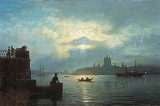
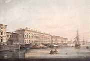
| View down the Neva River between the Winter Palace Winter Palace The Winter Palace in Saint Petersburg, Russia, was, from 1732 to 1917, the official residence of the Russian monarchs. Situated between the Palace Embankment and the Palace Square, adjacent to the site of Peter the Great's original Winter Palace, the present and fourth Winter Palace was built and... and St. Petersburg Academy of Sciences. Engraving of 1753. |
Palace Embankment Palace Embankment The Palace Embankment or Palace Quay is a street along the Neva River in Central Saint Petersburg which contains the complex of the Hermitage Museum buildings , the Hermitage Theatre, the Marble Palace, the Vladimir Palace, the New Michael Palace and the Summer Garden.The street was laid out... (1826). |
View on the Smolny Convent Smolny Convent Smolny Convent or Smolny Convent of the Resurrection , located on Ploschad Rastrelli, on the bank of the River Neva in Saint Petersburg, Russia, consists of a cathedral and a complex of buildings surrounding it, originally intended for a convent.-History:This Russian Orthodox convent was built to... from Bolshaya Ohta (1851). |
Soviet and modern periods
The first concrete bridge across Neva, the Volodarsky BridgeVolodarsky Bridge
The Volodarsky Bridge is a bridge across the Neva River in Saint Petersburg, Russia. The bridge connects Narodnaya and Ivanovskaya streets. The bridge length is 332 meters, the width is 24–27 meters. It is named after V. Volodarsky, a revolutionary, who was killed near the future bridge in 1918....
, was built in 1936. During World War II, from 8 September 1941 to 27 January 1944 Leningrad was in the devastating German Siege
Siege of Leningrad
The Siege of Leningrad, also known as the Leningrad Blockade was a prolonged military operation resulting from the failure of the German Army Group North to capture Leningrad, now known as Saint Petersburg, in the Eastern Front theatre of World War II. It started on 8 September 1941, when the last...
. On 30 August 1941, the German army captured Mga and came to Neva. On 8 September Germans captured Shlisselburg and cut all land communications and waterways to St. Petersburg (then Leningrad). The siege was partly relieved in January 1943, and ended on 27 January 1944.
A river station was built above the Volodarsky Bridge
Volodarsky Bridge
The Volodarsky Bridge is a bridge across the Neva River in Saint Petersburg, Russia. The bridge connects Narodnaya and Ivanovskaya streets. The bridge length is 332 meters, the width is 24–27 meters. It is named after V. Volodarsky, a revolutionary, who was killed near the future bridge in 1918....
in 1970 which could accept 10 large ships at a time. Wastewater treatment plants were built in Krasnoselsk in 1978, on the Belyi Island in 1979–1983, and in Olgino
Olgino
Olgino is a historical area in Lakhta-Olgino Municipal Okrug of St. Peterburg, Russia, located south-west of the area of Lakhta and east of Lisy Nos. This part of the Neva Bay coast was owned in the mid-19th century by Count Stenbock-Fermor, of Swedish provenance, who bestowed upon it the...
in 1987–1994. The South-West Wastewater Treatment Plant was constructed in 2003–2005.
Commercial use
Neva has very few shoals and its banks are steep, making the river suited for navigation. Utkino Backwaters were constructed in the late 19th century to park unused ships. Neva is part of the major Volga–Baltic Waterway and White Sea – Baltic Canal, however it has relatively low transport capacity because of its width, depth and bridges. Neva is available for vessels with capacity below 5,000 tonnes. Major transported goods include timber from ArkhangelskArkhangelsk Oblast
Arkhangelsk Oblast is a federal subject of Russia . It includes the Arctic archipelagos of Franz Josef Land and Novaya Zemlya, as well as the Solovetsky Islands in the White Sea....
and Vologda
Vologda Oblast
Vologda Oblast is a federal subject of Russia . Its administrative center is Vologda. The largest city is Cherepovets.Vologda Oblast is rich in historic monuments, such as the magnificent Kirillo-Belozersky Monastery, Ferapontov Convent , medieval towns of Velikiy Ustyug and Belozersk, baroque...
; apatite
Apatite
Apatite is a group of phosphate minerals, usually referring to hydroxylapatite, fluorapatite, chlorapatite and bromapatite, named for high concentrations of OH−, F−, Cl− or Br− ions, respectively, in the crystal...
, granite
Granite
Granite is a common and widely occurring type of intrusive, felsic, igneous rock. Granite usually has a medium- to coarse-grained texture. Occasionally some individual crystals are larger than the groundmass, in which case the texture is known as porphyritic. A granitic rock with a porphyritic...
and diabase
Diabase
Diabase or dolerite is a mafic, holocrystalline, subvolcanic rock equivalent to volcanic basalt or plutonic gabbro. In North American usage, the term diabase refers to the fresh rock, whilst elsewhere the term dolerite is used for the fresh rock and diabase refers to altered material...
from Kola Peninsula
Kola Peninsula
The Kola Peninsula is a peninsula in the far northwest of Russia. Constituting the bulk of the territory of Murmansk Oblast, it lies almost completely to the north of the Arctic Circle and is washed by the Barents Sea in the north and the White Sea in the east and southeast...
; cast iron
Cast iron
Cast iron is derived from pig iron, and while it usually refers to gray iron, it also identifies a large group of ferrous alloys which solidify with a eutectic. The color of a fractured surface can be used to identify an alloy. White cast iron is named after its white surface when fractured, due...
and steel
Steel
Steel is an alloy that consists mostly of iron and has a carbon content between 0.2% and 2.1% by weight, depending on the grade. Carbon is the most common alloying material for iron, but various other alloying elements are used, such as manganese, chromium, vanadium, and tungsten...
from Cherepovets
Cherepovets
Cherepovets is the largest city in Vologda Oblast, Russia, located on the bank of the Rybinsk Reservoir of the Sheksna River, a tributary of the Volga River. Population: 311,869 ; It is served by Cherepovets Airport.-Location:...
; coal from Donetsk
Donetsk
Donetsk , is a large city in eastern Ukraine on the Kalmius river. Administratively, it is a center of Donetsk Oblast, while historically, it is the unofficial capital and largest city of the economic and cultural Donets Basin region...
and Kuznetsk
Kuznetsk
Kuznetsk is a town in Penza Oblast, Russia, located east of Penza and west of Samara and the Volga River. Population: -External links:*...
; pyrite
Pyrite
The mineral pyrite, or iron pyrite, is an iron sulfide with the formula FeS2. This mineral's metallic luster and pale-to-normal, brass-yellow hue have earned it the nickname fool's gold because of its resemblance to gold...
from Ural; potassium chloride
Potassium chloride
The chemical compound potassium chloride is a metal halide salt composed of potassium and chlorine. In its pure state, it is odorless and has a white or colorless vitreous crystal appearance, with a crystal structure that cleaves easily in three directions. Potassium chloride crystals are...
from Solikamsk
Solikamsk
Solikamsk is a town in Perm Krai, Russia. It is the third-largest town in Perm Krai, with a population of It was founded in 1430. The name of the town is derived from the Russian words "" and "" .It is famous for its production of salt, in particular, potassium chloride, which is used as a...
; oil from Volga region. There are also many passenger routes to Moscow
Moscow
Moscow is the capital, the most populous city, and the most populous federal subject of Russia. The city is a major political, economic, cultural, scientific, religious, financial, educational, and transportation centre of Russia and the continent...
, Astrakhan
Astrakhan
Astrakhan is a major city in southern European Russia and the administrative center of Astrakhan Oblast. The city lies on the left bank of the Volga River, close to where it discharges into the Caspian Sea at an altitude of below the sea level. Population:...
, Rostov
Rostov
Rostov is a town in Yaroslavl Oblast, Russia, one of the oldest in the country and a tourist center of the Golden Ring. It is located on the shores of Lake Nero, northeast of Moscow. Population:...
, Perm
Perm
Perm is a city and the administrative center of Perm Krai, Russia, located on the banks of the Kama River, in the European part of Russia near the Ural Mountains. From 1940 to 1957 it was named Molotov ....
, Nizhny Novgorod
Nizhny Novgorod
Nizhny Novgorod , colloquially shortened to Nizhny, is, with the population of 1,250,615, the fifth largest city in Russia, ranking after Moscow, St. Petersburg, Novosibirsk, and Yekaterinburg...
, Valaam
Valaam
Valaam, also known historically by the Finnish name Valamo, is an archipelago in the northern portion of Lake Ladoga, lying within the Republic of Karelia, Russian Federation. The total area of its more than 50 islands is 36 km². The largest island is also called Valaam. It is best known as...
and other destinations. Navigation season on the Neva River runs from late April to November.
To the west of Shlisselburg, an oil pipeline runs under the river. The pipeline is part of the Baltic Pipeline System
Baltic Pipeline System
The Baltic Pipeline System is a Russian oil transport system operated by the oil pipeline company Transneft. The BPS transports oil from the Timan-Pechora region, West Siberia and Urals-Volga regions to Primorsk oil terminal at the eastern part of the Gulf of Finland.-History:The project started...
, which provides oil from Timan-Pechora plate, West Siberia
West Siberian economic region
West Siberian economic region tr.: Zapadno-Sibirsky ekonomichesky rayon) is one of twelve economic regions of Russia.This vast plain—marshy and thinly populated in the north, hilly in the south—is of growing economic importance, mostly due to the abundance of natural resources: oil, coal, wood, water...
, Ural, Kazakhstan
Kazakhstan
Kazakhstan , officially the Republic of Kazakhstan, is a transcontinental country in Central Asia and Eastern Europe. Ranked as the ninth largest country in the world, it is also the world's largest landlocked country; its territory of is greater than Western Europe...
and Primorsk
Primorsk, Leningrad Oblast
Primorsk is a coastal town in Vyborgsky District of Leningrad Oblast, Russia, and the largest Russian port on the Baltic. It is located on the Karelian Isthmus, west of St. Petersburg, at the northern coast of the Gulf of Finland, near Birch Islands, protected as a sea bird sanctuary...
to the Gulf of Finland. The 774 meter long pipeline lies 7–9 meters below the river bottom and transits about 42 million tonnes of oil a year.
Near the Ladozhsky Bridge
Ladozhsky Bridge
Ladozhsky Bridge is uppermost bridge across the Neva River. It is located in Leningrad Oblast, near Kirovsk. It is a part of Murmansk Highway ....
there is an underwater tunnel to host a gas pipeline
Pipeline transport
Pipeline transport is the transportation of goods through a pipe. Most commonly, liquids and gases are sent, but pneumatic tubes that transport solid capsules using compressed air are also used....
Nord Stream. The tunnel has diameter of 2 meters, length of 750 meters and is laid at a maximum depth of 25 meters.
Neva is the main source of water (96%) of St. Petersburg and its suburbs. From 26 June 2009, St. Petersburg started processing the drinking water by ultraviolet light, abandoning the use of chlorine for disinfection. Neva also has developed fishery, both commercial and recreational.
Bridges
Leningrad OblastLeningrad Oblast
Leningrad Oblast is a federal subject of Russia . It was established on August 1, 1927, although it was not until 1946 that the oblast's borders had been mostly settled in their present position...
:
- Ladozhsky BridgeLadozhsky BridgeLadozhsky Bridge is uppermost bridge across the Neva River. It is located in Leningrad Oblast, near Kirovsk. It is a part of Murmansk Highway ....
– built in 1981 as a movableMoveable bridgeA moveable bridge is a bridge that moves to allow passage for boats or barges. An advantage of making bridges movable include lower price, due to the absence of high piers and long approaches. The principal disadvantage is that the traffic on the bridge must be halted when it is opened for passages...
multi-span metal bridge on stone piers. - Kuzminskii railway bridge – built in 1940 as a movable three-segment railway bridge.
St. Petersburg:
- Big Obukhovsky Bridge – built in 2004 as cable-stayed bridgeCable-stayed bridgeA cable-stayed bridge is a bridge that consists of one or more columns , with cables supporting the bridge deck....
connecting Obukhovsky Defense avenue with Oktyabrskaya Embankment. - Volodarsky BridgeVolodarsky BridgeThe Volodarsky Bridge is a bridge across the Neva River in Saint Petersburg, Russia. The bridge connects Narodnaya and Ivanovskaya streets. The bridge length is 332 meters, the width is 24–27 meters. It is named after V. Volodarsky, a revolutionary, who was killed near the future bridge in 1918....
– built in 1936 as a movable concrete bridge connecting Narodnaya and Ivanovo streets. - Finland Railway BridgeFinland Railway BridgeThe Finland Railway Bridge are a pair of parallel bridges across the Neva River in Saint Petersburg, Russia. The bridges link the railway networks in the north of St Petersburg with those in the south of St Petersburg...
– built in 1912 as a movable, metallic, double-segment railway bridge to Finland.
St. Petersburg, delta of Neva River
- Alexander Nevsky BridgeAlexander Nevsky BridgeThe Alexander Nevsky Bridge in St Petersburg, Russia is named after the legendary Russian military commander and politician Alexander Nevsky. The bridge connects Alexander Nevsky Square and Zanevsky prospect thus linking the southern and the northern parts of the city...
– built in 1965 as a movable concrete bridge connecting Alexander Nevsky Square and Zanevsky Avenue. - Peter the Great BridgePeter the Great BridgeBolsheokhtinsky Bridge is a bridge across the Neva River in Saint Petersburg, Russia. The bridge's length is 334 meters, the width is 23 meters. The bridge features only three spans, the central one can be drawn.-History:...
– built in 1911 as a movable, three-segment, metal bridge connecting the historic center of St. Petersburg with the Malaya Ohta district. - Liteyny BridgeLiteyny BridgeThe Liteyny Bridge is the second permanent bridge across the Neva river in Saint Petersburg, Russia. It connects Liteyny Prospekt with Vyborgsky district. The bridge's length is 396 meters, the width is 34 meters...
(formerly the bridge of Alexander II) – built in 1879 as a movable, six-segment, arch bridge connecting Liteyny ProspektLiteyny ProspektLiteyny Avenue is a wide avenue in the Central District of Saint Petersburg, Russia. The avenue runs from Liteyny Bridge to Nevsky Avenue....
with Academician Lebedev Str. and VyborgVyborgVyborg is a town in Leningrad Oblast, Russia, situated on the Karelian Isthmus near the head of the Bay of Vyborg, to the northwest of St. Petersburg and south from Russia's border with Finland, where the Saimaa Canal enters the Gulf of Finland...
. - Trinity Bridge (formerly the Kirov bridge) – built in 1903 as a five-segment movable metal bridge connecting Suvorov Square, Trinity Square and Kamennoostrovsky Prospekt.
- Palace BridgePalace BridgePalace Bridge is a road traffic and foot bascule bridge spanning the Neva River in Saint Petersburg between Palace Square and Vasilievsky Island. Like every other Neva bridge , it is drawn by night, making foot travel between various parts of the city virtually impossible...
– built in 1916 as a movable, five-segment, iron bridge. Its opened central span is one the city symbols. Connects Nevsky ProspektNevsky ProspektNevsky Avenue |Prospekt]]) is the main street in the city of St. Petersburg, Russia. Planned by Peter the Great as beginning of the road to Novgorod and Moscow, the avenue runs from the Admiralty to the Moscow Railway Station and, after making a turn at Vosstaniya Square, to the Alexander...
with the Exchange Square and Vasilievsky IslandVasilievsky IslandVasilyevsky Island is an island in Saint Petersburg, Russia, bordered by the rivers Bolshaya Neva and Malaya Neva in the south and northeast, and by the Gulf of Finland in the west. Vasilyevsky Island is separated from Dekabristov Island by the Smolenka River...
. - Blagoveshchensky Bridge (formerly the Lieutenant Schmidt Bridge) – built in 1850 as movable seven-segment iron bridge connecting Labour Square with the 7th Line of Vasilievsky Island.
Kuzminskii railway bridge Big Obukhovsky Bridge Liteyny Bridge Liteyny BridgeThe Liteyny Bridge is the second permanent bridge across the Neva river in Saint Petersburg, Russia. It connects Liteyny Prospekt with Vyborgsky district. The bridge's length is 396 meters, the width is 34 meters...
Construction of the Novo-Admiralteisky Bridge
Novo-Admiralteisky Bridge
The Novo-Admiralteysky Bridge is the planned bridge over the Bolshaya Neva River in Saint Petersburg, Russia. The bridge left-hand side leans against the New-Admiralty island . In this place the quay of the Moyka River will be prolonged. The right side of the bridge leans against Vasilyevsky Island...
, a movable drawbridge
Drawbridge
A drawbridge is a type of movable bridge typically associated with the entrance of a castle surrounded by a moat. The term is often used to describe all different types of movable bridges, like bascule bridges and lift bridges.-Castle drawbridges:...
across the river, has been approved, but will not commence before 2011.
Attractions on the river
Whereas most tourist attractions of Neva are located within St. Petersburg, there are several historical places upstream, in the Leningrad Oblast. They include the fortress OreshekShlisselburg
Shlisselburg is a town in Leningrad Oblast, Russia, situated at the head of the Neva River on Lake Ladoga, east of St. Petersburg. From 1944 to 1992, it was known as Petrokrepost...
, which was built in 1323 on the Orekhovy Island at the source of Neva River, south-west of the Petrokrepost Bay, near the city of Shlisselburg
Shlisselburg
Shlisselburg is a town in Leningrad Oblast, Russia, situated at the head of the Neva River on Lake Ladoga, east of St. Petersburg. From 1944 to 1992, it was known as Petrokrepost...
. The waterfront of Schlisselburg has a monument of Peter I. In the city, there are Blagoveshchensky Cathedral (1764–1795) and a still functioning Orthodox church of St. Nicholas, built in 1739. On the river bank stands the Church of the Intercession. Raised in 2007, it is a wooden replica of a historical church which stood on the southern shore of Lake Onega. That church was constructed in 1708 and it burned down in 1963. It is believed to be the forerunner of the famous Kizhi Pogost
Kizhi Pogost
Kizhi Pogost is a historical site dating from the 17th century on Kizhi island. The island is located on Lake Onega in the Republic of Karelia , Russia. The pogost is the area inside a fence which includes two large wooden churches and a bell-tower...
.
Old Ladoga Canal
Ladoga Canal
Ladoga Canal is a historical water transport route, now situated in Leningrad Oblast, linking the Neva and the Svir River so as to bypass the stormy waters of Lake Ladoga which lies immediately to the north...
, built in the first half of the 18th century, is a water transport route along the shore of Lake Ladoga which is connecting the River Volkhov and Neva. Some of its historical structures are preserved, such as a four-chamber granite sluice (1836) and a bridge (1832).
Notable incidents on the river
On 21 August 1963 a Soviet twinjet Tu-124Tupolev Tu-124
The Tupolev Tu-124 was a 56 passenger short range twinjet airliner built in the Soviet Union. It was the world's first turbofan-powered airliner.- Design and development :...
airliner performed an emergency water landing
Water landing
A water landing is, in the broadest sense, any landing on a body of water. All waterfowl, those seabirds capable of flight, and some human-built vehicles are capable of landing in water as a matter of course....
on Neva near the Finland Railway Bridge
Finland Railway Bridge
The Finland Railway Bridge are a pair of parallel bridges across the Neva River in Saint Petersburg, Russia. The bridges link the railway networks in the north of St Petersburg with those in the south of St Petersburg...
. The plane took off from Tallinn
Tallinn
Tallinn is the capital and largest city of Estonia. It occupies an area of with a population of 414,940. It is situated on the northern coast of the country, on the banks of the Gulf of Finland, south of Helsinki, east of Stockholm and west of Saint Petersburg. Tallinn's Old Town is in the list...
-Ülemiste Airport (TLL) at 08:55 on August 21, 1963 with 45 passengers and 7 crew on board and was scheduled to land at Moscow
Moscow
Moscow is the capital, the most populous city, and the most populous federal subject of Russia. The city is a major political, economic, cultural, scientific, religious, financial, educational, and transportation centre of Russia and the continent...
-Vnukovo (VKO
Vnukovo International Airport
Vnukovo International Airport , is a dual runway international airport located southwest from the centre of Moscow, Russia. It is one of three major airports serving Moscow...
). After liftoff, the crew noticed that the nose gear undercarriage did not retract, and the ground control
Air traffic control
Air traffic control is a service provided by ground-based controllers who direct aircraft on the ground and in the air. The primary purpose of ATC systems worldwide is to separate aircraft to prevent collisions, to organize and expedite the flow of traffic, and to provide information and other...
diverted the flight to Leningrad
Saint Petersburg
Saint Petersburg is a city and a federal subject of Russia located on the Neva River at the head of the Gulf of Finland on the Baltic Sea...
(LED
Pulkovo Airport
Pulkovo Airport is an international airport serving Saint Petersburg, Russia. It consists of two terminals, Pulkovo-1 and Pulkovo-2 , which are located about and south of the city centre, respectively. The airport serves as a hub for Rossiya Airlines , and as focus city for Nordavia...
) – because of fog
Fog
Fog is a collection of water droplets or ice crystals suspended in the air at or near the Earth's surface. While fog is a type of stratus cloud, the term "fog" is typically distinguished from the more generic term "cloud" in that fog is low-lying, and the moisture in the fog is often generated...
at Tallinn. While circling above St. Petersburg at the altitude of at 1650 feet (502.9 m), under unclear circumstances (lack of fuel was one of the factors), both engines stalled. The crew performed emergency landing on the Neva River barely missing some of its bridges and a 1898-built steam tugboat
Tugboat
A tugboat is a boat that maneuvers vessels by pushing or towing them. Tugs move vessels that either should not move themselves, such as ships in a crowded harbor or a narrow canal,or those that cannot move by themselves, such as barges, disabled ships, or oil platforms. Tugboats are powerful for...
. The tugboat rushed to the plane and towed it to the shore. No casualties were sustained at any stage. The plane captain was first fired from job but then restored and awarded with the Order of the Red Star
Order of the Red Star
Established on 6 April 1930, the Order of the Red Star was an order of the Soviet Union, given to Red Army and Soviet Navy personnel for "exceptional service in the cause of the defense of the Soviet Union in both war and peace". It was established by Resolution of the Presidium of the CEC of the...
.